#sea map
Text


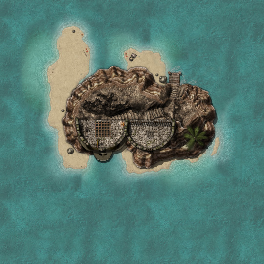
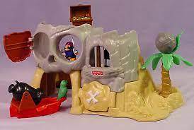
Fisher Price Pirate Island Battle Maps! 3500x3500
Many of my first adventures started on this ye lil island.
#fisher price#Dungeons and dragons#D&D#D&D 5e#5e#5th edition#D&D next#roll20#battlemap#battlemaps#pirate#sea map#island map#dungeon master#ttrpg#rpg#map#maps#DND#homebrew#pirate island#Dungeons & Dragons#Wizards of the Coasts
162 notes
·
View notes
Text


Les grandes îles de Pyrène, un massif noyé
2 notes
·
View notes
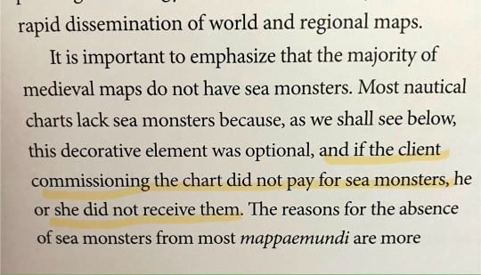
Text
Reading a book on sea monsters on ancient maps and I thought this was such a funny way to put it. They couldn’t even afford sea monsters :///
16K notes
·
View notes
Text

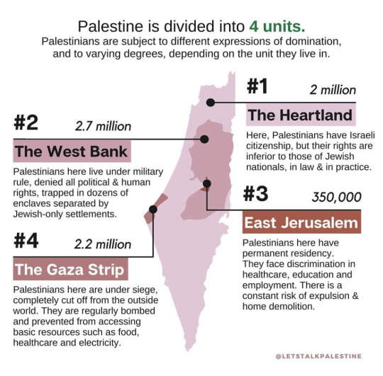
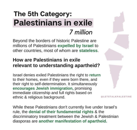
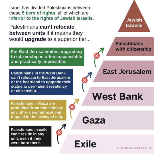
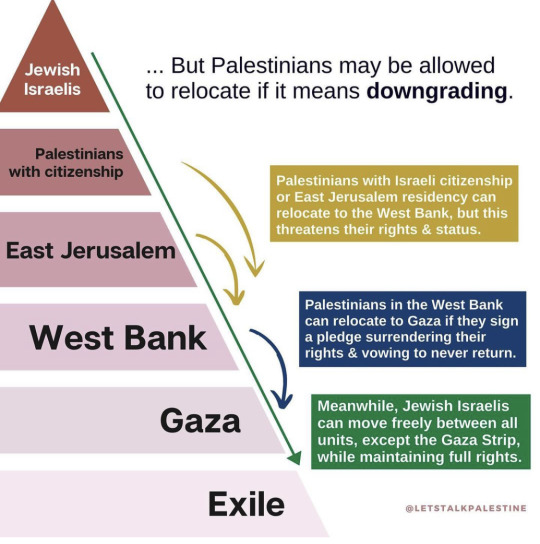
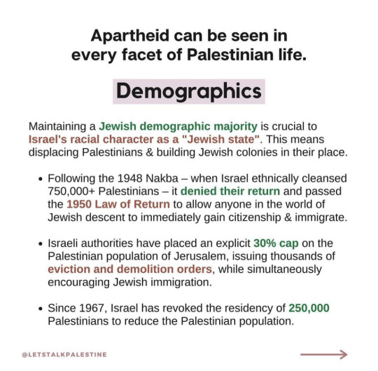

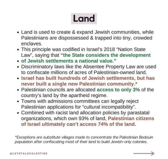
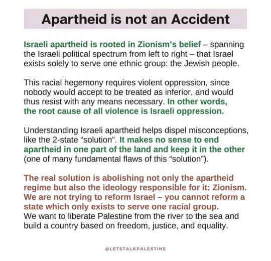
This is a simple introduction to how Israel rules Palestine 🇵🇸
#free palestine#palestine#gaza#israel terrorist#israel is a terrorist state#israel#stop israel#end the occupation#occupied palestine#occupation#politics#stop killing civilians#stand with gaza#map#justice for palestine#jewsforpalestine#jewish#freepalastine🇵🇸#from the river to the sea palestine will be free#palestine will be free#israelterrorists#support palestine#stop genocide
9K notes
·
View notes
Text
20 retro world map sticker
0 notes
Text
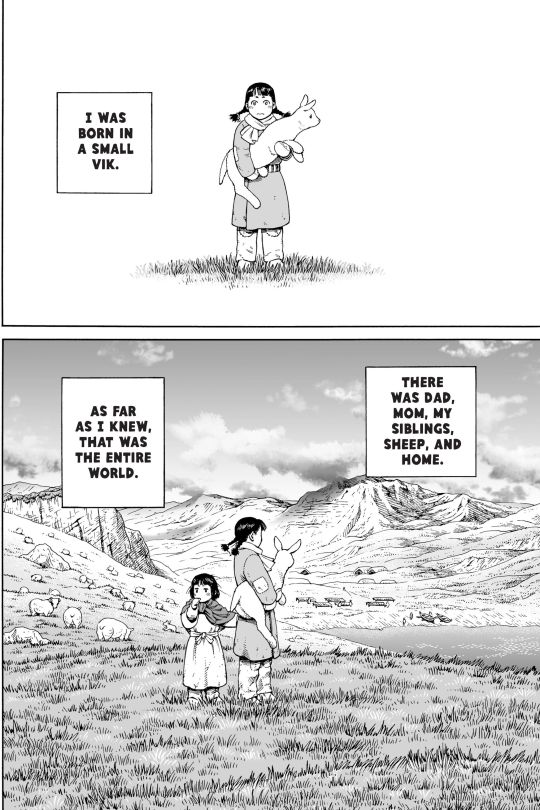
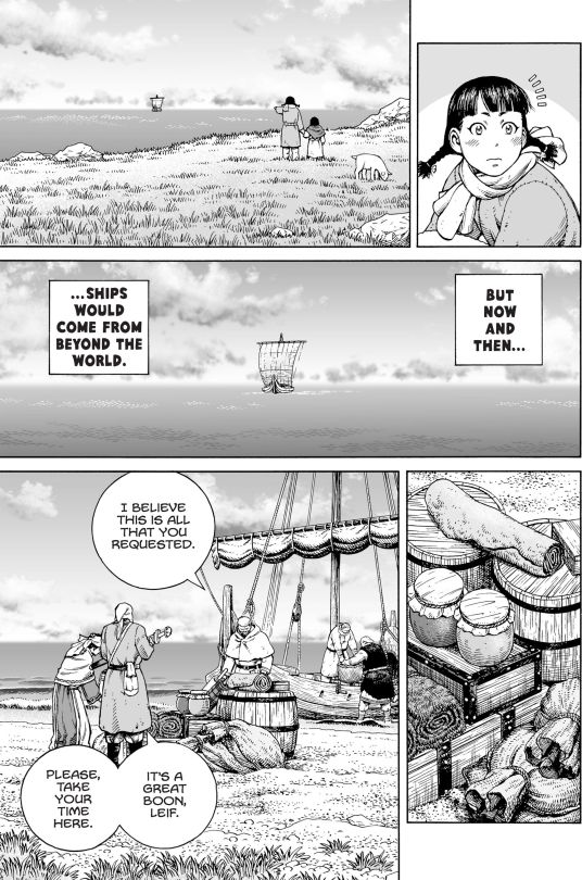

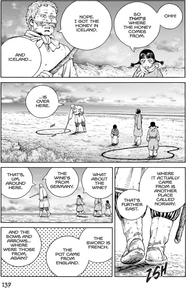

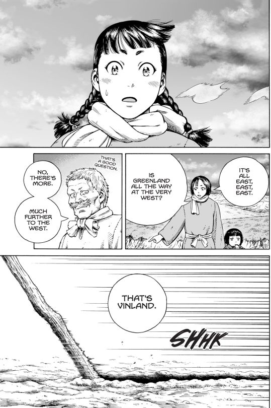
Source:
Vinland Saga
ヴィンランド・サガ
by Makoto Yukimura
#Vinland Saga#Makoto Yukimura#Manga and Stuff#Mangacap#Manga#Art#that's a pretty decent map of the north sea all things considered
4K notes
·
View notes
Photo

Netherlands if sea level were 1 meter higher.
2K notes
·
View notes
Text


GEM GEM GEM
#hermitcraft#hermitcraft season 10#geminitay#geminitay fanart#scooter.draws#my art#she’s based on those uhh#uhhh#old ocean map sea monsters#but it doesn’t REALLY translate into the design#I love her though 🫶#fanart#mcyt fanart
201 notes
·
View notes
Text


you can't be lgbtq and support the occupation that did this to them
#free palestine#palestine#from the river to the sea palestine will be free#pro palestine#boycott israel#news from the world#gaza#boycott starbucks#boycott disney#boycott mcdonalds#queering the map#palestinian queers#lgbtq#lgbtq community#save palestinians#god these stories are so sad#every person killed was someone's everything#jabalya#fuck israel#fuck the us#fuck zionism#kill israel#that bullet killed both of us#the palestinians are not numbers#fuck the occupation#bombs#bombing#gaza under bombardment#gaza under siege#gaza under genocide
239 notes
·
View notes
Text

#photography#aesthetic#beautiful#lifestyle#adventure#map#kraken#monster#sea#ocean#cartography#sailing#nautical#ship#navigation
224 notes
·
View notes
Text
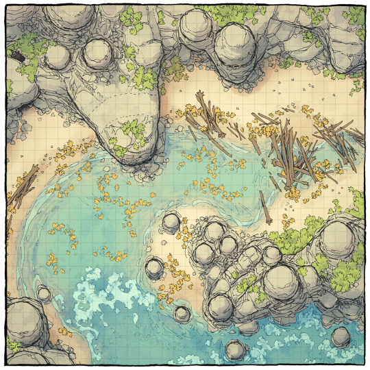
The Driftwood Cove Battle Map
You can now download our new 44x32 seaside battle map on our website! All you need is a team of monsters (or one big one). What comes to mind?
→ Download it here!
#ttrpg#tabletop#dungeons and dragons#dnd#dungeons & dragons#d&d#d&d5e#pathfinder#gurps#rpg#top-down#battle map#map#cartography#encounter#coastal#sea#ocean#beach#tropical#cliff#bay#cove
388 notes
·
View notes
Text
Watching the second movie rn lol
#the one sketch is her ‘superpower’ form like in the film#mostly based on those old sea monster drawings on maps#🎨 chy creations 🎨#❤️ coralbob ❤️
184 notes
·
View notes
Note
The Baltic Sea

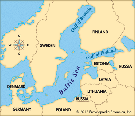
Baltic Sea, Earth
143 notes
·
View notes
Text
LJS 28 is a portolan atlas - that is, maps concerned with coastlines and ports. Made in Venice between 1535 and 1538, it includes maps of Britain, the Mediterranean, the Aegean sea, Adriatic Sea, and others, and a map of the world (part 2 of 2)
Online: https://bit.ly/3THQfpQ
#manuscript#earlymodern#map#portolan atlas#venice#britain#mediterranean sea#aegean sea#adriatic sea#book history#rare books
1K notes
·
View notes
Text
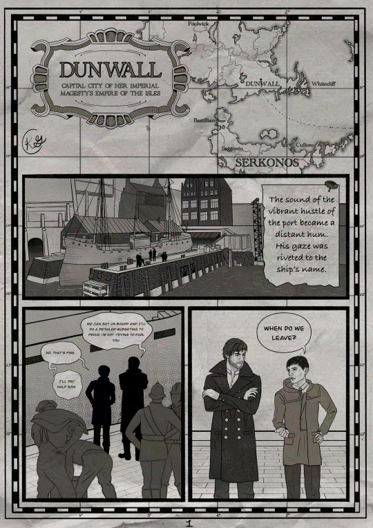


I've been bewitched body and soul by @uncontrol-freak's corvosider au in which Corvo is a grizzled sea captain, so I made a short fan comic for ch 2. If you want to know where the seas will take them, check out their fic, Abyssal!
Higher quality version linked here because tumblr always chews up my comics
#seriously though I highly recommend abyssal#corvosider out at sea what more could you want#seasoned and gruff captain attano has me swooning#overall though I’m pleased with how this comic turned out#big departure from my usual style and I think it paid off#the idea for it to be on old nautical maps is what struck me first while reading the fic#thanks for the inspiration!!#I love this fandom I love how we all feed off each others ideas and share with each other#(also yeah I’m finally glazing my art now and I hate how it makes it look. if you bring up the artifacts I WILL cry)#uncontrol-freak#my art#my comics#abyssal fic#dishonored#the outsider#corvo attano#corvosider#dishonored fanart#dishonored au
95 notes
·
View notes
Note
do you have any favorite illustrations of map sea creatures? like the guys they would draw on old maps cause (imo) plain old water was just too boring? I’d love to see them if you do!!
What a great question! Weirdly, the one map everyone thinks of when thinking of sea creatures on maps?
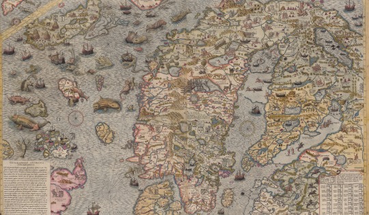
These were very much NOT space-filling. This map illustrated Olaus Magnus' history and geography of Scandinavia, and every single thing on it (including the sea monsters) is directly taken from his book. So it's kind of like making a map of Middle Earth and putting in the locations of all the trolls and dragons and stuff! Everything here is intentional!
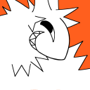
But in terms of monsters placed purely as decorative elements because the mapmakers felt like it, I think it's hard not to love this screaming head from Cosmographia Universalis et Exactissima by Giovanni Francesco Camocio (1569).

189 notes
·
View notes
Last Seen Blogs