#maps
Photo
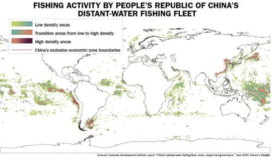
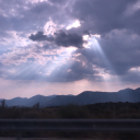
The extent of China's illegal fishing activities.
232 notes
·
View notes
Text
A bit of Exandria is coming to our world via Quest's End Sandkheg's Hide! Sign up to be notified when pre-orders launch! Comes with an amazing story by Jasmine Bhullar, art by @tylerwalpole and a map by me! https://sandkhegshide.com/
106 notes
·
View notes
Text
Hey All,
I've been away for some time, as we've been working really hard on something quite exciting:
let me present to you the world's first ever global ocean drainage basin map that shows all permanent and temporary water flows on the planet.

This is quite big news, as far as I know this has never been done before. There are hundreds of hours of work in it (with the data + manual work as well) and it's quite a relief that they are all finished now.
But what is an ocean drainage basin map, I hear most of you asking? A couple of years ago I tried to find a map that shows which ocean does each of the world's rivers end up in. I was a bit surprised to see there is no map like that, so I just decided I'll make it myself - as usual :) Well, after realizing all the technical difficulties, I wasn't so surprised any more that it didn't exist. So yeah, it was quite a challenge but I am very happy with the result.
In addition to the global map I've created a set of 43 maps for different countries, states and continents, four versions for each: maps with white and black background, and a version for both with coloured oceans (aka polygons). Here's the global map with polygons:
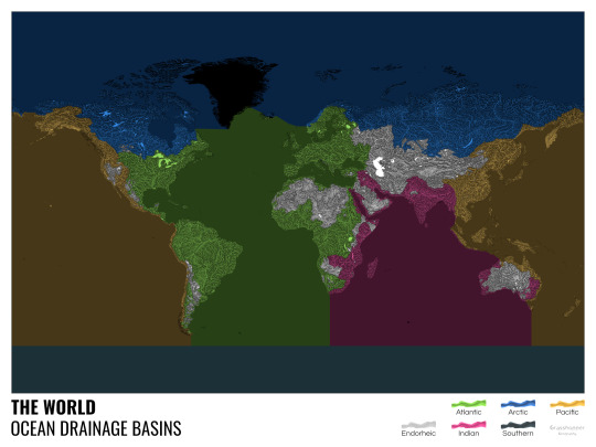
I know from experience that maps can be great conversation starters, and I aim to make maps that are visually striking and can effectively deliver a message. With these ocean drainage basin maps the most important part was to make them easily understandable, so after you have seen one, the others all become effortless to interpret as well. Let me know how I did, I really appreciate any and all kinds of feedback.
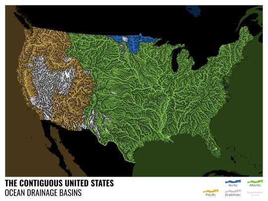
Here are a few more from the set, I hope you too learn something new from them. I certainly did, and I am a geographer.
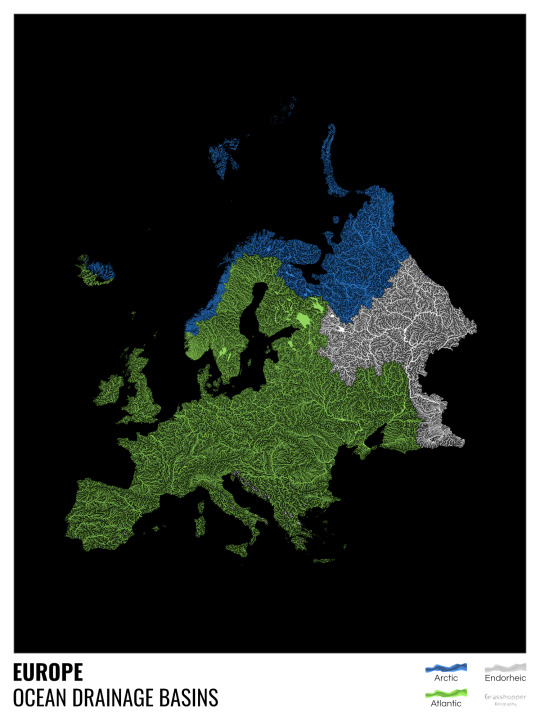
The greatest surprise with Europe is that its biggest river is all grey, as the Volga flows into the Caspian sea, therefore its basin counts as endorheic.
An endorheic basin is one which never reaches the ocean, mostly because it dries out in desert areas or ends up in lakes with no outflow. The biggest endorheic basin is the Caspian’s, but the area of the Great Basin in the US is also a good example of endorheic basins.
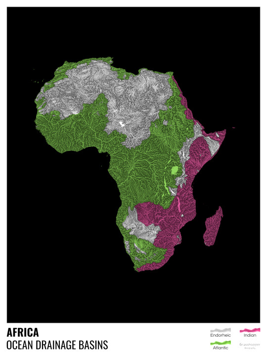
I love how the green of the Atlantic Ocean tangles together in the middle.
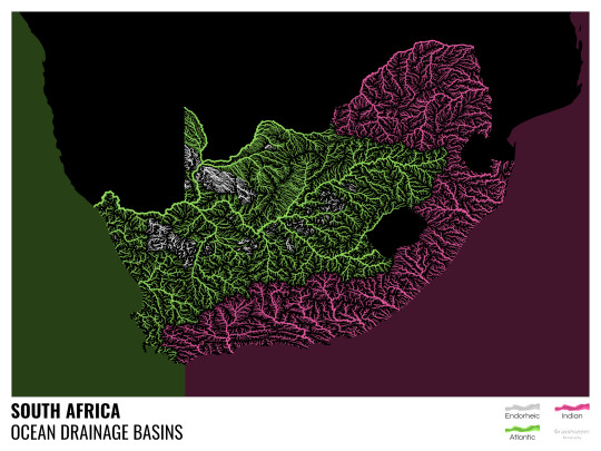
No, the dividing line is not at Cape Town, unfortunately.
I know these two colours weren’t the best choice for colourblind people and I sincerely apologize for that. I’ve been planning to make colourblind-friendly versions of my maps for ages now – still not sure when I get there, but I want you to know that it’s just moved up on my todo-list. A lot further up.
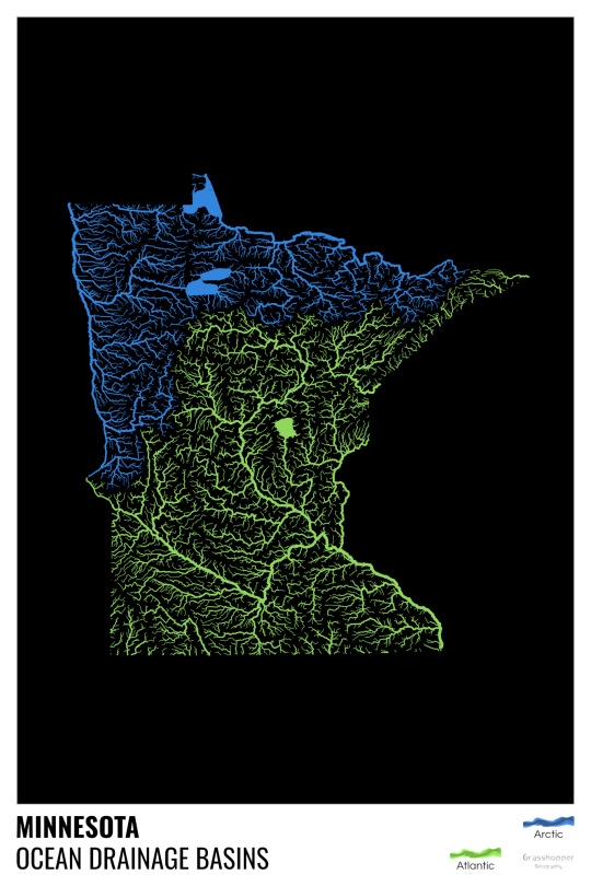
Minnesota is quite crazy with all that blue, right? Some other US states that are equally mind-blowing: North Dakota, New Mexico, Colorado, Wyoming. You can check them all out here.
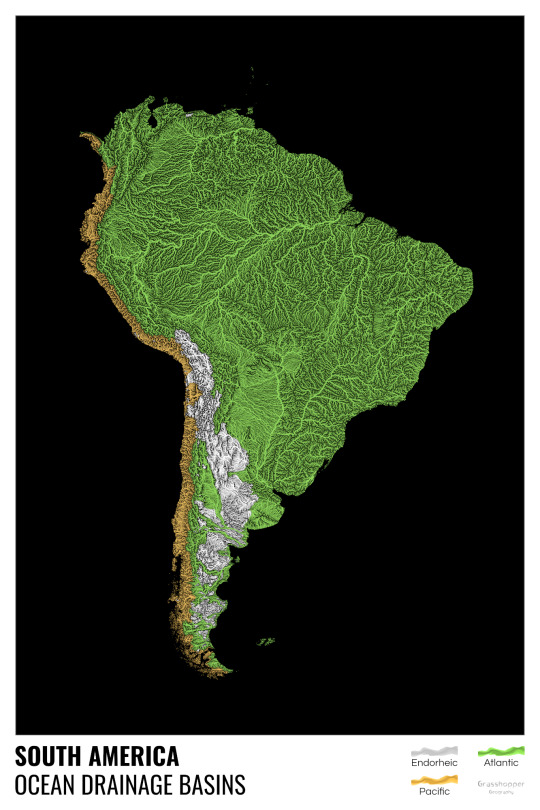
Yes, most of the Peruvian waters drain into the Atlantic Ocean. Here are the maps of Peru, if you want to take a closer look.
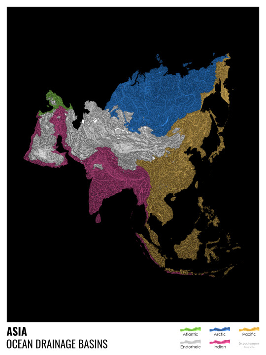
Asia is amazingly colourful with lots of endorheic basins in the middle areas: deserts, the Himalayas and the Caspian sea are to blame. Also note how the Indonesian islands of Java and Sumatra are divided.
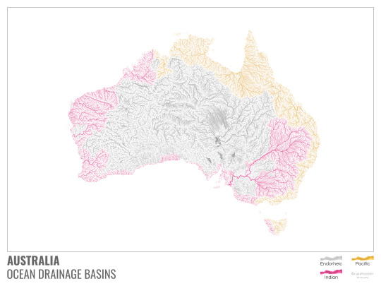
I mentioned earlier that I also made white versions of all maps. Here’s Australia with its vast deserts. If you're wondering about the weird lines in the middle: that’s the Simpson desert with its famous parallel sand dunes.
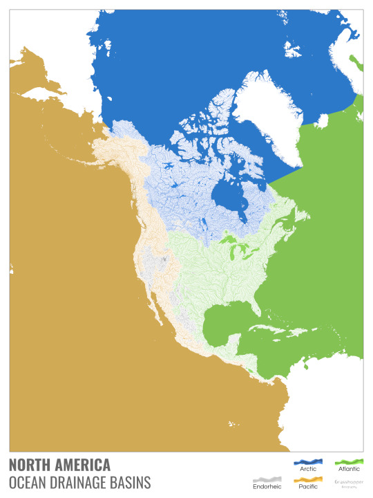
North America with white background and colourful oceans looks pretty neat, I think.

Finally, I made the drainage basin maps of the individual oceans: The Atlantic, the Arctic, the Indian and the Pacific. The Arctic is my favourite one.
I really hope you like my new maps, and that they will become as popular as my river basin maps. Those have already helped dozens of environmental NGOs to illustrate their important messages all around the world. It would be nice if these maps too could find their purpose.
#maps reimagined#geography#cartography#maps#my art#rivers of the world#ocean drainage basins#ocean maps#river maps
16K notes
·
View notes
Text
#nintendo#pokemon#funny#gaming#video games#lol#humor#meme#kyogre#hoenn#gba#gameboy advance#2000s#maps#geography#pokemon ruby#pokemon sapphire#pokemon emerald#pokemon oras#3ds#retro#2000ish#retrogaming#dank memes#gen iii#gen 3#legendary pokemon#team aqua#memes#pokemon omega ruby
17K notes
·
View notes
Text
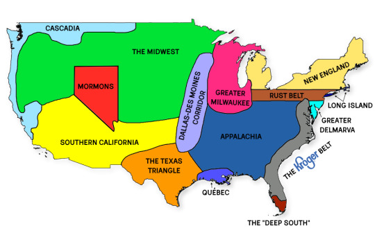
map of US social and cultural regions i made that you can use if you want to start a fight
27K notes
·
View notes
Text

Daily Mirror, England, December 9, 1907
4K notes
·
View notes
Text

Same-sex marriage in 2003 vs. 2013 vs. 2023
(20 years of change)
More info below:
----
2003:
Marriage : Netherlands, Belgium, British Columbia (CA), Ontario (CA)
Civil unions : France (including overseas territories), Germany, Denmark, Iceland, Sweden, Norway, Finland, Greenland, Rio Negro (AR), Ciudad de Buenos Aires (AR), California (US), New York (US), Hawaii (US), Vermont (US), Canary Islands (ES), Aragon (ES), Catalonia (ES), Andalusia (ES), Extremadura (ES), Castilla-La Mancha (ES), Castilla-Leon (ES), Madrid (ES), Valencia (ES), Asturias (ES), Basque Country (ES), Navarre (ES), Balearics (ES), Quebec (CA), Alberta (CA), Manitoba (CA), Nova Scotia (CA), Geneva (CH), Zurich (CH), Portugal.
----
2013:
Marriage : Netherlands, Belgium, Canada, Brazil, Uruguay, Argentina, South Africa, Spain, Portugal, France (including overseas territories), Denmark, Norway, Sweden, Iceland, New Zealand, Washington (US), California (US), New Mexico (US), Minnesota (US), Iowa (US), Maryland (US), DC (US), New Jersey (US), Delaware (US), New York (US), Connecticut (US), Rhode Island (US), Vermont (US), Massachusetts (US), New Hampshire (US), Maine (US), Hawaii (US), Mexico City (MX), Quintana Roo (MX).
Civil unions : Greenland, Colombia, Ecuador, Merida (VZ), United Kingdom, Ireland, Germany, Czech Republic, Austria, Finland, Hungary, Slovenia, Croatia, Switzerland, Luxembourg, Liechtenstein, Australia
Recognizes marriages performed abroad : All 32 Mexican states and Israel
----
2023:
Marriage : Netherlands (including overseas territories), Belgium, United States, Canada, Mexico, Costa Rica, Cuba, Puerto Rico, Colombia, US Virgin Islands, Ecuador, Brazil, Argentina, Uruguay, Chile, Malvinas/Falklands, France (including overseas territories), Spain, Portugal, Andorra, Germany, Slovenia, Switzerland, Austria, Malta, Guernsey, Jersey, United Kingdom, Isle of Man, Ireland, Gibraltar, Norway, Denmark, Sweden, Finland, Iceland, Greenland, Luxembourg, Faroe Islands, South Africa, Australia, New Zealand, Taiwan, Northern Mariana Islands, Guam, St. Helena, Pitcairn Islands, Gibraltar.
Civil unions : Bolivia, Italy, Cayman Islands, Bermuda, Aruba, Curaçao, Czech Republic, Hungary, Croatia, Montenegro, Greece, Cyprus, Estonia, Liechtenstein
Recognizes marriages performed abroad : Namibia, Israel, Nepal, American Samoa
----
Future :
Same-sex marriage is under consideration by the legislature or the courts in Aruba, Curaçao, the Czech Republic, Estonia, Greece, India, Japan, Liechtenstein, Namibia, the Navajo Nation, Nepal, Thailand, and Venezuela, and all countries bound by the Inter-American Court of Human Rights (IACHR), which includes Barbados, Bolivia, Dominican Republic, El Salvador, Guatemala, Haiti, Honduras, Nicaragua, Panama, Paraguay, Peru, and Suriname.
Civil unions are being considered in a number of countries, including Lithuania, Peru, the Philippines, South Korea, Ukraine, China, Hong Kong, Japan, Latvia, Panama, Romania, Serbia, Slovakia, Thailand, and Venezuela.
----
#map#maps#cartography#usa#latin america#mexico#data#americas#geography#europe#gay#lgbt#gay marriage#lgbtq#lgbtq history#lgbt history#history#lesbian#sapphic#marriage#pride
7K notes
·
View notes
Text
2K notes
·
View notes
Text


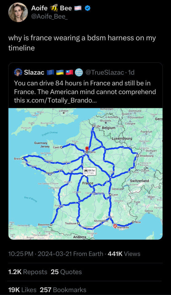
Lidar-Derived Aerial Maps Reveal the Dramatic Meandering Changes in River Banks Over Millennia
4K notes
·
View notes
Text
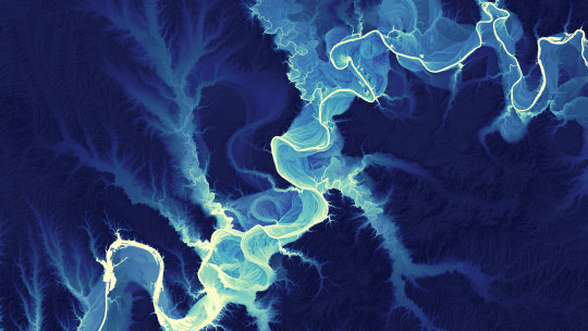
By the way, if any of you, like me, are nerds who love maps, I highly recommend checking out the Turgot map. I won't link it or tumblr will eat this post, but you can find it just by searching Wikipedia - it's an incredibly detailed 3D map of Paris made in the 1730s, and by "incredibly detailed," I mean
incredibly
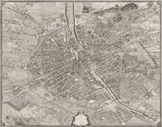
incredibly

INCREDIBLY
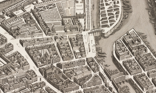
DETAILED!

Look, there's Notre Dame! Individual trees! Individual lampposts! Individual boats!! (Some of them even have little people in lol, though clearly not to scale)
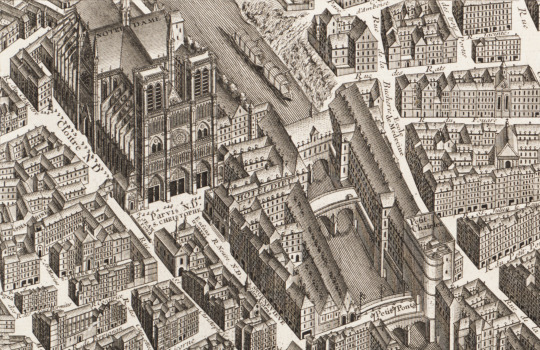
The full scan is over 35,000 pixels wide, guys! That's over 10 feet of map!! All drawn and engraved by hand! I'm freaking out a little! What an absolutely amazing piece of history & art!
#I'm slowly collecting stupidly detailed maps of Paris for book research but this is the wildest one I've found so far#and in 3D! It really gives you a sense of the city like nothing else#history#french history#Paris#maps
16K notes
·
View notes
Photo
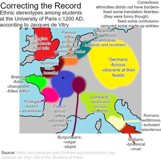
Corrected Version: Ethnic stereotypes among students at the University of Paris c.1200 AD, according to Jacques de Vitry
322 notes
·
View notes
Text
THIS
THIS IS WHAT MAKES TUMBLR BEAUTIFUL
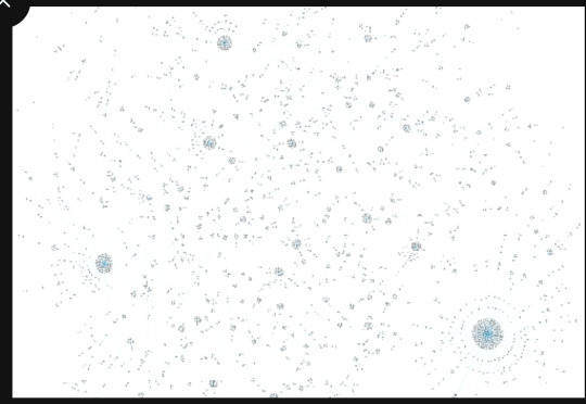
This is a 19K reblog post, thats less then 5K reblogs there
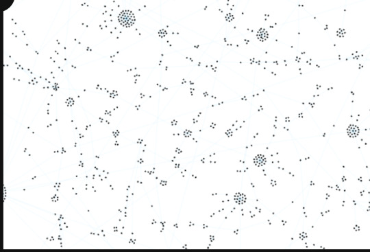
You can see where one person reblogged it and their mutuals then did too
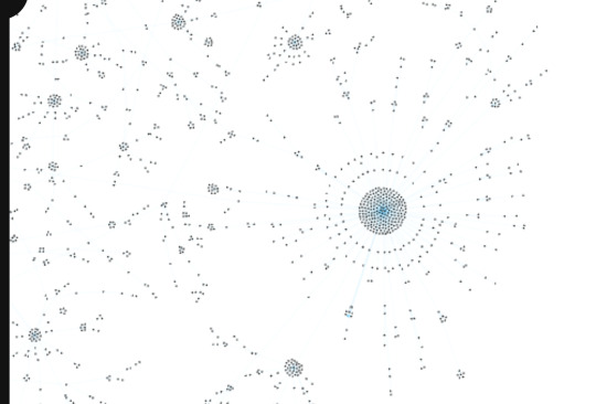
The original post looks like a city, you could make maps from this
Lets add more:
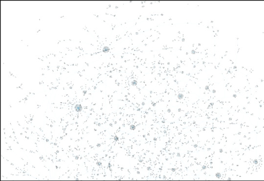
YOU CAN'T ZOOM OUT ANYMORE
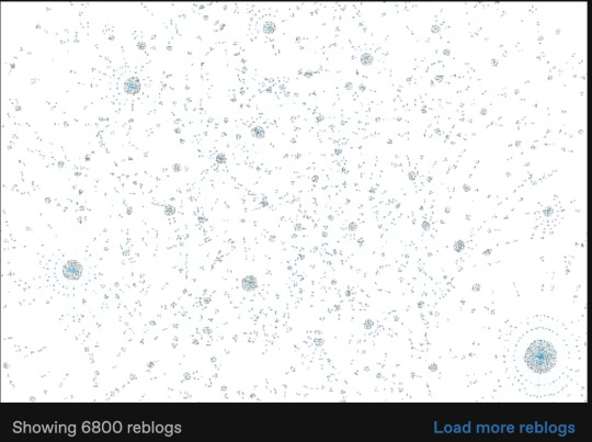
Only 6K here out of 19K, just the roads, the trails... you can see how people shared this post and the communities it found, wether small or large
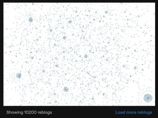
My laptop couldn't take anymore, but here, here is 10K out of 19K...
the original post is in the bottom right hand corner
this is what makes tumblr beautiful
#tumblr#hellsite#hellsite (affectionate)#hellsite my beloved#pretty#reblog#reblog map#what makes tumblr beautiful#beautiful#maps#map
4K notes
·
View notes
Text
call me a line on a map the way I be falsely presenting myself as straight
2K notes
·
View notes
Text
psa! for folks in north america, south america, or australia, you can use this interactive map to learn about the indigenous peoples and languages in your area — both historically and in the present day.
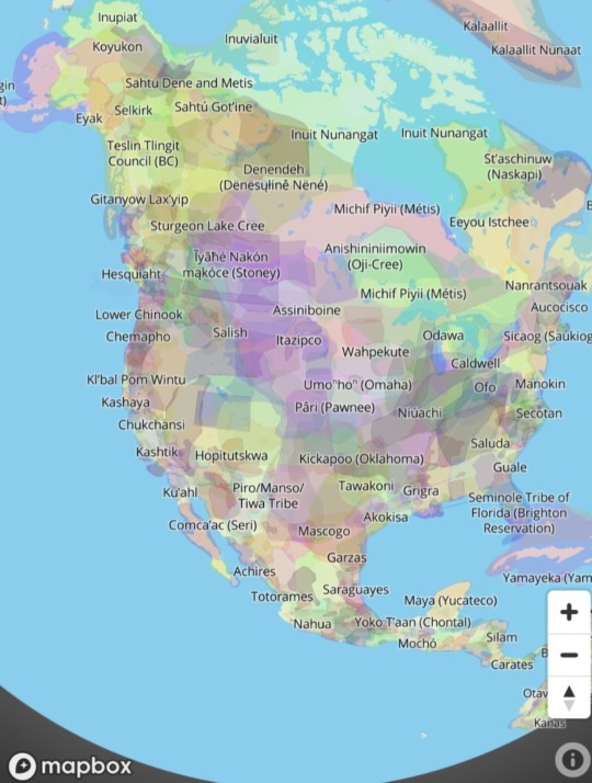
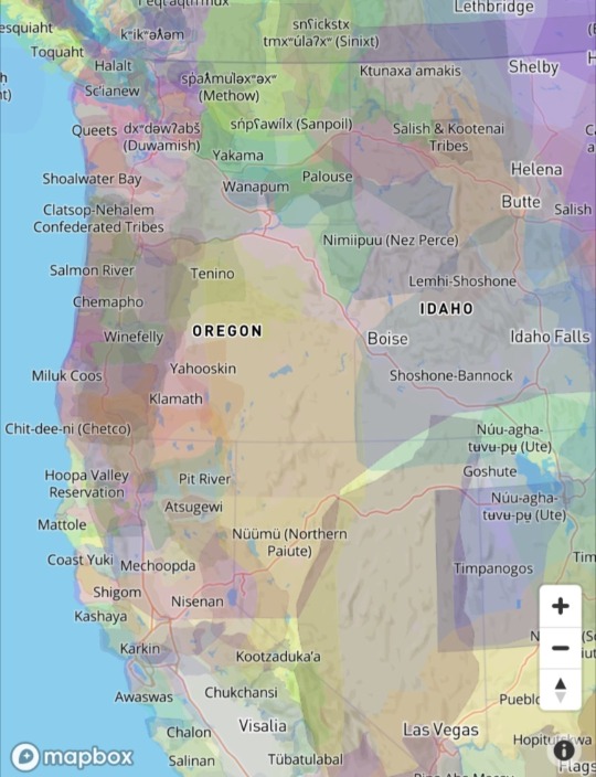
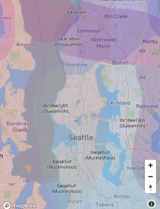
this is an excellent place to start if you're interested in learning about local history and your nearby indigenous communities. you can even put in your postal code to display data for your specific neighborhood or suburb. i recommend giving it a look!
1K notes
·
View notes
Text
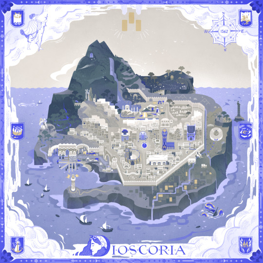
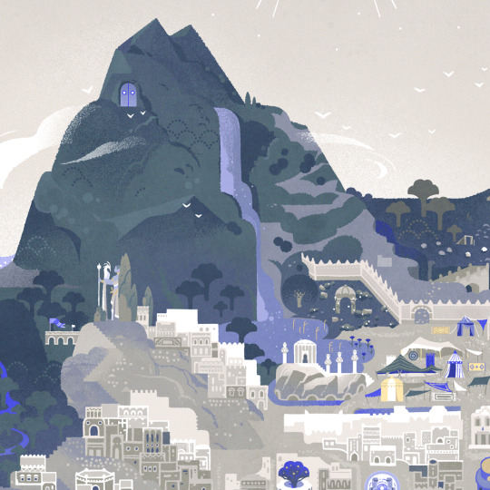
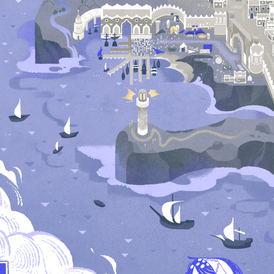
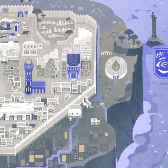
Discoria - The Hidden Isle 🌊
#illustrators on tumblr#artists on tumblr#illustration#ttrpg#the hidden isle#indie rpg#ttrpg community#island#map#nautical#maritime#seafaring#maps#sefirot tarot#Sefirot#had so much fun working on this map even though it took forever I'm so proud of it!#feel free to check out our newest Sefirot project
2K notes
·
View notes
Last Seen Blogs

thankyoucr1tikal
big moist

breastmassage
Boob treatment

destiny-doodles
Destiny Doodels

autumn-kinsman
secret life enthusiast