#tropical cyclone
Text
As someone (from the USA) who survived a severe hurricane, if there is one piece of advice I could give, PLEASE listen to any evacuation orders. This goes for voluntary and mandatory, but ESPECIALLY mandatory. If you can't get outside the evacuation zone, even just getting closer to the boundary is better than nothing.
If you are in a mandatory evacuation zone and you stay, no one (no emergency services) will be coming to save you. You will have to hunker down for however long the storm lasts.
The time to prepare for evacuation is as soon as you know you're under evacuation order, at LEAST. Do NOT delay. You don't want to be like my family who only left once the flood began (thanks, dad). Not only did we have to hurry to pack, we weren't able to prepare. At that, here are some good things to do in a hurricane:
Have a radio - an emergency crank radio is good, since it uses mechanical energy. We also had walkie talkies.
Have a good first aid kit, especially if you cant get out.
Unplug anything that you absolutely do not need while home, unplug everything before you leave. We didn't do this and my house almost caught fire (fridge outlet) - only the flood put it out.
Have a working fire alarm, charge flashlights and devices. Make sure you also have candles and lighters, too.
Be VERY careful if you must wade or drive in flood water. There will be debris, there will be down power lines. It is deeper than it looks.
Stock up on water and nonperishable food. Eat your perishable foods now. Use coolers for any excess. MREs are good to have, you can order them online.
Put belongings you can't take with you as high up in your house as you can - prioritize things that cannot be easily/emotionally replaced. Leave space for you to go high up too, if you're staying.
Use sand bags (or DIY alternatives) as flood barriers. Tie or tarp down everything you can, and don't keep it in a wide open area.
Close windows, and stay away from them. You really don't want to be there when something comes flying.
This is all I can think of for now, others feel free to add more or correct me. Remember, your life is more important than objects. Losing your life is worse than losing everything but your life. Stay safe, and stay alive.
#ifairy#hurricane#tropical storm#natural disasters#natural disaster#hurricane preparedness#hurricane prep#hurricane season#safety#safety tips#health and safety#health#storm#storms#tropical cyclone
143 notes
·
View notes
Text
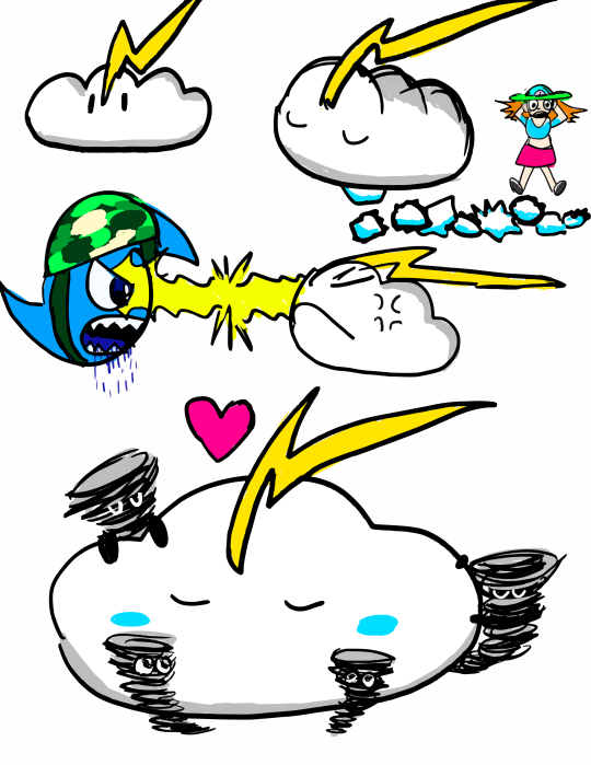

MELISSA AND THE ALLIES OF GAIA ART DUMP 1 - THE SUPERCELL
In episode 9 of the story "Melissa and the Allies of Gaia" I posted on Wattpad in August, Melissa and her storm avatar partner Hurricane Carla (shown in her miniature form) face off against a sapient high-precipitation supercell over a salt marsh in Alabama. A pair of fisherman have been using the tornadoes/waterspouts it creates to catch fish, having used an artifact of evil weather magic to take control of the storm.
Since actually moving to Alabama (I had no idea I would end up there at the time I wrote the story chapter) I have kind of developed a new fondness for this character. Most of the characters in the story I have done art previously for but I have never drawn this one.
While I don't specify this in the story, I imagine this supercell to use she/they pronouns (insert mammatus cloud joke here) and the tornados are like her "children" that she lets out to "play" (I mean if you scaled up a toddler to the size and strength of a tornado you'd probably get as much destruction). I plan for her to come back in a sequel, though of course Melissa will end up calling her something like "Mr. Thunders." (not that I imagine she would care all that much, of course, being a giant storm and all).
Like the hurricane avatars, she has a miniature form (shown in the top image) that she stays in when conditions aren't right for her to build up her massive supercell body. It looks like a cute little cumulus cloud with a thunderbolt crest. She doesn't speak any human language, and in the story she only briefly speaks in the wind language of storms to Carla, so she isn't very talkative. For this reason I imagine Melissa might one day try to keep her as a pet, which of course goes terribly wrong (as you can see in the first page with "Mr. Thunders" pooping huge spiky hail all over her apartment ["Mr Thunders! Not on the car!"]).
Shown in the top image is also her standing off against the miniature form of Labor Day and glaring at him with lightning. This happens in the story because Labor Day gets really hungry after the wind shear causes dry air to be entrained in his circulation and he basically loses control for a brief moment and tries to eat her waterspouts. Needless to say "Mr. Thunders" doesn't like this one bet, and attacks Labor Day. Fortunately it turns out "Mr. Thunders" also is hungry for some warm moist air too and they end up just kind of returning to Gulf Coast Headquarters and having lunch on some tropical air from the Gulf of Mexico.
The final drawing on the first image shows them snuggling with their tornado children. Ultimately I imagine she only wants what is best for them. It just so happens that sometimes what is best for a tornado isn't what is best for humans.
Some more notes on her design:
-Since she's a high precipitation supercell I imagine she has a lot of precipitation falling both from her anvil and from her base, which obscures anything like the wall cloud etc. This also conveniently means I don't have to draw all the features in the base of the supercell because I can't make heads or tails of how they are arranged lol (you can tell I have more experience with tropical cyclones)
-I basically imagined her thunderhead anvil is like her hat. It actually extends far ahead of and behind her head (it is extended by the upper level wind shear) but since she's viewed from the front it is foreshortened. From the side it would be quite long.
-Her eye color is supposed to be the deep green seen in storms with a lot of hail as the sun sets. I imagine her triangular pupil actually looks like a conical tornado up close.
-I had previously in the webcomic drawn Melissa as having a peace sign beanie or skullcap, but I realized when writing the story that that sort of hat doesn't make sense for her home of Galveston, which has a hot climate. I imagine it's more of a sunhat now. (Okay this isn't about the supercell's design but I think it's important)
#character designs#meteorology#supercell#storm#cloud#thunderstorm#tornado#waterspout#hurricane#tropical cyclone#weather#sky
4 notes
·
View notes
Text
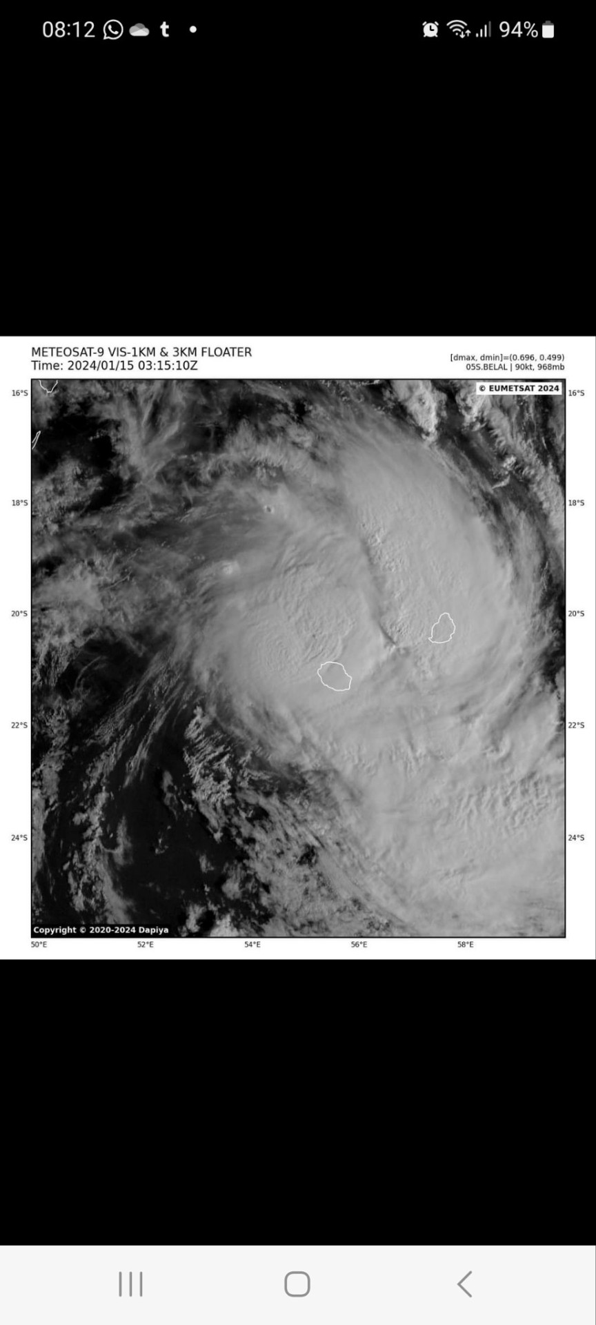
Today there is a tropical cyclone where I live. It's very common during this period but, this time it's passing directly upon us and I must say it's pretty scary 😨
2 notes
·
View notes
Text
Typhoon Mawar satellite animation
From tropical storm to category-5 equivalent intensity: 6 days of Typhoon Mawar via Himawari-9 infrared (IR) imagery.
According to the Joint Typhoon Warning Center (JTWC), Mawar's estimated peak wind speed of 160 kt (185 mph) has been achieved by only 13 other typhoons since 1979.
As noted by Dr. Jeff Masters on Twitter, 185 mph ties Mawar with Phyllis (1958) as the strongest observed May typhoon, and only Surigae (2021) achieved a higher intensity earlier in the year (it occurred in April).
vimeo
#typhoon mawar#tropical cyclone#infrared satellite imagery#satellite animation#storm-following satellite animation#Vimeo
2 notes
·
View notes
Text
New Zealand declares emergency over Cyclone Gabrielle
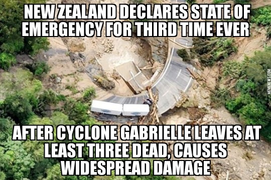
View On WordPress
#cyclone Gabrielle#emergency#hurricane#meme#memes#natural disaster#New Zealand#news#tropical cyclone#tropical storm#weather
3 notes
·
View notes
Text
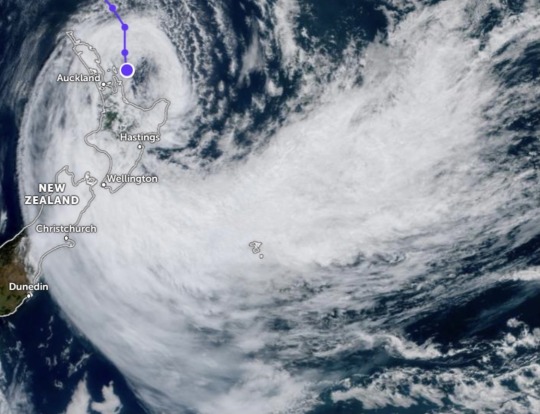
hi guys, non dw post here just an update!
this is the current location of Cyclone Gabrielle over NZ (it’s currently 12:45pm). We are okay but us along with all of the North Island were absolutely battered last night by the horrific full force of Gabrielle. It was the worst storm I have seen in my entire life and lasted all through the evening and night. It was extremely loud and violent. There was debris from neighboring properties hitting our windows and I am shocked that none shattered. Many are evacuated, flooded, injured, and trapped in cars and destroyed homes from landslides. There is now a national state of emergency.
I didn’t sleep at all through the night. Power and cell service went out at 4am and power is finally back on for us now but cell service is still out. We are luckier than a lot of people in that we have power back and no destruction to our house bar some plants ripped out and the fence between us and next door coming apart.
posting will be slow as we deal with the current situation and make sure family and friends are safe. thanks and let there be fez.
#cyclone gabrielle#tropical cyclone#gabrielle#nz cyclone#New Zealand#New Zealand cyclone#ETC Gabrielle#TC Gabrielle#state of emergency#text post#moody who#doctor who
2 notes
·
View notes
Link
#Data#Google Trends in the Territories#American Samoa#Contextomy#Eclipse#Guam#Israel#NBA#Northern Mariana Islands#Puerto Rico#Storm#Tropical Cyclone#Typhoon#US Virgin Islands
0 notes
Text
Hurricanes More Likely to Kill Minorities in the U.S.
Atlantic tropical storms are more likely to kill minorities and those in other vulnerable communities, according to a new study published in Science Advances.
Hurricanes and Climate | Extreme Earth
A team of storm researchers and public health experts recently looked at Atlantic storms to calculate how many excess deaths occurred after a tropical storm. They looked at the thousands of deaths…
View On WordPress
#Accident#Atlantic hurricane seasons#Disaster#Environment#Gizmodo#Hurricane Maria#Ian#Robbie Parks#Social Issues#Tropical cyclone#Tropical cyclones and climate change
0 notes
Photo

UN and partners calls for $70.6 million to provide life-saving assistance to people in Malawi
Country: Malawi Sources: UN Office for the Coordination of Humanitarian Affairs, UN Resident Coordinator in Malawi The revised Flash Appeal aims to assist 1.1 million people affected by the passage of the Tropical Cyclone Freddy across the Southern Region in March 2023, in support of the Government-led response.
https://reliefweb.int/report/malawi/united-nations-and-humanitarian-partners-call-us706-million-provide-life-saving-assistance-people-malawi-affected-passage-cyclone-freddy
#Malawi#UN Office for the Coordination of Humanitarian Affairs#UN Resident Coordinator in Malawi#Food and Nutrition#Health#Protection and Human Rights#Shelter and Non-Food Items#Water Sanitation Hygiene#News and Press Release#Epidemic#Tropical Cyclone#ReliefWeb - Updates (Headlines)
0 notes
Text
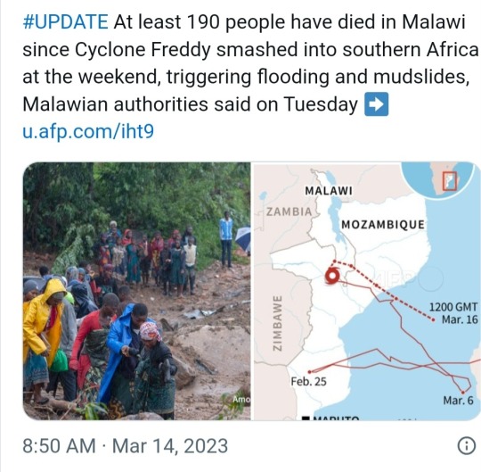
Tropical Cyclone Freddy sets world record for longevity

Tropical Cyclone Freddy sets new record
On February 5, 2023, Tropical Cyclone Freddy formed in the eastern Indian Ocean near northern Australia. From the beginning, the cyclone appeared formidable on satellite images as it headed west. It then traversed the entire Indian Ocean over the course of a month. And now – on March 14 – Freddy is still active. It has raged for 37 days, setting a new record as the world’s longest-lived tropical cyclone.
It easily beat out Hurricane John (1994), which lasted for 31 days in the Pacific Ocean. And John had surpassed both 1992’s Hurricane Tina in the Pacific (24 days), as well as the 1899 San Ciriaco hurricane’s previous world record of 28 days in the 1899 Atlantic season.
Freddy was only the 4th known cyclone to travel the Indian Ocean from east to west. The powerful and now-deadly storm made landfall on Madagascar on February 21, then crossed over the Mozambique Channel before making landfall in Mozambique. It returned to the channel on March 1, brushing Madagascar again and then returning to Mozambique for a second landfall.
Freddy was equivalent to a Category 5 hurricane
As Freddy churned over this region of Africa, it produced copious rainfall, deadly flooding and mudslides. As of March 14, 2023, more than 200 people have died from Freddy.
Freddy also set a record for the highest accumulated cyclone energy (ACE) of any tropical cyclone in the Southern Hemisphere. At its strongest, Freddy was equivalent to a Category 5 Atlantic hurricane with winds more than 160 miles per hour.

This is the track of Cyclone Freddy. It began near Australia and crossed the entire Indian Ocean to hit Madagascar and Mozambique repeatedly. The dots show the storm’s location at 6-hour intervals, and the colors correspond to its strength in those locations, with purple being the strongest. Image via Wikimedia Commons.
Freddy’s disastrous effects in Africa
Freddy caused death and destruction everywhere it hit. The current death count stands at 17 people in Madagascar, 20 in Mozambique, 2 in Zimbabwe, and 190 in Malawi. The flooding in Malawi was particularly severe in Blantyre, the country’s second-largest city.
Earthsky.org
0 notes
Link
Ian started trekking through the Carolinas Friday, hammering the coast of South Carolina with flooding as it made landfall as a Category 1 hurricane, then taking aim at North Carolina as a post-tropical cyclone.
0 notes
Text


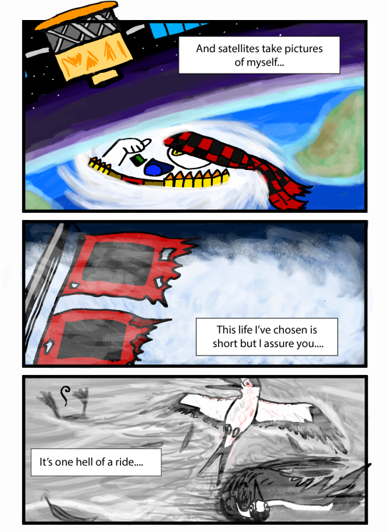
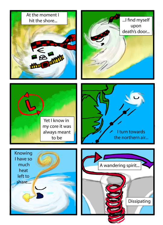

JUST A HEAT ENGINE - ALL COLLATED
I posted these comic pages as a series in 2021 but I never have posted them all together as a single comic. So here it is! "Just a Heat Engine" in full glory!
This is basically the avatar of the Labor Day Hurricane of 1935 (who has both a small blue mini dog-sized form and a white full-sized hurricane form) singing about the life of a hurricane...to the tune of the song "Comet" from Steven Universe.
#webcomic#hurricane#meteorology#song parody#steven universe#tropical cyclone#ocean#sky#atmospheric physics#music#song
2 notes
·
View notes
Link
Ian started trekking through the Carolinas Friday, hammering the coast of South Carolina with flooding as it made landfall as a Category 1 hurricane, then taking aim at North Carolina as a post-tropical cyclone.
0 notes
Video
youtube
Hurricane Fiona makes landfall in Canada as post-tropical cyclone
0 notes
Text
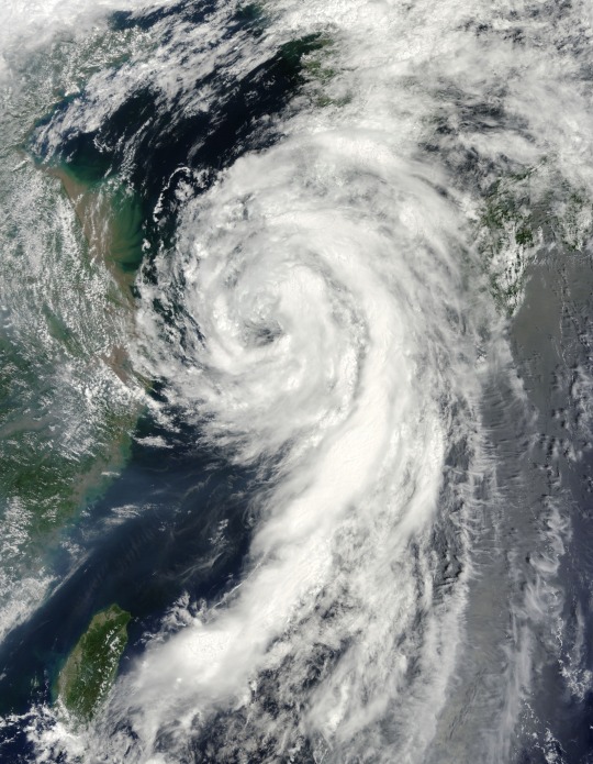


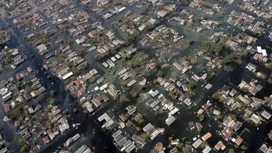
via NASA Goddard Space Flight Center
#storms#hurricane#typhoon#tropical storm#cyclone#aerial#nature#weather#nasa#satellite images#ocean#land#landscape#terrain#photography#green#water#blue#white
308 notes
·
View notes
Text
youtube
Warming seas supercharge existing tropical storms and have caused the Atlantic Basin hurricane season to start earlier and end later.
Rapid intensification has been happening more often than in the previous century.
No two storms are exactly alike – that's one factor which makes hurricane observation so interesting. While Hurricane Idalia was powerful, it was also compact. Its relatively modest footprint was good news for Floridians away from its direct path in terms of wind damage.
#tropical cyclones#hurricane idalia#florida#atlantic basin hurricane season#climate change#rapid intensification#warming seas#corene matyas#chad myers#jake tapper
26 notes
·
View notes
Last Seen Blogs

bhanusindian
Yumy Food!

spermwhales-and-petunias
The Bitchy Crosstown Express

rpgressource
RPG ressource

marcusmerrild
marcusmerrild

captaineliotfan
Granny panty :)