#the first UNESCO World Heritage Site in the world
Text
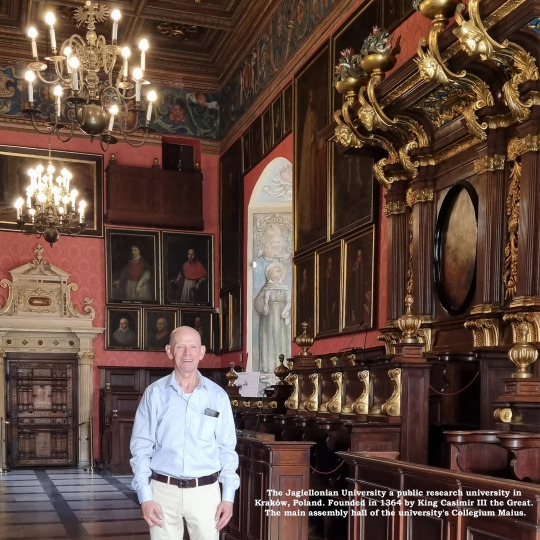
The Jagiellonian University a public research university in Kraków, Poland.
The Jagiellonian University a public research university in Kraków, Poland.
The main assembly hall of the university’s Collegium Maius.
The Jagiellonian University (Polish: Uniwersytet Jagielloński (UJ) a public research university in Kraków, Poland. Founded in 1364 by King Casimir III the Great.
The Jagiellonian University comprises 16 Faculties, where nearly 4 thousand academic staff conduct research and provide education to almost 40 thousand students, within the…
View On WordPress
#Andrzej Duda#Jagiellonian University#John III Sobieski#King Casimir III the Great#King of Poland#Kraków#Krakow#Nicolaus Copernicus#Nobel Prize in Literature#Notable alumni#Poland#Polish Enlightenment#Pope John Paul II#President of the Republic of Poland#Renaissance#Stanisław Lem#the first UNESCO World Heritage Site in the world#The Jagiellonian University#the theory of Heliocentrism#UJ#Uniwersytet Jagielloński#Wawel Royal Castle#Wisława Szymborska
6 notes
·
View notes
Text
i fell down a wikipedia rabbit hole and now it's one a.m. and i have to wake up at 8 this morning. so. there goes my hopes of productivity tomorrow i guess (i have so many things i need to do) (and i don't have the executive function skills to do them all) (ideally i should've finished 2-3x as much stuff as i actually have by now) (oops that turned into a bit of a vent) (i'm fine, none of this is world-shattering, life goes on even if i miss a few assignments. i will be kind to myself no matter what)
#i was reading about Slovenia btw#did you know that Slovenia has the lowest income inequality in the world as defined by the Gini coefficient?#and is one of the most socially progressive countries in eastern europe? it's the first post-communist country to legalize gay marriage#it's also incredibly biodiverse and is one of the most forested countries in europe#they have a bunch of endemic cave species!!#the Škocjan caves in Slovenia are a UNESCO world heritage site
0 notes
Text
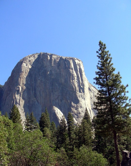
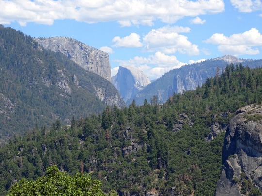


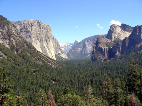

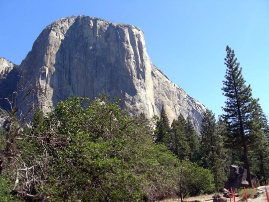

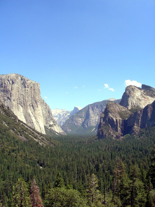
A team of rock climbers led by Warren Harding completed the first ascent of The Nose on El Capitan in Yosemite Valley on November 12, 1958.
#Warren Harding#first ascent#El Capitan#12 November 1958#65th anniversary#Yosemite National Park#UNESCO world heritage site#California#US history#nature#Sierra Nevada#mountain#woods#forest#tourist attraction#travel#vacation#summer 2008#landscape#countryside#pine#Yosemite Valley#Western USA#West Coast#mountaineering#Tunnel View#Half Dome#2022#Olmsted Point
0 notes
Text
"The Yurok will be the first Tribal nation to co-manage land with the National Park Service under a historic memorandum of understanding signed on Tuesday [March 19, 2024] by the tribe, Redwood national and state parks, and the non-profit Save the Redwoods League, according to news reports.
The Yurok tribe has seen a wave of successes in recent years, successfully campaigning for the removal of a series of dams on the Klamath River, where salmon once ran up to their territory, and with the signing of a new memorandum of understanding, the Yurok are set to reclaim more of what was theirs.
Save the Redwoods League bought a property containing these remarkable trees in 2013, and began working with the tribe to restore it, planting 50,000 native plants in the process. The location was within lands the Yurok once owned but were taken during the Gold Rush period.
Centuries passed, and by the time it was purchased it had been used as a lumber operation for 50 years, and the nearby Prairie Creek where the Yurok once harvested salmon had been buried.
Currently located on the fringe of Redwoods National and State Parks which receive over 1 million visitors every year and is a UNESCO Natural Heritage Site, the property has been renamed ‘O Rew, a Yurok word for the area.
“Today we acknowledge and celebrate the opportunity to return Indigenous guardianship to ‘O Rew and reimagine how millions of visitors from around the world experience the redwoods,” said Sam Hodder, president and CEO of Save the Redwoods League.
Having restored Prarie Creek and filled it with chinook and coho salmon, red-legged frogs, northwestern salamanders, waterfowl, and other species, the tribe has said they will build a traditional village site to showcase their culture, including redwood-plank huts, a sweat house, and a museum to contain many of the tribal artifacts they’ve recovered from museum collections.
Believing the giant trees sacred, they only use fallen trees to build their lodges.
“As the original stewards of this land, we look forward to working together with the Redwood national and state parks to manage it,” said Rosie Clayburn, the tribe’s cultural resources director.
It will add an additional mile of trails to the park system, and connect them with popular redwood groves as well as new interactive exhibits.
“This is a first-of-its-kind arrangement, where Tribal land is co-stewarded with a national park as its gateway to millions of visitors. This action will deepen the relationship between Tribes and the National Park Service,” said Redwoods National Park Superintendent Steve Mietz, adding that it would “heal the land while healing the relationships among all the people who inhabit this magnificent forest.”"
-via Good News Network, March 25, 2024
#indigenous#land back#indigenous issues#first nations#native american#indigenous peoples#yurok#yurok tribe#national parks service#national park#redwoods#california#trees#trees and forests#united states#good news#hope#indigenous land
5K notes
·
View notes
Text
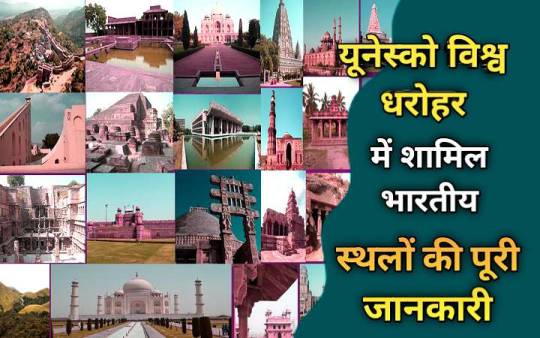
यूनेस्को की विश्व धरोहर में शामिल भारतीय धरोहर की सूची
यूनेस्को की विश्व धरोहर में शामिल भारतीय धरोहर
पूरी दुनिया में एक से बढ़कर एक हैरतअंगेज स्थल है जिनमे से कुछ को यूनेस्को द्वारा अपने विश्व विरासत स्थल में शामिल किया हैं। भारत मे भी यूनेस्को ने ऐसे बहुत से जगहों को अंकित किया है। तो आज हम इस आर्टिकल में जानेंगे यूनेस्को की चिन्हित उन्ही विश्व धरोहर स्थलों के बारे में। तो चलिए देखते है यूनेस्को की विश्व विरासत में शामिल भारतीय धरोहर की सूची और…
View On WordPress
#How many UNESCO heritage sites are there in India#How many UNESCO sites are there in India#How many world heritage sites are there at present#UNESCO World Heritage List#unesco world heritage sites in india#Which is the first UNESCO World Heritage City of India#Which is the UNESCO World Heritage Site#Which state has the maximum number of UNESCO World Heritage Sites in India#भारत की बात#यूनेस्को की विश्व धरोहर#यूनेस्को में शामिल बायोस्फीयर रिजर्व#यूनेस्को विश्व धरोहर स्थल में शामिल भारतीय विरासत स्थल
0 notes
Text
Beni Hammad Fort is in a fortified palatine city in M'Sila Province, Algeria 🇩🇿.
The fortress was built in 1007 AD by Hammad ibn Buluggin and became later the first capital of the Hammadid dynasty in 1017 AD.
In 1980, it was inscribed as a World Heritage Site by UNESCO under the name Al Qal'a of Beni Hammad, and described as "an authentic picture of a fortified Muslim city".

#beni#fort#city#province#algeria#fortress#first#capital#dynasty#world#heritage site#unesco#authentic#picture#world heritage#muslim#photography#ruins#travel#travel photography#photographer#photo of the day#travelgram#raash#instagram#facebook#twitter#tumblr#heritage#hammad
0 notes
Text
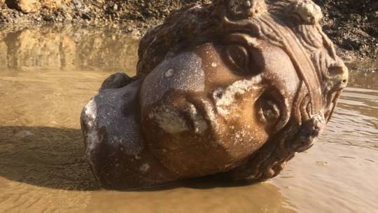
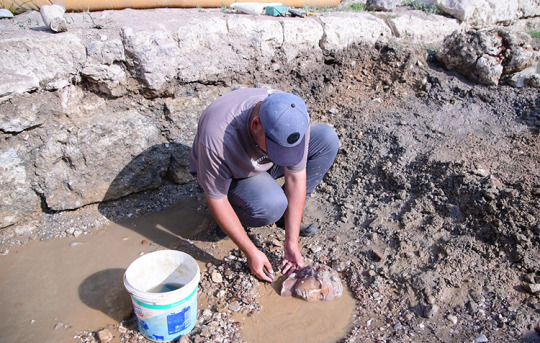
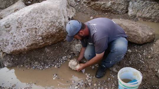
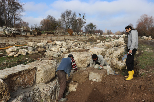
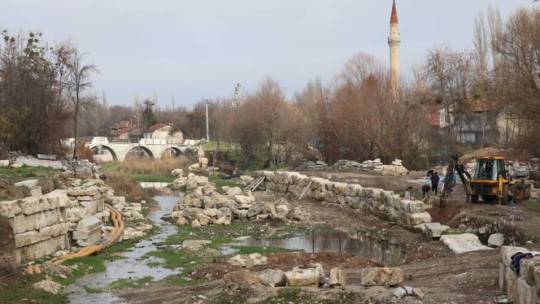
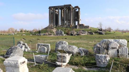
Turkish Archaeologists Unearth Sculpted Heads of Ancient Greek Deities
The excavations in Kutahya province’s ancient city of Aizanoi, which is the site of many ancient Greek and Roman-era settlements, discover the statue heads of Dionysus and Aphrodite.
Turkish archaeologists have discovered more sculpted heads of ancient Greek deities during excavations in Türkiye's western Kutahya province.
The statue head of Aphrodite, known as the goddess of love and beauty in Greek mythology, and the statue head of Dionysus, the deity of wine, were discovered during excavation work in an ancient city in central Türkiye.
Modern Türkiye is the site of many ancient Greek and Roman-era settlements.
With a history dating back 5,000 years, Aizanoi, situated 50 kilometres (31 miles) from the Kutahya city centre, was included in the UNESCO World Heritage Tentative List in 2012.
Archaeological excavations are currently underway in Aizanoi, which is located in the Cavdarhisar district of Kutahya province and is home to Anatolia's best-preserved Temple of Zeus.
Archaeology professor and excavation team leader Gokhan Coskun told Anadolu Agency that numerous statue pieces were discovered during the excavation.
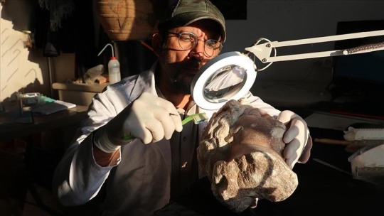
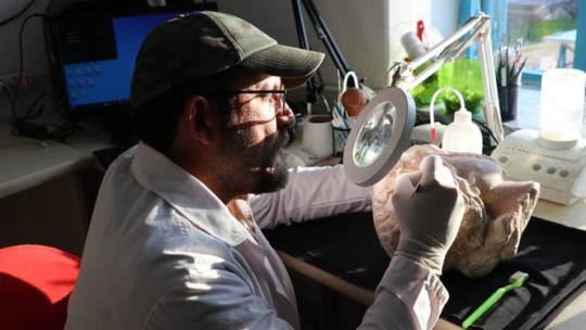
"The most exciting development for us this season is uncovering new heads of the goddess of love and beauty, Aphrodite, and the deity of wine Dionysus," Coskun said.
"In the excavation works we have conducted in the region so far, we have unearthed more than 100 statue pieces. Some of the heads found are from statues that are 2-3 meters long," he noted.
"These statue heads, which we first discovered three years ago, are in very well-preserved condition. During our excavations, so far we have discovered two Aphrodite and three Dionysus statue heads," Coskun said.
The excavation season, which began in the ancient city last April, will be completed by the end of this month, Coskun added.
#Turkish Archaeologists Unearth Sculpted Heads of Ancient Greek Deities#ancient city of Aizanoi#Dionysus#Aphrodite#marble#marble statue#marble sculpture#marble head#ancient artifacts#archeology#archeolgst#history#history news#ancient history#ancient culture#ancient civilizations#greek history#roman history#greek art#roman art
294 notes
·
View notes
Text
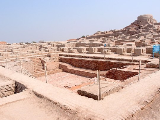
Excavated ruins of Mohenjo-daro of the Indus Valley Civilization, Sindh province, Pakistan, showing the Great Bath in the foreground. Mohenjo-daro, on the right bank of the Indus River, is a UNESCO World Heritage Site, the first site in South Asia to be so declared.
257 notes
·
View notes
Text


La Pedrera. Photos from Ajuntament de Barcelona and La Pedrera.
Nowadays, la Pedrera is one of the most famous building in Barcelona, Catalonia. It's one of the most emblematic buildings in the Catalan Modernism style, and has been declared part of the UNESCO World Heritage Site "Works of Antoni Gaudí".
But it hasn't always been recognised as good architecture, all the opposite! In fact, take a look at its name: it's technically called Casa Milà (house of the Milà family), but locals always call it "la Pedrera", which means "the quarry" in the Catalan language. When it was built, in 1910, Barcelonians thought it looked like an ugly piece of stone-y quarry mountain in the middle of the city.
But that's not the only thing that they thought it looked like. Let's see some parodies that were published at the time:

In 1909, the popular magazine Cu-Cut! published this vignette of a mother and a son walking in front of the house, when the child asks his mom "was there also an earthquake here?". This is a reference to an earthquake that happened in Sicily the previous month, and to the house's bendy shapes that look like it was shaken.

In 1925, the children's magazine En Patufet also joined in, with a vignette where the owner realises he can't hang up curtains* on this windows.
*Note: I'm using the translation "curtains" as a simplification so that English speakers without a detailed knowledge of Catalan culture can understand the joke. The vignette actually uses the word "domàs", meaning a decorative textile that is hanged from balconies during holidays.

In 1910, Cu-cut! compared it to a mona, the cake that Catalans eat on Easter Monday, by drawing a vignette where a child says "Daddy, daddy, I want a mona as big as this one!".

Three times did the magazine El Diluvio mock this building.
First, in 1910, they called it a "Medieval architecture model, between burrow and burial, that I don't quite dislike". It described its future in the following way: "the round gaps in the façade have become dark holes where all kinds of vermin come in and out: crocodiles and rats, but also snakes, hedgehogs, owls, sea monsters... Two undulating lines wrap up the building, which stands in front of an absolutely black sky. Above it, in the rooftop, the chimneys, the air vents and the stairs' endings have stopped being whipped cream mountains to become sinister piles of skulls."
In 1911, El Diluvio striked again, comparing the building's cast iron handrails to a fish stand. Their illustration had Casa Milà with a sign saying "cod entrails sold here!".
And lastly, it made fun of the controversial statue of Our Lady of the Rosary that was supposed to go on top. The Milà family in the end decided not to place the statue (some say because they didn't like how the sculptor made it, some say it's because they were scared of having a religious symbol after the 1909 anti-clerical riots) but the architect Gaudí, who was a very religious man, insisted on having it. This caused the Milàs and Gaudí to argue, which the magazine represents with a caricature of Mr. Milà wearing a Tarzan-like loincloth and branding a whip fighting against Gaudí wearing a pith helmet, grabbing him by the hair and hitting him with a hammer. The text under the image translates to "Will the Virgin Mary stand on top of the peculiar monument? Who will win, Gaudí or Milà?".
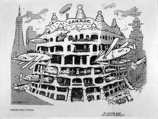
In 1912, the popular magazine L'Esquella de la Torratxa imagined that this extravagant futuristic building could only be a garage for parking airship and air-planes. This satirical drawing is titled "Future Barcelona. The true destiny of the Milà and Pi house". (Milà and Pi were the owners of this building).
The text that accompanied this illustration wondered if this building is the Wagnerian Valhalla, an anti-aircraft defense for the Moroccan War, or a hangar for zeppelins.
What do you think? Was the banter justified?
#la pedrera#casa milà#barcelona#catalunya#història#arquitectura#arts#history#architecture#antoni gaudí#gaudí#unesco world heritage#world heritage#historical#history tag#art history#art#modernisme#travel
177 notes
·
View notes
Text

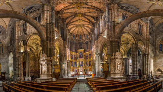
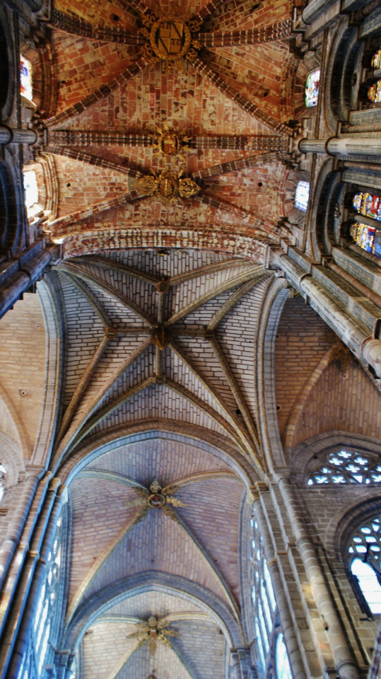


Cathedral of Christ the Savior, Ávila, was the first Gothic cathedral in Spain. It was built within the walls in the upper area of the city as a temple and fortress. Begun in 1160 in Romanesque style, it soon evolved into Gothic at the hands of Giral Fruchel, senior master of works of French origin. In this magnificent cathedral, touches of Renaissance and Baroque can also be distinguished, for example, on its western façade.
In 1985, UNESCO declared it a World Heritage Site.
162 notes
·
View notes
Text
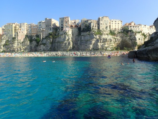
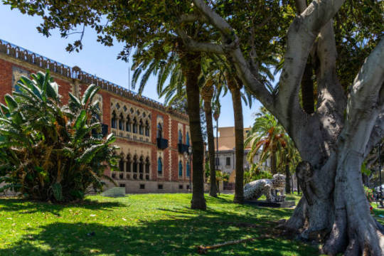
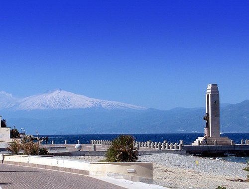
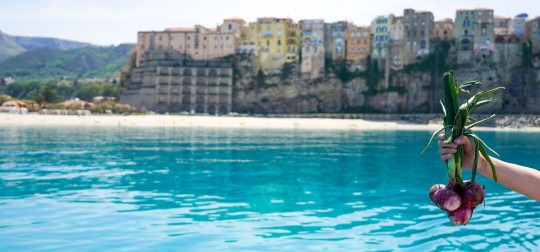
Calabria, the toe of southern Italy is one of the country’s least-known regions and probably the most underrated one.
Calabria is best known for its beautiful sandy beaches along the Tyrrhenian and the Ionian Sea, and its dramatic cliffs, coves, and rock formations: 800 km of coastline, stunning turquoise waters and green hills adorned with olive, orange, and lemon trees.
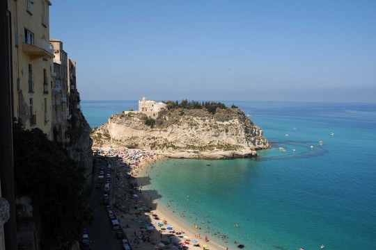
The heart of the region offers a pure and unspoiled scenery, comprised of thick forests, dotted with canyons, streams, and waterfalls and three national parks: Aspromonte, Pollino (UNESCO heritage site), and Sila.
The warm weather, the wild and mysterious nature, the strong and genuine flavors of local food and the vestiges of its ancient origins, when it was a colony of Greece, make Calabria an ideal destination all year around, without the long-haul flights of more exotic destinations.
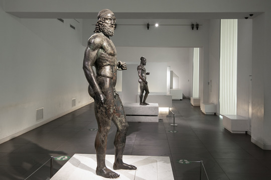
Art lovers cannot miss the famous Riace bronzes, that were found in the Ionian Sea near Riace in 1972 and exhibited in the National Museum of Reggio Calabria. These beautiful statues, probably two warrior heroes larger than life-size, are a fine example of classical Greek sculpture.
Reggio's ancient history predates the Greeks, who settled this strategic location at the exact center of the Mediterranean in the 8th century BC. They called their colony Rhegion, which was subsequently Latinized by the Romans and transformed through the ages under the area’s various rulers.
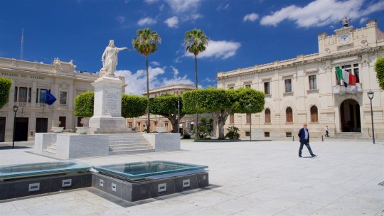
In Reggio Calabria, the lungomare or waterfront is a great place for a stroll, either down at beach level or along the upper promenade, which flanks what is commonly referred to as Via Marina, a pair of north-south coastal roads laid out in boulevard style. The approximate two-kilometer strip of land between serves as a lovely city park the length of the downtown area.
Stately mansions face this public garden and the strait beyond.
The seafront elegant, panoramic promenade lined with palm trees, with its views across the Messina Strait, which divides the Italian peninsula from the island of Sicily, to Mt Etna is one of the most atmospheric places for a walk.
Capo Vaticano is considered one of the 100 most beautiful beaches in the world: a long beach of fine sand with crystal clear waters, surrounded by ancient trees.
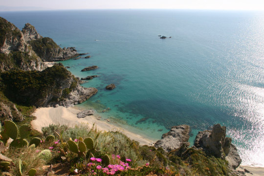
Tropea, a puzzle of lanes and piazzas, is one of Calabria’s most attractive towns. It is set in a dramatic spot on a cliff where the houses seem to blend into the rock. Tropea is famed for the spectacular sunsets, between the cliff and the rocky promontory with the church of Santa Maria dell’Isola.
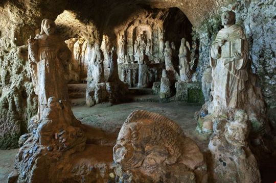
Stacked high up on a sea cliff, there is Pizzo with its unique Church of Piedigrotta, entirely carved out of tuff stone.
Chili pepper, ‘nduja and Tropea onions are the first ingredients that come to mind when talking about Calabrese cuisine.
Calabrians love chilli peppers and they add it in everything, from pasta to ice-cream! Every September, the “peperoncino” festival takes place in Diamante to celebrate its locally produced food.
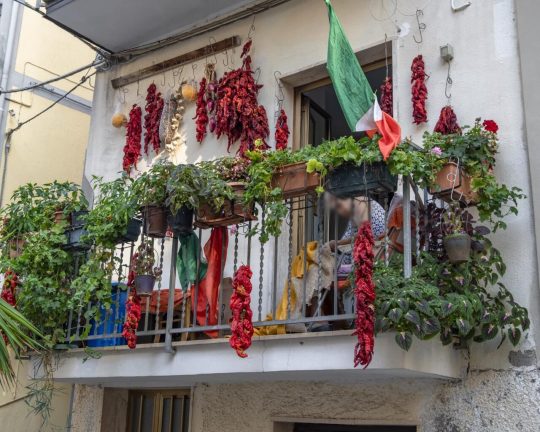
‘Nduja is the Calabrian version of salami. A spicy, spreadable cold cut with chilli peppers (of course) and spices.
Tropea’s red onion is known for its mild, sweet flavour. In fact, these onions are so famous that cipolla di Tropea has become a Calabrian symbol.
Follow us on Instagram, @calabria_mediterranea
#calabria#italy#italia#south italy#southern italy#mediterranean#italian#tropea#reggio calabria#red onion#chili peppers#chili pepper#chili#ancient art#ancient#history#ancient history#bronzi di riace#riace bronzes#magna graecia#greek#greek art#sculptures#bronze#landscape#europe#italian landscape#italian landscapes#landscapes
132 notes
·
View notes
Text
Ach-To and Irish Archaeology
The sequels were my entry into Star Wars and I never would have gone to see The Force Awakens if I wasn't an archaeology nerd.
During the production of Episode VII, a decent number of people with an interest in our archaeological heritage here in Ireland were quite worried about the impact of filming on one of our only two UNESCO World Heritage Sites, the island known as Skellig Michael down off the coast of Kerry.
I went to the film to see if any potential damage was worth it, or if they'd do something unspeakably stupid with it in-universe. I wanted to see if it was respected.
And holy hell I was NOT disappointed. I think I walked out of TFA sniffling to myself about how beautiful the Skellig looked and how it seemed like its use as a location was not just respectful but heavily inspired by its real history.
See, Skellig Michael was a monastic hermitage established at a point when Christianity was so new that the man who ordered its founding sometime in the first century CE was himself ordained by the Apostle Paul. The fellah from the Bible who harassed all and sundry with his letters, THAT Apostle Paul. This is how old a Christian site the Skellig is. It predates St. Patrick by at the very least two hundred years.
The steps we watch Rey climb were originally cut NEARLY TWO THOUSAND YEARS AGO. They have been reworked and repaired many many times since, of course. Still, the path the camera follows Daisy Ridley up is as much an ancient path built by the founders of a faith in real life as it is in the movies.
A hermitage was a place where monks went to live lives of solitude and asceticism so as better to achieve wisdom. The practice is common to many of the major world religions, including the myriad East Asian faiths which inspired the fictional Jedi.
It is said that the hermitage and monastery were originally built with the purpose of housing mystical texts belonging to the Essanes, one of the sects of Second Temple Judaism which influenced some of the doctrines of Christianity. They also, according to what I have read, characterised good and evil as 'light' and 'darkness' and were celibate.
As such, the use of the island in TFA and TLJ does not merely respect Skellig Michael's history, it honours it. It is framed as somewhere ancient and sacred, which it is. It is framed as a place where a mystic goes to live on his own surrounded by nature that is at once punishing and sublime, which of course it was. It shown to be a place established to protect texts written at the establishment of a faith, which it may well have been.
This level of genuine respect for my cultural heritage by Rian Johnson in particular is astonishing. I don't think anyone from outside the US ever really trusts Americans not to treat our built history like it's Disneyland. Much of the incorporation of the Skellig's real past into a fictional galactic history occurs in TLJ, which is why I'm giving Rian so much credit.
It's Luke's death scene which makes the honouring of Irish archaeological history most apparent though.
Johnson takes the archaeological iconography back a further three thousand years for his final tribute to my culture's beautiful historical temples. This time, he incorporates neolithic passage tomb imagery, specifically that of Newgrange, which is up the country from the Skellig.
I think if you understand what the image represents then it makes a deeply emotional scene even more resonant.
The scene I'm referring to is Luke's death.
As he looks to the horizon, to the suns, we view him from the interior of the First Jedi Temple. The sunset aligns with the passageway into the ancient sanctuary, illuminating it as he becomes one with the Force.
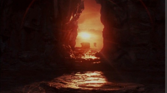
As for Newgrange, every year during the Winter Solstice it aligns with the sunrise. The coldest, darkest, wettest, most miserable time of the year on a North Atlantic island where it is often cold, wet, and miserable even in the summer. And the sun comes up even then, and on a cloudless morning a beam of sunlight travels down the corridor and illuminates the chamber inside the mound.
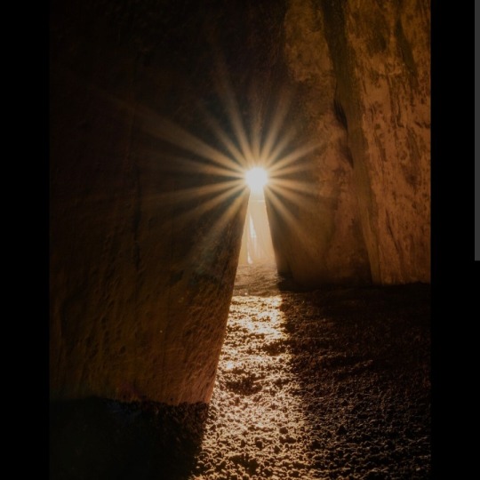
You guys can see this, right? The similarity of the images? The line of light on the floor?
Luke's death scene is beautiful but I think it's a thousand times more moving with this visual context. Luke's sequel arc isn't merely populated by a lore and iconography that honour the place where the end of his story was filmed, I think that incorporation of that history and mythology honours Luke.
We don't know for sure what the Neolithic people believed, religion-wise. We know next to nothing about their rituals. We know that there were ashes laid to rest at Newgrange. There is some speculation that the idea was that the sun coming into the place that kept those ashes brought the spirits of those deceased people over to the other side.
It's also almost impossible not to interpret the sunlight coming into Newgrange as an extraordinary expression of hope. If you know this climate, at this latitude, you know how horrible the winter is. We don't even have the benefit of crispy-snowwy sunlit days. It's grey and it's dark and it's often wet. And every single year the earth tilts back and the days get long again.
The cycle ends and begins again. Death and rebirth. And hope, like the sun, which though unseen will always return. And so we make it through the winter, and through the night.
As it transpired the worries about the impact of the Star Wars Sequels upon Skellig Michael were unfounded. There was no damage caused that visitors wouldn't have also caused. There also wasn't a large uptick in people wanting to visit because of its status as a SW location, in part I think because the sequels just aren't that beloved.
But they're beloved to me, in no small part because of the way they treated a built heritage very dear to my heart. I think they deserve respect for that at the least.
#star wars meta#ach-to#irish history#Irish Archaeology#first jedi temple#skellig michael#newgrange#luke skywalker#the last jedi#early christianity#neolithic#historical parallels in star wars#star wars and history#star wars and mythology#star wars and archaeology
128 notes
·
View notes
Photo

History & Mining Culture of the Ore Mountains
The Ore Mountains (Erzgebirge) on the border between Germany and the Czech Republic is a region rich in history and culture connected to the mining industry. For centuries the cities on both sides of the mountain range had sustained themselves and flourished by the extraction of tin, copper, zinc, uranium, and most importantly silver. Even though the mines are now closed the mining culture and heritage is still widely celebrated and visible for visitors, with the hammer and chisel motif on many buildings in the different mining towns.
The rich mining heritage of the region was recently inscribed on the UNESCO world heritage list (July 2019 CE), with sites on both sides of the border. On the German side, in the Free State of Saxony, the cities of Freiberg and Annaberg-Buchholz has much to offer in educating visitors about the mining industry, both from the Middle Ages and more recent times and how this intensive industry shaped the lives and culture of the people living there. A visit is definitely recommended for anyone interested in mining history, early industrialization or for those who seek to experience an authentic German Christmas market.
Freiberg
Freiberg, a one-hour train ride from Dresden, traces its history back to 1168 CE. At that time the forest region was under the control of the Margrave of Meissen. A silver ore was discovered close to the small settlement Christiandorf and lead to the establishment of the city of Freiberg, which got its name from the mining rights belonging to the “free miner”. The mining industry became a very important source of income for the Margrave of Meissen, Otto II (r. c. 1156-1190 CE), known later as Otto the Rich. A large statue of the town's 'founder' can now be seen at the main square of the historic city center. Freiberg's importance and wealth increased rapidly after the discovery of silver, and it remained the economic center and mint of Saxony until the 16th century CE. The mining industry continued in the Freiberg region for 800 years until the mines were finally closed in 1968 CE.
Today Freiberg is a lively and charming city with many exciting sites to see, amongst other the Town Hall from the 15th century CE, and the Cathedral of St. Mary, first contracted in 1180 CE as a Romanesque basilica, the current building dates to c. 1500 CE. On the south side of the cathedral, you can visit a part of the old church, The Golden Gate, a richly ornamented sandstone portal from 1230 CE.
Even though the town was destroyed by fire several times and suffered during the Thirty Years' War (1618-1648 CE), much of the medieval town is still standing. Walking around in the historic center, one architectural feature is especially remarkable: the Gothic patrician houses with very high and steep pitched roof constructions. The main square, Obermakt, is definitely worth a visit, where you will see both the statue of Otto the Rich and the beautiful Town Hall. On the north side of the square, you can also marvel at a gate with intricate carvings depicturing the miners hard at work.
It is impossible to visit this city without being drawn towards the rich mining history and culture. To learn more, visitors are recommended to spend a couple of hours in the Freiberg City and Mining Museum. Located in a stunning late Gothic building, it is one of Saxony's oldest museums, established in 1861 CE. The museum is filled with tools, art, photographs, and other objects connected to work in the mines throughout the ages or the culture that flourished thanks to the mining industry. In addition, no one should leave without a visit to the Freudenstein Castle, where the mineral exhibition Terra Mineralia is on display with over 3,500 minerals, precious stones, and meteorites. The exhibition is presented by the Technical University Bergakademie Freiberg, the oldest university of mining and metallurgy in the world, and is a real treasure trove filled with gems from all over the world.
Continue reading...
29 notes
·
View notes
Text
Story and photographs by Ronan O’Connell
September 26, 2023
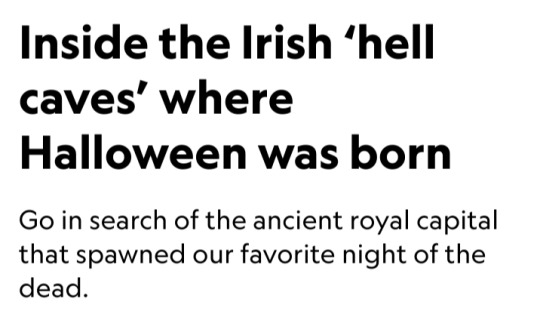
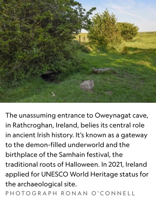
In the middle of a field in a lesser known part of Ireland is a large mound where sheep wander and graze freely.
Had they been in that same location centuries ago, these animals might have been stiff with terror, held aloft by chanting, costumed celebrants while being sacrificed to demonic spirits that were said to inhabit nearby Oweynagat cave.
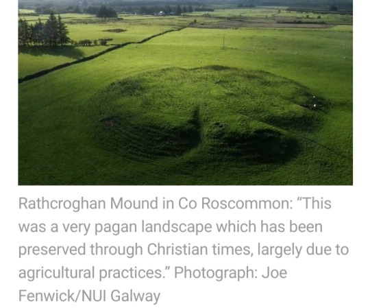
This monumental mound lay at the heart of Rathcroghan, the hub of the ancient Irish kingdom of Connaught.
The former Iron Age center is now largely buried beneath the farmland of County Roscommon.
In 2021, Ireland applied for UNESCO World Heritage status for Rathcroghan (Rath-craw-hin). It remains on the organization's tentative list.

Rooted in lore
Spread across more than two square miles of rich agricultural land, Rathcroghan encompasses 240 archaeological sites, dating back 5,500 years.
They include burial mounds, ring forts (settlement sites), standing stones, linear earthworks, an Iron Age ritual sanctuary — and Oweynagat, the so-called gate to hell.
More than 2,000 years ago, when Ireland’s communities seem to have worshipped nature and the land itself, it was here at Rathcroghan that the Irish New Year festival of Samhain (SOW-in) was born, says archaeologist and Rathcroghan expert Daniel Curley.
In the 1800s, the Samhain tradition was brought by Irish immigrants to the United States, where it morphed into the sugar overload that is American Halloween.
Dorothy Ann Bray, a retired associate professor at McGill University and an expert in Irish folklore, explains that pre-Christian Irish divided each year into summer and winter.
Within that framework were four festivities.
Imbolc, on February 1, was a festival that coincided with lambing season.
Bealtaine, on May 1, marked the end of winter and involved customs like washing one’s face in dew, plucking the first blooming flowers, and dancing around a decorated tree.
August 1 heralded Lughnasadh, a harvest festival dedicated to the god Lugh and presided over by Irish kings.
Then on October 31 came Samhain, when one pastoral year ended and another began.
Rathcroghan was not a town, as Connaught had no proper urban centers and consisted of scattered rural properties.
Instead, it was a royal settlement and a key venue for these festivals.
During Samhain, in particular, Rathcroghan was a hive of activity focused on its elevated temple, which was surrounded by burial grounds for the Connachta elite.
Those same privileged people may have lived at Rathcroghan. The remaining lower-class Connachta communities resided in dispersed farms and descended on the site only for festivals.
At those lively events they traded, feasted, exchanged gifts, played games, arranged marriages, and announced declarations of war or peace.
Festivalgoers also may have made ritual offerings, possibly directed to the spirits of Ireland’s otherworld.
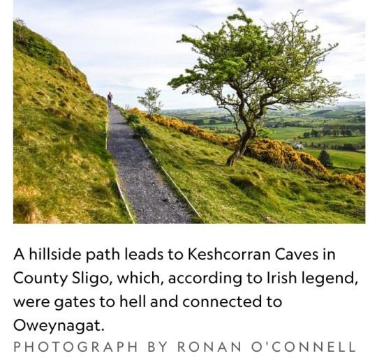
That murky, subterranean dimension, also known as Tír na nÓg (Teer-na-nohg), was inhabited by Ireland’s immortals, as well as a myriad of beasts, demons, and monsters.
During Samhain, some of these creatures escaped via Oweynagat cave (pronounced “Oen-na-gat” and meaning “cave of the cats”).
“Samhain was when the invisible wall between the living world and the otherworld disappeared,” says Mike McCarthy, a Rathcroghan tour guide and researcher who has co-authored several publications on the site.
“A whole host of fearsome otherworldly beasts emerged to ravage the surrounding landscape and make it ready for winter.”
Thankful for the agricultural efforts of these spirits but wary of falling victim to their fury, the people protected themselves from physical harm by lighting ritual fires on hilltops and in fields.
They disguised themselves as fellow ghouls, McCarthy says, so as not to be dragged into the otherworld via the cave.
Despite these engaging legends — and the extensive archaeological site in which they dwell — one easily could drive past Rathcroghan and spot nothing but paddocks.
Inhabited for more than 10,000 years, Ireland is so dense with historical remains that many are either largely or entirely unnoticed.
Some are hidden beneath the ground, having been abandoned centuries ago and then slowly consumed by nature.
That includes Rathcroghan, which some experts say may be Europe’s largest unexcavated royal complex.
Not only has it never been dug up, but it also predates Ireland’s written history.
That means scientists must piece together its tale using non-invasive technology and artifacts found in its vicinity.
While Irish people for centuries knew this site was home to Rathcroghan, it wasn’t until the 1990s that a team of Irish researchers used remote sensing technology to reveal its archaeological secrets beneath the ground.
“The beauty of the approach to date at Rathcroghan is that so much has been uncovered without the destruction that comes with excavating upstanding earthwork monuments,” Curley says.
“[Now] targeted excavation can be engaged with, which will answer our research questions while limiting the damage inherent with excavation.”
Becoming a UNESCO site
This policy of preserving Rathcroghan’s integrity and authenticity extends to tourism.
Despite its significance, Rathcroghan is one of Ireland’s less frequented attractions, drawing some 22,000 visitors a year compared with more than a million at the Cliffs of Moher.
That may not be the case had it long ago been heavily marketed as the “Birthplace of Halloween,” Curley says.
But there is no Halloween signage at Rathcroghan or in Tulsk, the nearest town.
Rathcroghan’s renown should soar, however, if Ireland is successful in its push to make it a UNESCO World Heritage site.
The Irish Government has included Rathcroghan as part of the “Royal Sites of Ireland,” which is on its newest list of locations to be considered for prized World Heritage status.
The global exposure potentially offered by UNESCO branding would likely attract many more visitors to Rathcroghan.
But it seems unlikely this historic jewel will be re-packaged as a kitschy Halloween tourist attraction.
“If Rathcroghan got a UNESCO listing and that attracted more attention here that would be great, because it might result in more funding to look after the site,” Curley says.
“But we want sustainable tourism, not a rush of gimmicky Halloween tourism.”
Those travelers who do seek out Rathcroghan might have trouble finding Oweynagat cave.
Oweynagat is elusive — despite being the birthplace of Medb, perhaps the most famous queen in Irish history, 2,000 years ago.
Barely signposted, it’s hidden beneath trees in a paddock at the end of a one-way, dead-end farm track, about a thousand yards south of the much more accessible temple mound.
Visitors are free to hop a fence, walk through a field, and peer into the narrow passage of Oweynagat.
In Ireland’s Iron Age, such behavior would have been enormously risky during Samhain, when even wearing a ghastly disguise might not have spared the wrath of a malevolent creature.
Two millennia later, most costumed trick-or-treaters on Halloween won’t realize they’re mimicking a prehistoric tradition — one with much higher stakes than the pursuit of candy.
#Rathcroghan#Connaught#County Roscommon#UNESCO World Heritage#Samhain#Imbolc#Bealtaine#Lughnasadh#Tír na nÓg#Oweynagat cave#Ireland#remote sensing technology#Birthplace of Halloween#Halloween#Royal Sites of Ireland#Halloween tourism#Medb#Oweynagat#Iron Age#Irish history#archaeological site
84 notes
·
View notes
Text

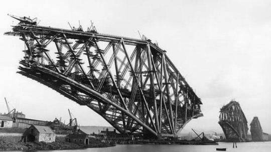
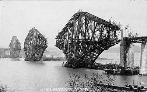


4th March 1890 saw the opening of the Forth Rail Bridge or to give it the correct title The Forth Bridge.
Before 1890 the only direct route between Queensferry and North Queensferry in the east of Scotland was the ferry across the Firth of Forth. The crossing was slow and often dangerous and the four ferries, Queen Margaret, Robert the Bruce, Mary Queen of Scots and Sir William Wallace, were sometimes prevented from sailing by the weather.
When the railways arrived a ferry further downstream, from Granton to Burntisland, was used to transport goods from Edinburgh to Fife. But a more efficient means of crossing was required and so Thomas Bouch designed a suspension bridge.
Work started on the first pier at Inchgarvie but it was abandoned after another structure by Bouch of a similar design, the Tay Bridge, collapsed in 1879. A new design by John Fowler and Benjamin Baker, incorporating three double cantilevers, was commissioned and work commenced in 1883.
Over the course of the next seven years almost 51,000 Tons of steel was used in the construction of the Forth Bridge (or Forth Rail Bridge as it is often known). On 4 March 1890 the bridge was officially opened by the Prince of Wales (later King Edward VII) who drove in the last of the 6,500,000 rivets. The total cost of the project was £3,200,000 and at least 57 lives.
Three 100m tall towers support the 2.5km structure and the two track railway is carried at a height of 48.2m above the Firth of Forth. With main spans of 521m, the Forth Bridge was, at the time of its construction, the world’s largest cantilever bridge. To this day it still ranks second.
Last year the bridge became the sixth Scottish landmark to be awarded Unesco World Heritage Site status.Scotland's other World Heritage Sites are New Lanark, St Kilda, the Old and New Towns in Edinburgh, Neolithic Orkney and the Antonine Wall.
The award puts it alongside the Pyramids of Egypt, the great Wall of China and the Sydney Opera House in terms of cultural significance.
40 notes
·
View notes
Text
What does it mean to erase a people – a nation, culture, identity? In Gaza, we are beginning to find out
“Earlier this month, Gaza’s oldest mosque was destroyed by Israeli airstrikes. The Omari mosque was originally a fifth century Byzantine church, and was an iconic landmark of Gaza: 44,000 sq ft of history, architecture and cultural heritage. But it was also a live site of contemporary practice and worship. A 45-year-old Gazan told Reuters that he had been ‘praying there and playing around it all through my childhood‘. Israel, he said, is ‘trying to wipe out our memories’.
“St Porphyrius church, the oldest in Gaza, also dating back to the fifth century and believed to be the third oldest church in the world, was damaged in another strike in October. It was sheltering displaced people, among them members of the oldest Christian community in the world, one that dates back to the first century. So far, more than 100 heritage sites in Gaza have been damaged or levelled. Among them are a 2,000-year-old Roman cemetery and the Rafah Museum, which was dedicated to the region’s long and mixed religious and architectural heritage.
“As the past is being uprooted, the future is also being curtailed. The Islamic University of Gaza, the first higher education institution established in the Gaza Strip in 1978, and which trains, among others, Gaza’s doctors and engineers, has been destroyed, along with more than 200 schools. Sufian Tayeh, the rector of the university, was killed along with his family in an airstrike. He was the Unesco chair of physical, astrophysical and space sciences in Palestine. Other high-profile academics who have been killed include the microbiologist Dr Muhammad Eid Shabir, and the prominent poet and writer Dr Refaat Alareer, whose poem, If I must die, was widely shared after his death ...
“As the ability to tell these stories publicly comes under attack, so do the private rituals of mourning and memorialisation. According to a New York Times investigation, Israel ground forces are bulldozing cemeteries in their advance on the Gaza Strip, destroying at least six. Ahmed Masoud, a British Palestinian writer from Gaza, posted a picture of him visiting his father’s grave, alongside a video of its ruins. ‘This is the graveyard in Jabalia camp,’ he wrote, where his father was buried. ‘I went to visit him in May. The Israeli tanks have now destroyed it, and my dad’s grave has gone. I won’t be able to visit or talk to him again.’
“A memory gap is forming. Libraries and museums are being levelled, and what is lost in the documents that have burned joins a larger toll of record-keeping. Meanwhile, the scale of the killings is so large that entire extended families are disappearing. The result is like tearing pages out of a book. Dina Matar, a professor at Soas University of London, told the Financial Times that ‘such loss results in the erasure of shared memories and identities for those who survive. Remembering matters. These are important elements when you want to put together histories and stories of ordinary lives’ ...
“This is what it would look like, to erase a people. In short, to void the architecture of belonging that we all take so much for granted so that, no matter how many Gazans survive, there is, over time, less and less to bind them together into a valid whole. This is what it would look like, when you deprive them of telling their story, of producing their art, of sharing in music, song and poetry, and of a foundational history that lives in their landmarks, mosques, churches, and even in their graves.”
#omari mosque#st porphyrius church#islamic university of gaza#free gaza#free palestine#from the river to the sea#religion#education#art#culture#journalism#occupation of palestine#israeli occupation#ethnic cleansing#genocide#israeli war crimes#war crimes#gaza#palestine#israel#middle east
43 notes
·
View notes
Last Seen Blogs

vintagebaby
vintage

viozzu
Viozzu


ravenconga21
İsimsiz

realtimefanduboutofcontext
Real-Time Fandub Out of Context