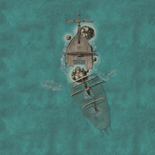
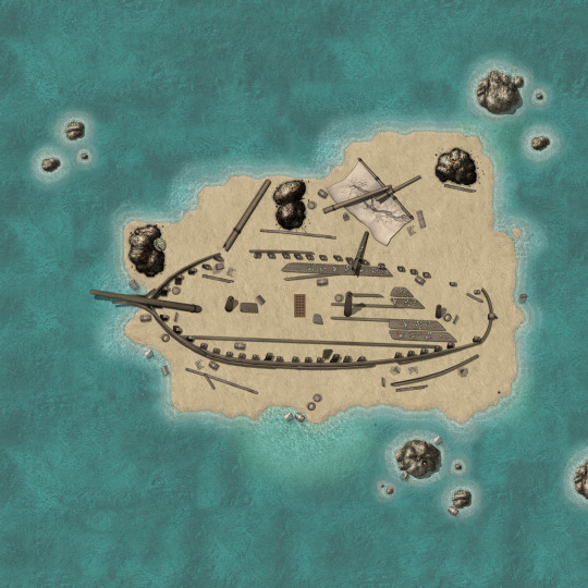
#shipwreck map
Text
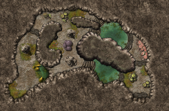

Shipwreck Cave
Cave: 3500x2310
Shipwreck: 3500x3500
#Dungeons & Dragons#Dungeons and Dragons#D&D#DND#5e#5th edition#d&d 5th edition#map#maps#cavern map#cave map#island map#shipwreck#shipwreck map#roll20#ttrpg#rpg#vtt#Dungeon Master#DM#homebrew#homebrew 5e#roleplaying
14 notes
·
View notes
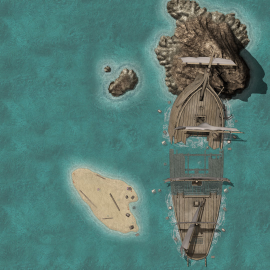
Photo
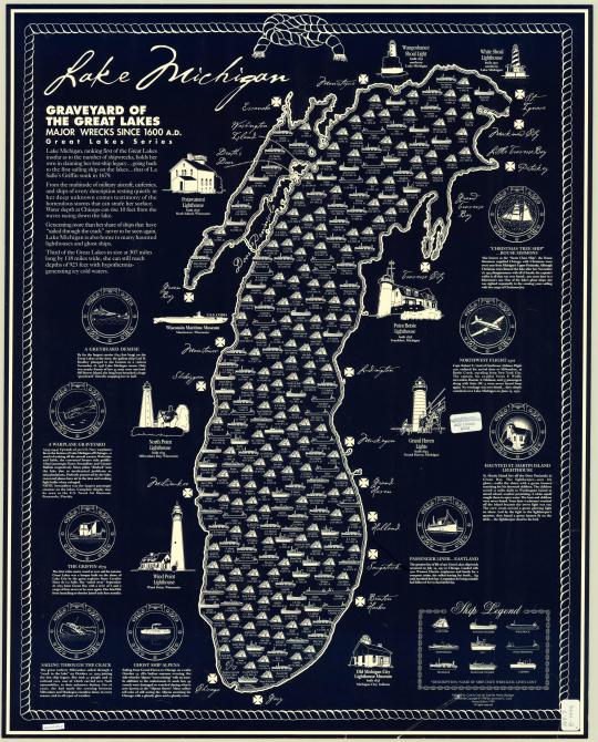
Lake Michigan Shipwrecks
234 notes
·
View notes
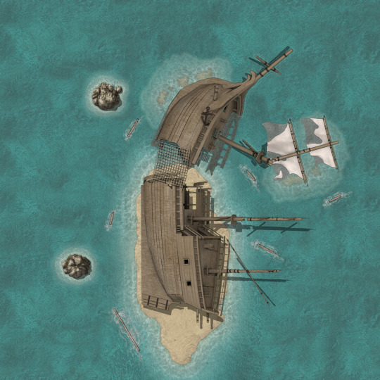
Photo

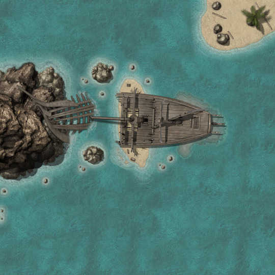
The Pirate's Grotto Battle Map (32x44)
You've entered the Pirate's Grotto, a 32x44 sea cave occupied by a wrecked ship, its pirate crew, and their treasures. Make a Stealth roll...
→ The Pirate’s Grotto Battle Map
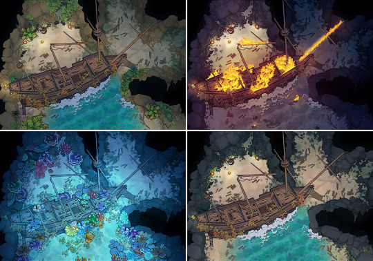
A huge 32×44 battle map of a tropical sea cave and a wrecked pirate ship. There’s treasure to be had… If you can overcome the scavengers.
Connor Johnston (of CocosTreasuryOfTokens) is the captain behind this map pack, carefully decorating the cliffs and beaches of this cave to bring you a wonderful self-contained encounter map.
Behind the shipwreck can be seen the firelight casting wicked shadows high upon the cave walls. Who might await your adventurers back there? Is it the pirates stranded by this misfortune? Looters, salvagers? And who knows what might be swimming about…
Find the downloads here:
https://2minutetabletop.com/pirates-grove-battle-map/
Hope you enjoy this one, and I’d love to hear about the encounters you cook up. 🙂
Happy swashbuckling,
– Ross
#ttrpg#tabletop#dungeons and dragons#dnd#dungeons & dragons#d&d#d&d5e#dnd5e#pathfinder#gurps#rpg#top-down#battle map#map#cartography#encounter#geomorph#pirates#shipwreck#dungeon#cave
1K notes
·
View notes
Text
buckys quivering in the barrel while im scrolling through tumblr bc im too scared to leave the bucket
#shipwrecked 64#YALL THE LAST TIME I DID THAT I DIDNT HEAR ANYTHING#BUT WALTER JUMPED ME FROM ACROSS THE MAP#i survived tho so
9 notes
·
View notes
Note
How bout a leopard seal, elk?

#those suggestions must be 1 year old now ahahaha#gaul-the-unmitigated#suggestion#shipwrecker#sea creature#i want it to be a reccurent theme now ! like in those old school maps#also wanted to do some cold climate monsters this one fit in both#seal#leopard seal#antlers#elk#the Unknown#chimera#monster#creature design#bestiary#ink#850#octem 107#terra 4
232 notes
·
View notes
Text


Headless lines that make me laugh every single time 9/???
#brom bones#ichabod crane#headless#ichabod fully shaking his head at You know google maps?#he’s a bingman Brom#shipwrecked#gabe greenspan#sean persaud#Brom my sweet boy you’re both millenials you know what maps are
133 notes
·
View notes
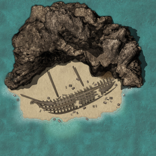
Photo
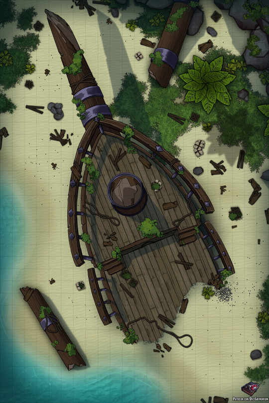
Greetings!
Three weeks ago, the adventurers set sail to embark on a quest full of adventure, rum and lots of loot. Everything was going well, and despite the age of their vessel, they quickly sailed the seas in search for gold.
Until one fateful night, when a storm of epic proportions hit their ship hard. Despite the skillful maneuvers of the captain, the vessel was torn apart.
No one really knows how they all managed to survive and stick together through that terrible ordeal, but they did.
Now stranded and without ship, they now press forward to recover what was taken from them by the Gods.
You can see a preview of this map’s Patreon content by clicking here.
If you liked the map I’d be extremely thankful if you considered supporting me on my Patreon, rewards include higher resolution files, gridless versions, alternate versions, line versions, PSDs and more. Thank you!
166 notes
·
View notes
Text
Titanic: First ever full-sized scans reveal wreck as never seen before

Titanic departing Southampton on 10 April 1912
By Rebecca Morelle and Alison Francis
BBC News Climate and Science
17 May 2023
The world's most famous shipwreck has been revealed as never seen before.
The first full-sized digital scan of the Titanic, which lies 3,800m (12,500ft) down in the Atlantic, has been created using deep-sea mapping.
It provides a unique 3D view of the entire ship, enabling it to be seen as if the water has been drained away.
The hope is that this will shed new light on exactly what happened to the liner, which sank on 15 April 1912.
More than 1,500 people died when the ship struck an iceberg on its maiden voyage from Southampton to New York.
"There are still questions, basic questions, that need to be answered about the ship," Parks Stephenson, a Titanic analyst, told BBC News.
He said the model was "one of the first major steps to driving the Titanic story towards evidence-based research - and not speculation."
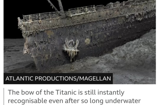
The Titanic has been extensively explored since the wreck was discovered in 1985.
But it's so huge that in the gloom of the deep, cameras can only ever show us tantalizing snapshots of the decaying ship - never the whole thing.
The new scan captures the wreck in its entirety, revealing a complete view of the Titanic.
It lies in two parts, with the bow and the stern separated by about 800m (2,600ft). A huge debris field surrounds the broken vessel.
The scan was carried out in summer 2022 by Magellan Ltd, a deep-sea mapping company, and Atlantic Productions, who are making a documentary about the project.
Submersibles, remotely controlled by a team on board a specialist ship, spent more than 200 hours surveying the length and breadth of the wreck.
They took more than 700,000 images from every angle, creating an exact 3D reconstruction.
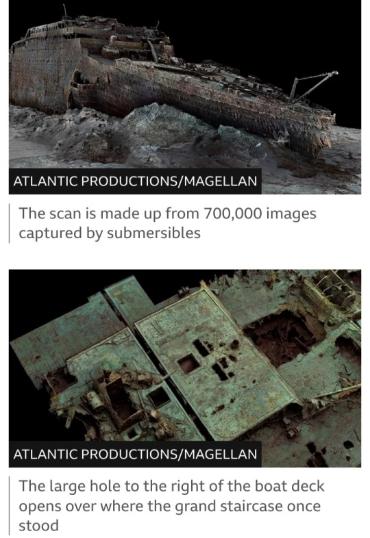
Magellan's Gerhard Seiffert, who led the planning for the expedition, said it was the largest underwater scanning project he'd ever undertaken.
"The depth of it, almost 4,000m, represents a challenge, and you have currents at the site, too - and we're not allowed to touch anything so as not to damage the wreck," he explained.
"And the other challenge is that you have to map every square centimetre - even uninteresting parts, like on the debris field you have to map mud, but you need this to fill in between all these interesting objects."
The scan shows both the scale of the ship, as well as some minute details, such as the serial number on one of the propellers.

The bow, now covered in stalactites of rust, is still instantly recognisable even 100 years after the ship was lost.
Sitting on top is the boat deck, where a gaping hole provides a glimpse into a void where the grand staircase once stood.
The stern though, is a chaotic mess of metal. This part of the ship collapsed as it corkscrewed into the sea floor.
In the surrounding debris field, items are scattered, including ornate metalwork from the ship, statues and unopened champagne bottles.
There are also personal possessions, including dozens of shoes resting on the sediment.

Parks Stephenson, who has studied the Titanic for many years, said he was "blown away" when he first saw the scans.
"It allows you to see the wreck as you can never see it from a submersible, and you can see the wreck in its entirety. You can see it in context and perspective. And what it's showing you now is the true state of the wreck."
He said that studying the scans could offer new insight into what happened to the Titanic on that fateful night of 1912.
"We really don't understand the character of the collision with the iceberg. We don't even know if she hit it along the starboard side, as is shown in all the movies - she might have grounded on the iceberg," he explained.
Studying the stern, he added, could reveal the mechanics of how the ship struck the sea floor.

The sea is taking its toll on the wreck, microbes are eating away at it and parts are disintegrating.
Historians are well aware that time is running out to fully understand the maritime disaster.
But the scan now freezes the wreck in time and will allow experts to pore over every tiny detail.
The hope is that the Titanic may yet give up its secrets.
#Titanic#shipwreck#deep-sea mapping#RMS Titanic#Magellan Ltd#Atlantic Productions#Gerhard Seiffert#Parks Stephenson#White Star Line#North Atlantic Ocean#15 April 1912#iceberg#digital scan#3D reconstruction
21 notes
·
View notes
Text

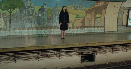
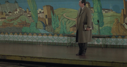

Últimas imágenes del naufragio / Last Images of the Shipwreck
Eliseo Subiela. 1989
Metro Station
Diagonal Norte, C1008 Buenos Aires, Argentina
See in map
See in imdb
#eliseo subiela#últimas imágenes del naufragio#last images of the shipwreck#lorenzo quinteros#noemí frenkel#mural#painted wall#martín s. noel#metro#underground#movie#cinema#film#location#google maps#street view#1989#buenos aires#argentina
6 notes
·
View notes
Text
Would u ppl like me posting about a new clangen clan I’ll make? Possibly with the occasional Art pieces, references, or sketches for the cats
If so um any ideas for them???
#I kinda want to do a more interesting clan yknow#like maybe one with the new shipwreck map#actually a poll would be so much cooler#kinda thinking about names. Depending on the cats I’ll decide what their basis is#like if they have a bloodthirsty or evil leader it’s more devious of a past while a kinder leader is more stable#ruse rambles#clangen#my clangen
10 notes
·
View notes
Text
6 Random Shipwreck Maps (3500x3500)
#Shipwreck#D&D#Dungeons & Dragons#DnD#Dungeons and Dragons#5e#map#maps#Dungeon Master#roll20#ttrpg#rpg#DM#homebrew#vtt#Dnd5e#Dungeons and Dragons 5e#5th edition#Dragons of Shipwreck Isle#DoSI#seamap#island map#ship map#ship wreck map
211 notes
·
View notes
Photo

Lake Superior Shipwrecks: known wrecks since 1800 A.D.
245 notes
·
View notes
Text
i really wish i could like the orr maps because they're delightfully creepy but the density of shipwrecks for, y'know, obvious reasons, is my worst phobia
i remember back when i first played GW2 and i was DETERMINED to get map comp, this was before stu played or i actively had friends i'd trust to log into my account to do shit like 'get that stupid shipwreck POI because i hate it'
pre DLCs when the orr champ runs were one of the best ways to get gold and loot and having to go to shipwreck rock to do rotbeard [in a shipwreck] and the megalodon [next to 2 shipwrecks] is a memory i would like to expell from my brain forever
i also remember being SO CLOSE to an achievement box tick over and deciding to do the mariner log plaques, then on the very last one finding out it was on the harbinger in orr, i damn near gave myself a panic attack out of sheer stupid determination trying to get that one
#i cannot deal with shipwrecks#regardless of how toony or realistic it is#something about them just activates every deep sense of 'absolutely not' in my body#i was so disappointed to see there was several wrecks on isle of reflection actually#they're so out of place looking and ruin the map
7 notes
·
View notes
Text
Uh oh! Local man becomes lost in the frozen wastes for days at a time with no map and no sense of direction!
#i lost some of my llamas…. and i managed to find my way to the castle and drop off what animals i had but then i got lost again#and found an underwater temple and shipwreck but didnt write down the coords bc bestie im panicking#those llamas had some VERY improtant items. like maps#sev rambles
3 notes
·
View notes
Photo


This 15x15 rocky beach is littered with the remains of a recent shipwreck. Powerful waves slowly wash flotsam ashore, littering the sand and rocks with unopened crates and barrels. At night, the tragic scene is illuminated by luminescent plankton in the waves.
Perhaps the PCs were part of the shipwreck, and find themselves stumbling ashore, or they happen upon the scene and find survivors or hostile scavengers.
Fullsize day/night versions are available on my Patreon, without watermark and with/without grid overlay.
6 notes
·
View notes
Photo
The Danger of Unbelief.—In one of the popular books of the present day there is a story told of “The Sunken Rock.” A vessel, named the Thetis, was cruising in the Mediterranean, in search of a shoal or bank, or something of that kind, said to exist beneath the treacherous waters. The captain, after he had adopted all the means he thought necessary, having failed, abandoned the enterprise, declaring “that the reported danger was all a dream.” An officer on board formed a different judgment, went out by himself on an expedition afterwards into the very same latitude and longitude, and there discovered a reef of rocks, which he reported to the Admiralty, and it was inserted in the charts, the discoverer being rewarded with a high appointment. The intelligence came to the captain’s ears; he would not believe in the discovery. He was a shrewd, clever, practical man, but unscientific, incredulous, and obstinate. “The whole thing is a falsehood,” he exclaimed; adding, “If ever I have the keel of the Thetis under me in those waters again, if I don’t carry her clean over where the chart marks a rock, call me a liar and no seaman.” Two years after, he was conveying in the same vessel the British Ambassador to Naples. One windy night he and the master were examining the chart on deck by the light of the lantern, when the latter pointed out the sunken rock on the map. “What!” exclaimed the old seaman “is this invention to meet me in the teeth again? No; I swore I would sail over that spot the first chance I had, and I’ll do it.” He went down into the cabin, merrily related the story to the company, and said, “Within five minutes we shall have passed the spot.” There was a pause. Then, taking out his watch, he said, “Oh, the time is past. We have gone over the wonderful reef.” But presently a grating touch was felt on the ship’s keel, then a sudden shock, a tremendous crash—the ship had foundered. Through great exertions most of the crew was saved, but the captain would not survive his own mad temerity, and the last seen of him was his white figure, bareheaded, and in his shirt, from the dark hull of the Thetis, as the foam burst round her bows and stem, He perished, a victim of unbelief. So perish multitudes. ~ Preacher’s Homiletical
12 notes
·
View notes
Last Seen Blogs

morganstark15
Hooked

the-club-herbalife-kediri-blog
Untitled


lilypadislandacnh
Lilypad Island

anuglyaesthete-blog
aesthete.