#merwede
Photo
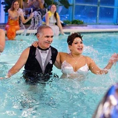
Wishing my #soulmate💙 #merwranglerpirate☠ #happyanniversary 🧜♀️🧔☠️💍 #merwedding #mercouple🧜♀️☠ #1.3.15 tomorrow 1.3.23 will make #9blissful💍 years 🙏🏻💫 #myeverything #ncmerfest2015 #embassysuites #magical #dreamwedding🧜♀️🧔 (at Embassy Suites Cary) https://www.instagram.com/p/Cm71NJcuIwh/?igshid=NGJjMDIxMWI=
#soulmate💙#merwranglerpirate☠#happyanniversary#merwedding#mercouple🧜♀️☠#1#9blissful💍#myeverything#ncmerfest2015#embassysuites#magical#dreamwedding🧜♀️🧔
2 notes
·
View notes
Text

For years I had this photograph in my room, framed and prominently displayed.
My cousins.
It's taken by one of my uncles or aunts a super long time ago on the boat that either just left Gorinchem in Holland for Loevestein Castle... or was on its way back to Gorinchem from Loevestein Castle.
Loevestein Castle?
Yup. An actual medieval castle (with a moat!) a coupla miles upstream on the Merwede River.
Back to my cousins, though.
I'm pretty sure we all have this photograph. It's actually the only one I had for many years until I started taking my own photographs and keeping my own photo albums. Before that, the only way to remember the earliest times we spent together was through my dad's slide shows in our living room at home because my dad had all his vacation photographs developed as slides. So it was a singular occasion to remember our time spent with family in Holland.
The framed picture of my cousins and I on the boat as children, then, was the constant presence of family in Holland for as long as I lived with my parents.
It wasn't until just now, by the way, that I realized I lost that picture. Probably when I moved from my parent's house. Not sure... maybe it's in storage. 😕
So during our just taken trip to Holland, I actually reconnected with that photograph through my uncle, my mom's older sister's husband, who presented it to me on the late afternoon of our third day in Holland at our hotel's lounge. I didn't realize in that moment that I'd long since lost my own copy but—
I enjoyed and appreciated it never-the-less. Even more so now. 😁
The timing of that gift was exquisitely important, as it turns out. Because a few hours later we assembled with as much of my family at the cousins level as could be assembled. A group of us that has not been intentionally assembled in more than two decades.
All of us at once?
It's not clear to me how long since that happened. Our family trips to Holland usually involved visiting my mom's sibling's families one at a time.
So it was easy, growing up, to focus on that long ago photograph of myself and my three cousins as children. Of course, had we assembled all the cousins in one place at that time...
There'd be two more. The two sons of my mother's younger brother and his wife.
Had we assembled everyone a few years later, one of my cousins in the photograph (the one without his sister in the photograph)... would now have a sister.
Had we assembled everyone a decade or so after that... I would now have whatever the cousin equivalent is of brothers-in-law and sisters-in-law.
Had we assembled everyone another ten years later, fifteen years later, I would have a gaggle of second cousins who I call nephews and nieces.
So when we assembled everyone just now, like a minute ago, it's breathtaking to me how much of my family isn't in that childhood photograph with just the four of us. Right now, my family's four generations deep. It's cousins, husbands, wives, aunts, uncles, brothers, sisters, nephews, nieces, sons, daughters, in-laws, parents, children, grandchildren, great-grandchildren, and so on.
Basically it's one heckuva big family I've got over on the other side of the Atlantic.
And, as I said a minute ago, I was just reminded of that. As well as introduced to a bunch family I didn't know...
But now I do.
☺️
#childhood photograph#cousins#gorinchem#holland#merwede river#loevestein castle#boat#husbands#wives#aunts#uncles#brothers#sisters#in-laws#nephews#nieces#sons#daughters#parents#children#grandchildren#great-grandchildren#one big family
0 notes
Text
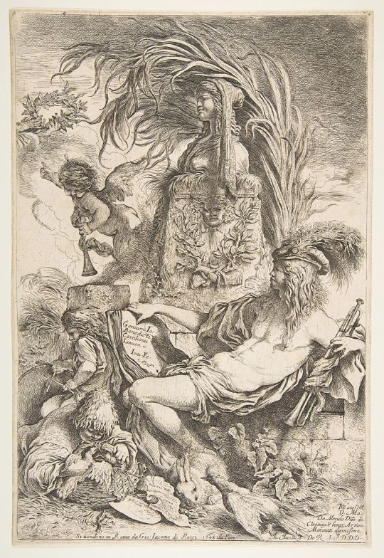
The Genius of Castiglione
Giovanni Benedetto Castiglione (Il Grechetto) Italian
Publisher Giovanni Giacomo De Rossi Italian
Dedicatee Matthys van de Merwede, Lord of Clootwyck Dutch
ca. 1645–47 (published 1648)
Not on view at the met
44 notes
·
View notes
Note
Hello! At what point in the story Moon fell for y/n? I believe first interactions very more guided by curiosity with a little sprinkle of the crush? Like at what moment was he like hmmm I like em and at what point he was like my new mate, the love of my life, Teach me the rrrr with your hor mouth lolol I'm very curious
agahdvbshdjs the rrrrr😋 i'm so glad i kept that in
so i'm keeping some things open and not explicitly stated in the story so ppl can come to their own conclusions, e.g. Moon isn't going to tell Y/N the exact moment he began picking the table toppers for their hypothetical merwedding
but
my personal preference is that around the time he was trying to lure them in he thought they were kinda cute, and while Y/N was trying to 'teach' him English he developed a deeper crush and began to regard them with a great deal of affection. where we are right now... he likes them A LOT and is kind of feeling out the waters. he's not madly in love, like he wouldn't throw his entire life away for them, but it even surprises him just how much he likes them. he's beyond the point of just a crush rn
30 notes
·
View notes
Text
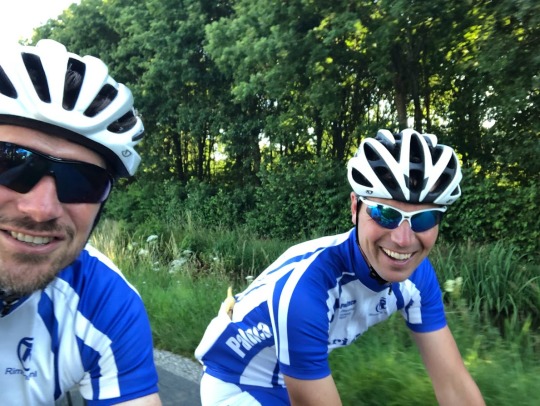
Palinca toer door de achtertuin van Martijn
Het was wel even geleden dat we elkaar in levende lijve gezien hadden. En nog veel langer geleden dat we samen gefietst hadden. Maar vandaag was het zover, Team Palinca ging weer eens fietsen. Of, om niet alle sponsors teleur te stellen, Team Palinca Christina Rimonta. De afspraak was dat we naar Martijn zouden gaan, die ons dan een rondje voorschotelen door zijn achtertuin.
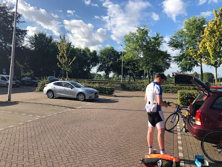
Om half acht hadden Eelco, René en ik afgesproken in Zoetermeer en gezamenlijk reden we met de auto naar Schoonhoven alwaar we de auto's parkeerde en met de pont overvoeren naar Gelkenes waar we hadden afgesproken met Martijn. Hoewel we elkaar te lang niet gezien hadden was alles weer vanouds. Het omkleden op eel louche parkeerplaats. De onzin die we onderling communiceerde. Kortom, alles was weer zoals het was. René en Martijn reden nog gewoon met een ouderwetse fietscomputer. Eelco had nog gewoon een twee-en-veertig binnenblad. Martijn die de route had uitgezet mocht op kop rijden. Omdat ik het meest fitte van het stel was mocht ik naast hem plaats nemen.
Omdat we elkaar lang niet gezien hadden was er genoeg bij te kletsen. Kinderen die laatst nog met luiers om liepen hadden nu een rijbewijs. Ondertussen waren we de nodige keren van baan veranderd, maar een hoop dingen waren het zelfde gebleven gelukkig.
De route die Martijn had uitgezet ging via de buitenwijken van Groot-Ammers via Ottoland en Schelluinen naar Gorkum waar de de Boven-Merwede overstaken. Volgens Martijn zaten we nu op een ander eiland. Dat klopt ook wel wan we hadden de Alblasserwaard ingeruild voor het Land van Heusden en Altena. We volgde vanaf hier de dijk langs de Boven-Merwede richting het pittoreske stadje Woudrichem
Na een stuk langs de Afgedamde Maas staken we deze over voor een lusje richting Slot Loevestein. We hadden Noord-Brabant ingeruild voor Gelderland en het Land van Heusden en Altena voor de Bommelerwaard. Na Slot Loevestein volgde we de dijk langs de Waal. Daarbij reden we ook door Brakel, waar geen spoor was te vinden van "De Zwarte " en ook Ten Bosse hadden we niet gevonden. Daarom bleven we de dijk maar volgen tot Zaltbommel. Daar kregen we een paar kasseistroken voorgeschoteld, welke Martij omzeilde door het naastgelegen klinkerstrookje te pakken, maar dit is totaal Palinca onwaardig. In het centrum van Zalrbommel plofte we neer voor een bak koffie met gebak. Daar werd ongestoord verder gekletst.
Dat we voor een goede locatie hadden gekozen voor de koffie bleek wel wat later toen diverse andere pelotons neerstreken op het terras. Maar zo toevallig was het nou ook weer niet. Want op dit zelfde terras zaten we ook toen we onze befaamde Driedaagse Schin op Geul reden. We wisten dus dat het goed was. Na de koffie staken we de Waal over naar de Tielerwaard
Via diverse landwegen werd er koers (of is het nou coers) gezet naar de Linge. We volgde nu een aantal wegen welke ik een paar weken geleden in tegengestelde richting reed. Na Acquoy kregen we een stuk gravelstrook te verwerken. Hoewel, voor ons Palinca's is dat gewoon een grindstrook waar je niet te lang over moet doen.
Bij Leerdam lieten we de Linge voor wat het was en volgde nu de Diefdijk. Deze keer niet op de dijk maar een weg parallel onder aan de dijk wat een prima route is. Halverwege gingen we wel de dijk op en volgde deze tot aan het fort Goilberdingen. Hier gingen we linksaf in westelijke richting. En dat was lachen want de wind was aardig aangewakkerd en we hadden hem natuurlijk tegen. Tot Vianen reed ik met Martijn op kop maar na Vianen nam René de kop over. Net als van ouds ging het tempo ook omhoog waarbij René zijn beruchte houding aannam plat op het stuur. De rest weet dan al hoe laat het was, dat werd weer pijn lijden. Ik wist het wel lang vol te houden maar ging na verloop van tijd even uit de wind rijden. Eenmaal bijgekomen nam ik mijn positie op kop weer in samen met René. Het was nog een kleine tien kilometer tot Martijns huis. Ondertussen waren een aantal mannen die in ons wiel zaten op kop gekomen, reden voor ons uit, lieten zich weer afzakken. Ik kreeg er geen hoogte van. Ze deden wat er op hun shirt stond, ze reden Chase Papat.
Terwijl Martijn eraf fladderde reden René en ik zijn huis voorbij. Dat was niet helemaal de bedoeling, we keerde om en uiteindelijk was Martijn de eerste die thuis was. Na een bak koffie maakte we de nodige afspraken, iets met een barbecue en een ritje naar Hillywood om het nieuwe huis van Ien te bezoeken.
Daarna namen we afscheid van Martijn en gingen rustig op huis aan, het was weer een mooie dag.
2 notes
·
View notes
Text
De Rotterdamse Schie, 1939.
De Rotterdamse Schie was de vaart die ten gevolge van een handvest van 9 juni 1340 werd gegraven van Overschie naar Rotterdam. Ze sloot aan op de reeds bestaande Delftse of Oude Schie, die Delft met Overschie verbond. Ter plaatse van het latere Hofplein kwam de Schie uit in de Kolk welke door de Rotte was gevormd. Vanaf dit punt ging de vaart door de stad onder de naam Delftsevaart. Deze was via een spuisluis verbonden met de Merwede (Nieuwe Maas). De Schie komt ook een enkele maal voor als Spuivaart.
Langs beide zijden van de vaart werden kaden aangelegd. In het begin waren deze van weinig betekenis. De Oost-Schiekade was omstreeks 1562 nog maar een betrekkelijk smalle zomerkade. Eerst in 1741 werd deze door de stad bestraat, voor rekening van de eigenaars van de huizen aan de kade en de 1ste, 2de en 3de Schielaan. Dit waren drie laantjes die vanaf de Oost-Schiekade langs de tuinen van de buitenhuizen liepen. De West-Schiekade was breder en werd als rijweg naar Delft gebruikt. Bij een overeenkomst in 1471 werd bepaald dat het onderhoud van deze weg van de Delftse Poort tot aan het Leprooshuis voor rekening van de stad kwam. Het onderhoud van het gedeelte tot aan de Waelheul (Heulbrug) zou worden betaald door de ingelanden van de ambachten van Beukelsdijk, Cool, Schoonderloo, West-Blommersdijk en Blijdorp.
In verband met de bouw van de wijken Blijdorp en Bergpolder werd in 1931 besloten het gedeelte van de Schie tussen de melkmarkt (latere Stadhoudersplein) en de spoorbaan te dempen. De gemeenteraad besloot op 22 juni 1939 tot demping van het gedeelte van de Schie, gelegen tussen het Hofplein en het Stadhoudersplein. Deze demping geschiedde voor een groot gedeelte met het puin van de huizen, die verwoest waren bij het bombardement. Sindsdien is een bekend Rotterdams gezegde 'Eerst lag de Schie in Rotterdam, thans ligt Rotterdam in de Schie'
De fotograaf is Henri Berssenbrugge en de foto komt uit het Stadsarchief Rotterdam. De informatie komt eveneens uit het Stadsarchief Rotterdam.
1 note
·
View note
Text
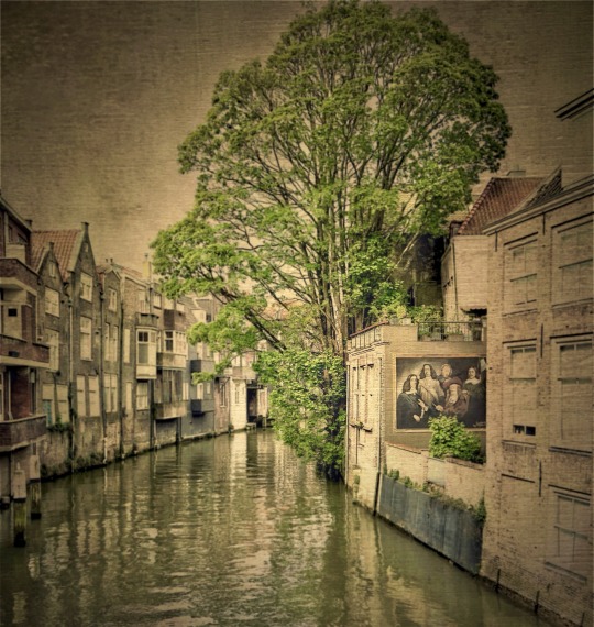
Medieval Dordrecht
Dordrecht
Dordrecht, the Netherlands Oldest City
The medieval city of Dordrecht dates back to the 11th century. Situated at the confluence of several rivers, including the Meuse, Merwede, and Rhine, it became a strategic trading hub in the medieval period. The city flourished as a center for trade, particularly during the Dutch Golden Age in the 17th century.
The picturesque city’s…
View On WordPress
#Culture#Dordrecht#Europe#Fine Art Photography#holland#Impressionism#Landscape#Medieval#Netherlands#Photography#Ron Mayhew#Travel Photography#Travel Theme
0 notes
Text
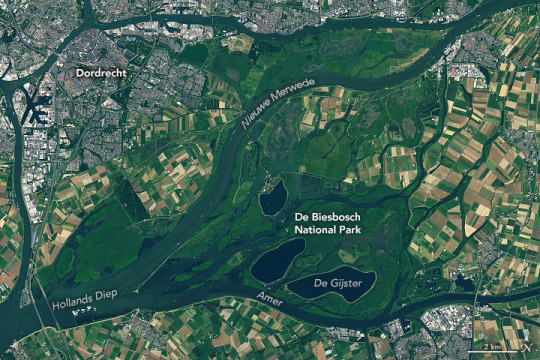
The Biesbosch of the Netherlands
Within the Netherlands’ De Biesbosch National Park, abundant wildlife—from beavers and otters to kingfishers and egrets—thrive among reed beds and willow stands. But the verdant appearance of this large freshwater tidal wetland belies what is really a highly engineered landscape. The defining event shaping it today was a devastating flood in the 15th century. Since then, it has continued to evolve under the forces of rivers, tides, and human efforts to manage the water.
This image shows the national park, which was established in 1994, within the lower Rhine and Meuse delta. Agricultural land and the industrial port city of Dordrecht, which flank the wetlands, are also visible. The image was acquired by the OLI (Operational Land Imager) on Landsat 8, on July 8, 2023.
In November 1421, an extratropical cyclone struck the region, setting off what is known historically as St. Elizabeth’s flood. Swollen rivers and tidal surges led to dike failures. The floodwaters destroyed numerous villages and likely claimed thousands of victims in the area that is now the Biesbosch.
That flood created a large inland sea, where, over time, rivers and tides deposited sediments, and the landscape gradually morphed into one of islands and winding waterways. Reeds and grass-like aquatic plants called rushes established themselves on the sandy banks (Biesbosch roughly translates to “forest of rushes”), and some of the land was reclaimed for agriculture.
In recent centuries, a series of major engineering projects helped transform the Biesbosch into a largely human-dominated landscape. Prominent in the image are the Nieuwe Merwede canal, built in the mid-19th century for flood control, and three reservoirs including De Gijster, constructed in the 1970s to store water for domestic and industrial uses.
But instances of flooding persisted into the 20th century, including a deadly and damaging flood in 1953. Following that event, the Dutch Ministry of Infrastructure and Water Management embarked upon a massive flood control project called the Delta Works. The initiative included building new sluices to close off the Haringvliet estuary, a North Sea inlet downstream of the Biesbosch. When this happened in 1970, tidal ranges in the Biesbosch dropped from approximately 1.9 meters (6 feet) to around 0.4 meters (1.3 feet).
Today, visitors to the national park explore the flora and fauna of the protected natural area via hiking trails and waterways. The ecosystem they experience evolves, as well. For example, a rewilding organization is investigating whether the waterways can again support European sea sturgeon (Acipenser sturio). This anadromous fish was once abundant in the Rhine delta but has not been seen in Dutch waters in decades due to overfishing, degraded water quality, and obstructed channels. Dozens of young sturgeon were recently released into the Biesbosch to determine if a larger reintroduction might be successful.
NASA Earth Observatory image by Lauren Dauphin, using Landsat data from the U.S. Geological Survey. Story by Lindsey Doermann.
0 notes
Text
Gemeente Altena heeft een kwartiermaker aangetrokken voor het project derde haven in Werkendam. De behoefte aan ruimte voor het Werkendamse Maritieme cluster is groot en urgent. De bedrijven spelen een grote rol in het verduurzamen van de scheepvaart. Het Werkendamse maritieme cluster is dan ook meer dan ooit nodig voor de ontwikkeling en realisatie van innovatieve oplossingen voor een toekomstbestendige scheepvaart. En dat vergt ruimte in en aan de haven. Het beschikbaar maken van ruimte is een uitdaging, maar wel één die de gemeente graag aangaat.
Vervolg na MIRT-onderzoek
Eind vorig jaar is het MIRT-onderzoek afgerond naar havenontwikkeling Werkendam en integraal riviermanagement (IRM). Het onderzoek is een eerste stap geweest om met andere partijen zoals het ministerie van Infrastructuur en Waterstaat, Rijkswaterstaat, provincies Noord-Brabant, Zuid Holland en Gelderland, Waterschap Rivierenland en Werkendam Maritime Industries de haalbaarheid van een derde haven te onderzoeken. Niet als losstaand project maar in samenhang met andere ambities en opgaven die langs de uiterwaarden van de Merwede aan de orde zijn.
Onderzoek laat kans zien tussen opgaven en gewenste uitbreiding
Het onderzoek geeft niet alleen een beeld hoe die ambities, opgaven en initiatieven van verschillende partijen samenhangen, maar ook dat er een unieke kans is om de verschillende opgaven met de gewenste uitbreiding van de haven van Werkendam te combineren. Bijvoorbeeld een dijkversterking ter plaatse van de derde haven. Daarvoor is nog wel het nodige te doen. Om daar stappen in de zetten heeft de gemeente een kwartiermaker aangetrokken in de persoon van Lijdia Pater-de Groot van Movares-Water.
Kwartiermaker Lijdia Pater-de Groot heeft een belangrijke rol in het verbinden en aanhaken van belangrijke partijen zoals bedrijven, het Rijk, brancheorganisaties, provincies en de regio. Daarnaast gaat zij aan de slag om de haalbaarheid van de haven verder te onderzoeken onder andere op het gebied van financiën en benodigde vergunningen.
Derde haven ontwikkelen is niet makkelijk, wel nodig
Wethouder Hans Tanis: “Het ontwikkelen van een derde haven is geen gemakkelijke opgave. Maar we hechten er groot belang aan dat het Werkendamse maritieme cluster voldoende ruimte krijgt om de vooraanstaande positie, met name ook op het gebied van innovatie en vergroening van de scheepvaart, te kunnen blijven waarmaken. Schepen worden de komende jaren op grotere schaal gereviseerd of omgebouwd om aan duurzaamheidseisen te voldoen. Continuïteit van een vooraanstaand en innovatief scheepvaartcluster in Werkendam vergt ruimte. En die willen we maken. Met een kwartiermaker als voorloper, denken we hierin stappen vooruit te kunnen zetten”.
Kwartiermaker Lijdia Pater
Kwartiermaker Lijdia Pater heeft grote ervaring in de wereld van de scheepvaart, is zelf scheepvaartondernemer geweest en heeft allerlei posities bekleed binnen de scheepvaartbranche. Lijdia Pater: “De maritieme maakindustrie - onmiskenbaar het hart van het Werkendamse scheepvaartcluster - is meer dan ooit nodig voor de ontwikkeling en realisatie van innovatieve oplossingen voor een toekomstbestendige scheepvaart.
Het Werkendamse maritieme cluster kan bijdragen aan de transitie naar een klimaatneutrale en emissieloze scheepvaart én daarmee aan een bereikbaar, duurzaam en leefbaar Nederland en Europa. Namens de gemeente Altena ga ik mij inzetten om samen met andere partijen de plannen verder te ontwikkelen en stappen te zetten richting mogelijke uitbreiding.”
0 notes
Text
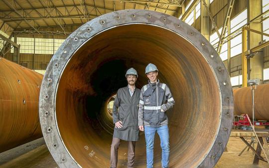
Hier worden de buizen van de hyperloop gemaakt. Bouw testbaan Veendam start in maart
Politici in Groningen vinden de stilte rond de hyperloopplannen bij Meerstad verontrustend: komt die testbaan nog? In Gorinchem is het allesbehalve stil. Aan de oever van de Boven-Merwede vonken lasapparaten en krijsen schuurmachines. De eerste 35 buizen van de hyperloop zijn er volop in constructie.
#Hier #worden #buizen #van #hyperloop #gemaakt #Bouw #testbaan #Veendam #start #maart
View On WordPress
0 notes
Photo

My #love my #everything #soulmates❤️ #truelove #merwedding #mercouple🧜♀️☠ #blessed 1.3.15-1.3.23 #happyanniversary to us 💕 #happilyeverafter does exist #dreamscometrue never settle it's worth the wait for your #truelove #soulmate (at Embassy Suites Cary) https://www.instagram.com/p/Cm71y33OU6x/?igshid=NGJjMDIxMWI=
#love#everything#soulmates❤️#truelove#merwedding#mercouple🧜♀️☠#blessed#happyanniversary#happilyeverafter#dreamscometrue#soulmate
1 note
·
View note
Text
Yesterday we got a late start. Our niece and her dad were in Amsterdam for the Friends Experience because they are both HUUUUUUUGE fans of the show.
They had tickets for a while now but my niece somehow forgot and went already with a friend of hers. Then yesterday she went again with her dad because, you know, Friends.
The experience involves accurate and various Friends sets and moments... and the two of them took full advantage with photographs of themselves in iconic spaces recreating iconic moments.
They both said it was super busy because the day got off to a delayed start due to technical problems... so there were more people than expected crammed into a shorter schedule. Still, the pictures they took make it seem like they're the only ones on set.
Adorable. 😊

Around 2 in the afternoon I get a text they're on their way back from Amsterdam... so at 230 we leave our hotel for the local grocery store, Aldi, because Kimmer literally cannot get enough of the place.
Also, I'm not clear why we need more food. My aunt is a relentless feeder of family members. Plus we've got a stock of baked foods we keep receiving as gifts from family over the last few days.
Still, we're going up and down the aisles looking... looking...
And yeah. We find a gift or two for someone or someone's at home.
Don't tell them, though.
It's a surprise. 😉
3pm and my niece and her dad are pulling up to our hotel. Since we're still at Aldi, they drive down the street to pick us up...
And then we're on our way to the center of Gorinchem.
Now first we've gotta a coupla highly important things to figure out.
Here's how my niece put it:
"So my father and I are discussing a few options. We thought we could get a chai latte 😆 we could go into town and drink some in one of the local lunchrooms. Then I can take the card game to my grandparents tonight! Or we could get the chai latte to go and go to our house. Or we don’t get a Chai latte 🤣🤣 so many options😆"
Yeah.
Complicated. 😉
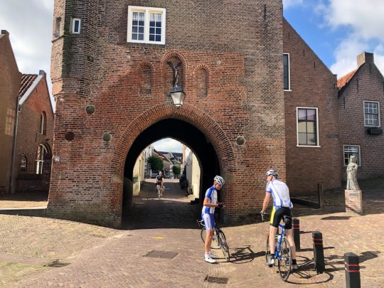
We quickly decide the Chai Latte is essential to our afternoon so we head to Gorinchem Centrum and park in the Kweeklust parking garage along one of the rivers surrounding the centrum.
We spend the next hour walking from the north end to the south end where there are locks and then those boats that take tourists down the Merwede river to castle Slot Loevestein.
I'm pretty sure this is the dock from which my cousins 'n I as children made that trip ourselves with our parents, one of whom took an iconic photograph of us.
From the parking garage, Kimmer 'n I do a pretty good job of walking and being present with family. This part of town is so picturesque, though, there's so much unique architecture, so much fascinating detail, that for a while in there we become raging photography monsters, eating up everything we see along the way.
youtube
This is, of course, my niece and her dad's hometown. It's also a small town and every so often they run into someone they know.
And then another someone.
And another someone.
Yeah.
That small.
Either that or they're both quite famous and we just don't know it. 🤔🤨
Along the way, both my niece and her dad point out the shops and cafes they frequent: a record store here, a high-tea restaurant there. It's a lovely bit of family Show 'n Tell. 😊
For example, my niece points out an entrance to a church that used to be walled off, hidden from the Nazi's during the occupation of Holland during World War II.
My niece's dad one-upped her by pointing out a lane along which is a row of connected, narrow homes. In one of these, he tells us, is the home in which he was born.
He just can't remember exactly which one. 😕
He can tell us, though, that the building across the narrow lane from the row houses used to be an orphanage. And then a block later we run across a shop featuring a painting of Hugo the Great and an illustration of castle Slot Loevestein which prompted a telling of this slice of dutch history in which Hugo is captured, taken to the town center where villagers help him escape inside a wooden cabinet.
Huzzah!
By 'n by, we wander to a historic door that's related to the Hugo the Great story... next to which is Espressobar Hugo.
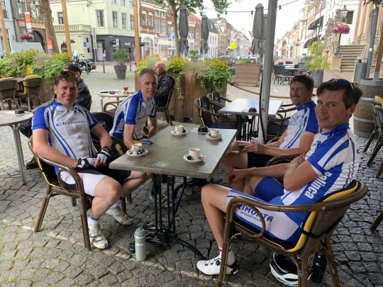
Where we get our Chai Lattes.
It's 4pm.

A lovely little espresso place, the bar offers a full sit-down experience: take your seat, check out the menu, and soon someone comes by to take your order.
Eventually, our Chai lattes are brought to the table. Actually, three Chai lattes and one cappuccino 'cause that's my niece's dad's jam.
The Chai, by the way, comes in tall, thick, clear glass cups accompanied by a shot of whipped cream with Bailey's and a little square of chocolate brownie.
Kimmer couldn't have hers... so she gave it to me for a sum total of two little brownie squares for my afternoon.
After a lovely hour of hot drinks, good fun company, and a bunch of photos Kimmer felt compelled to take at the back of the espresso bar, we take our leave of Gorinchem in order to swing by the home of my niece's family.
Why?
Because our day's primary agenda with her is to play her Harry Potter trivia game.
We've taken most of the afternoon with a lovely city walk, so now we're gonna grab the game on our way to my aunt and uncle's to play after dinner there.
Of course it's not a grab 'n go we do. The "stop" easily turns into a Show 'n Tell of their home including the "shed" out back that's a pretty massive deal with plenty of storage inside and a covered space outside for lounging on chairs. There's even a sign over the window facing the covered space that reads
Surf Shack. 🙂
It's actually more fun than I'd guess getting a tour of someone else's home. But this one's comfortable and hits a lot of the same design notes that we love from lighting to furniture to decor (including the old-school LPs and the Lego VW bus).
6pm We're back at my aunt and uncle's place for dinner. At the dinner table's their daughter (arriving a little later than the rest of us due to work), her husband, their daughter/my niece, and then us.
Once again it's a lovely time had by all with a thoroughly traditional Dutch menu including variations on mashed potatoes, sausages, and beef.
After dinner, we settle around the table to play my niece's Harry Potter trivia game. We don't specifically read or follow the rules... we just play in a way that makes sense to us and is fun for us.
So.
Is it fun?
Well, all I can say is it's LOUD. It's competitive. And we're super into it against each other and with each other.
Because that's how we roll. 😉
Now, while we're thoroughly into all things Potter, my cousin's husband's in the living room with my aunt and uncle revisiting some of my uncle's history.
Meanwhile (and I don't know how this happened) the game we're playing at the dining room table turns into a wide-ranging conversation about the British royal family, from "The Crown" to the tabloids to each royal to each royal couple.
Again. No idea how that happened.
Definitely the conversation drew my aunt into the room. My aunt... who isn't into Harry Potter trivia games but is quite able to weigh in on British royals past and present. 🤔🤨
And then somehow (again, I don't know how) the conversation pivots to the challenges of being a parent and the simultaneous, complementary challenges of growing up. It's another wide-ranging and detailed conversation with everyone everyone everyone at the table weighing in.
'Cause we're all experts like that.
With so many parents at the table, it's like a support group. 😉
Inevitably, our arrival at 6pm flips through more hours than I would've guessed because suddenly it's 11 o'clock at night.
Did not see that coming either.
So, with hugs and kisses all around, my cousin's husband and niece drop us back at our hotel at 11:30.
Dang.
Talk about Time Travel.
That time at my aunt and uncle's flew.
And yeah. It's amazing how much life you can cram into those hours...
When you're with your tribe.
☺️

#the friends experience#friends#aldi grocery store#chai latte#walking#strolling#picturesque town#espressobar hugo#harry potter#harry potter trivia game#surf shack#dinner#family#dutch food#games#competition#fun#laughter
2 notes
·
View notes
Text
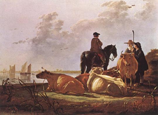
CUYP, Aelbert
Peasants with Four Cows by the River Merwede
-
Oil on wood, 38 x 50 cm
National Gallery, London
24 notes
·
View notes
Link
0 notes
Text
Jmap altitude geometry

In 1801, the chief of the French Corps of Engineers, Haxo, used contour lines at the larger scale of 1:500 on a plan of his projects for Rocca d'Anfo, now in northern Italy, under Napoleon. Dupain-Triel used contour lines at 20-metre intervals, hachures, spot-heights and a vertical section. Such lines were used to describe a land surface (contour lines) in a map of the Duchy of Modena and Reggio by Domenico Vandelli in 1746, and they were studied theoretically by Ducarla in 1771, and Charles Hutton used them in the Schiehallion experiment. The Dutch engineer Nicholas Cruquius drew the bed of the river Merwede with lines of equal depth (isobaths) at intervals of 1 fathom in 1727, and Philippe Buache used them at 10-fathom intervals on a chart of the English Channel that was prepared in 1737 and published in 1752. In 1701, Edmond Halley used such lines (isogons) on a chart of magnetic variation. The oldest known isobath (contour line of constant depth) is found on a map dated 1584 of the river Spaarne, near Haarlem, by Dutchman Pieter Bruinsz. The idea of lines that join points of equal value was rediscovered several times. Įdmond Halley's New and Correct Chart Shewing the Variations of the Compass (1701) In the latter case, the method of interpolation affects the reliability of individual isolines and their portrayal of slope, pits and peaks. Contour lines may be either traced on a visible three-dimensional model of the surface, as when a photogrammetrist viewing a stereo-model plots elevation contours, or interpolated from the estimated surface elevations, as when a computer program threads contours through a network of observation points of area centroids. The configuration of these contours allows map readers to infer the relative gradient of a parameter and estimate that parameter at specific places. A level set is a generalization of a contour line for functions of any number of variables.Ĭontour lines are curved, straight or a mixture of both lines on a map describing the intersection of a real or hypothetical surface with one or more horizontal planes. When the lines are close together the magnitude of the gradient is large: the variation is steep. The gradient of the function is always perpendicular to the contour lines. The contour interval of a contour map is the difference in elevation between successive contour lines. A contour map is a map illustrated with contour lines, for example a topographic map, which thus shows valleys and hills, and the steepness or gentleness of slopes. In cartography, a contour line (often just called a "contour") joins points of equal elevation (height) above a given level, such as mean sea level. More generally, a contour line for a function of two variables is a curve connecting points where the function has the same particular value. It is a plane section of the three-dimensional graph of the function f ( x, y ) -plane. A two-dimensional contour graph of the three-dimensional surface in the above picture.Ī contour line (also isoline, isopleth, or isarithm) of a function of two variables is a curve along which the function has a constant value, so that the curve joins points of equal value.
0 notes
Text
De Teilingerstraat uit het noorden, 14 augustus 1989. Op de achtergrond de Schiekade.
De Teilingerstraat heet naar Simon van Teilingen. Eigenlijk heette hij Simon van Benthem. Hij en zijn vrouw Agniese Bokel ontvingen in 1339 van graaf Willem IV het huis te Teilingen en enige daarbij behorende goederen in leen. Sindsdien noemde Van Benthem zich bij voorkeur Simon van Teilingen. Vermoedelijk sneuvelde hij in juni 1345 tijdens de slag bij Warns (Friesland).
De naam van de Schiekade is ontleend aan de Rotterdamse Schie, de vaart ten gevolge van een handvest van 9 juni 1340 gegraven van Overschie naar Rotterdam. Ze sloot aan op de reeds bestaande Delftse of Oude Schie, die Delft met Overschie verbond. Ter plaatse van het latere Hofplein kwam de Schie uit in de Kolk welke door de Rotte was gevormd. Vanaf dit punt ging de vaart door de stad onder de naam Delftsevaart. Deze was via een spuisluis verbonden met de Merwede (Nieuwe Maas). De Schie komt ook een enkele maal voor als Spuivaart.
Langs beide zijden van de vaart werden kaden aangelegd. In het begin waren deze van weinig betekenis. De Oost-Schiekade was omstreeks 1562 nog maar een betrekkelijk smalle zomerkade. Eerst in 1741 werd deze door de stad bestraat, voor rekening van de eigenaars van de huizen aan de kade en de 1ste, 2de en 3de Schielaan. Dit waren drie laantjes die vanaf de Oost-Schiekade langs de tuinen van de buitenhuizen liepen. De West-Schiekade was breder en werd als rijweg naar Delft gebruikt.
De fotograaf is Lex de Herder en de foto komt uit het Stadsarchief Rotterdam. De informatie komt eveneens uit het Stadsarchief Rotterdam.
0 notes
Last Seen Blogs
fukahiretoufu
@fukahiretoufu

arsonistman
Reality? No Thanks

mariannaraskinphotos
Marianna's Photos
a-list-of-dumbass-quotes
A List Of Dumbass Quotes