#geospatial
Text
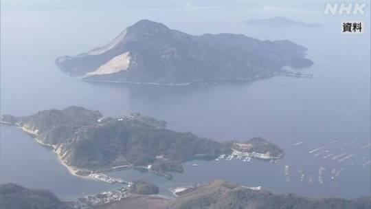

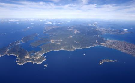
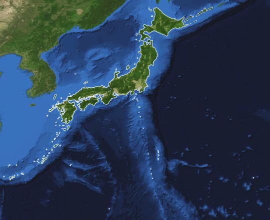
Sean bienvenidos japonistaarqueológicos, a una nueva actualidad del país del sol naciente. En este caso os comentaré que se han actualizado los datos del número de islas del archipiélago Japonés, dicho esto pónganse cómodos que empezamos.
-
La información viene de la agencia Geoespacial de Japón, el número de islas son de 14125 en todo el país, más del doble del número anunciado hasta ahora, en 1987 el cálculo era de 6852 islas.
-
El número de islas en cada prefectura
Nagasaki 1479
Hokkaido 1473
Kagoshima 1256
Iwate 861
Okinawa 691.
-
¿Qué opinan al respecto? Espero que tengan una buena semana y nos vemos en próximas publicaciones de Japón
-
日出づる国から新しいニュースへようこそ。今回は、日本列島の島の数が更新されたことをお伝えします。
-
国土地理院からの情報ですが、日本全国の島の数は14125で、今まで発表されていた数(1987年は6852島)の2倍以上になっています。
-
各都道府県の島嶼数
長崎県 1479
北海道 1473
鹿児島県 1256
岩手県 861
沖縄県 691
-
いかがでしょうか?今週も良い一週間をお過ごしください。また、今後の日本からの投稿でお会いしましょう。
-
Welcome to a new update from the land of the rising sun. In this case I will tell you that we have updated the data on the number of islands in the Japanese archipelago, so make yourselves comfortable and let's get started.
-
The information comes from the Geospatial agency of Japan, the number of islands is 14125 in the whole country, more than double the number announced until now, in 1987 the estimate was 6852 islands.
-
The number of islands in each prefecture
Nagasaki 1479
Hokkaido 1473
Kagoshima 1256
Iwate 861
Okinawa 691.
-
What do you think about it? I hope you have a good week and see you in future posts from Japan.
#日本#島#地理#長崎#北海道#鹿児島#岩手#沖縄#地理空間#庁舎#-#japan#islands#geography#Japanese#Nagasaki#Hokkaido#Kagoshima#Iwate#Okinawa#geospatial#agency#歴史#history#ユネスコ#unesco
25 notes
·
View notes
Photo
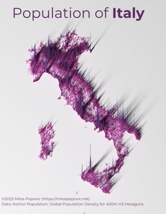
Italy population density.
by @milos_agathon
143 notes
·
View notes
Text
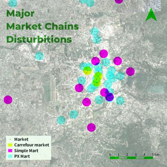
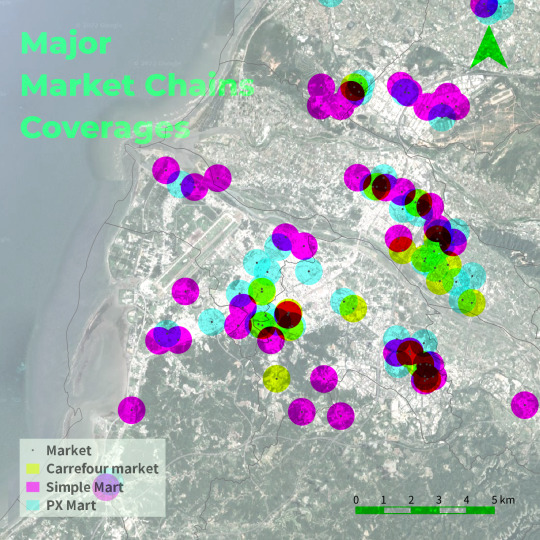
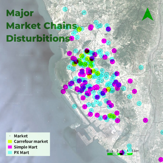
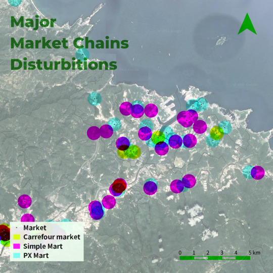
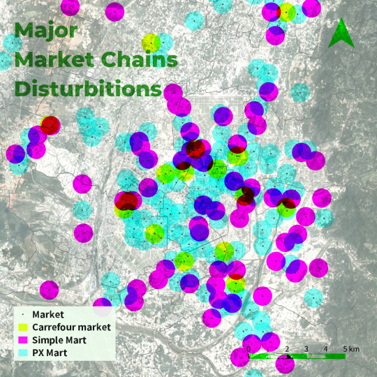
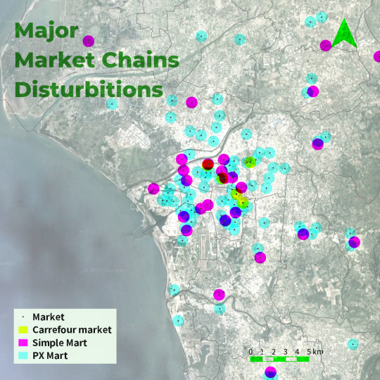
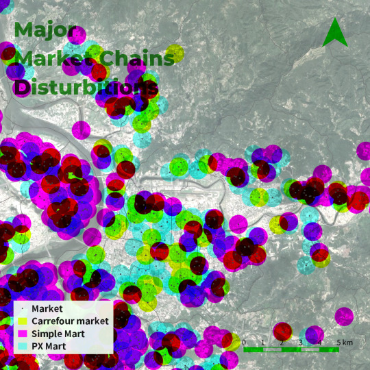
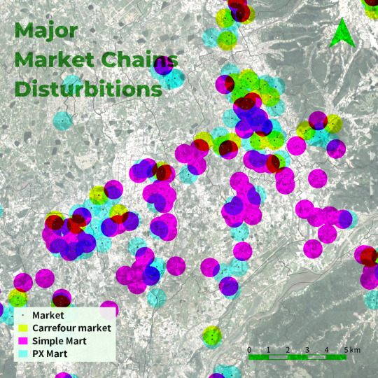
PXmart, Carrefour, and Simple Mart are the major supermarket chains in Taiwan that are commonly seen in cities. However, the strategy of these brands is very different. PXmart has the most locations and can be found in rural areas. Carrefour stores were mostly found in city centers, whereas Simple Mart was mostly on the periphery.
8 notes
·
View notes
Photo
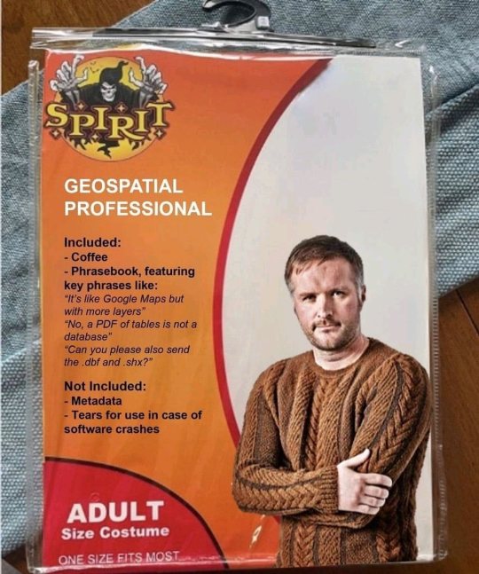
Nailed it! Thanks Austin, I died laughing when I got it. #geospatial #gis #geographicinformationsystems #culturesources #maps #happymappy #cartography #halloweencostume (at Hammock De Galvez) https://www.instagram.com/p/CkTQBIOsXMj/?igshid=NGJjMDIxMWI=
#geospatial#gis#geographicinformationsystems#culturesources#maps#happymappy#cartography#halloweencostume
12 notes
·
View notes
Text
I'm good at shaving my girlfriends vag .I love doing it , shave her pus this weekend and it went very well . So... Any ladies could use a hand with that razor I'm very proficient and will assist at your convenience and nothing is better then spending time a lady it is how I unwind One love
4 notes
·
View notes
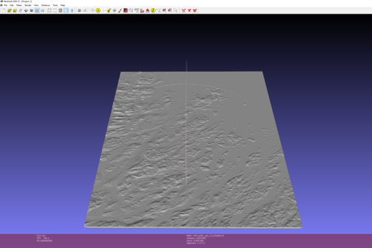
Text
Printing a landscape model
So, the workflow is to download a DEM from Earth Explorer (USGS website), and then import this into QGIS where it will be used to create a 3D model.
Create a profile on earthexplorer.usgs.gov
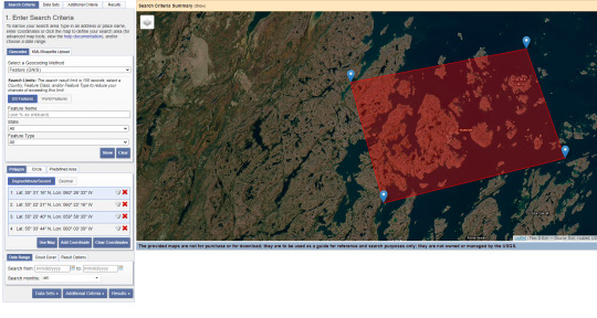
Then select your area using the search criteria
Then select the srtm 1 Arc-second Global dataset
go to results and click the foot button beside your results, and if the areas look good, click the button with the green arrow point down (download), then download the GeoTIFF file, and leave the others.
Download and install QGIS
go to the plugins tab, click manage and install and then in the dialog box, search 3d printing, and install the dem to 3d plugin
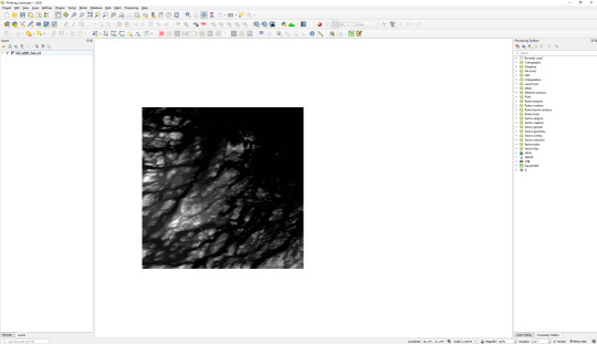
drag and drop tiff or tiffs over qgis when open so it looks like this
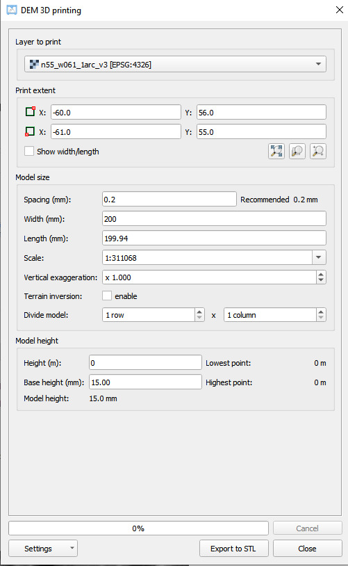
click on raster tab,the DEMto3D in dropdown to open plugin
in layer to print, use drop down to select layer
in print extent select the middle one to print that area, or the right one to drag over an area
in "Print Extent"options, set spacing to min recommended, set width to a given width (this will set length, leave ratio), dw about scale, experiment with vertical exaggeration
set Model Height to 0 and set the base height to w/e you feel like, then click export to stl, should make an stl layer and it should look like below
My model for printing looked like this afterwards
6 notes
·
View notes
Text
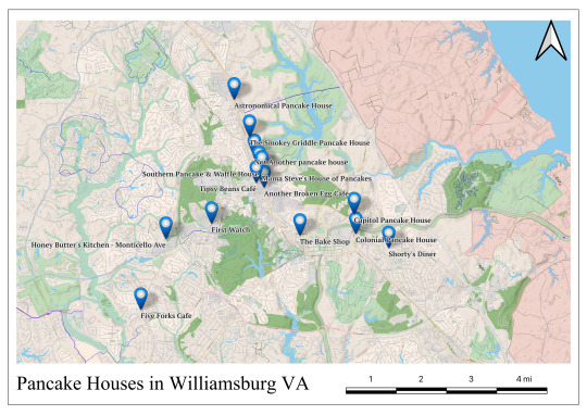
The locations we will be visiting, just a quick and lazy layout I made in QGIS. I'll make a better one later in the week, but since we're visiting our first pancake house tomorrow I wanted to have a map up.
The full list of the fourteen locations is:
Another Broken Egg Café
Astronomical Pancake House
Capitol Pancake House
Colonial Pancake House
First Watch
Five Forks Cafe
Honey Butter's Kitchen
Mama Steve's House of Pancakes
Not Another Pancake House
Shorty's Diner
Southern Pancake & Waffle House
The Bake Shop
The Smokey Griddle Pancake House
Tipsy Beans Café
Wikipedia defines pancake house as "A pancake house, pancake and waffle house or waffle house is a restaurant that specializes in breakfast items such as pancakes, waffles, and omelettes, among other items."
Some stops on this "tour" may not be considered a pancake house by some, but the restaurants selected all fit this definition in some way.
#comfort food#american food#food review#food#review blog#breakfast#pancakes#brunch#colonial williamsburg#william and mary#geospatial#mapping#pancake house
2 notes
·
View notes
Photo
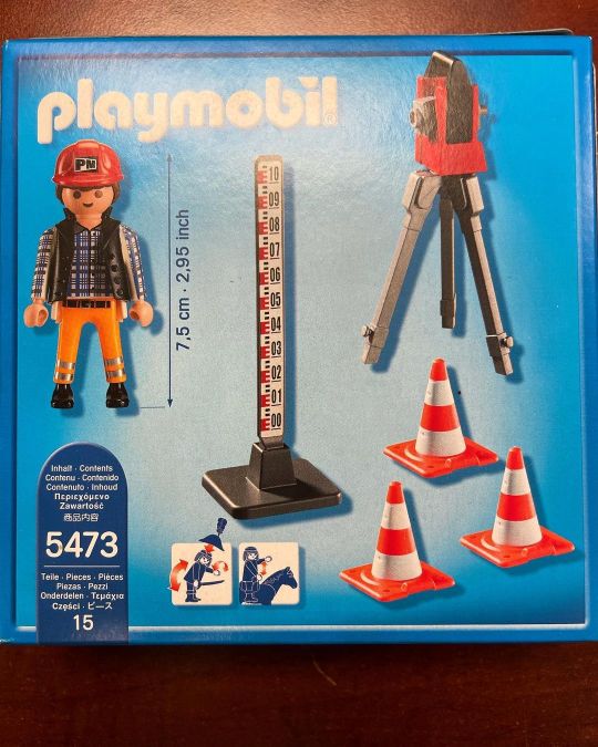
Playmobil surveyor is what I got from my daughter yesterday! So great full she know I love the profession! #survey #takeoff #3dmodeling #surveying #landsurveying #trimble #drafting #surveyinglife #buildingsurveying #lovesurveying #dataprep #earthworks #trimblebusinesscenter #sitemodz #prositeconsulting #surveyworld #geospatial #geodesy #mixedreality #sitemodz #Trimble geospatial #leicageosystems (at Spruce Grove, Alberta) https://www.instagram.com/p/ChH1NSXr-2I/?igshid=NGJjMDIxMWI=
#survey#takeoff#3dmodeling#surveying#landsurveying#trimble#drafting#surveyinglife#buildingsurveying#lovesurveying#dataprep#earthworks#trimblebusinesscenter#sitemodz#prositeconsulting#surveyworld#geospatial#geodesy#mixedreality#leicageosystems
5 notes
·
View notes
Text

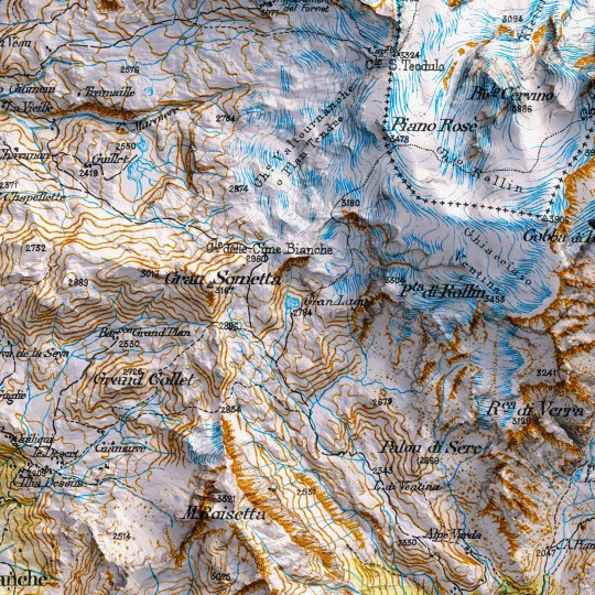
Time for a revamp!
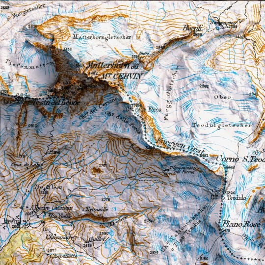
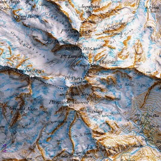
An awesome 1898 map of the Mount Rosa from the collection "Carte du versant italien des Alpes 1899 - 1902".
If you like our work, want to see our daily updates (or want to say hello to our studio), consider to follow our Instagram or Twitter account. Otherwise if are interested in our prints or have a custom request check our shop.
#mattehornglacierparadise#mattehorn#cervinocinemountain#mtrosa#hickingadventures#topographicmap#3dart#3dmap#blender3d#geospatial#geospatialdata#datavizart#dataviz#datavizsociety#vintagemap#shadedrelief#alps#alpi#monterosa#mountain#valledaosta#piemonte#swissalps#italianmountains#vizart
0 notes
Text
GIS Services in Canada
GIS services are crucial for RS Solar CAD Group's operations, aiding in site selection, solar panel placement, and infrastructure planning. Our offerings include spatial analysis, data visualization, and custom mapping solutions tailored to meet the unique needs of solar energy projects. With our expertise, RS Solar CAD Group can optimize their designs, minimize environmental impact, and maximize energy production efficiency.
Our Services include Solar Design Services | GIS | CAD/Drafting | BIM | Project management | Civil Engineering | MEP | Permit plan set
To know more contact us Email: [email protected]/ [email protected] or calling / Whatsapp at +919958060424
#gis#geospatial#mapping#geography#cartography#geodata#spatialanalysis#geoinformatics#geospatialintelligence#geospatialtechnology#permit#proposals#engineeringstamp#solar#solarenergy#solarpower#solarinstallation#usa#usajobs#california#washington#oregon#nevada#idaho#montana#arizona#utah#colorado#newmexico#texas
0 notes
Text
Meta-learning to find every needle in every haystack - Technology Org
New Post has been published on https://thedigitalinsider.com/meta-learning-to-find-every-needle-in-every-haystack-technology-org/
Meta-learning to find every needle in every haystack - Technology Org
The quest to efficiently identify regions of interest in geospatial exploration has recently taken a leap forward with visual active search (VAS). This modeling framework uses visual cues to guide exploration with potential applications ranging from wildlife poaching detection to search-and-rescue missions to identifying illegal trafficking activities.
A new framework for visual active search developed by McKelvey engineers leverages reinforcement learning to improve search performance. An adaptive search approach initially makes a mistake but quickly adapts by learning from it. Image credit: Anindya Sarkar
A new approach to VAS developed at the McKelvey School of Engineering at Washington University in St. Louis combines deep reinforcement learning, where a computer can learn to make better decisions through trial and error, with traditional active search, where human searchers go out and verify what’s in a selected region. The team that developed the novel VAS framework includes Yevgeniy Vorobeychik and Nathan Jacobs, computer science and engineering professors, and Anindya Sarkar, a doctoral student in Vorobeychik’s lab. The team presented its work at the New Orleans Neural Information Processing Systems conference.
“VAS improves on traditional active search more or less depending on search task,” Jacobs said. “If a task is relatively easy, then improvements are modest. But if an object is very rare — for example, an endangered species that we want to locate for wildlife conservation — then VAS offers substantial improvements. Notably, this isn’t about finding things faster. It’s about finding as many things as possible given limited resources, especially limited human resources.”
The team’s VAS framework improves on previous methods by breaking down the search into two distinct modules. The framework first uses a prediction module to produce regions of interest based on geospatial image data and search history. Then a search module takes the resulting prediction map as an input and outputs a search plan. Each module can be updated as human explorers return results from physical searches in real time.
“Instead of an end-to-end search policy, decomposing into two modules allows us to be much more adaptable,” Sarkar said. “We can update our prediction module with the search results during the actual search. Then the search module can learn the dynamics of the prediction module — how it’s changing across search steps — and adapt. In this meta-learning strategy, the search module is basically learning how to search. It’s also human interpretable, so if the model isn’t working properly, the user can check it and debug as needed.”
The major strength of the framework comes from its ongoing incorporation of two deployment levels: the computational model predicts where to search, then humans go out into the world to search. The human component is vastly more expensive in terms of time and other resources required to explore large geospatial areas, so it makes sense to adapt and optimize the computer-generated search plan for a maximally efficient search.
Adaptability in the computer model is especially important when the object sought varies drastically from the objects the model is trained on. Experimental results showed marked improvement by Sarkar, Vorobeychik and Jacobs’ proposed VAS framework over existing methods in various visual active search tasks.
Source: Washington University in St. Louis
You can offer your link to a page which is relevant to the topic of this post.
#A.I. & Neural Networks news#applications#approach#computer#computer models#Computer Science#conference#Conservation#data#deployment#detection#dynamics#easy#engineering#engineers#experimental#framework#geospatial#History#how#how to#human#human resources#humans#it#Learn#learning#LESS#Link#Machine Learning
0 notes
Text
Geospatial Engineering Consultancy: Thriving Delhi-based Firm for Sale
Explore the opportunity to acquire a successful geospatial engineering consultancy in Delhi. This established company offers specialized expertise in geomatics, GIS, and remote sensing solutions. With a solid client base and a proven track record, it's a chance to step into a lucrative sector. The sale includes a skilled team, cutting-edge technology, and a strong reputation in the industry. Don't miss this chance to own a thriving geospatial business in a dynamic market!
0 notes
Text
🚀 Explore the groundbreaking NASA-ISRO collaboration in developing the NISAR satellite, set to map Earth's changes in 12 days! From vegetation to natural disasters, dive into the details of this spaceborne marvel. Don't miss the exciting journey of NISAR, from launch to its crucial role in shaping our scientific understanding!
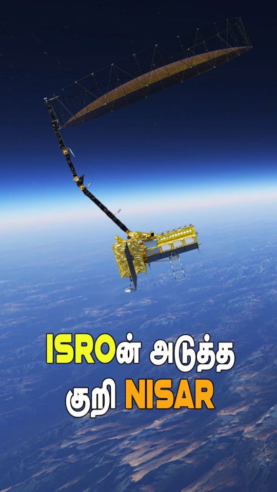
#NISAR#NASAISROCollaboration#EarthObservation#SpaceScience#SatelliteTechnology#GIS#RemoteSensing#ClimateChangeResearch#Geospatial#ScienceInSpace#SatelliteLaunch#ISRO#NASA#SpaceExploration#EnvironmentalMonitoring
0 notes
Text
Geoserver: A comprehensive overview of Spatial datasets and web services
GeoServer is open-source software for sharing, processing and creating web services for geospatial data. It plays a vital role in geospatial information systems (GIS) and web mapping applications.
Here's a comprehensive view of Geoserver-
Geospatial Data Support: GeoServer handles diverse geospatial formats, encompassing both vector and raster data.
Web Service Standards: It complies with web service standards like WMS, WFS, WCS, and WMTS, facilitating geospatial data sharing and web visualization.
WMS (Web Map Service): It serves customizable maps (PNG, JPEG) with dynamic rendering based on user requests.
WFS (Web Feature Service): WFS enables querying, retrieval, and editing of geographic features, allowing vector data access and manipulation.
WCS (Web Coverage Service): GeoServer distributes raster data (e.g., GeoTIFF or NetCDF) via WCS, facilitating user access to coverage data.
WMTS (Web Map Tile Service): It supports WMTS for efficient pre-rendered map tiles in a consistent grid, enhancing web mapping application performance.
RESTful Services: Ita offers a RESTful API for developers and custom apps to access geospatial data and services via HTTP requests.
Data Styling and Symbology: Users can customize data layer styles with GeoServer using the flexible Styled Layer Descriptor (SLD) standard.
Security and Access Control: GeoServer secures data and services through access control, supporting authentication and authorization to restrict access to authorized users.
Data Reprojection: GeoServer on-the-fly reprojection serves data in various coordinate reference systems (CRS) to meet client needs
Data Versioning and Publication: GeoServer supports dataset versioning for data integrity and history tracking.
Community and Ecosystem: GeoServer boasts a vibrant user community offering support, docs, and plugins for extended functionality
Scalability: GeoServer is versatile, suiting single servers to distributed setups, effectively managing high data volumes and requests.
Interoperability: GeoServer is compatible with GIS software and can be combined with tools like QGIS, OpenLayers, and Leaflet.
Extensibility: Extensible via plugins and custom code for added functionality and data format support.
GeoServer is a powerful tool for organizations and developers looking to share and publish geospatial data on the web and build web mapping applications.
0 notes
Text
GIS Data Viewer In Leaflet JS — For Standalone & Offline Use
GIS Data Viewer In Leaflet JS — For Standalone & Offline Use https://medium.com/towardsdev/gis-data-viewer-in-leaflet-js-for-standalone-offline-use-758ed2abe1a7
Runs entirely in client-side JavaScript. Supports GeoJSON, KML and SHP spatial data formats.
#geospatial#web app#maps#leaflet#javascript#web application development#technology#tech#programming#productivity#geoscience#dataviz#data analytics
0 notes
Text
Geoinformatics Colleges in India: A Comprehensive Guide
Are you passionate about geospatial technology and its applications? Do you want to pursue a career in geoinformatics? If so, you've come to the right place! In this article, we will explore the top geoinformatics colleges in India and provide you with all the information you need to make an informed decision about your future.

What is Geoinformatics?
Before we dive into the details of geoinformatics colleges in India, let's first understand what geoinformatics is all about. Geoinformatics is an interdisciplinary field that combines geography, geology, computer science, and information technology to analyse and interpret spatial data. It involves the use of various tools and techniques to collect, store, process, analyse, and visualise geographic information.
Courses offered for Geoinformatics
If you're interested in pursuing a career in geoinformatics, it's important to know what courses are available and what they entail. Here are some geoinformatics course details offered by geoinformatics colleges in India:
1. Bachelor's Degree in Geoinformatics
A bachelor's degree in geoinformatics is the first step towards building a successful career in this field. This course typically spans over three to four years and covers a wide range of topics such as GIS (Geographic Information System), remote sensing, spatial analysis, database management, and cartography. Some colleges also offer specialised courses in areas like environmental management and urban planning.
2. Master's Degree in Geoinformatics
If you want to further enhance your knowledge and skills in geoinformatics, you can pursue a master's degree in this field. A master's degree program usually lasts for two years and provides advanced training in areas such as geospatial data analysis, geodatabase design, web mapping, and geospatial programming. Many colleges also offer research opportunities for students who wish to delve deeper into specific topics.
3. Diploma/Certificate Courses
Apart from bachelor's and master's degree programs, there are also several diploma and certificate courses available for those who want to gain specialised knowledge in specific areas of geoinformatics. These short-term courses focus on topics such as remote sensing applications, GIS software, and spatial data analysis.
Top Geoinformatics Colleges in India
Now that we have a basic understanding of geoinformatics and its course details, let's take a look at some of the top geoinformatics colleges in India:
Indian Institute of Remote Sensing (IIRS)
Indian Institute of Remote Sensing (IIRS), located in Dehradun, Uttarakhand, is another renowned institute that offers excellent programs in remote sensing and geoinformatics. The institute is affiliated with the Indian Space Research Organization (ISRO) and provides world-class training and research opportunities to students.
National Institute of Technology (NIT) Warangal
National Institute of Technology (NIT) Warangal offers a comprehensive program in geoinformatics at both undergraduate and postgraduate levels. The institute has state-of-the-art facilities, well-equipped laboratories, and experienced faculty members who are actively involved in research projects.
Symbiosis Institute of Geoinformatics (SIG)
Located in Pune, Maharashtra, SIG is one of the premier institutes for geoinformatics education in India. It offers a variety of undergraduate, postgraduate, and diploma programs in geoinformatics. The institute has a state-of-the-art infrastructure, experienced faculty members, and strong industry connections, making it an ideal choice for aspiring geospatial professionals.
Scope of Geoinformatics
After completing your education in geoinformatics, you'll have a wide range of career opportunities to explore. Here are some possible MSc geoinformatics scopes:
1. GIS Analyst: As a GIS analyst, you'll be responsible for collecting, analyzing, and interpreting geographic data using GIS software.
2. Remote Sensing Specialist: Remote sensing specialists use satellite imagery and other remote sensing techniques to gather information about the Earth's surface.
3. Spatial Data Scientist: Spatial data scientists analyze spatial data using statistical techniques to derive meaningful insights.
4. Urban Planner: Urban planners use geospatial technology to develop plans for land use, transportation systems, and urban development.
5. Environmental Consultant: Environmental consultants assess the impact of human activities on the environment using geospatial tools.
These are just a few examples of the career paths you can pursue with an MSc degree in geoinformatics. The demand for skilled professionals in this field is growing rapidly, both in India and abroad.
Conclusion
Geoinformatics is a fascinating field that offers exciting career opportunities for those who are passionate about spatial data analysis and interpretation. By pursuing a degree in geoinformatics from one of the top colleges mentioned above, you’ll gain the necessary knowledge and skills to excel in this field. We recommend SIG from Pune as it offers the perfect blend of education and experience you need for your career ahead.
Remember to thoroughly research each college’s curriculum, faculty expertise, infrastructure, and industry connections before making a decision. Good luck with your academic journey!
1 note
·
View note
Last Seen Blogs

welton-academy-official
tradition. honor. discipline. excellence.

roussohoes
VANESSA WAS ROBBED

bambylamby
nano◕ ‿ ◕✿

nuggetynoodle
Peachy Keen

pinolaphoto
Untitled