#twittersourced
Photo

The Most Popular Grocery Store In Each State (in 2022, based on foot traffic)
by @statspanda1
11K notes
·
View notes
Photo

The pilot of this Finnair flight made a 360 turn to allow everyone onboard see the fantastic Northern Lights last night.
https://www.flightradar24.com/data/flights/ay488#2f563bb5
by @flightradar24
8K notes
·
View notes
Photo
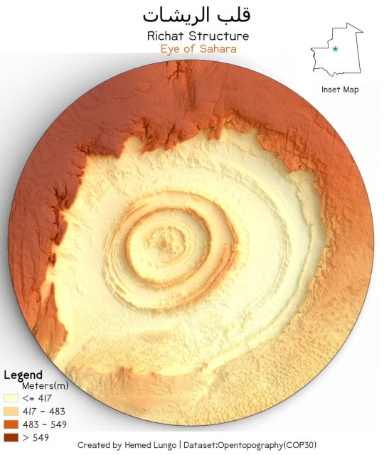
Richat Structure/Eye of Sahara (قلب الريشات) Adrar Plateau, Mauritania 🇲🇷
by @725Hemeed
4K notes
·
View notes
Photo
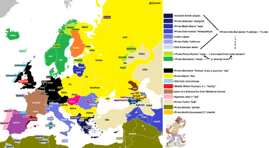
The word for 'fox' in European languages.
by @Oysteib
Quite an enormous difference in the present words that (may?) come from the same Indo-European root - from 'aghves' to 'rubah' to 'volpe'. And, apparently, this may be a word that the Nordic languages got from Uralic languages...
1K notes
·
View notes
Photo

Terrain Model of Poland (Polska) 🇵🇱.
by @725Hemeed
1K notes
·
View notes
Photo

Intersections of Boston.
by @barelymaps
3K notes
·
View notes
Photo


Work of Japanese artist Takahiro Iwasaki who makes maps and city plans by sculpting duct tapes.
3K notes
·
View notes
Photo
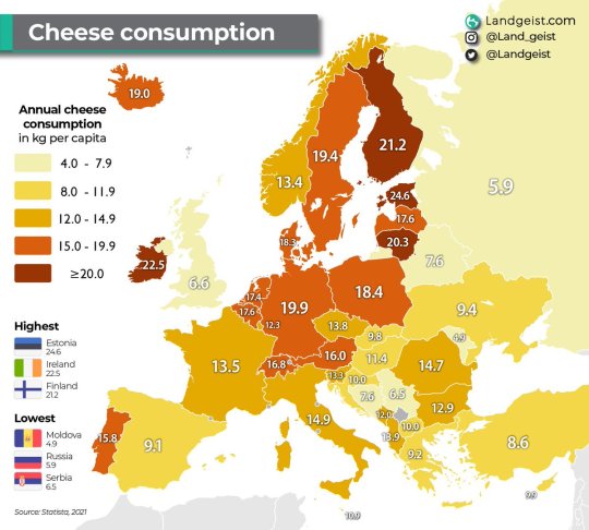
Per capita cheese consumption in Europe.
Full article >>
1K notes
·
View notes
Photo
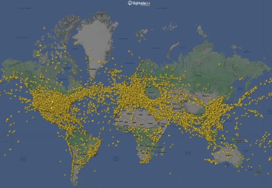
22,000 flights in the air, topping the most FlightRadar24 have ever tracked at one time.
Yesterday they tracked more than 253k flights, another new single day record.
by @flightradar24
628 notes
·
View notes
Photo
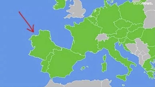
“I’m sure Americans don’t even know the name of this country,” Twitter user Gaspardo said on 30 October, accompanying a map with a red arrow pointing at the slab of land liberally added to Spain and Portugal and coloured green, implying this was an EU member state.
by @euronews
2K notes
·
View notes
Photo
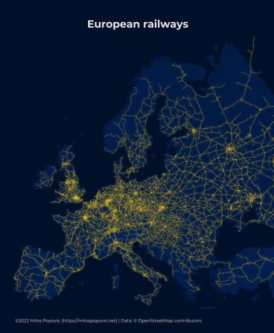
Active railways in Europe according to OpenStreetMaps (OSM) data.
by @milos_agathon
2K notes
·
View notes
Photo
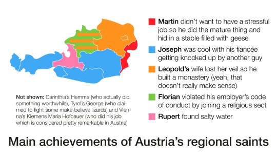
Main achievements of Austria’s regional saints
by @austrianmaps
549 notes
·
View notes
Photo
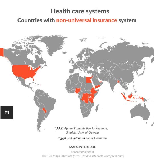
Health care Systems. Countries with non-universal insurance system
by @Maps_interlude
818 notes
·
View notes
Photo

South America elevation tile map.
by @cstats1
1K notes
·
View notes
Photo
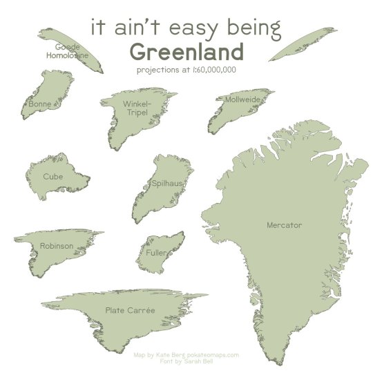
Exploring out how Greenland looks in ten different projections.
by @pokateo_
1K notes
·
View notes
Photo
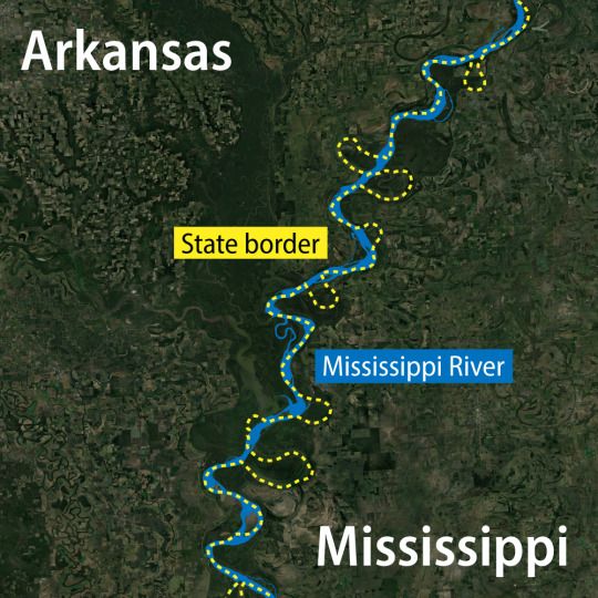
Geography lesson for future state makers: rivers make terrible borders over time! Rivers change over time and because of that we see portions of Arkansas and Mississippi extending over the river.
by @GeographicGeoff
705 notes
·
View notes
Last Seen Blogs

poetryydaydreams
folkwhore

recyclereu
E-schrott Recycling

osgiliathh
teenagers with attitude

peterlandau
Love and Other Bodily Fluids

rajasthangoldsatta1
Rajasthan gold satta