#ancient map
Text

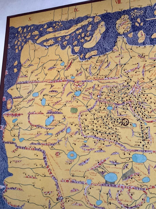
Ancient map- Clementoni 2000 pieces
2 notes
·
View notes
Text
1 note
·
View note
Text
#world map#vintage map#compass design#travel motif#explorer pattern#wanderlust#adventure#globetrotter#travel enthusiast#ancient map#world explorer#journey design#travel gift#travel pattern#map pattern
0 notes
Text
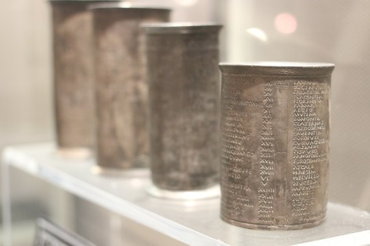
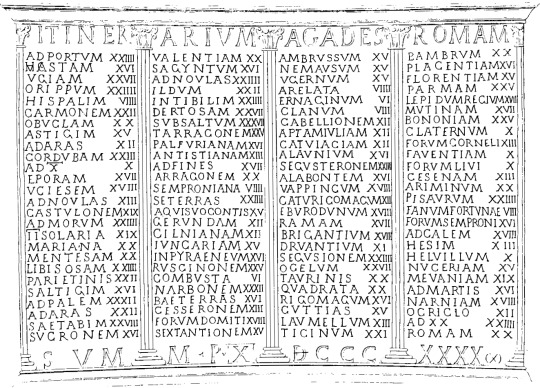
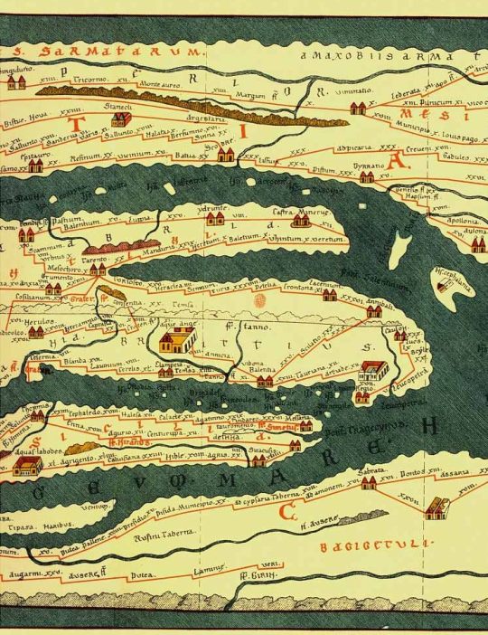
The most common geographical evidence we have from ancient Rome are catalogs of places. Roman maps, to the extent that they existed at all, were almost certainly rare and expensive. Ordinary Romans would not have had access to them. Instead, Romans would have used itineraria, which are just what they sound like — lists of the places a traveler might encounter along a certain road. Many itineraria are catalogs of the milestones that the Roman government placed on its road network.
One of the more famous itineraries is found on a set of cups that were excavated in Vicarello; they describe the route from Cadiz, Spain to Rome.
{WHF} {Ko-Fi} {Medium}
2K notes
·
View notes
Text
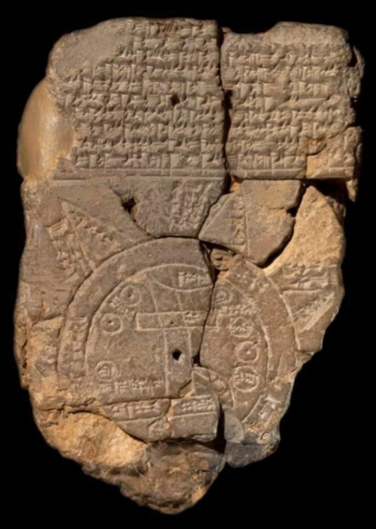
Babylonian Map of the World (6th century BC), also known as Imago Mundi, is oldest clay tablet map written in Akkadian.
The tablet describes the oldest known depiction of the known world.
It was discovered at Sippar, southern Iraq, 60 miles north of Babylon on east bank of Euphrates River.
This map not only serves as a historical record of the region's geography but also includes mythological elements, providing a comprehensive view of the ancient Babylonian worldview.
Today, the Babylonian Map of the World is housed in the British Museum, where it continues to be a valuable artifact for understanding the ancient past.
Details of the map:
1. “Mountain” (Akkadian:šá-du-ú)
2. “City” (Akkadian: uru)
3. Urartu (Armenia) (Akkadian: ú-ra-áš-tu)
4. Assyria (Akkadian: kuraš+šurki)
5. Der (Akkadian: dēr)
6. Swamp (Akkadian: ap–pa–ru)
7. Elam (Akkadian: šuša)
8. Canal (Akkadian: bit-qu)
9. Bit Yakin (Akkadian:bῑt-ia-᾿-ki-nu)
10. “City” (Akkadian: uru)
11. Habban (Akkadian: ha-ab-ban)
12. Babylon (Akkadian: tin.tirki), divided by Euphrates
13. Ocean (salt water, Akkadian:idmar-ra-tum)
#Babylonian Map of the World#Imago Mundi#clay tablet map#clay tablet#Akkadian#Sippar#Iraq#British Museum#history#mythology#map#Archaeo Histories#Ancient Babylon#Babylonia#geography#artifact
524 notes
·
View notes
Photo
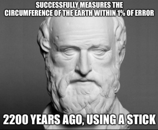
Eratosthenes of Cyrene
He is best known for being the first person known to calculate the circumference of the Earth, which he did by using the extensive survey results he could access in his role at the Library; his calculation was remarkably accurate. He was also the first to calculate Earth's axial tilt, which has also proved to have remarkable accuracy. He created the first global projection of the world, incorporating parallels and meridians based on the available geographic knowledge of his era..
Read more: https://en.wikipedia.org/wiki/Eratosthenes
#Eratosthenes#ancient greece#ancient history#history#greece#geography#maps#earth science#Earth#science
1K notes
·
View notes
Photo
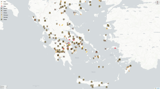
Ancient Greece temples map
Interactive map: https://digitalhistory.io/visualizations/ancient-greece-temples-map
99 notes
·
View notes
Text
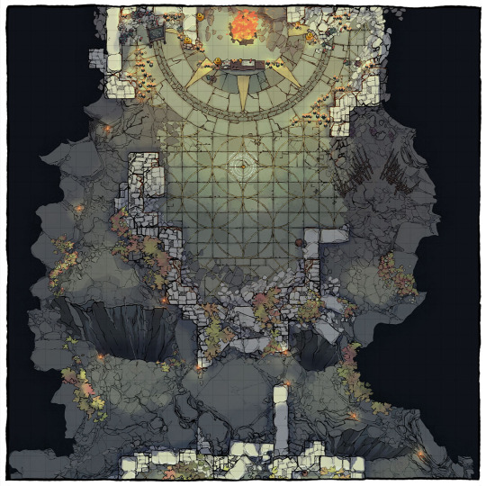
The Buried Temple Battle Map
You can now download our new Buried Temple: a 32x44 complex leading up to a magic-infused boss room! Tell me, what might make this their lair?
→ Download it here!
#ttrpg#tabletop#dungeons and dragons#dnd#dungeons & dragons#d&d#d&d5e#pathfinder#gurps#rpg#top-down#battle map#map#cartography#encounter#cave#temple#magic#ancient#ruins
220 notes
·
View notes
Text
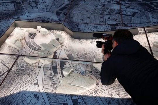
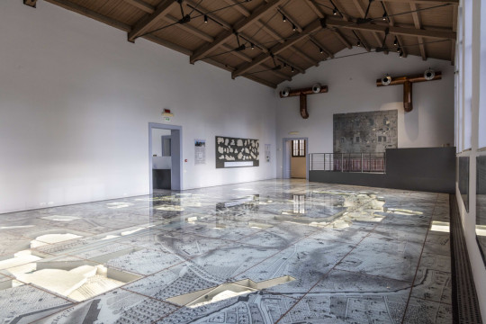
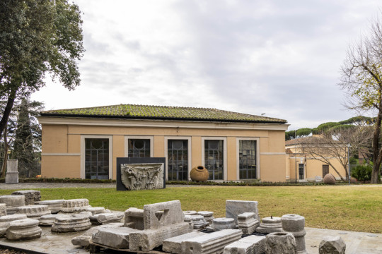
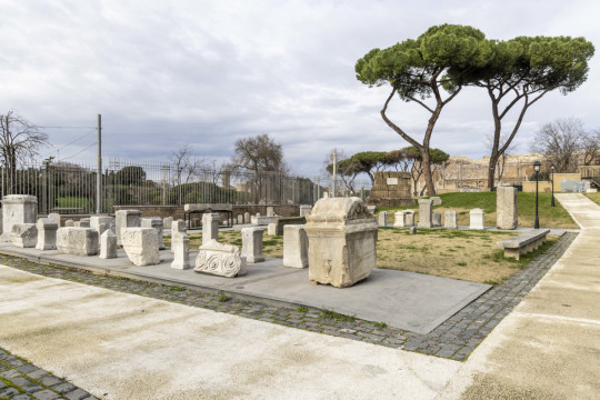
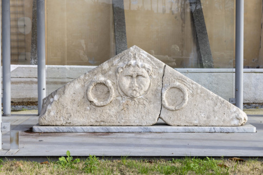
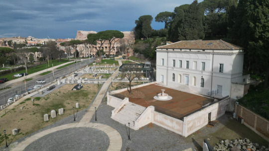
Ancient Monumental Marble Map of Rome on Display After 100 Years
A marble map of ancient Rome, that hasn't been put on public view for almost 100 years, is getting its very own museum within sight of the Colosseum.
The Museum of the Forma Urbis, enclosed within a new archaeological park on one of Rome's famous seven hills opens on Friday -- the latest offering from a city that is eager to broaden its attraction for growing hordes of tourists, according to Reuters.
"This is a beautiful day. We are opening an archaeological park in an extraordinary part of the city and a new museum showcasing a masterpiece which has not been visible for about a century," said Rome Mayor Roberto Gualtieri.
"We want a city where the museums and the streets are linked, and where people, while walking around, can fully appreciate and enjoy the beauty, but also better understand how our city has been transformed."
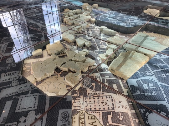

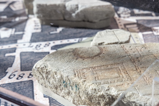
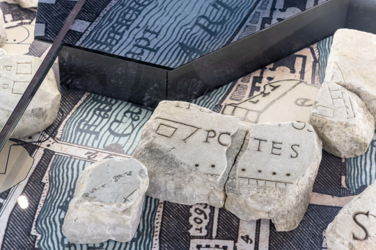
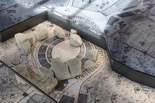
The Forma Urbis was a monumental, highly detailed marble map of ancient Rome carved during the reign of the Emperor Septimius Severus between 203 and 211 AD, engraved onto 150 separate slabs and measuring 18 by 13 metres (60 by 43 feet).
It was displayed on a wall in the ancient city, but over the centuries it gradually disintegrated, with locals using some slabs for new buildings.
During excavations in 1562, fragments were recovered and scholars estimate around 10% of the whole has survived, including sections showing the Colosseum and Circus Maximus, as well as floor plans of baths, temples and private houses.
The huge carving has proved a valuable resource for understanding the layout of ancient Rome, but all the remaining pieces have not been shown together since 1924.
In its new, innovative setting, the fragments have been laid out on a reproduction of a famous map of Rome created in the 18th century by the surveyor Giovanni Battista Nolli, who is credited with making the first accurate street plan of Rome.
The marble chunks lie on top of the Nolli map, showing their relation to the developing Renaissance city.

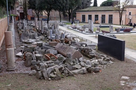
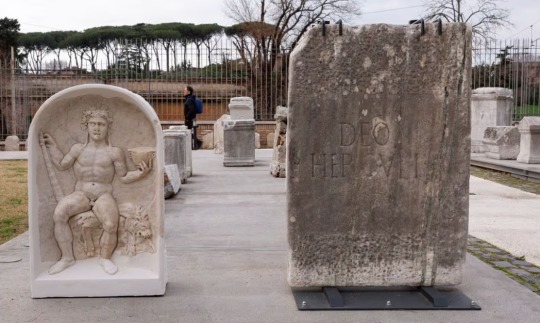
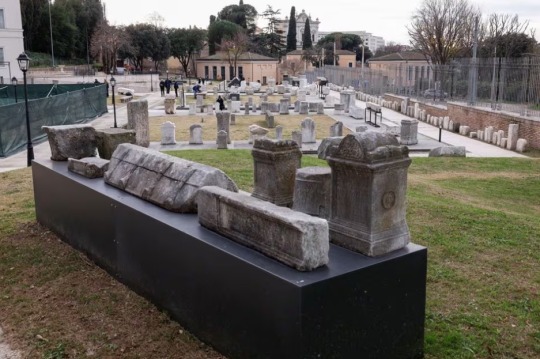
Outside the museum, in the open-air park on the side of the Caelian Hill, archaeologists have out laid out walkways lined with ancient Roman grave markers and marble columns found in excavations around the city in recent decades.
"The Caelian Hill, one of the seven hills of ancient Rome, has remained in the shadows, unknown and inaccessible for a very long time. Today, we are finally giving it back to the city," said Claudio Parisi Presicce, who oversees Rome's cultural heritage.
"The hill has a special importance because it is what unites the monumental area of the Imperial Forums, the Roman forum, the Colosseum and the area of the Appia Antica," he said.
The 5-million-euro ($5.5 million) project is part of a broader refurbishment of Rome, which has seen a tourism boom since the end of the COVID-19 pandemic and is expected to be submerged by visitors in the 2025 Roman Catholic Holy Year.

#Ancient Monumental Marble Map of Rome on Display After 100 Years#The Museum of the Forma Urbis#The Forma Urbis#Emperor Septimius Severus#ancient artifacts#archeology#archeolgst#history#history news#ancient history#ancient culture#ancient civilizations#ancient rome#roman history#roman empire#roman emperor#roman art
153 notes
·
View notes
Text
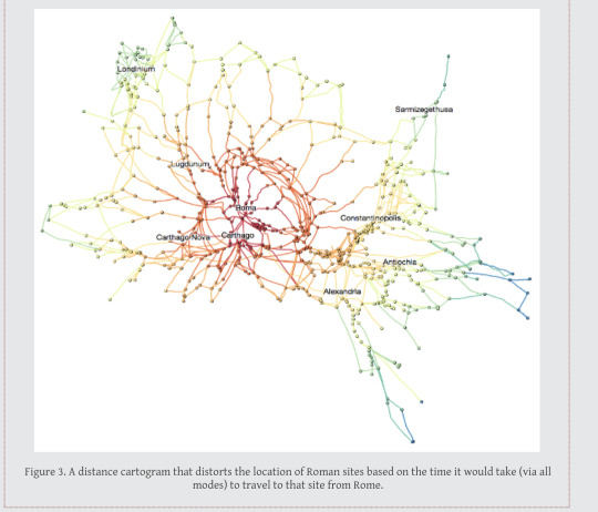
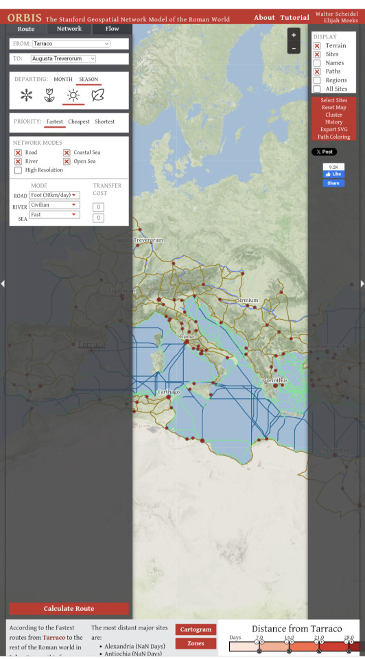
Geospatial model of the Roman World.
Want to know how long it would take to get from what is now Yorkshire to Rome in the first century? And the best route? And the expense?
If you are a historical novelist and you haven’t encountered this interactive site, you need to. It’s centered on the Roman Empire, but with care this info will translate to other eras.
#roman empire#ancient rome#interactive#maps#classical studies#medieval studies#travel#history#historical fiction
90 notes
·
View notes
Text

#ancient egypt#ancient#giza#egyptian#egyptology#pyramids#egypt tours#egypt#ancient history#history tag#archaeology#anthropology#world history#culture#history#cartography#map#library
191 notes
·
View notes
Photo
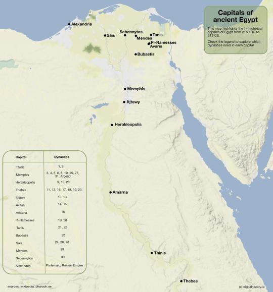
Capitals of Ancient Egypt
98 notes
·
View notes
Text
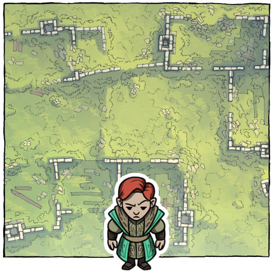
The Lost Elven Capital
A buried elven castle emerges from the earth, promising untold riches and shrouded in ancient mysteries. Can you navigate the treacherous ruins and uncover the secrets of a lost civilization?
→ Find the full adventure (with bonus battle map) here:
#ttrpg#tabletop#dungeons and dragons#dnd#dungeons & dragons#d&d#d&d5e#pathfinder#gurps#rpg#top-down#battle map#map#cartography#encounter#geomorph#dungeon#castle#ancient#unburied#uncovered#lost#discovered#elven#dwarves#library#destroyed#burned
40 notes
·
View notes
Photo
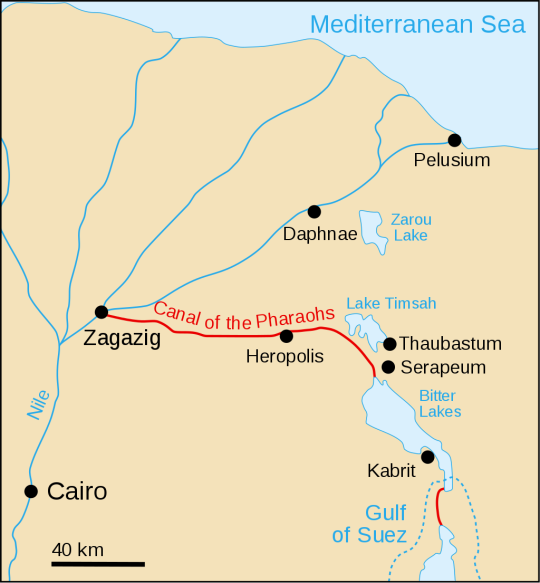
Before Suez Canal, there existed Canal of the Pharaohs, closed in 767 CE.
212 notes
·
View notes
Last Seen Blogs

budvsbhavnagar
BUDVS Bhavnagar SPNF Producer - FPO's

florally-fathomed
Florally Fathomed

playstationgifs
PlayStation GIFs

acourtofelriels
Elriel Supremacy

twisted-sands
Twisted Sands