#interactive maps
Photo

World population density map
Zoomable map >>
161 notes
·
View notes
Text
Top 5 Benefits of Interactive Maps in 2024
In the fast-paced digital landscape of 2024, interactive maps have emerged as indispensable tools that go beyond traditional boundaries. In this blog post, we will delve into the top five benefits of interactive maps, focusing on the prowess of map builder and their transformative impact on real estate. Along the way, we'll introduce you to Mapme, an online platform designed to make map creation a breeze.
1. Revolutionizing Map Creation with Map Builders:
The landscape of map creation has evolved significantly with the advent of sophisticated map builders. These tools, such as the user-friendly platform Mapme, empower individuals and businesses to effortlessly create stunning and dynamic interactive maps. With drag-and-drop functionalities and customizable templates, map builders are democratizing cartography, allowing users to bring their visions to life without the need for extensive technical expertise.
2. Engaging Users with Interactive Maps:
In the dynamic world of 2024, interactive maps have proven to be highly engaging across diverse industries. Whether you're planning a trip, exploring a new neighborhood, or seeking a map for real estate options, interactive maps provide a visually compelling and informative experience. Users can zoom in, click on specific points of interest, and access relevant information, making the exploration both interactive and enjoyable.
3. Real-Time Data Integration for Informed Decisions:
The demand for real-time information is paramount in 2024, and interactive maps rise to the occasion. Map builders, including Mapme, facilitate the seamless integration of up-to-the-minute data. This feature is particularly beneficial for real estate professionals, enabling them to create maps for real estate showcasing property listings with current availability and pricing. The ability to integrate real-time data enhances decision-making processes and fosters transparency between stakeholders.
4. Facilitating Collaboration through Map Creation:
Collaboration lies at the core of successful ventures, and interactive maps streamline communication among team members and stakeholders. Mapme, a prime example, offers collaborative features that enable multiple users to work on a map simultaneously. In real estate, teams can collectively create and update property maps, ensuring everyone is on the same page and contributing to project success.
5. Strategic Marketing with Interactive Real Estate Maps:
In the real estate industry, the impact of interactive maps is revolutionary. The ability to create visually appealing and informative maps enhances property marketing efforts significantly. Prospective buyers or tenants can explore neighborhoods, view property details, and even take virtual tours—all through interactive maps. Mapme's intuitive platform facilitates real estate professionals in creating maps for real estate, showcasing properties in a visually stunning and informative way, attracting more attention and potential clients.
In conclusion, the benefits of interactive maps in 2024 are vast and transformative. Thanks to advanced map builders like Mapme, individuals and businesses can harness the power of interactive maps to enhance user engagement, integrate real-time data, facilitate collaboration, and revolutionize marketing efforts, particularly in the dynamic landscape of real estate. As we navigate the future, interactive maps will undoubtedly continue to redefine the way we interact with our surroundings and information.
0 notes
Text
watching the sdcc panel and i am just very :) about how sweet their answers to “what are some of the micro moments from the game that have stuck with you the most over the years?” are. taliesin saying what the fuck is up with that which was the first like The Party Gets To Know Each Other moments of c3. travis saying asking his wife if he could kiss her in campaign. marisha going way back to the cannonball competition in campaign one. ashley choosing the beauyasha date but also just the silly goat noise matt made. liam adding onto that to compliment matt roleplaying grass so well and then saying his favourite moment was writing a story for laura and reading it to her as caleb for jester. and then matt saying that was his answer, and that his favourite moments of the game are when they find ways to give gifts to each other whether tangible or not. and sam saying his favourite moments have less to do with the story and is more so when he can just. see his friends across the table from him. when marisha perches and when laura and ashley are (badly) drawing dicks and liam saying he loves when sam sneezes and ashley tells him to stop it and just. yeah. they Are an extremely popular online powerhouse, but i’m so happy that they’re also friends building a world together out of gifts to and love for one another.
like i Am so enamoured with the characters and the world of exandria but the moments when you can feel the love that those people have for each other reach out from behind the stained glass of their performances (to steal a metaphor from brennan lee mulligan) are so extremely special and i am endlessly grateful that they decided to share their silly little home game with the world.
#it’s just the. laura and travis’ characters always being supportive of one another when they’re facing hardship#taliesin and marisha consistently making characters who challenge one another and still protect each other relentlessly#all of them being so fond of ashley’s characters always and literally seeing them light up in c1 episodes when ash got to join in person#sam and liam always making characters who offer one another reprieves into kindness that they don’t always get in the campaign setting#liam making orym after falling in love with keyleth as vax#marisha making laudna after matt’s storytelling with delilah and choosing vex as her body double#ashley using ‘i would like to rage’ and matt having kord ask her where she finds her strength#laura and matt always weaving these deeply complicated and emotional interactions between a daughter and a father#the gasps and yells and clapping when matt makes cool sound effects or reveals a map or breaks/ends on a cliff hanger#them ending both campaign 1 and 2 with ‘what a great/nice story’ and travis saying ‘let’s do it again!’#and it’s like. yes yes i love the comics and i’m a fan of tlovm but . seeing this well produced thing that somehow mimics#the feeling i get sitting in my living room laughing with my roommates about my ranger’s giant rat failing to climb stairs#it’s very special it’s very sweet#critical role#sdcc 2023#taliesin jaffe#travis willingham#marisha ray#ashley johnson#liam o’brien#matthew mercer#laura bailey#sam riegel#cr cast#critical role cast#my posts
3K notes
·
View notes
Text
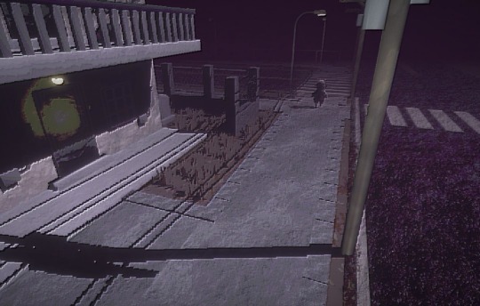

in this house we love fixed camera angles and terrible graphics
#basic map done yippeeeeee#still tons of work to do though#collision interaction ambience additions fixes etc etc etc#game dev#3d art#3d model#low poly#uwaugh
2K notes
·
View notes
Text
I've been looking for a good interactive map for Cyberpunk 2077 for years now. Some are just really low quality while others are outdated.
But today I found the best interactive map ever made. And on reddit of all places
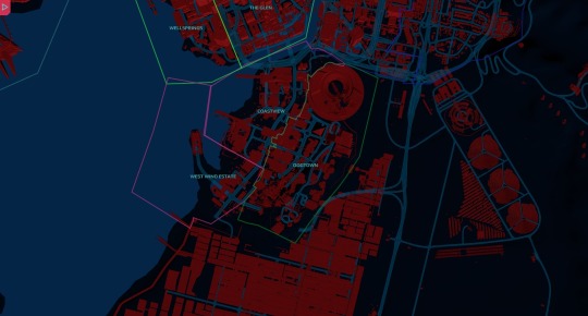
I mean that's a fairly clean and crisp map, but it gets better.
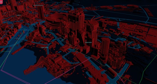
Unlike every interactive map I've ever come across, this is not a selection of images, but a full 3D model of the in-game map, that you can move around and zoom in.
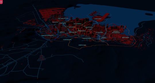
If only the one in the game was this easy to use.
Oh also, one of the comments on that post introduced me to the Night City Geoguesser
It's a fun spin on geoguesser since I know where most of these places are. Highest score I got was 4264. Which puts me No. 8 on this months leaderboard.
218 notes
·
View notes
Text
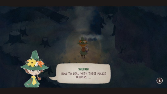
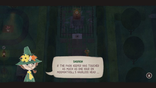
Snufkin quotes for the tumblrtrolls
#snufkin: melody of moominvalley#snufmin#moomins#snufkin#it's a bit of a baby game but sometimes the puzzles have more steps than “move forward interacting with each thing”#and the area maps are windey enough to feel big#teety-woo is the tutorial goblin as they deserve for being a SIMP!#they big-upped Sígur Ros' contribution but I'm not sure there's more than one or two songs from that#I'm like 2.5 hours in and maybe ⅔ done with the plot? there's mild sidequest and collection as well#i guess since I've not talked to snorkmaiden maybe I'm less than ⅔ done
226 notes
·
View notes
Text
Btw
HAPPY NΣCRØ PRIDE DAY YALLLL !!!!!


EDIT:
This day is on the 17.04 ^^
#necro safe#necro pride#pro necro#autonecrophilia#necromap#necrozoo#rq 🌈🍓#dead love#dead lover#corpse lover#coprse love#pro paraphile#paraphiles please interact#paraphile safe#paraphilia#para safe#paraphile community#pro para#maps rights :3#pro zoo#lgbtqiaapx+#radqueer#queer#rqc🌈🍓#pro rq 🌈🍓#rqc 🌈🍓#radqueer 🌈🍓#radqueer 🍓🌈#rqc 🍓🌈#🍓🌈 safe
148 notes
·
View notes
Photo


Training sketches to know to draw the Omnic “Moses” and... I had fun giving it more human expressions (the ironyyyyyyyyyyyyyyyyyyyy !🤣)
#Overwatch#Overwatch 2#OW2#Fanart#Sketch#Ramattra#Their curiosity is so fascinating !#Let them have interactions that enrich their thirst for knowledge and understanding of the world !#I'm sure he would get along with Sigma !!!#Why don't they interact ? Blizzzzzzzzzzzard TT#I can imagine them being so focused on ants for hours#They looks like a lion from the way I drew them X''D#However the third sketch's so OCC but funny#This is just my reaction when:#One: The game servers crash in the middle of a (competitive) game - someone or me is kicked out#Two: When I play badly as a Tank (bc I'm not the best and I know it --'')#- I get insulted (in voice or in the chat) by my teammates and they suck more than me#Three: When I'm on a map I hate A LOT#To lighten the mood a bit I'll give you one of the nicknames I give to Ramattra#The Husbanbot#I want this tag to become official ! X''D
2K notes
·
View notes
Text
Ough tomorrow if ppl are interested i can talk abt my new oc ideas from today bc Im actually really excited about them 👉👈
#thunderclap#i know I can't draw as fast or as much anymore but hopefully i can show stuff soon even if its from my sketchbook#which ive taken up again at least for a little bit#i have plans for HR that I mentioned earlier today and i also have plans for CD that Im really hyped about including a bunch of design#tweaks and i also started working on a new map for it too! which im really excited about bc I'm putting more thought into it#and im gonna change graves' hairstyle too and im rly excited for that as well#and also back to HR im really hyped to be putting the other ocs in it and having everyone fight and interact it really fit so well instantly#its actually making me crazy like if this works im gonna feel like such a huge genius fr
134 notes
·
View notes
Text
i personally think marcille is bisexual but in the "i am attracted the Occasional anime twink and also every woman who has ever walked the earth" way. like a solid 5 on the kinsey scale, y'know?
#eliot posts#(yes the kinsey scale is outdated and a vast oversimplification plus doesn't map perfectly onto modern label uses but. yk.)#dunme#dungeon meshi#marcille donato#i am only extrapolating a little bit from canon here#gestures at the succubus chapter#and then gestures at how the Vibes feel a little bit gay to me whenever she's interacting directly w almost any other adult woman#it's odd to me that i very rarely see ppl headcanon her as bi unless they are actively shipping her w a man (usually chilchuck or laios)#i personally ship her exclusively w falin (to me chilchuck is her work dad and laios is her boybestie and future in-law)#but she is simply bi and dating a woman to me#(now falin on the other hand i personally generally see as a lesbian)#(that ''she almost accepted toshiro's proposal bc she was worried no one else would want her. but hesitated because she felt guilty abt-#-the idea of marrying him even though she did not return his feelings'' read as compulsory heterosexuality to me personally)
85 notes
·
View notes
Text
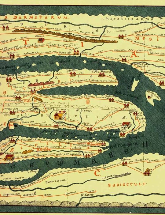
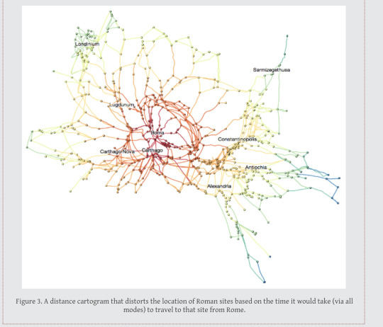
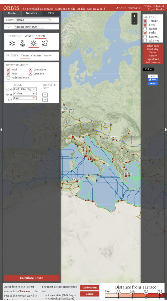
Geospatial model of the Roman World.
Want to know how long it would take to get from what is now Yorkshire to Rome in the first century? And the best route? And the expense?
If you are a historical novelist and you haven’t encountered this interactive site, you need to. It’s centered on the Roman Empire, but with care this info will translate to other eras.
#roman empire#ancient rome#interactive#maps#classical studies#medieval studies#travel#history#historical fiction
90 notes
·
View notes
Photo
Population density ridgeline plot for every country in the world
by u/koen_vde
Interactive tool: https://baryon.be/stories/population/
352 notes
·
View notes
Text
Want to create a map? Design beautiful custom maps with Mapme Editor ; Full design control. Add your own fonts, icons, and textures to make your map fit seamlessly with your brand.
0 notes
Text
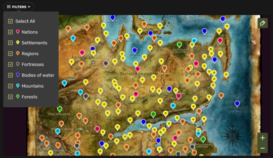
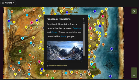
Interactive map of Thedas
Earlier this year, fandom wiki site has introduced the "interactive maps" feature. Now, the Dragon Age wiki has its first fully interactive map!
2K notes
·
View notes
Text
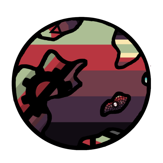
if you click these eyes here in plague on the map they blink every time
353 notes
·
View notes
Text

etho of the slab variety ^-^
inspired by jdebbiel's work!! i love their art style so i decided to try smth similar and mess around w gradient mapping!
#seta art :)#i will not be tagging them bc uhhh interacting with people is spooky scary!! def go check out their acc though it should be linked :D#ethoslab#ethoslab fanart#etho#etho fanart#hermitcraft#hermitcraft fanart#this was fun but god gradient mapping is hard to get used to#its been so long since ive posted ive forgotten what to tag send help
412 notes
·
View notes
Last Seen Blogs

revenge-of-the-shit
Annessarose

snoutenema-blog
Snout Enema

kil9
Taemin's Milkman

keebmyn
Essays about our life.

new-genesis-pso2
新たなる創世の記録