#sedimentology
Photo
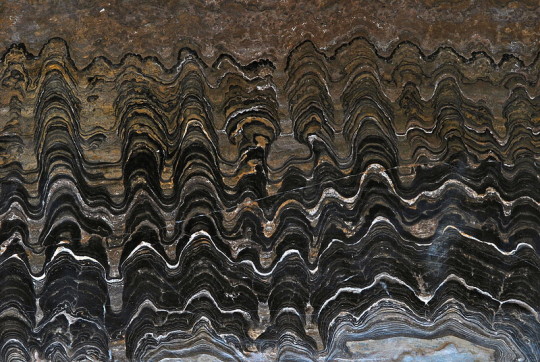
An example of stromatolite, a layered sedimentary formation caused by photosynthetic bacteria. This example is around 2.2 billion years old.
by Bernard Dupont
5K notes
·
View notes
Text
561 notes
·
View notes
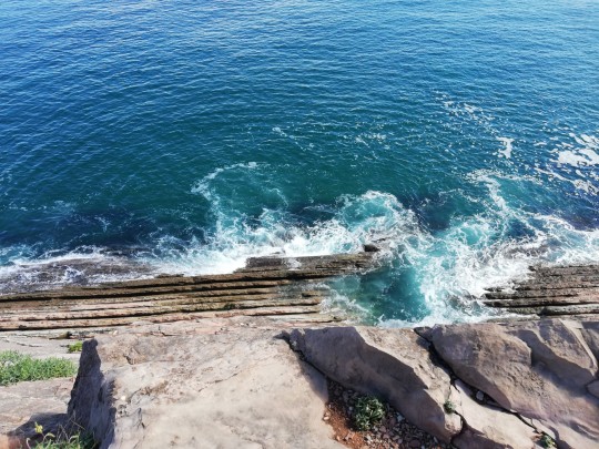
Photo
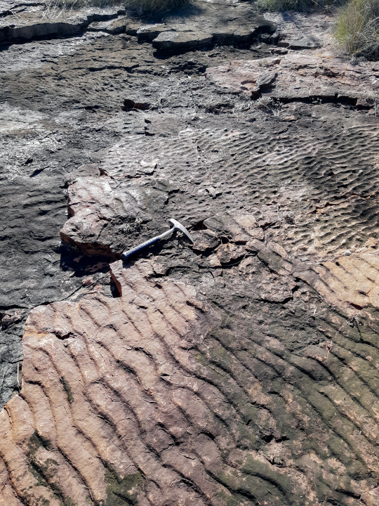
Ripples from ~ 2-bilion-years ago
These ripples are preserved in this sandstone rock and are now lining a dry creek bed in Australian outback. But, it was around 2 billion years ago when motion of water formed these sand ripples on the bottom of a shallow sea. Note that orientation of ripples is different between sedimentary layers which indicates changes to water current direction.
#ripples#geology#rock#outback#sedimentology#geoscience#natural history#ancient#sea#original content#exploring#landscape#science#studyblr#student#drrock
2K notes
·
View notes
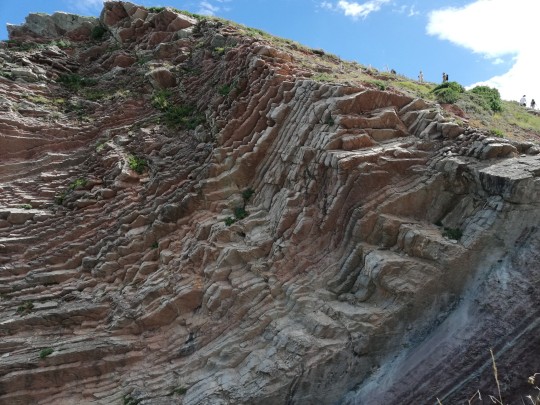
Text
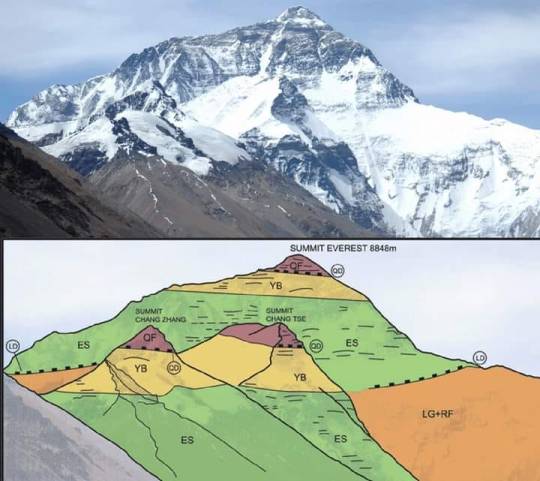
Source: LEARN Geology
𝗠𝗮𝗿𝗶𝗻𝗲 𝗟𝗶𝗺𝗲𝘀𝘁𝗼𝗻𝗲: 𝗧𝗵𝗲 𝗛𝗶𝗴𝗵𝗲𝘀𝘁 𝗥𝗼𝗰𝗸𝘀 𝗶𝗻 𝘁𝗵𝗲 𝗣𝗹𝗮𝗻𝗲𝘁
Everest Range, 𝗡𝗲𝗽𝗮𝗹 and 𝗧𝗶𝗯𝗲𝘁, 𝗖𝗵𝗶𝗻a
27°59'17"N / 086°55'30"E
𝙂𝙚𝙤𝙡𝙤𝙜𝙞𝙘𝙖𝙡 𝙋𝙚𝙧𝙞𝙤𝙙:
Middle 𝗢𝗿𝗱𝗼𝘃𝗶𝗰𝗶𝗮𝗻 (𝗗𝗮𝗿𝗿𝗶𝘄𝗶𝗹𝗶𝗮𝗻)
𝘿𝙚𝙨𝙘𝙧𝙞𝙥𝙩𝙞𝙤𝙣:
Mount Everest is 𝗘𝗮𝗿𝘁𝗵'𝘀 𝗵𝗶𝗴𝗵𝗲𝘀𝘁 𝗺𝗼𝘂𝗻𝘁𝗮𝗶𝗻 above sea level, located in the Mahalangur Himal sub-range of the Himalayas. The China–Nepal border runs across its summit point. Its elevation of 𝟴,𝟴𝟰𝟴.𝟴𝟲 𝗺 was most recently established in 2020 by the Chinese and Nepali authorities.
𝗚𝗲𝗼𝗹𝗼𝗴𝗶𝗰𝗮𝗹 𝗗𝗲𝘀𝗰𝗿𝗶𝗽𝘁𝗶𝗼𝗻:
The 𝘀𝘂𝗺𝗺𝗶𝘁 of Mount Everest, the 𝗵𝗶𝗴𝗵𝗲𝘀𝘁 𝗽𝗼𝗶𝗻𝘁 on Earth, was a 𝘀𝗲𝗮 𝗳𝗹𝗼𝗼𝗿 once. 𝗜𝘀𝗻'𝘁 𝘄𝗼𝗻𝗱𝗲𝗿𝗳𝘂𝗹?. The highest rock on Earth, marking the summit of Mount Everest, are 𝗢𝗿𝗱𝗼𝘃𝗶𝗰𝗶𝗮𝗻 𝗟𝗶𝗺𝗲𝘀𝘁𝗼𝗻𝗲𝘀, deposited in a warm, shallow water sea some 𝟰𝟱𝟬 𝗠𝗮 𝗮𝗴𝗼.
These rocks deposited in an 𝗮𝗻𝗰𝗶𝗲𝗻𝘁 𝗧𝗲𝘁𝗵𝘆𝗮𝗻 𝗢𝗰𝗲𝗮𝗻 were thrust and 𝘂𝗽𝗹𝗶𝗳𝘁𝗲𝗱 into their present commanding position when 𝗜𝗻𝗱𝗶𝗮𝗻 𝗽𝗹𝗮𝘁𝗲 𝗰𝗼𝗹𝗹𝗶𝗱𝗲𝗱 with the 𝗔𝘀𝗶𝗮𝗻 𝗰𝗼𝗻𝘁𝗶𝗻𝗲𝗻𝘁 some 𝟱𝟱 𝗺𝗶𝗹𝗹𝗶𝗼𝗻 𝘆𝗲𝗮𝗿𝘀 𝗮𝗴𝗼.

��𝗙: 𝗤𝗼𝗺𝗼𝗹𝗮𝗻𝗴𝗺𝗮 𝗙𝗼𝗿𝗺𝗮𝘁𝗶𝗼𝗻 (𝗘𝘃𝗲𝗿𝗲𝘀𝘁 𝗹𝗶𝗺𝗲𝘀𝘁𝗼𝗻𝗲𝘀):
It is the un-metamorphosed layer of limestone here called ‘QF’ for 𝗤𝗼𝗺𝗼𝗹𝗮𝗻𝗴𝗺𝗮 𝗙𝗼𝗿𝗺𝗮𝘁𝗶𝗼𝗻, which forms the 𝘀𝘂𝗺𝗺𝗶𝘁 of Everest. It is separated from the underlying Yellow Band layer by a low angle detachment fault.
𝗬𝗕:𝗬𝗲𝗹𝗹𝗼𝘄 𝗕𝗮𝗻𝗱:
This is the layered bedding. It is a limestone, formed from a shallow marine sediment, heated to become a 𝗺𝗮𝗿𝗯𝗹𝗲.
𝗘𝗦: 𝗘𝘃𝗲𝗿𝗲𝘀𝘁 𝗦𝗲𝗿𝗶𝗲𝘀:
It consists of 𝘀𝗲𝗱𝗶𝗺𝗲𝗻𝘁𝗮𝗿𝘆 rock which has been metamorphosed at reasonably high temperatures. It is separated from the underlying layer by a low angle almost horizontal fault.
𝗥𝗙: 𝗥𝘂𝗻𝗴𝗯𝗼𝗸 𝗳𝗼𝗿𝗺𝗮𝘁𝗶𝗼𝗻:
The Rungbok Formation consists of ‘LG’ Leuco- granite and gneiss.RF is a gneiss: rock partly melted and metamorphosed under high temperatures.
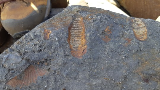
𝙁𝙤𝙨𝙨𝙞𝙡𝙨:
These rocks still contain the fossils of marine animals such as 𝗕𝗿𝗮𝗰𝗵𝗶𝗼𝗽𝗼𝗱𝘀, 𝗖𝗼𝗻𝗼𝗱𝗼𝗻𝘁𝘀 and 𝗖𝗿𝗶𝗻𝗼𝗶𝗱𝘀 that occupied tropical habitats during one of the most 𝗶𝗺𝗽𝗼𝗿𝘁𝗮𝗻𝘁 𝗶𝗻𝘁𝗲𝗿𝘃𝗮𝗹𝘀𝗹𝘀 in 𝗘𝗮𝗿𝘁𝗵'𝘀 history, the 𝗚𝗿𝗲𝗮𝘁 𝗢𝗿𝗱𝗼𝘃𝗶𝗰𝗶𝗮𝗻 𝗕𝗶𝗼𝗱𝗶𝘃𝗲𝗿𝘀𝗶𝗳𝗶𝗰𝗮𝘁𝗶𝗼𝗻 𝗘𝘃𝗲𝗻𝘁 (𝗚𝗢𝗕𝗘).
#himalayan#mounteverest#ordovician#limestone#nepal#india#tibet#indianplate#eurasianplate#geology#thrust#stratigraphy#sedimentology#petrology#structuralgeology#tethys#earthscience#iugs#unesco#geoheritage#knowledge
32 notes
·
View notes
Text
Who on this planet would ever design a second year sedimentology course where ALL of the depositional environments and events are only explained and described in full at the END?!
Anyway wish me luck on this final. Ugh.
4 notes
·
View notes


Text
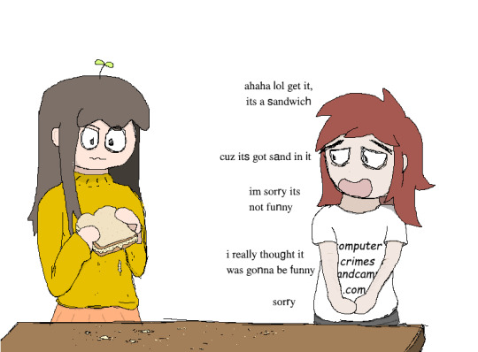
#sandwich#food#foodporn#sand#sandporn#dune#sediment#sedimentology#this was a band some guy i knew a few years ago had. unfortunately idk what happened to him#a lot of these are old comics i made around 2020-2021 but never uploaded publicly
2 notes
·
View notes
Text

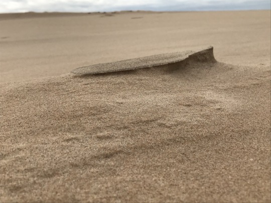


Sand behavior is so odd

So very odd.
Pictures by me.
From Silver Lake State Park Dunes, Mears, Michigan, USA. These dunes were created 1.8MYA, deposited as glacial drift (1).
#throwback#throwback thursday#my photography#sand#geology#sand dunes#sediment#sedimentology#it’s not letting me include a link#why tho?#I wanted to link a source to find out more about Michigan dunes
10 notes
·
View notes
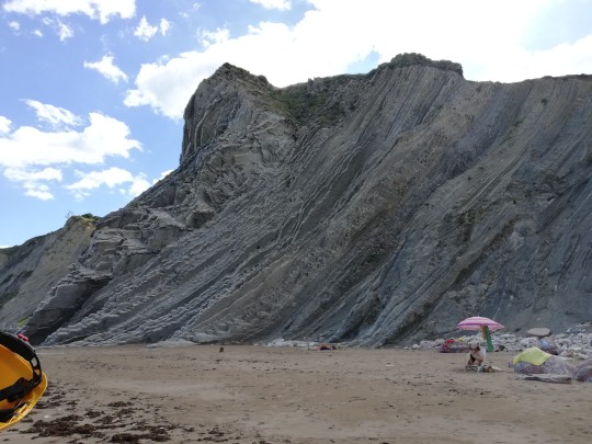
Text
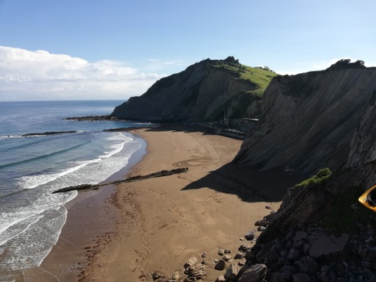
Zumaia beach and it's impressive geology


4 notes
·
View notes
Text
Cheat On Your Wife With Her Buff Sister
Teen spinner Dani Lynn fucked by a big cock
Tickling to Ruined Orgasm. Tease and Denial Edging Handjob. I edged his cock for many times♡
Tio Comendo a Sobrinha Magrinha Sem Camisinha
Curvy amateur strokes and rides cock POV
GayRoom Latino Rub Down Massage Fuck
Nirvana Lust Crazy for Ex Cock
Horny MILF and teen enjoying threesome sex
OBEDIENT chick turning DOGGY STYLE to get fucked DEEPER
BBC BIG BLACK COCK EBONY AMATEURS PUBLIC SEX COMPILATION FOR MARLEY AND ZOEY
#gustoish#creosoting#unalleviating#ornithosis#hawed#Apostolos#loyalize#sedimentology#satinfin#energist#bare-ankled#topsmen#unlugged#multilobular#throatlash#violet-headed#tailfan#self-propellent#workwomanly#anti-Bible
0 notes
Text
Seismic Methods
Seismic methods are based on the study of elastic wave propagation inside the earth. These waves are generated by explosions…Read More »
#education#oil and energy#oil and gas#petroleum#petroleum geology#science#nature#petrophysics#energy#oil and natural gas corporation#seismic#geophysics#geology structural#geology#basin analysis#sedimentology#basin sedimentary
0 notes
Text
Went to the Grand Canyon for spring break, this view made me cry with joy.
14 notes
·
View notes
Photo

Many shapes of fossils (Part 2)
Marine sedimentary rocks are the most common along southern New South Wales coast of Australia. These contain many marine shell fossils in sandstones and siltstones that represent a shallow to deep sea environments from around 250 million years ago.
These creatures would have fed on the organic-rich debris found within the sediment that now surrounds them, and which after many millions of years have turned into a hard rock.
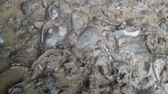

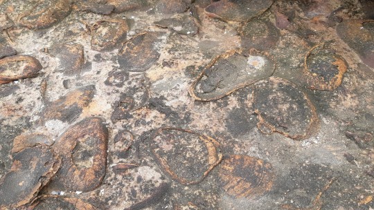
#geology#fossils#paleontology#science#seashells#ancient life#natural history#studyblr#natures beauty#original content#biology#sedimentology#sea#student#drrock
104 notes
·
View notes
Photo

به نام خدا معرفی مجلات علمی و پژوهشی، علمی و ترویجی و ISI رشته زمین شناسی: ✓ Sedimentology √ پیشرو بین المللی در زمینه خود، رسوب شناسی تحقیقات پیشگامانهای را از طیف وسیعی منتشر میکند. رسوب شناسی، زمین شناسی رسوبی و رسوبی ژئوشیمی مناطق تحت پوشش عبارتند از: انتقال تجربی و نظری دانه شارهای رسوبی محیط های رسوبی مدرن و قدیمی چینه نگاری توالی تعامل رسوب و ارگانیسم خاکهای دیرینه دیاژنز ژئوشیمی ایزوتوپ پایدار رسوب شناسی محیطی گروه آموزشی و پژوهشی زمین آزمون #Sedimentology #Geology #ZaminAzmoonGroup #zaminazmoon #Dr_Samadi #Dr_Ramin_Samadi #Geologist #geology_journal #فصلنامه_علمی_پژوهشی #مجله #ژورنال #نشریه #فصلنامه #لیست_مجلات_علمی_رشته_زمین_شناسی #وزارت_علوم #فهرست_نشریات_مجلات_علمی_معتبر_زمین_شناسی #مقالات_علمی_پژوهشی_ژورنال_های_داخلی_رشته_زمین_شناسی #معرفی_مجلات_علمی_پژوهشی_زمین_شناسی #معرفی_مجلات_علمی_ترویجی_زمین_شناسی #معرفی_مجلات_ISI_زمین_شناسی #دکتر_رامین_صمدی #دکتر_صمدی #ایران #زمین_آزمون #زمین_شناسی #زمین_شناس #گروه_آموزشی_و_پژوهشی_زمین_آزمون https://www.instagram.com/p/Cembof3Jat5/?igshid=NGJjMDIxMWI=
#sedimentology#geology#zaminazmoongroup#zaminazmoon#dr_samadi#dr_ramin_samadi#geologist#geology_journal#فصلنامه_علمی_پژوهشی#مجله#ژورنال#نشریه#فصلنامه#لیست_مجلات_علمی_رشته_زمین_شناسی#وزارت_علوم#فهرست_نشریات_مجلات_علمی_معتبر_زمین_شناسی#مقالات_علمی_پژوهشی_ژورنال_های_داخلی_رشته_زمین_شناسی#معرفی_مجلات_علمی_پژوهشی_زمین_شناسی#معرفی_مجلات_علمی_ترویجی_زمین_شناسی#معرفی_مجلات_isi_زمین_شناسی#دکتر_رامین_صمدی#دکتر_صمدی#ایران#زمین_آزمون#زمین_شناسی#زمین_شناس#گروه_آموزشی_و_پژوهشی_زمین_آزمون
0 notes
Text
spent like altogether 1.5 hours preparing for my sedimentary facies analysis exam today and i got 80% on the first part and an objectively middling, but compared to the rest of the results Very Good score in the second part so actually i think i'm invincible and nothing bad will ever happen to me
#not a great time to indulge in hubris i have my basin hydrogeology exam at 8 tomorrow and i'm woefully unprepared#and i generally understand much less of hydrogeology and groundwater flow systems than of sedimentology and sequence stratigraphy#never mind!! i'll start studying after dinner :)#veni veni
13 notes
·
View notes
Text
[Sediment/Sentiment] Fluxes
The Yukon River exports sixty megatons of sediment per year away into the Bering Sea, the majority of it silt and clay derived from the glaciers carving stone at its headwaters. We call this measurement, movement quantified over time, a flux.
I kissed them the night before they left the hemisphere on an exploration geology contract, a two year visa. They study ores, hard rock, mapping what has sat solid in earth for an age, waiting. Their hands were callused already from the heft of samples.
They study ores, and I study fluxes -- water, sediment, salt, ice. My hands are finicky, shaky things, carved for the precision of catching a change in the act. You cannot hold a flux, only bear witness.
I kissed them in a liminal bedroom, half-boxed, walls bared. I took off my binder and we laughed -- oh, fluxes -- at how when they return, we will be changed, both, irrevocably and unavoidably, sure as every river I've known rises each spring and reworks the geometry of its own banks.
To live is to be in flux. It is my honour and joy, queer geologist I am, to bear witness.
We kiss, forehead to forehead, eyes open. Their hand presses into mine, chipped nail polish, calluses blooming. Sixty megatons of sediment, passing through my spread fingers --
They study what stays. I study what leaves.
#creative writing#queer#geology#rocks#writing#sedimentology I suppose?#the inherent joy of sprinkling gender metaphors into geology
5 notes
·
View notes
Last Seen Blogs

aadonis-blog1
Inside Out

ask-cursed-cat-alastor
Ask The Cat

yvinagem
taste

roseisdoingfine
Help girl, I'm trapped in the mirror world

mobymegan-blog
Milestone Occasions