#columbia manzanita
Text
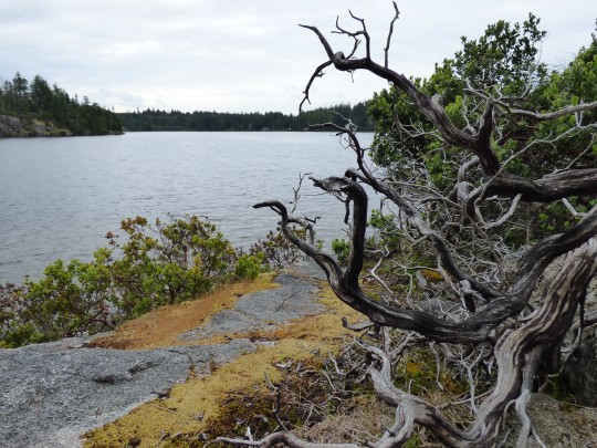
Arctostaphylos columbiana (Ericaceae)
hairy manzanita
in an alternate universe I'm a drag king and my name is Harry Manzanita
Cortes Island | June 15, 2022
#botany#plants#Arctostaphylos#Arctostaphylos columbiana#Ericaceae#Ericales#shrub#hairy manzanita#columbia manzanita#manzanita#BC#flora of BC#photo thursday
20 notes
·
View notes
Text
Shana Cleveland Interview: Changing All The Time

Photo by Kristin Cofer
BY JORDAN MAINZER
When I speak to Shana Cleveland over the phone from Lawrence, MI, I can clearly hear birdsong in the background. It’s fitting, I tell her, given that we’re speaking about her terrific new record Manzanita (Hardly Art), an album deeply embedded in nature. “I’m always outside,” Cleveland says. Yet, listening to the record repeatedly over the past month and then speaking with Cleveland, it’s abundantly clear that nature is more than a character, far from a protagonist. It’s all-encompassing in its complexity, beautiful, harmful, and chaotic.
The La Luz member wrote Manzanita after relocating to rural California with her partner Will Sprott, a multi-instrumentalist who plays on the record. During its writing and recording, Cleveland was pregnant with their first child and ultimately gave birth. Then, at the beginning of 2022, she was diagnosed with and successfully treated for breast cancer. She began to see nature--the very thing she viewed as a balm--as much more random, a fetus living inside her, then a disease, all while she and her loved ones lived among, or within, the outside world. Even small patterns turned her perspectives upside down, watching bugs make their way inside her home in the spring. (“The wasps are crawling in our rooms,” she sings on Manzanita closer “Walking Through Morning Dew” atop appropriately buzzing instrumentation.) Thus, when Cleveland describes being pregnant and giving birth as a psychedelic experience, it’s not anything like a drug trip, but a radical reinvention of her worldview and self-perception.
Manzanita seems like a difficult album to perform, conceptually just as much as instrumentally. Tomorrow night at Old Town School of Folk Music, Cleveland headlines with a full band. (She opens for Destroyer at SPACE in Evanston on Saturday.) Alongside her will be Sprott on synths and keyboard, drummer Geneva Harrison, and Luke Bergman on pedal steel. She’ll rely on Sprott and Bergman to cover the sounds of not only the various instruments used on the record, like dulcimer, glockenspiel, and harpsichord, but for the sonic immersion required to recall the tactility of nature and subsequently captivate an audience. Below, read our conversation, edited for length and clarity, where we talk about Manzanita, Cleveland’s live approach, and her ever-changing relationship with nature.
Since I Left You: Do you know how you’re going to adapt the Manzanita songs to a live set?
Shana Cleveland: I played a show for the record release at Bandcamp in Oakland. I had most of the musicians from the record there: upright bass, drums, pedal steel, synth. [It was] a really cool atmosphere. There’s something about the pedal steel and the synth together: A lot of times, they’re doing really similar parts or even the same part, and it creates a thick eeriness. I expect that will be present in this new lineup as well.
SILY: Do you generally find figuring out how you’re adapting songs live as artistically rewarding as writing and recording them in the first place?
SC: I do. It’s not my strong suit. I’m not great at giving directions. I have this idea in my head, and I never went to music school, and the only way I can describe things is through feelings, emotions, and overly poetic metaphors. It doesn’t work with everybody. I have to work with people that are really good. [laughs] It’s kind of how I try to approach recording, too. The people who are “good” are people who I know really well who get where I’m coming from already and know that I don’t know much theory, and [they] don’t need me to describe things in technical ways to get my point across.
SILY: That you’re giving musicians more abstract guidance, does that often lead to pleasant surprises or unexpected interpretations of what you’re telling them?
SC: It often does. I like that element of surprise. I feel like I’m never gonna be one of these musicians that’s like, “I recorded everything on this album!” That’s the secret ingredient to my music: working with people who are going to add their own spin.

SILY: Manzanita, specifically, has very introspective songs set in specific times or places. How do you approach mentally or emotionally sharing that with a crowd of people?
SC: [Between my solo career] and La Luz, I feel like La Luz is a little less introspective, though those lines are blurring recently with the last La Luz record. I try to be as present as possible. I want to inhabit the same emotional spaces I was in when writing. It feels like cheating the audience if I don’t. It’s more satisfying to me. Sometimes, I’ll tear up when I’m playing. I’m a way more sensitive person now than I was 3-4 years ago. It feels good to be genuine and to get to those places. It’s not hard to get personal and intimate with an audience. For some reason, it feels like the most natural thing to do when performing live.
SILY: A lot of the sounds on the record are referential to or inspired by nature, as is the record in general. How do you approach that aspect live?
SC: I think [that’s] why I wanted to do the full band for every show. The atmosphere of the synths and the pedal steel is key to bringing an element of nature to a live show.
SILY: It seems like your relationship with nature is ever-changing because nature is such a vast, unknown entity. Has that relationship changed further since you wrote and recorded Manzanita?
SC: It’s changed really dramatically. When I wrote this record, I was in the headspace of just having given birth, an initial awakening to seeing myself being part of nature rather than in nature. In between then and now, I had cancer, and that was a huge step further in that direction of realizing, “I’m not in control. I’m changing all the time.” Some things are sort of under your control, but most things for me feel very out of control. I’ve had to come to a place of acceptance of that, which has been very liberating and terrifying.
SILY: You describe being pregnant and giving birth as a psychedelic experience. Do you still feel that way, and is that mindset something you’d use to describe other experiences you’ve had since then?
SC: Yeah. That was what excited me about pregnancy and birth. I’m not one of these girls that played with dolls and dreamed about having a baby myself. A lot of women do grow up seeing themselves as mothers. It wasn’t something I was ever really interested in. I think it’s because of the way motherhood is portrayed in our culture. I saw it as a sacrifice, and of course it is a sacrifice, but it’s [portrayed as] a lot of pastel colors, cute stuff, and sacrifice. What was really exciting for me when I became pregnant was how crazy it was. I felt totally out of control. The world was totally new, which was so exciting to me as an artist. I thought, “Why didn’t anyone tell me about this aspect of motherhood, where everything is so strange, cool, terrifying, and weird?” I really wanted to explore that side with the album.
SILY: I feel like the way you talk about nature is similar, the idea that it’s something we can’t control and has qualities as powerful as a forest fire and as fulfilling as its sheer beauty.
SC: You talk about “going for a walk in nature” as a peaceful, safe way to unwind. I was a poetry major at Columbia College in Chicago and was never interested in nature poetry when I was in school. I thought it was so boring, talking about trees and the wind, even though I loved nature. I never really examined why I wasn’t interested in nature poetry even though I loved being in nature. Certainly, since moving to the country, [I’ve become more interested,] seeing [things like] a rattlesnake kill a lizard before my eyes and then beheading that rattlesnake because I was pregnant and afraid it would come for my baby. Just the harshness of nature, the extreme darkness you’re confronted with in the country is similar to the brutality of birth.
SILY: Has your relationship with this record changed now that it’s out and people are listening to the songs and developing their own relationship with them?
SC: I’ve talked a lot about my feelings about the music. I haven’t gotten the chance to talk to others about it. I’d be totally interested.
SILY: Are you always writing new material, or do you have set times of your life when you write?
SC: I really like to group it all together, to get into a real place of concentration with one album idea. Usually, I kind of work like that. I’ll be writing this one album, concentrating on this one idea, spending a few months in that place. Some things, I do over a longer period of time. I have a record I’m working on that’s just guitar and vocals, and I don’t want to add anything to it, because I feel like the songs are asking for that. I’ve been working on it for a year, and it’s something to come back to when I’m not working on other projects.
SILY: Is there anything else next for you?
SC: We have a La Luz record pretty much done. We’re in the early stages of getting it finished, mastered and everything. It feels pretty fresh and exciting to me right now.
SILY: Anything you’ve been listening to, watching, or reading that’s caught your attention?
SC: Oh my god, I don’t want to talk about what I’ve been watching. I’ve been reading [Vladimir] Nabokov, which I come back to a lot. I pick a novel I’ve never read before, and it takes me a million years. His books are so dense and poetic, I just linger over one sentence for 10 minutes.
I’ve been listening to a lot of Mort Garson and synth music, which was something I wasn’t that interested in before the last couple years. I always come back to Stevie Wonder’s albums from the early 70′s. I was just putting a playlist together of my favorite nature songs, and I thought, “I really want to put some Stevie Wonder on here!” but I looked through my favorite records of his and realized there’s no nature at all. [laughs] I wonder if that’s because he’s blind, that he’s just writing about feelings and conversations, but not so much about nature. Not very visual. Makes sense.
youtube
#interviews#live picks#shana cleveland#hardly art#old town school of folk music#space#manzanita#kristin cofer#la luz#will sprott#destroyer#geneva harrison#luke bergman#columbia college#vladimir nabokov#mort garson#stevie wonder
0 notes
Link
0 notes
Text
Best of 2020
It's hard to say exactly how I felt about 2020. After the disaster that was 2019, my expectations were low. And a wry smile crossed my face when the Seattle Space Needle 2020 New Year fireworks were called-off on account of high winds. An anti-climactic entrance of a new decade. I'd already been watching COVID-19 spreading west from China since Thanksgiving 2019, so I wasn't surprised to become gripped amid a global pandemic and all the steps we undertook to protect ourselves. I found increasingly disappointing the politicization of a worldwide health crisis and the red lines I found myself drawing between those who felt similarly to me and those whose freedom/liberty/etc. was paramount to saving lives. I'm not in a rush to get back to normal. I see 'Normal' as an evolution, not a benchmark, so what will be, will be. I'm approaching 2021 with hope, and I 'hope' that hope doesn't kill me. I faired well in 2020. I kept my job, expanded my data learning, assisted, and instructed courses at the University of Washington. I didn't play or see as many shows or attend baseball games as I would have liked, but I did buy a truckload of vinyl to do my part in supporting the bands and artists who were crippled by the events of the year. Like spending most of my year at home since March, I hope that helped in some small way. So, yeah. My expectations for 2021 are similarly low to where I was a year ago. Maybe we'll be out and about more by the autumn? But I'm not counting on it. I'll keep doing what I can to support my friends, colleagues, students, and community from home. As ever, enjoy the music, and happy New Year.
Favorite Songs of 2020
'Serafina,' Bambara
'Wakin' Up,' Lucinda Williams
'Blinding Lights,' The Weeknd
'You Should Be Sad,' Halsey
'Only The Strong,' Laura Marling
'Wildfires,' Sault
'Grow Your Garden,' Brett Newski
'Lone Wolf,' Armored Saint
'Wait 'til Night,' Empress
'Plans We Made,' Son Lux
'Texas Sun,' Khruangbin w/ Leon Bridges
'Domino,' Nicole Atkins
'Numb,' Elderbrook
'Lead Wings,' Dawn of Solace
'Start Paying',' Lo Tom
'State of the Union,' Public Enemy
'On The Mend,' Man Man
'If You Mean It,' Jonah Mutono
'Hard On Everyone,' Kathleen Edwards
'Darkness Song,' Asaf Avidan
Favorite Albums of 2020
Lucinda Williams, Good Souls Better Angels
Puscifier, Existential Reckoning
Armored Saint, Punching The Sky
Lo Tom, LP 2
Sault, Untitled (Black Is)
Joe Satriani, Shapeshifting
Gillian Welch, Boots No. 2
Spirit Adrift, Enlightened in Eternity
Kvelertak, Splid
Lido Pimienta, Miss Columbia
M. Ward, Migration Stories
The Bug. Dis Fig, In Blue
JARV IS..., Beyond the Pale
Fiona Apple, Fetch The Bolt Cutters
Khruangbin, Mordechai
The Beths, Jump Rope Gazers
Kilo, Maybe We Could
Asaf Avidan, Anagnorisis
The Mavericks, En Español
John Lennon, Gimme Some Truth
Favorite Shows of 2020
Bambara, Sunset Tavern, Seattle, WA 03/03/20
Girls Just Wanna Weekend Ensemble, Hard Rock Hotel, Riviera Maya, Mexico 02/02
Brandi Carlile, Hard Rock Hotel, Riviera Maya, Mexico 01/30
Luscious, Hard Rock Hotel, Riviera Maya, Mexico 01/31
Sheryl Crow, Hard Rock Hotel, Riviera Maya, Mexico 01/31
KT Tunstall, Hard Rock Hotel, Riviera Maya, Mexico 02/01
Patty Griffin, Hard Rock Hotel, Riviera Maya, Mexico 01/30
Amada Shires, Hard Rock Hotel, Riviera Maya, Mexico 02/01
Yola, Hard Rock Hotel, Riviera Maya, Mexico 01/31
Lake Street Dive, Hard Rock Hotel, Riviera Maya, Mexico 02/01
Defining Moments of 2020 (in chronological order)
Quitting smoking (finally – it's almost been a year!)
TA-ing and teaching at the University of Washington
Girls Just Wanna Weekend in Cancun
West Seattle Bridge closure
COVID lock down
Learning new skills working on the house
Birthday in Manzanita
Getting back to a more manageable weight
Realizing I'm better-off gluten-free
New Kittens!
2 notes
·
View notes
Text
Important: Please Read.
Hey guys. I want to give you an update, not for this blog but for what’s going on in my state of California right now.
A good portion of it is on fire. Point blank, its burning. Multiple fires in various neighboring counties that surround mine. Just within the past few hours (from 3:00pm to now) I have watched it progressively get more and more smoky in my neighborhood. Updates have been happening since noon as a new fire has broken out in my town. Below is a brief summary of what’s gone on since then.
(Original Post) 12:57pm - Moccasin, CA had ground crews and a Columbia helicopter battling a vegitation fire along Highway 49 in my county (Tuolumne).
1:30pm - Acreage has jumped and the fire was dubbed the “Moc” Fire.
2:00pm - Moc Fire reached 50 acres with no containment and still moving at a moderate rate.
2:35pm - Air and ground crews have held the Moc Fire at 50 acres but still have no containment. One structure threatened, and road closures have begun. HWY 49 at Highways 120 and 132/Blacks Creek in Coulterville area. Second closure is Kelly Grade/Marshes Flate Road with closures starting at Granite Springs.
2:50pm - Moc Fire is still held at 50 acres, but evacuation warnings have been issued for Marshes Flat Road to Moccasin Ranch Estates, urging residetns to head towards La Grange.
3:40pm - Moc Fire has crossed over Highway 49 and is now at 300 acres heading towards Big Oak Flat and Groveland with a “critical” rate of spread. Mandatory evacuations began from Hwy 120 at Moccasin through Big Oak Flat, to Merrel Rd in Groveland and Priest Coulterville Rd.
4:30pm - Moc Fire jumped to 400 acres. Flames are moving southwest at a critical rate and PG&E has shut power off to 4,100 customers through Big Oak Flat to Merrel Rd. Mandatory evacuations are still in place for Moccasin, Marshes Flat, and Moccasin Ranch Estates. Two evacuation shelters have been set up, one at the Mother Lode Fairgrounds and in Sonora at the Manzanita Building (both places are within my town) and the second being at the Mariposa Fairgounds. Road closures now include HWY 120 from Moccasin to Jacksonville Road. Hard closures for Old and New Priest Grades.
5:20pm - Fire is still at 400 acres and an evacuation warning is issued for Groveland and Pine Mountain Lake residents. Previous mandatory evacuations are still in place as well as the previous road closures.
5:45pm - Moc Fire remains at 400 acres and is now threatening roughly 200 homes in the Big Oak Flat area. The previous evacuation orders and road closures remain in place.
6:15pm - Fire is still at 400 acres and burns on both sides of Highway 49 in Moccasin area of Tuolumne County. New mandatory evacuations have been issued for Jackass Creek Road, Jackass Creek Ridge, and Jackass Ridge Access areas. 200 homes in the Big Oak Flat area still remain threatened.
6:45pm - In addition to the previous evacuations, the Mariposa County Sherrif’s Office has issued and evacuation warning for Highway 49N from the Mariposa/Tuolumne County Line to Mary Harrison Mine Rd.
There has yet to be a new update, but I am listening to my county’s online scanner. I want to share this will you all because I have no idea if or when PG&E may shut power off to my area or widen the areas of evacuations. All I know is I have a mountain separating my home from this fire and it’s progressively getting smokier and smokier in my neighborhood. I have yet to see any ash fall, which is hopefully a good sign. I’m keeping an eye on my surroundings for now, listening to the scanners, and keeping an eye on our county’s local news website for updates.
7 notes
·
View notes
Text
Back from vacation!
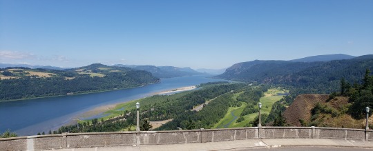
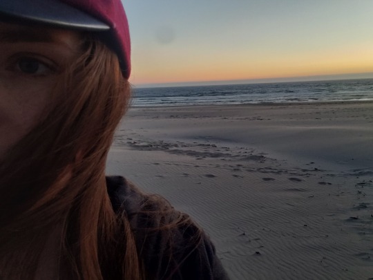
NW Oregon
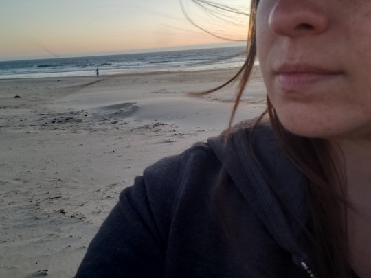
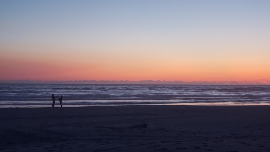
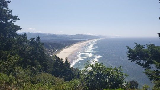
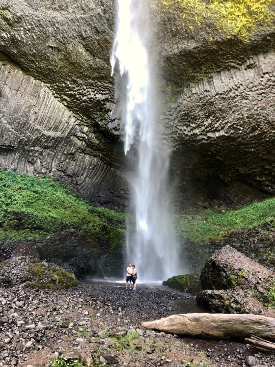
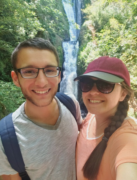
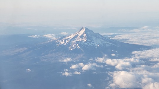
1: View from Vista House (Corbette, Multnomah County) looking into Washington State
2-4: Manzanita Beach at sunset
5: Overlook of Tillamook Coast & Bay
6-7: Latourell Falls & Bridal Veil Falls, Columbia River Gorge, ft. the husband ♡_♡
8: View of Mt. Hood from the plane
13 notes
·
View notes
Text
Spurlos Verschwunden
You know how you read an article online about scientists trying to find a ways to open portals to other worlds/parallel universes/the Upside Down/etc. and you immediately think: haven’t these scientists ever seen any movie or TV show ever made? They know that’s going to end badly, right? Right??
And by that, I mean: Before I Disappear by Danielle Stinson!
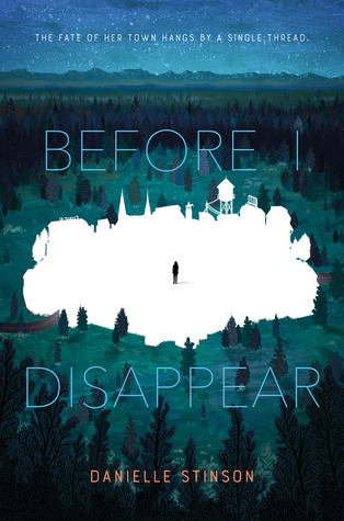
Seventeen-year-old Rose Montgomery, her mom Helen and her little brother Charlie have been living on the run for a long time. Rose and Charlie’s father disappeared when Charlie was still a baby and after that, things fell apart. Helen became depressed, and entered into a relationship with an abusive piece of shit referred to only as the Monster. Rose, Helen and Charlie fled the Monster, but he kept pursuing them farther and farther West. At the beginning of the novel, the Montgomerys are lying low in Nevada when Charlie, who has always been a bit strange, insists that the family move West to Fort Glory, Oregon for reasons Rose doesn’t quite understand. When she sees that the charity Hands for Hearths (a definite Habitat for Humanity expy) has an affiliate office in Fort Glory, she decides to go for it. All Rose wants for her family is a permanent home - someplace better than the ramshackle trailer in which they crossed the country. Hands for Hearths is her best hope.


Fort Glory isn’t just your average town on the Oregon Coast - it’s the site of DARC, the Deep Atomic Research Collider, Oregon’s answer to the Large Hadron Collider in Switzerland. The facility had been shut down, until three weeks ago when it was brought back online...at practically the same moment Charlie started telling Rose that they needed to move to Fort Glory. Spoooooky....
While the Montgomerys adjust to life in Fort Glory, including the influx of tourists, journalists and conspiracy theorists drawn in by DARC, weird things start happening in the town. Crime rises. People randomly go crazy. Rumors are that the DARC is messing with things it shouldn’t be messing with, like poking holes into other dimensions. Because it worked so well on Stranger Things.

Rose just shrugs all this weirdness off - she has bigger problems, like earning a paycheck, helping her family get a house, keeping their ancient truck running and making sure there’s enough food to eat. Charlie, who is clearly some sort of Kid Hero capable of seeing things most other people can’t, tries repeatedly to warn Rose that something bad is about to happen, but, again, she just brushes it off. Rose drives to the nearby town of Maple to the Hands for Hearths office when the whole world goes crazy. The sky turns green, people start attacking each other, even Labrador retrievers turn against their humans! (You know things are truly bad when a Labrador retriever turns against you).

So Rose heads back to Fort Glory as she can as fast only to find that the road literally stops just outside of town. There’s nothing beyond it except old growth forest.
The whole town is gone, along with everyone in it.
Rose, desperate to find her mom and Charlie, runs into the woods. After some shenanigans, she feels this weird tugging...suddenly she’s yanked sideways into a place known as the Fold. The Fold looks like the woods around Fort Glory, but something is wrong. Really, really wrong. Rose quickly teams up with four other teens who have found themselves stuck in the Fold - including the hunky ex-con Ian, whose dark past has made him an outcast in Fort Glory, but as Rose gets to know him, he really doesn’t seem so bad...plus it’s nice to not be alone in the Fold, where the laws of physics don’t apply and your inner demons can physically hurt you. But wormholes and darkness monsters be damned, Rose is going to find Charlie, damn it!
Oh, and her mom. Her, too. It’s not like she forgot her mom was missing, too...

Before I Disappear is a quick, exciting read - it’s also a standalone, which, having read nothing but the first of serieses for a long while, is very refreshing. I love the setting - as a native Oregonian, I am a sucker for stories set in my beloved, bizarre home state. The fictional town of Fort Glory, Oregon seems to be a mix of Fort Clatsop, Fort Stevens and, possibly, Fort Vancouver - you know, all those weird forts they had on the Pacific coast (except Fort Vancouver, which is way down on the Columbia, but the Columbia is how you get down to the coast in a boat so...). All wee little Oregonian children - or, at least, those of us who live west of the Cascades - are forced at some point to go to Fort Clatsop, as it was where Lewis and Clark hung out once they reached the Pacific. I distinctly remember being made to visit Fort Vancouver, too, even though it’s in *shudder* Washington. Fort Glory could also be any of those teeny little coastal towns they have up and down the coast, like Cannon Beach or Seaside or Tillamook or Garibaldi or Nehalem or Manzanita or Netarts or Yachats or Depoe Bay or Newport...ok I should stop because now I’m just naming towns I’ve been to (they’re all very nice. Well, except Newport.The aquarium is cool, but the rest of the town can get sucked into a wormhole for all I care).
Needless to say, I am familiar with the Oregon Coast, it’s where Oregonians go when the sun comes out. (Well, when the sun comes out in the rest of the state. On the coast, the sun only comes out three days a year and it’s always on the days when you aren’t there). So I can speak with some authority when I say the Oregon Coast would be a terrible place to build a fancy underground atomic energy research facility-type thing. I mean, there’s the risk of tsunamis, earthquakes, lingering radiation from the Fukushima Daiichi Power plant Disaster of 2011...
See, this is why we shouldn’t have research facilities dedicated to punching holes into other dimensions situated on the Oregon Coast. Especially not right on top of a town. Put that shit out in the desert where if you poke a hole and let in a Demogorgon or a Darkness Monster, there’s not much around for it to eat. Except desert.
Also, I’m fairly certain any contact with other dimensions will go something like this:


But back to the book: character-wise, the one character we get to know best is Rose, which makes sense as the novel is written from her first-person perspective. Unfortunately, we don’t get to know the side characters as well - Blaine, Becca, and Jeremy aren’t nearly as well-developed. Charlie, aside from being a mysterious child who can see into other dimensions, doesn’t have much of a personality. He’s just an odd kid and Rose absolutely adores him. Rose’s mom falls by the wayside entirely - most of the novel has Rose laser-focused on finding Charlie, while her mom is a bit of an afterthought. But, again, that’s the limitation of the first-person perspective. Aside from Rose, the most developed character is Ian, who apparently has starburst eyes.
Both he and Rose are on the run from their pasts, and being in the Fold is forcing them to confront some pretty harsh truths about themselves and their lives.
My biggest complaint concerning Before I Disappear would be the ending. The story just ends. I would’ve loved a denouement or an epilogue or something where we could see what happens to the characters after the end of the main action...but instead we get action action action action end. So many stories end that way, I wanna know what people get up to when they get home after the adventure, damn it! I’m guessing lots of people, as soon as the adventure is over, just go home, shower, stuff food into their faces and then sleep for the next three straight days. Or maybe go to a hospital. Or immediately get arrested, like in Keanu. Either way, I wish we could’ve gotten more than just “hey it’s over!”
RECOMMENDED FOR: Anyone just fresh off a binge of season 3 of Stranger Things and are desperate for another cool inter-dimensional teen drama involving mysterious research facilities, wormholes and disappearing towns. Also fans of YA genre stories and Oregonians.
NOT RECOMMENDED FOR: non-YA fans, anyone currently living on the Oregon Coast, scientists currently working at the Large Hadron Collider in Switzerland.
RATING: 3.99/5 (0.1 point removed for the abrupt ending. I wanted more! *cries*)
RELEASE DATE: July 23, 2019 (Ha! I got this review done on time!!)
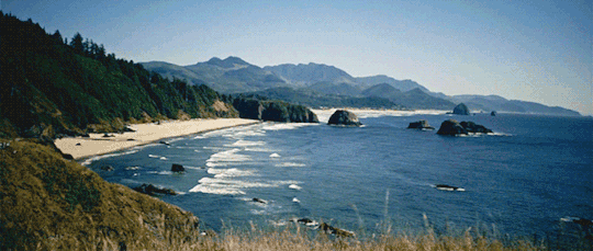
THE GORGEOUS OREGON COAST:
FOR ANYONE CONFUSED ABOUT THE TITLE OF THIS REVIEW: Learn some German.
#before i disappear#danielle stinson#ya#book review#ya science fiction#ya sci fi#parallel world#the upside down#string theory#young adult science fiction#parallel universe#wormhole#ya fantasy#oregon coast#books set in oregon#oregon in fiction#oregon
3 notes
·
View notes
Text
Looking for a Gold-Rush Town Named Chinese Camp
Looking for a Gold-Rush Town Named Chinese Camp
Four aging horses dragged us through the manzanita and boulders, the stagecoach swerving dangerously with each bump and wiggle. The children shrieked with excitement as we threaded our way through Columbia State Historic Park, a mining camp from the days of the Gold Rush about a two-and-a-half-hour drive from Oakland, Calif.
Suddenly, a bearded white man in a red bandanna jumped out from the…
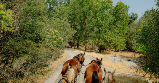
View On WordPress
0 notes
Photo
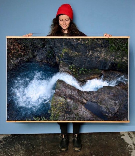
Just in - New 48x36” Print of this Lava Canyon waterfall shot from the cliff above (not a drone!) - You know how much I LOVE heights! . Get in touch if you’re interested in hanging this piece on you wall. Local Portland pickup or global shipping available. You can also scoop it up at the Etsy Shop - Link in bio - or visit ArtPrintsWallDecor.etsy.com . I have a few other biggie poster style prints in stock right now; Manzanita Sunset, Columbia River Gorge 120mm and more- DM for photos. . You can also find a few of my Joshua Tree and desert poster prints at @citrine.bloom & @pinkypdx in Portland - sold with or without rails. . 👉🏽👉🏿👉🏼 #nmarkprints 👈🏽👈🏿👈🏾 (at Mt Saint Helens Lava Canyon) https://www.instagram.com/p/B6lmH4cHOod/?igshid=176yrlnqjxxj5
0 notes
Text
Oregon hunting preview 2019: Bear, Cougar And Upland Birds
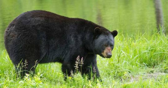
Bear hunting is best in the Coast Mountains (better closer to the coast) and west slopes of the Cascades, including dense forests of the Santiam unit.
Bear numbers decrease immediately east of the Cascade crest and through the Ochocos, but remain high and huntable in northeast Oregon.
There are no shortages in cougars across most of eastern Oregon, especially near deer winter ranges.
It’s illegal to bait bears, but not to hunt near their favorite foods — berries of all kinds, orchards, even manzanita berries and oak acorns (especially in southern Oregon).
Target both bears and cougars with predator calls matching prey species.
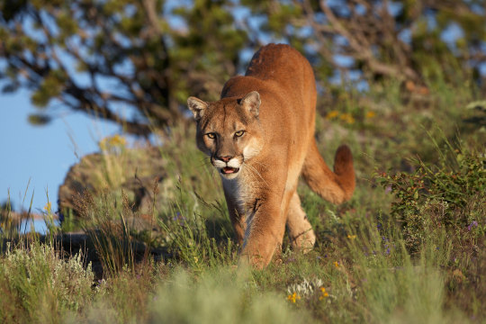
Cougar hunters, however, should hunt with partners to avoid nasty surprises from behind, and remember to be more patient with cougars than with coyotes.
Another good cougar tactic for late hunting is tracking them through the snow.
Pheasants: After a nice peak last season, pheasants took a bit of a hit in the late, wet spring across some of their best habitats in eastern Oregon.
Numbers are down the most in Umatilla, Union, Morrow, Wheeler, Gilliam, Wasco and Sherman counties.
Brood production was highest in the Heppner, Malheur and Umatilla districts.
In Malheur County, pheasant counts were nearly 40 percent below last year's, although hens still averaged four chicks per brood.
Biologists no longer bother to discuss pheasant outlooks in western Oregon, other than to mention highly popular put-and-take hunting at state-managed wildlife areas — Sauvie Island, E.E. Wilson, Fern Ridge and Denman.
Chukar: Malheur County had a whopping 11-chicks-per-brood production and hunting should be good.
Fair to good hunting is also predicted for Hells Canyon.

Production fell, however, across the northern tier of counties bordering the Columbia, although hunting will still be decent in both the Deschutes and John Day river canyonlands.
Quail: California quail did well across much of southeast Oregon, from Lake County north to Malheur and beyond. Look for up to 10-chick broods around brush and cover, especially close to water and agricultural areas.
Summer Lake managers report a good number of birds in brushy areas around the management area's old homesteads.
Quail also nested well in southern Oregon.
Grouse: Grouse numbers improved this spring, both across much of northeast Oregon and, especially, in the mountains and forests of both the Cascade and Coast mountain ranges.
#cougarhunt#cougarhunter#cougarhunting#bearhunt#bearhunting#bearhunter#uplandbirds#uplandbirdhunting#uplandbirdhunter#hunter#hunt#hunter x hunter#heart hunter#huntlife#huntlove#huntness#huntworld#hunting#huntinglife#huntinglove#huntingseason#season#preview#oregon#oregonhunting#oregonhunter#oregonhunters#2019preview#update#overview
0 notes
Photo
Hi Michael,
My son Matt and I (age 35 and 65) will be hiking the Grand Canyon rim-to-rim-to-rim (r2r2r) in May as a continuous ultra-hike. This will be the farthest we’ve ever hiked in a day (42 to 47 miles, depending on the route), and we’re excited. Since you have done this hike in a day, we’d appreciate your advice. Do you plan your rest periods? What about pace? On a recent 30-mile hike with rolling hills in Maryland, we averaged about 3.3 miles per hour. Should we expect a slower pace on the r2r2r? What else do we need to know?
We have hiked in the Grand Canyon probably a half-dozen times and have done rim-to-rim (r2r) three times during the last 10 years or so. We are familiar with the potential temperature variations and know to plan carefully around calorie intake, hydration, and electrolyte replacement.
Although they’re not desert environments, we have dayhiked eight or so 14ers in Colorado, plus done hikes in northern New Mexico (Wheeler Peak), the Tetons in Wyoming, and extensively in Glacier National Park. Most of these dayhikes have been in the eight- to 20-mile range, with early-morning starts by headlamp.
In prepping for r2r2r, Matt and I put in three- to four-hour hikes every Saturday (12 to 15 miles) with weighted packs (up to 45 pounds), plus consistent cardio, core, and weight work throughout the week. Over the last three or four months, we have done two local 20-milers and a nearly 30-miler over rolling terrain. We’ll do another 30-miler about a month before our Grand Canyon date.
As to what we’ll carry, our overall intention is to go as light as we possibly can. On the Grand Canyon corridor trails, there is water every seven miles or so—Phantom Ranch, Cottonwood Canyon, North Rim, and a few places on the Bright Angel Trail. We’ll carry enough water to get us from one source to the next, plus enough for contingencies. We intend to use Hammer Nutrition’s product called Perpetuem for most of our calories, so we’ll carry powder to mix with water along the way. We likely will carry a bar or two plus a few gels as well. Beyond that, we’ll each probably bring a light windbreaker and a long-sleeve shirt.
I’ll also throw in a multi-tool and carry a satellite locator with GEOS capability—just in case.
That’s it! Any thoughts you have are welcome and appreciated.
Best,
George
Columbia, MD
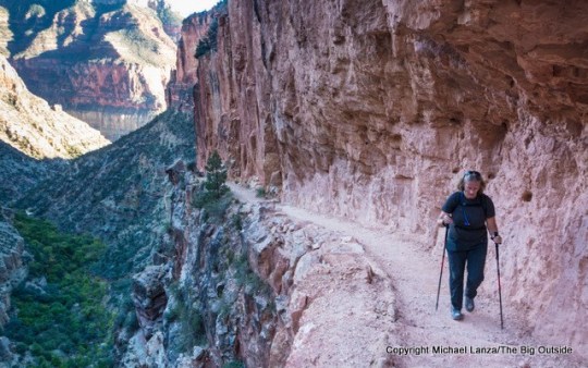
My wife, Penny, hiking the North Kaibab Trail in the Grand Canyon.
Hi George,
Yes, I have hiked the Grand Canyon rim-to-rim-to-rim in one day and over two days, and I have plans to return next fall to attempt to run rim-to-rim-to-rim (r2r2r)—42 miles and over 21,000 vertical feet—in one day.
My downloadable e-guide “Hiking the Grand Canyon Rim to Rim in a Day” offers expert tips specific to the unique challenges of successfully and safely hiking or trail running rim to rim in a day, including preparing for it, the ideal seasonal windows, tips on strategy and direction to hike, gear, and all possible hiking itineraries combining the North Kaibab, South Kaibab, and Bright Angel trails.
It’s good that you’re already familiar with the Grand Canyon environment and the trails you’ll hike doing the rim to rim to rim (the North Kaibab and either the South Kaibab or the Bright Angel), and it sounds like you’re training seriously. I’ll focus on your questions and point out what I believe are key issues and strategies to think about.
Hi, I’m Michael Lanza, creator of The Big Outside, which has made several top outdoors blog lists. Click here to sign up for my FREE email newsletter. Subscribe now to get full access to all of my blog’s stories. Click here to learn how I can help you plan your next trip. Please follow my adventures on Facebook, Twitter, Instagram, and Youtube.
But you can also see my training tips in my stories “Training For a Big Hike or Mountain Climb” and “Cranking Out Big Days: How to Ramp Up Your Hikes and Trail Runs,” as well as my feature stories “Fit to be Tired: Hiking the Grand Canyon Rim to Rim in a Day” and “April Fools: Dayhiking the Grand Canyon Rim to Rim to Rim” about my r2r2r, which both provide some info on how to plan this hike, but not nearly as much detail as my e-guide to hiking rim to rim.
Regarding pace and managing your time, my ultra-hiking friends and I often try to cover eight to nine miles every three hours, and the longer the hike—meaning anything over about 20 miles—the more diligent we are about managing our pace and staying on schedule. We take a roughly 20-minute break every three hours to cool off, eat, refill/treat water, bathroom stop, and take care of our feet (remove shoes and socks to cool and dry them; taping and blister treatment if needed).
Click here now for my expert e-guide to hiking the Grand Canyon rim to rim!
Hiking the South Kaibab Trail, Grand Canyon.
Even at that rate, those stops add up to significant time over the course of a huge hike like the r2r2r, so you have to keep track of time and be efficient. By later in the day, it’s easy to lose track of time and not force yourself to get up and move soon enough; and of course, by later in the day, muscles may be starting to stiffen up, and stopping too long can exacerbate that. There’s just two of you, so fewer people to have a slowing effect on the group. Still, you don’t have to both stop just because one person has to pee.
Retaping feet at the North Rim, mid-r2r2r.
As for feet, I tape pre-emptively to help prevent blisters on ultra-hikes—even though I almost never actually get blisters on hikes of moderate distances. You’re going to take something on the order of 110,000 steps that day—that’s a whole lot of cumulative friction. I put two or three overlapping strips of athletic tape around my heels. If my toes develop hot spots, I’ll tape them immediately, before they develop blisters. We carry tape and often reapply it multiple times during the day; but athletic tape stays in place pretty well even when feet get sweaty.
I always wear highly breathable but reasonably supportive, lightweight, low-cut hiking shoes or trail runners. In the Grand Canyon, you don’t need waterproof shoes, you need shoes with mesh uppers and no membrane so they’re very breathable. See my reviews of some favorite lightweight hiking shoes, including the La Sportiva TX3, Scarpa Epic Lite, and Brooks Cascadia 12.
Use trekking poles, they’re critical on such a huge day. See my reviews of trekking poles. I’d recommended an ultralight model like the BD Distance Carbon Z or the Ultimate Direction FK Trekking Pole (which I’m field testing now and plan to review).
Get the right daypack for hikes like the Grand Canyon. See my “Gear Review: The 7 Best Hiking Daypacks.”
Assuming it’ll be as hot as it can be at that time of year, think about the r2r2r in terms of where you’ll be at the hottest hours of the day—or when you’ll encounter the heat based on where you’ll be at various times of day. We started in the dark (around 5:30am) on the South Kaibab Trail, the most direct route to the bottom and truly an absolutely beautiful trail to descend when the sun’s rising, because you’re constantly looking out over the canyon.
My wife, Penny, hiking the upper South Kaibab Trail, Grand Canyon.
Even taking time for some photos, we reached the river in under 2.5 hours, partly because the trail is so good. Get some memorable photos, but get down to the bottom early and start ascending the other side before the heat starts building. We did the r2r2r on April 2, a time of year when we the initial few miles of the North Kaibab Trail—beneath the sheer, close walls of the canyon’s Inner Gorge—remain shaded and cool. In May, with the sun higher in the sky, you could get direct sunlight earlier in the Inner Gorge, and that will raise temps very quickly in there. Fortunately, you’re beside the creek and it’s gorgeous hiking.
In all likelihood, the hottest part of your entire day will be when you emerge from the Inner Gorge into the wide-open middle miles of Bright Angel Canyon—before and beyond Cottonwood camp. You’ll get there around mid- to late morning, as the temperature’s rising quickly, and have several miles of hot sun with little shade. Once you turn the corner into Roaring Springs Canyon on the North Kaibab Trail (at the Manzanita Rest Area), you’ll get shade again at some point because the trail hugs the cliff on the southwest wall of that canyon. The upper North Kaibab Trail reaches forest and cooler elevations. By the time you’re back down in that open middle section of Bright Angel Canyon, it will be hours later, probably evening—although in May it certainly could still be hot.
Plan clothing using the same way of thinking that I outlined above. In early April, we started and finished the r2r2r in strong, cold winds in early morning and later evening. But on that 17-hour day, I was only cold the first half-hour (or less) at the outset, hiking downhill in the dark in that wind. We were plenty warm enough hiking back up the South Kaibab in the dark with essentially the same wind and temps, wearing just a T-shirt, long-sleeve layer, and wind shell. If I had carried any more clothing than that, I would literally have just carried it most of the day after the first half-hour.
Want more? See “The 20 Best National Park Dayhikes” and “Extreme Hiking: America’s Best Hard Dayhikes.”
David Ports hiking the lower North Kaibab Trail.
Unless the forecast is for unusually chilly temps, I’d only bring the minimal layers described above (probably also a warm hat and light gloves), in addition to a wide-brim sun hat. If you stop to rest in the lower canyon, it will likely be warm, even at night. See my review of the best ultralight hiking jackets and my “Review: The Best Base Layers for Hiking, Running, and Training.”
Carry a 3-oz. emergency bivy sack, just in case you’re forced to stop. We figured that our likely worst-case scenario was that one or more of us would just feel too wrecked to continue, find a place to crash on the ground for a few hours, not expecting much sleep, but enough to eventually get up and continue. That obviously presumes a high degree of experience in this environment, and self-sufficiency, to avoid a serious accident or emergency.
I think your water plan is smart. At a strong pace, you’ll reach water sources in intervals of three hours or less, so you likely don’t need to carry more than two liters at any time. Check with the backcountry office about water sources right before your hike. I always drink a lot at water sources, to fully hydrate myself before I start walking, reducing the amount of water I need to carry.
But I’ll tell you about one interesting situation we encountered on our r2r2r: It’s possible to get a case of hyponatremia, where your body takes in more water than it can absorb. (Basically, it happens when your body lacks enough sodium/electrolytes to bond with water molecules, so you end up just urinating the water out rather than your body putting it to use.) One of my friends on our r2r2r peed about 45 times—yes, he counted—about once per mile. He didn’t have any bad side effects, but keep in mind the possibility of actually over-drinking and not consuming enough sodium/electrolytes, especially in cool temperatures.
Do this trip smartly and safely. Get my expert e-guide to dayhiking the Grand Canyon rim to rim
or my expert e-guide to backpacking the Grand Canyon rim to rim.
David Ports hiking up the Bright Angel Trail, Grand Canyon.
Regarding your nutrition plan: I haven’t used Perpetuem. If it works for you, great. I’ll just say that my experience on really long hikes is that, especially in heat, my stomach and G.I. system can get a little upset (as happened to me on an attempted 50-mile dayhike across Zion). You’re just really overtaxing your body. I also find that I have a tolerance ceiling for sweet foods (like chocolate), or energy bars, and some other foods.
A man needs about 250 calories per hour in endurance events. Experiment with the sorts of foods you like eating on the trail, but I like to include a diverse blend of sweet and salty—the latter particularly important to replace sodium your body’s losing. I carry foods like nuts, sandwiches, dried fruit, candy, and I plan on eating upwards of 4,000 calories. Real food is heavier than powder, granted, but some variety may enable you to actually stomach what you need to consume, especially in the last hours of the day, when you’re most depleted and may find your appetite depressed if you don’t feel great. I also keep snacks within reach while hiking, so that I’m regularly ingesting calories in small amounts. (I like dried mangoes, which are high in calories per ounce.)
Check out my “Gear Review: The 7 Best Hiking Daypacks,” as well as my “8 Pro Tips For Avoiding Blisters,” including the really helpful reader comments at the bottom of that story, and my “10 Tricks For Making Hiking and Backpacking Easier.” And see all of my stories about the Grand Canyon by scrolling down to Grand Canyon on my All National Parks Trips page.
Good luck. I’d love to hear how it goes for you.
Best,
Michael
Tell me what you think.
I spent a lot of time writing this story, so if you enjoyed it, please consider giving it a share using one of the buttons below, and leave a comment or question at the bottom of this story. I’d really appreciate it.
Hi Michael,
My son Matt and I completed our r2r2r hike. We started at 3:35 p.m. on Thursday (5/19) down the South Kaibab Trail (beautiful and steep). We got to the North Rim at about 1:15 a.m. and finished on Friday coming up the Bright Angel trail at about 12:30 p.m.
It was a long day and a heck of a lot of hiking. We had great weather throughout. (It was only about 90 degrees at Phantom Ranch.) The toughest part for me was the last 4.5 miles from Indian Garden up the Bright Angel Trail to the South Rim.
A big lesson for me is that no matter how hard you train, age makes a difference and one has to take that into account. (I’m 65 and my son is 35.)
Click here now for my expert e-guide to hiking the Grand Canyon rim to rim!
In the end, other than fatigue, we handled the hike well.
Just as an FYI, Hammer Nutrition has a bunch of products for calories, supplements and electrolytes specifically for endurance activities—including detailed usage guidance. My sons and I have found their stuff to be excellent.
We both appreciated your thoughtful advice. Best of luck with your outdoor blog. It’s quite good.
Thanks again,
George
I can help you plan the best backpacking, hiking, or family adventure of your life.
Got questions about hiking, backpacking, planning a family adventure, or any trip I’ve written about at The Big Outside? Email me at [email protected]. I’ll answer your questions to help ensure your trip is a success. See my Ask Me page for details.
—Michael Lanza
You live for the outdoors. The Big Outside helps you get out there. Subscribe now and a get free e-guide!
0 notes
Text
Ecuador follow up questions
Churches
La Merced - cursed tower
Cathedral - missed it, Last Supper and near plaza grande
Basilica - iguana instead of gargoyle, can climb
Panecillo
Made of aluminum
1970s created
Used to be a temple in ancient times for worshiping sun
Little piece of bread translation
Stepping on snake is common iconology
Is only virgen with wings
Fruit names
Maracuya - passion fruit
Guanábana - soursop
Cherimoya - custard apple, what was had at the Mercado
Animals / nature
Angelfish
Moorish idol = black and white and big character in finding nemo
Small fish in Bache = concentric pufferfish
Rainbow fish = blue-chin parrotfish
Cactus = opuntia
Mini apples poisonous = manzanita
Cherry blossom = arupa tree
Things I wish I saw and did
Botanic garden
Teleférico
Vista Hermosa
Main sites in book
Biked Quito
Visited cathedral
Amazon rainforest!!
Mitad del Mundo!!
Craters and volcanos!!
Dragons
Not iguanas
Individually evolved
May be due to dinosaur bones and not knowing
May be human brain thinks of predators
Galapagos and Ecuador fun facts
4 million years old so young
Evolved species from land, all immigrants
Underwater island a bit further out
Tomas de Berlunga discovered it
$6000 GDP per capita, 16 M people, $9.8 B GDP
$400 M from tourism in Galapagos per year
30k people on islands, 20k in Santa Cruz
Volanoes like volcano wolf on Isabela, younger island
Pinta turtles and lonely George - longer necks, died
How global warming and new species in island is ruining everything
Ecuadorian history
Pre Inca were indigenous folks
1500s Incas Atahualpa defeating brother for throne
Incas mainly Ecuador and Peru
Late 1500s Pizarro defeating Atahualpa (post Columbia, 1492)
Fun fact check: Panama hat for point of sale but origin is Ecuador
1 note
·
View note
Text
Portland is about 70 miles from the Pacific Ocean, at least “as the crow flies”. Close enough that we all know its there,* but still just far enough away that it’s not the easiest place to get to regularly. By car it’s a 90-120 minute drive. By bus, maybe three hours. By bike? At bare minimum, one long day of a ride.
And anyone who lives in Portland and bike tours hears the clarion call of the waves at least once a year. So plans to “go to the Coast”** are made. Now, one can take a couple different buses with bike in tow to get out there, but there’s that itch that can’t be scratched, called “biking to the coast”.
As I said, at bare minimum it will take you the better part of a day to get out there, and if you want to take it easy, two. The big problem is there is no great route to the coast. The most direct ways are the most busy, so to avoid them, you’re either doing something circuitous, or hard, or both. Some people go for the Advanced Studies of figuring out an all-gravel route over the Coast Range using the tangle of unmarked logging roads criss-crossing the slopes. While rewarding in its own badassitude (and solitude), it’s not for the faint of heart or those without good GPS units.
The weekend of May 20 was turning out pretty nice in Portland, which was really nice after such a damn long winter. Several days in a row without rain? Sign me up! Originally I was going to have a “three day weekend” starting Sunday the 21st, but at the eleventh hour it remarkably turned into a four-day one starting Saturday! Pack the bags, it’s time for a mini-tour!
With four days to play with, I had the time to take a two day ride out to the coast, and even ride back if I wanted to. There were many different options, but I decided to go with this one: Ride from my house over the St Johns Bridge and north on US 30 to Scappoose, then take the Crown Zellerbach Trail over the Nehalem Divide, then follow the Nehalem out to the ocean at Nehalem Bay. I’ve only done the Crown Zellerbach once before in 2014, so I was ready for another expedition. I had never been down the Nehalem all the way, though I almost did in 2013.
I got a late start on Saturday, pretty typical. The ride through North Portland and over St Johns Bridge was pretty smooth for a weekend day. US 30 was okay for a bit, but Dirty Thirty lived up to its name, as a piece of metal pierced my rear tire outside of Scappoose. Ugh. Yeah, I don’t know if I’m feeling the supple tire action for these conditions. I replaced the tube with my spare and soldiered on.
The Crown Zellerbach Trail was tougher than I thought it would be! It’s an old logging railroad, mostly unpaved, and used for years as a logging truck road. I had to get my loaded bike over a downed tree in the first couple miles and worried that this would be a regular occurrence. Thankfully that was the only one, at least on the section of trail I completed. The rest of the trail alternated between peaceful and sublime moments interspersed with steep climbs and mud. I reached the top of the Nehalem Divide, saw the “trail closed ahead” sign (most likely because of logging activity, but I heard afterwards there’s more downed trees on this section), and decided to descend on the paved Scappoose-Vernonia Hwy instead.
I ended the night at Anderson Park in Vernonia, almost fifty miles in.*** The nice thing about this park is it’s right on the edge of this small town, so all those conveniences are readily available. I ate dinner at a nice Mediterranean place, and in the morning had breakfast at the cafe. And…there was another bike tourist at the campground! Robyn was heading from Portland out to the coast, but instead of going to Nehalam, she was planning a 90 mile day using the Westport Ferry across the Columbia and then eventually to Astoria! It was tempting to join her, but I didnt’ feel like a 90 mile day**** and really wanted to check out the Nehalem. (But man, I do need to get to Astoria at some point!)
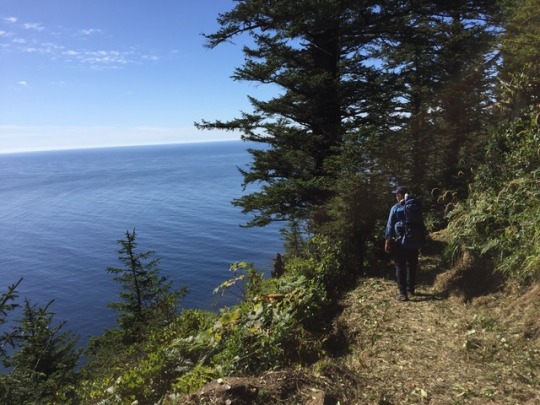
The road ahead was mostly peaceful, as I was following a river down to the sea. The route (OR 47 to 202 to 103) was mostly quiet too, though there was a vehicle at least every couple minutes. The “store”***** at Birkenfeld was open, which was surprising, as it’s often closed. I had a nice cold lager, which was so refreshing at that point. I took a break at the store in Elsie (junction of 103 and US 26), then grit my teeth for a couple miles of 26 until the turnoff for the fabled Lower Nehalem River Road.
This road is a secret back door to the coast, not well known and lightly trafficked. It was closed for a few years due to a washed out bridge, but another reason why it’s off the beaten path is because about 20 miles of it is gravel. The first five miles from 26 were paved, and brought me to Spruce Run Campground. The campground was pretty nice and besides the Nehalem. I was already 50 miles in and considered staying, but fuck it! I really wanted to see the ocean tonight! So I pressed on. Also, since I haven’t ridden a real long distance for a real long time, I wanted to push myself and see if I was still capable for the long haul.
The first section of the gravel was actually pretty nice and level, which lulled me into complacency. However, when I crossed into Tillamook County by the Salmonberry River crossing, things changed. The gravel got chunkier, and there were several small but very steep hills that sapped my energy. Plus, I saw signs for a road closure at Wolf Creek. Am I on Wolf Creek Road? I don’t think so, but nothing is well signed here and damn, I haven’t seen a car coming in quite some time. So then I started to panic, and push on harder. A road closure would mean the promise of the coast would be denied, and I would have to turn around and come back the way I came.****** I was not in a good mental state. Eventually, a car approached from the opposite direction and I flagged it down to ask the question. Yep, the road goes through to the coast! My mood was lifted for a bit…until I noticed my front end getting squishy. Damn. Slow leak? I hate them, since sometimes you can’t find the leak. And I had no spare tube. (I typically repair the damaged tube at camp, but I had forgotten that the tube I pulled out the rear had sealant in it. No go.) Plus, getting the tire on and off the rear was a total pain. Would the front be the same?
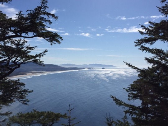
I put some air into the front. It seemed to hold, so I pushed on. Thankfully, the pavement began back up, so I didn’t have to worry about another rock causing a pinch flat or something. I rolled into the town of Nehalem around 7 pm, and found myself at a pizza place where I devoured a small pie. Then I rode the couple miles to Nehalem Bay State Park and dumped bike and gear at the hiker/biker campsite. I ran over to the beach, where I just missed the sunset. But it was still great to see the Pacific Ocean in all its glory!
There were people camped in the hiker/biker campsite, but no one was present or awake, which gave the place an eerie presence in the twilight as I set up camp. Exhausted after an 80 mile day, I slept good that night.
I awoke Monday morning, May 22, with no real plans. I knew I wasn’t going to ride all the way back to Portland, so I just needed to be in Tillamook by 1 PM on Tuesday to get home on time. I could stay here at Nehalem Bay for another night, but I decided I wanted to explore. First things first: fix the front flat. Thankfully, the front tire was easier to remove and mount, and the leak was obvious. I patched it and I was good to go.
First I biked the couple miles into nearby Manzanita, a cute li’l beach town, where I got some supplies and got an underwhelming lunch. (My preferred option was closed.) I rode south along US 101 for about 20 miles to get to my destination for the night, Barview Jetty. Oh sure, I could have ridden another 25 miles to my favorite campsite on the coast, Cape Lookout. But I felt like taking it easy, and I had never been to Barview. Barview was a real nice campground, but expensive! I’m used to the state park hiker/biker sites costing $5 to $6 a night. But Barview is a Tillamook County park, and the site was $20! Yeeps! Still, I was really close to the beach, and I had a good sunset.
Tuesday morning I packed up camp, rode about 13 miles south on 101 to Tillamook and caught the bus home. My coast mini-tour was done.
All in all, it was a decent trip. But the ride to the coast was longer and tougher than I planned, at just about 130 miles. Since I hadn’t ridden anything that long in a long time, it felt harder. But it was nice to know that I could push myself to do this, especially with some good touring plans on the horizon. As it was, this was the first time I had camped two or more consecutive nights since my Vancouver Island-San Juans Tour in September/October. I had only done two consecutive nights then, so this trip was a good test of my touring setup and my ability to get a decent nights’ sleep on the road. And I did, at least after the first night. This shakedown gave me the confidence to go out on a longer tour soon.
And man oh man, I love the coast! It’s been too long, Pacific Ocean. At certain points in my life I was quite the “beach rat” and got to know some beaches on the Atlantic coast. The Pacific is more awesome in many ways, except for the fact I can’t swim in it. And I realize that I need to get out to the coast more often. Will I bike out the next time? Probably not. I’ll load my bike onto one of the buses to bring me most of the way, but the ride to the coast makes me realize how much I just want to be on the coast. The way out is nice at times, but there’s nothing spectacular, few points of interest. And there’s no perfect way. Yet.
They are working on the Salmonberry Corridor Trail, a path that would follow the abandoned Port of Tillamook Bay Railroad from Banks to Nehalem. This would mean a car-free way to the coast on a gentle rail grade. I’m really looking forward to its completion, though it’s going to take a few years. In the meantime, Washington State has the Willapa Hills Trail, and I need to get back there at some point. I can dream…
*Which is good for people like me who have never lived more than 70 miles from any ocean.
**If you say you’re “going to the shore” or “going to the beach”, everyone will know you’re from out of town.
***It would have been easier and more logical to end at Big Eddy Park, as going to Vernonia requires back-tracking. But Big Eddy was closed so I had to go with what was available. I passed by Scaponia Park on the way in, which I thought was closed, but it looked like it might be open.
****Of course, I ended up doing 80 miles as it was…
*****When I first visited it in 2001, it truly was a country store. Now it is basically a roadhouse/bar/music venue.
******Yeah, I could turn onto 26, but that road is too busy and narrow, and features some serious climbs.
A tour to the coast: May 20-23 2017 Portland is about 70 miles from the Pacific Ocean, at least "as the crow flies". Close enough that we all know its there,* but still just far enough away that it's not the easiest place to get to regularly.
#barview jetty county park#crown zellerbach trail#nehalem bay state park#nehalem river#Oregon Coast#pacific ocean
3 notes
·
View notes
Text
Winter hidey-holes of the Salish Sea | Portland Island
With winter now firmly upon us, two things are bound to happen in the coming months in the Salish Sea: low pressure systems will sweep in off the Pacific Ocean bringing strong southerlies, and brisk northerlies will push down from the Fraser River Valley.
As boaters, we obviously need to keep a keen eye out for these potentially hazardous winds and to protect our boats appropriately. And if you’re out cruising this time of year — which we highly recommend — you’ll want to have some places in mind to duck in and wait out weather from any direction.
In our years spent cruising Puget Sound and the San Juan and Gulf islands throughout the short, cooler days, we always had a lot of anchorages or docks in mind to escape and hide in the event of a big blow. That being the case, I’ll share a few of those over the next few weeks and months for those out taking advantage of the amazing winter cruising in the Pacific Northwest. Our first was Blind Bay. The second was Manzanita Bay. Here’s the third:
Royal Cove, Portland Island
British Columbia’s Gulf Islands are our favorite place to cruise during the winter in the Salish Sea. There are a number of wonderful parks, anchorages, towns and cities to visit, and there is quite a bit of protection from the southerlies and southwesterlies that briskly sweep through. And of all our comfortable winter hidey-holes in the Gulfs, Portland Island’s Royal Cove is among the best when an ominous southerly is in the forecast.
Portland Island sits north of Sidney and just south of Salt Spring Island.
Located on the norther tip of Portland Island and protected from the northwest by Chad Island, Royal Cove has a straightforward entrance from the north and plenty of depth in the middle. The park dinghy dock at the south end of the cove is there all winter and will put your feet onto miles of excellent hiking trails that encircle the island. A few things to note, though, are the rocks and reef to the west, shallow depths in the southeast corner of the cove and a bottom composition that can include copious amounts of kelp. Besides that, you’ll find numerous places to take a stern line to shore, which is a tactic that we highly recommend if there are other boats in this small-ish anchorage (there rarely are in the winter) or if a big southerly is coming. And this is one of the reasons we love it as hidey-hole and have used as such on so many occasions.
A rough look at where to drop the hook and then stern tie. Always be courteous and conscious of other boaters needing to stern tie as well.
Yahtzee stern-tied in Royal Cove on a not so windy day.
We’ve sat comfortably through storms that have thrown gusts in upwards of 50 knots over the island and our anchoring tactic goes like this: Drop the hook in the middle of the cove to the north and west of the park dock. Then back down towards the rocks to the west of the dock. MAKE 100% SURE the anchor is set and holding and then find a ring mounted in the rock to take a shoretie to and then back to the boat. If’ it’s really blowing a hooley and if there are no other boats in need of it, you can tie two lines to shore for extra security. We’ve done this, and slept very well. When tucked in like this, the wind streams right over the trees that are high above and behind you. It’s simply perfect, and the only movement of the boat can be that of a ferry wake from nearby Satellite Channel.
Read More Here ….
hideyholesIslandLiving AboardPortlandSalishSeaWinter
The post Winter hidey-holes of the Salish Sea | Portland Island appeared first on YachtAweigh.
source http://yachtaweigh.com/winter-hidey-holes-of-the-salish-sea-portland-island/
from http://yatchaweigh.blogspot.com/2018/01/winter-hidey-holes-of-salish-sea.html
0 notes
Photo


Olimme lähdössä aavikolle itään, mutta välissä on vuoret ja luonto yllätti lumimyräkällä. Vaikka meillä on snow&mud renkaat, niillä ei ole asiaa kiemuraisille teille, jonne vaaditaan joko ketjut tai paremmat talvirenkaat. Olimme suunnitelleet suuntaavalla myöskin pohjoiseen, mutta pääsy Columbia-joen laakson maisemareitille ja vesiputouksille pysyy suljettuna niin kauan kunnes paha metsäpalo saadaan hallintaan (arviolta vasta marras-joulukuussa). Niinpä suuntasimme länteen rannalle. Aina yhtä sykähdyttävä, kaunis, ihana Oregonin ranta; Lokakuun puolivälissä hetkittäin auringon lämmittäessä on kuuma kuin keskikesällä. Ikoniset maamerkit kuten Haystack Rock Cannon Beachilla hämmästyttävät. Toisaalta ilahduttavat pienet (surffaajien löytämät) hiljaisemmat rannat, jotka löytyvät havupuiden reunustamien polkujen päästä, tai hikisen vaellusreitin päässä häämöttävä huikea näköalapaikka. Tähän maisemaan ei voi olla rakastumatta. Northern Oregon Coast. Pohjoinen Oregonin ranta. Cape Kiwanda - Cape Lookout - Cape Meares - Manzanita - Cannon Beach
0 notes
Text
The Place, the Region, and the Commons: Gary Snyder’s The Practice of the Wild
“When you find your place where you are, practice occurs.” - Dogen
The heart of a place is the home, and the heart of the home is the firepit, the hearth. All tentative explorations go outward from there, and it is back to the fireside that elders return.
One’s sense of the scale of a place expands as one learns the region.
Thoreau says in “Walking” that an area twenty miles in diameter will be enough to occupy a lifetime of close exploration on foot - you will never exhaust the details.
In most settled regions there used to be some combination of prime agricultural land, orchard and vine land, rough pasturage, woodlot, forest, and desert or mountain “waste.”
The commons is the contract a people make with their local natural system. The word has an instructive history: it is formed of ko, “together,” with (Greek) moin, “held in common.”
From the 15th century on in England the landlord class, working with urban mercantile guilds and government offices, increasingly fenced off village-held land and turned it over to private interests. The enclosure movement was backed by the big wool corporations who found profit from sheep to be much greater than farming. . . The enclosure movement was stepped up again in the eighteenth century: between 1709 and 1869 almost five million acres were transferred to private ownership, one acre in every 7. After 1869 there was a sudden reversal of sentiment called the “open space movement” which ultimately halted enclosures and managed to preserve, via a spectacular lawsuit against the lords of 14 manors, the Epping Forest. The fact that England now has the least forest and wildlife of all the nations of Europe has much to do with the enclosures.
There are three possible contemporary fates for common pool resources. One is privatization, one is administration by government authority, and the third is they become part of a true commons, of reasonable size, managed by local inhibitory people.
Bioregions - The southern coastal limit of the Douglas Fir is about the same as that of salmon, which do not run south of the Big Sur River.
Many contemporary Americans don’t even know that they don’t know plants, which is indeed a measure of alienation. Knowing a bit about the flora we could enjoy questions like: where do Alaska and Mexico meet? It would be somewhere on the north coast of California, where Canada Jay and Sitka Spruce lace together with Manzanita and Blue Oak.
The present state of California (the old Alta California territory) falls into at least three natural divisions. The boundaries of the northern third would roughly run from the Klamath/Rogue River divide south to San Francisco Bay and up to the delta where the Sacramento and San Joaquin rivers join. The line would then go east to the Sierra Crest and taking that as a distinct border, follow it north to Susanville. The watershed divide then angles broadly northeastward along the edge of the Modoc Plateau to the Warner Range and Gose Lake. East of teh divide is the Great Basin, north of Shasta is the Cascadia/Columbia region, and then farther north is what we cal Ish River country, the drainages of Puget Sound and the Straits of Georgia. Why should we do this kind of visualization? Again I will say: it prepares us to begin to be at home in this landscape. There are tens of millions of people in North America who were physically born here but who are not actually living here intellectually, imaginatively, or morally.
Cultural pluralism and multilingualism are the planetary norm. We seek teh balance between cosmopolitan pluralism and deep local consciousness. We are asking how the whole human race can regain self-determination in place after centuries of having been disenfranchised by hierarchy and/or centralized power. Do not confuse this exercise with ‘nationalism,’ which is exactly the opposite, the impostor, the puppet of the State, the grinning ghost of the lost community.
The bioregional movement is not just a rural program: it is as much for the restoration of urban neighborhood life and the greening of cities.
0 notes
Last Seen Blogs

fvvhim
fvvhim

marpalacioos
Mar

delenaheart-blog
I care about you, Damon

bi-sapphic
el jibbity

mytimchang
Tim Chang