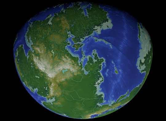
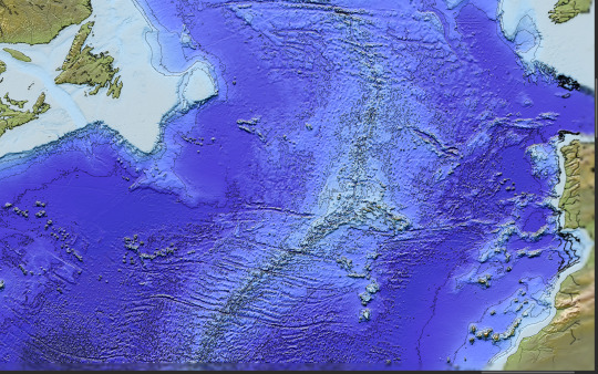
#bathymetry
Photo

Map showing Terrain and Bathymetry of Great Lakes
by u/hemedlungo_725
265 notes
·
View notes
Text


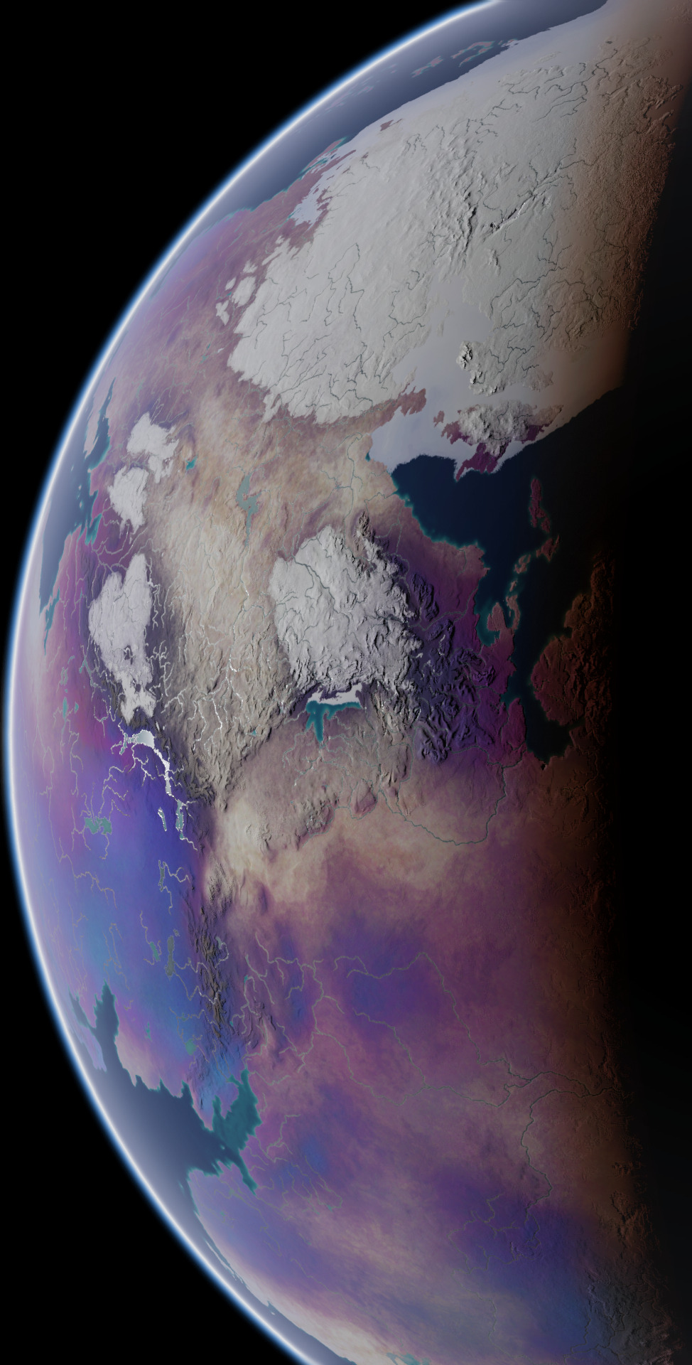


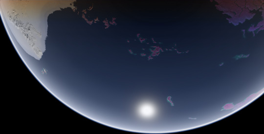

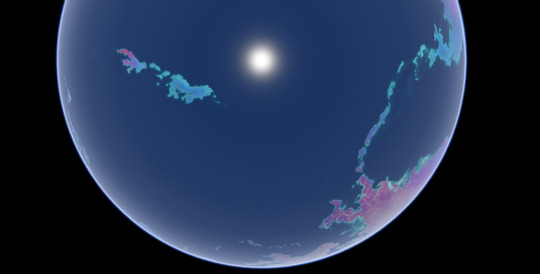
These screenshots I took in Blender are the final product of a commission I worked on for over a year, of my client's planet Ayrum. These represent the planet as it appears at the Northern Spring Equinox, at various angles and different times of day. This project had multiple phases and produced many maps and figures, so I'll be making multiple posts about it over the course of multiple days, working from the earliest results up to the images used in these screenshots.
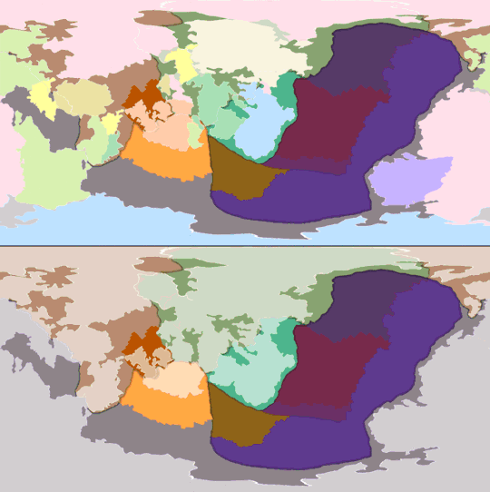
First, the tectonic history sequence, covering about 600 million years of activity. The colors of continental crust in the gif's top half represent which plate it will belong to in the end, and the colors used in the bottom half represent what plates they belong to at the time
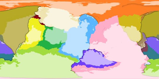
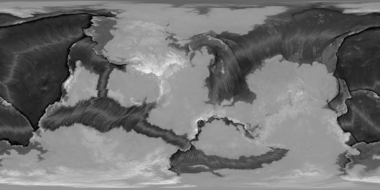
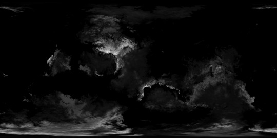
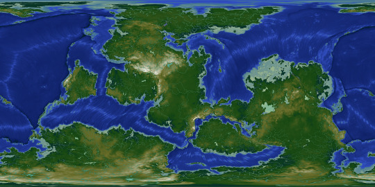
With the tectonic history settled, it's easier to determine what the topography should look like. The two greyscale elevation maps start from the lowest trench depth and from sea level respectively, and the color-graded elevation map has dry land differentiated from bodies of water.


Dipping into Blender once again, with some screenshots where I used the color-graded elevation map as the image texture and the greyscale elevation map as the displacement texture, to emphasize the topography. This will be all for today, but there is much more to come.
These maps were made for the user @umbrace-ramble, to whom I am very thankful for this commission and all the experience it inspired me to gain.
Rendered in Photopea with the aid of Blender,
screenshots taken in Blender,
November 2022-January 2024
#mapmaking#worldbuilding#first posts of many#commission#Blender#digital painting#Photopea#plate tectonics#topography#elevation#bathymetry#imaginary tectonic timeline#imaginary geology#long term project#Christopher Maida Artwork
100 notes
·
View notes
Text
A friend just notified me that it is the annual Day of the Seafarer so here's a free comic about crossing the Pacific on an oceanographic research vessel to celebrate! (This voyage was also the source of the most popular thing I've ever put on Tumblr.)
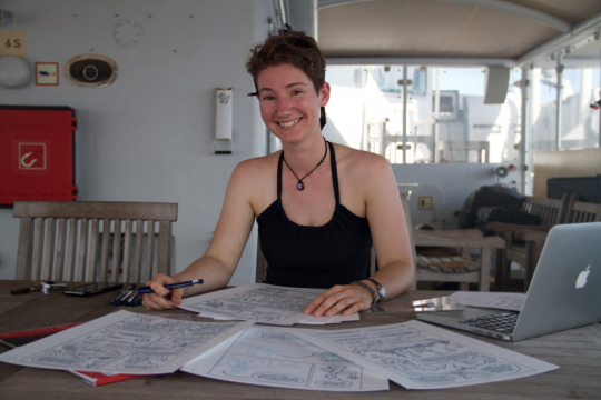

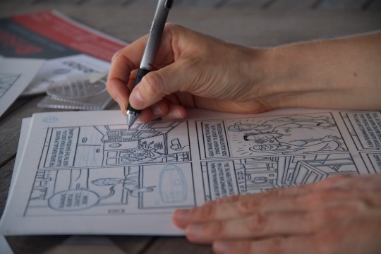
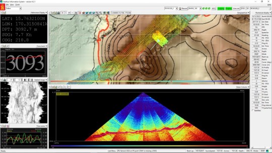
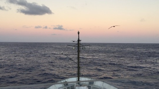
Read the whole comic here.
#MappinTheFloor#R/V Falkor#adventure cartoonist#OceansWorthProtecting#comics#nonfiction comics#comics journalism#marine science#oceanography#schmidt ocean institute#personal work#free comic#bathymetry#lucy bellwood
97 notes
·
View notes
Text
Hot mallu sharmili aunty seducing young servant with her boobs
Stacked Sheridan Love takes a break to fuck herself
Busty Teen Pees On Laundry
Strict College Dean Ginger Speer Fuck by Student with a big young cock
Emo sex gay porn vids first time The camera guy went out again
MOM.XXX Interracial bondage fantasy with ebony latina milf Luna Corazon
Clit spanking
black girl fucks here self to a huge squirting orgasm
Hot teen gives head then bows over and gets drilled hard
sloppy blowjob with lanja for a dollar
#succursale#workbook's#isodimorphism#gunshop#amanuensis#radiotracer#ulmo#bathymetry#lithotype#neuron#feudatory#sootproof#candied#arthropods#Europeanizing#pensar#supermartian#feracious#Sicyonian#repurchasing
0 notes
Photo

NOTATIONS IN DRAWINGS
top image: note the elevation numbers in a topographic line drawing: https://socratic.org/questions/how-do-contour-lines-show-hills-and-depressions
topography and bathymetry: https://education.nationalgeographic.org/resource/bathymetry
_ik
1 note
·
View note
Text
hiiiiii Mid-Atlantic Ridge xoxo
#im having an oceanography moment. a bathymetry moment.#downloaded a 1.69 gb topographic map of the globe besties
1 note
·
View note
Text
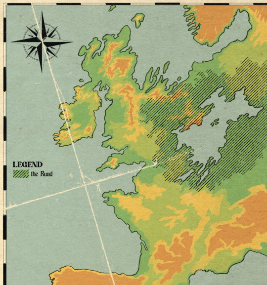


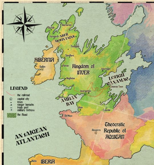
Inver - relief map relative to the continent with otherworld territory marked, broad habitat map, detailed local landmarks map, and political map of the northeast atlantic peninsula as of 1862
i was just having map fun for two days lol. i make habitat maps a lot already but the difference with this one is that i can't just download a handy shapefile and do some GIS magic. this was hand drawn (but obviously. somewhat traced over the actual irl map)
for the outline of the north sea coast i used bathymetry data to figure out where the true coastline would occur. the north sea recedes but the atlantic doesn't (to the same extent). because this landmass was formed through some ancient Event, i felt pretty okay about changing the bedrock because like, whatever, we can't be fully realist all the time. so the northern half of inver is mainly limestone, the southern half is silicaceous - so we got the bog/marl divide there, though lough cánamac (in volume slightly larger than any of the north american great lakes) appears to be the remnant of the north sea, it is freshwater with a relatively low pH. the water of the lough is black to dark brown due to the run-off from the southern bogs and swamps.
in the north, the mountain ranges are calcareous. calcareous grassland, scrubland, heaths and fens dominate with a largely alkaline profile. limestone marl lakes which regularly flood due to groundwater input make the region pretty unsuitable for crops other than rice.
the ruad is the name for a stretch of otherworld territory which contains the lough, though generally used to refer to the forested area. it is completely uninhabitable throughout the majority of its range due to the non-euclidian structure of the land making it impossible to navigate consistently, and the strange and frequently hostile creatures living there. the ruad is faery territory and belongs to an entity known as the Red King, who uses the symbol of a stag. so although inver may look like a large country compared to its neighbours, it has a relatively small population concentrated on the west coast.
however, sailing across the lough is the quickest way to trade with countries in the east, far quicker than trekking through the forest and over land. the trade route through the ruad from invergorken to the cánamac town is one of the most valuable in the continent. it consists of an old road with regularly-spaced ranger safehouses and patrols, and a newer pair of railway lines which can cut through the supernatural aura of the ruad due to their iron rails. the first and older line is no longer in regular use. it was constructed before the development of wrought iron and before the build crews learned how to blast through rock, so it takes a very slow and winding route and required a lot of maintenance. safehouses were constructed to board the workers while the tracks were laid. but without this original track, the construction of the second, far more advanced wrought iron track would have been impossible. workers for the second track were able to commute and sleep on the first track's train, keeping them from harm. the second track can fit two trains side by side and is in constant use ferrying cargo and passengers between the two towns
the country of inver, once The Event wiped out all of its original inhabitants a couple thousand years ago, was settled by hibernians and vikings from the north moving south, and aquitanians from the south moving north (thus the place names). the ruad mostly blocked incursions from the east. there was a long history of dispute over who truly owned the land, and that remained sort of up in the air for most of its history until the 1400s when armorican warlords (like Olivier) decided to make it theirs for realsies and waged war against their old hibernian trade partners (like Finbarr) for control of the land. the hibernians lost because finbarr fucked it up at the last second, and this cemented a ruling class of werewolves in inver until the 1860s
inver consists of three large duchies which cover 70% of the population. Moya in the west is the heart of lycanthrope rule, everybody worships a faery known as the immortal hound and the ruad is far enough away that it is not a fact of life as it is for everyone else. Inver duchy covers the capital city and the south-western farmland, the main sites of production in the country. And Cánamac duchy covers the trade port in the lough and surrounding territories, where forest clearing has led to new farmland and a thriving population. There was a fourth duchy in the north, Aber, but it was historically somewhat isolated and cut off from the south of the country and had developed its own customs and traditions, and its own form of the country's currency. In the 1840s, the duchy of Aber was dissolved and reconstituted into the king's lands, and southern customs were enforced in the north to prevent any more divergence. the palaces of the ruling families in each territory are shown in the local map alongside the family names.
Due to The Event causing massive damage in this region of Europe, forbidding the development of britain and france etc as colonial empires, the last great Empire of this continent was the roman empire, and even that didn't manage to overcome the Ruad. technology is rudimentary in Inver and the people living there are largely considered to be weird backwards superstitious barbarians. aquitan has been threatening annexation for decades, led mainly by the church of suzette, which forbids interaction with otherworld entities. the church holds in disregard the nobility of inver and their cultish ways, and as a result has been banned from attempting to convert inver citizens. but the church is still allowed to make minor inroads into inver for one very important reason: penicillin and antibiotics are the sole creation of the church, and the secret of how they are made is unknown outside suzette. so for the sake of good, advanced healthcare, the church is allowed to set up clinics and hospitals, on the condition that nobody is converted, and members of the church are strictly banned from engaging in any business but importing and selling antibiotics
#ignore me using the wrong orthography in several places#setting: inver#northeast atlantic peninsula bro what happened to u... oh no.. he died...#none of that is spoilers under the cut it's just like. basic history everyone knows
524 notes
·
View notes
Text
Fic Masterlist
It Comes in Waves - Law x gn!reader
∞ Deep Water Waves, Tsunami, Capillary, Surging, Plunging, Surging, Tidal, Breaking, Internal, Seiche, Spilling, Refracted, Progressive, Kelvin, Corduroy Swell, Neap Tide, Shoaling, Diffraction, Fetch, Grinding, Trough, Whitewater, Peak, Crumbly, Wind Chop, Leftover, Amplitude, Bathymetry, Closeout
Childhood Crush - Killer x gn!reader
∞ Mo Laochain, Tungsten, Steel, Carbon, Copper, Brass, Alloy, Wrought Iron, Cast Iron, Nickel, Tin, Zinc, Stainless, Cobalt, Magnesium, Bronze, Titanium, Silicon, Praseodymium, Vanadium, Adamantium, Lithium, Bismuth, Gold. Smutilogue (afab, amab)
Star-Crossed - Corazon x gn!reader
∞ Zemra, Cridhe, Serce, Calon, Bihotza, Cuore, Sydän, Cœur, Hart, Cor, Süda, Szív, Sartse, širdies, Coração, Sŭrtse, Harts, Sydän, Core, Sirds, Kardiá, Corazón, Smutilogue (afab, amab)
Smut Pieces
∞ Not So Childhood Crush (afab, amab)
Favorite View - afab, amab
Beer Pong
Recovery - afab, amab
The Walk-in - afab, amab
58 notes
·
View notes
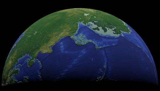
Photo

Bathymetry of the Atlantic Ocean.
by researchremora
283 notes
·
View notes
Text
youtube
Among many other questions on the various sites I posted my latest mapmaking project to, a couple people asked how I created the heightmaps for the Ayrum commission, and so I made a video going over some of my methods in a minor example project. Enjoy!
#Photopea#digital painting#video tutorial#screen recording#showing my work#rendering elevation and bathymetry#mapmaking#Christopher Maida Artwork#Youtube
6 notes
·
View notes
Text
google earth doesn't have any kind of depth scale, so i can't tell if bathymetry is just less detailed than land elevation data, or if continental shelves are really just incredibly smooth.
38 notes
·
View notes
Text

Oh dear Goddess but have I finally solved this problem I've been hacking at in Terragen for all this while?! ...Wow.
This is a shot of the alternate Earth on which the Middle Kingdoms are situated, viewed from about a million miles out (as opposed to any much closer map view).* The North Arlene peninsula is clearly visible at about halfway out to the nine o'clock position on the globe. (In fact, almost a little too clearly visible. I swear to everything, that clear space around it is not something I engineered on purpose! It's just how the NASA-based whole-planet cloud pack from this page at SolarSystemScape.com fell when I applied it.)
Still a lot of technical and artistic work to do on this before I'm done with it, as Terragen has many many MANY ways to customize imaging done from outside the atmosphere (even though it wasn't specifically built for that).** All the under-the-hood maps and images controlling terrain elevation and bathymetry, as well as the actual colors of terrain, oceans, polar caps, etc. etc., have to be repainted and detailed so that I can replace the very basic world maps used in this rendering. But at least now all the continents are appearing where they ought to—an issue that I've been struggling with for actual years (on and off since 2017 or so).
All praise to the lovely person or persons running the TerraTuts series of tutorials on YouTube. That's where I found out what I'd been doing wrong and how to put it right! ...Now I can just get on with the business of making this look more realistic...
*As in this view of our own Earth from the DSCVR:EPIC satellite.

...My sources inform me that a Dragon can make it out to this distance in about thirty seconds: twenty-five seconds to get out of Earth's atmosphere at a decorous speed—because it's thought to be gauche to do any significant percentage of c inside what we would consider low earth orbit—and another five seconds to get from LEO out to the million-mile mark.
**To get a glimpse of the kind of thing it was built for: take a look at the video here (https://youtu.be/JWb9v8OB8HA) of the very handsome Paramount 100th-anniversary trailer. One of the great strengths of Terragen has always been the way it handles clouds, and that's very much on display in this trailer.
124 notes
·
View notes
Note
hi i just finished your fic from 2018 "Bathymetry", and even though its now 6 years old I just wanted to say that i loved every minute of reading it and will be returning in the future. thank you for writing such an amazing fic 6 years ago about a 12 year old franchise that no one really thinks about anymore!
thank you!!! this is so kind, I have a lot of fondness for that fic and I’m glad folks are still reading my longform itemized list of opinions about dishonored <3 the outsider is forever and so is my beloved billie lurk!!
10 notes
·
View notes
Text
Southern Ocean
In 2000, the Southern Ocean is the newest ocean recognized by the International Hydrographic Organization.
It borders Antarctica in its entirety.
In terms of size, it’s the fourth-largest at 20,327,000 square kilometers. It extends out to 60 degrees South latitude.
It’s an extreme environment and is the least understood of the 5 oceans. This is because it is unexplored, far from populated areas, and has a severe climate. Despite the Southern Ocean being unexplored, about 80% of all oceans in the world are unexplored. There’s still a lot of work to do for ocean exploration.
Includes: Amundsen Sea, Bellingshausen Sea, part of the Drake Passage, Ross Sea, a small part of the Scotia Sea, Weddell Sea, and other tributary water bodies
Area
Total Area: 21.96 million sq km
Area - Comparative: Slightly more than twice the size of the US
Coastline: 17,968 km
Climate: Sea temperatures vary from about 10 degrees Celsius to -2 degrees Celsius; cyclonic storms travel eastward around the continent and frequently are intense because of the temperature contrast between ice and open ocean; the ocean area from about latitude 40 south to the Antarctic Circle has the strongest average winds found anywhere on Earth; in winter the ocean freezes outward to 65 degrees south latitude in the Pacific sector and 55 degrees south latitude in the Atlantic sector, lowering surface temperatures well below 0 degrees Celsius; at some coastal points intense persistent drainage winds from the interior keep the shoreline ice-free throughout the winter
Ocean Volume: 71.8 million cu km
Percent of World Ocean Total Volume: 5.4%
--------------------------------------------------------------------------
Bathymetry
Continental Shelf: A rather flat area of the sea floor adjacent to the coast that gradually slopes down from the shore to water depths of about 200 m (660 ft). Dimensions can vary: they may be narrow or nearly nonexistent in some places or extend for hundreds of miles in others. The waters along the continental shelf are usually productive in both plant and animal life, both from sunlight and nutrients from ocean upwelling and terrestrial runoff. Compared to the continental shelf found in other oceans, in Antarctica the continental shelf is narrower and much deeper. In addition, the continental shelf has been deeply scoured by glacial action.
Astrid Ridge
Belgrano Bank
Gunnerus Ridge
Hayes Bank
Iselin Bank
Continental Slope: Where the ocean bottom drops off more rapidly until it meets the deep-sea floor (abyssal plain) at about 3,200 m (10,500 ft) water depth. The deep waters of the continental slope are characterized by cold temperatures, low light conditions, and very high pressures. Sunlight does not penetrate to these depths, having been absorbed or reflected in the water above. The continental slope can be indented by submarine canyons, often associated with the outflow of major rivers. In the case of Antarctica, the continental slope has been scoured by glacial action cutting troughs and canyons down the slope. Another feature of the continental slope are alluvial fans or cones of sediments carried downstream to the ocean by major rivers and deposited down the slope.
Southern Ocean
Amery Basin
Filchner Trough
Hillary Canyon
Pobeda Canyon
Abyssal Plains: At depths of over 3,000 m (10,000 ft) and covering 70% of the ocean floor, are the largest habitat on earth. Sunlight does not penetrate to the sea floor, making these deep, dark ecosystems less productive than those along the continental shelf. Despite their name, these “plains” are not uniformly flat; they are interrupted by features like hills, valleys, and seamounts.
Amundsen (Abyssal) Plain
Enderby (Abyssal) Plain
South Indian/Australian-Antarctic Basin
Southeast Pacific/Bellinghausen Basin
Weddell (Abyssal) Plain
Mid-Ocean Ridge: Rising up from the abyssal plain, is an underwater mountain range, over 64,000 km (40,000 mi) long, rising to an average depth of 2,400 m (8,000 ft). Mid-ocean ridges form at divergent plate boundaries where two tectonic plates are moving apart and new crust is created by magma pushing up from the mantle. Tracing their way around the global ocean, this system of underwater volcanoes forms the longest mountain range on Earth. Fracture Zones are linear transform faults that develop perpendicular to the line of the mid-ocean ridge which can offset the ridge line and divide it into segments.
Pacific-Antarctic Ridge
Undersea Terrain Features: The Abyssal Plain is commonly interrupted by a variety of commonly named undersea terrain features including seamounts, guyots, ridges, and plateaus. Seamounts are submarine mountains at least 1,000 m (3,300 ft) high formed from individual volcanoes on the ocean floor. They are distinct from the plate-boundary volcanic system of the mid-ocean ridges, because seamounts tend to be circular or conical. A circular collapse caldera is often centered at the summit, evidence of a magma chamber within the volcano. Flat topped seamounts are known as guyots. Long chains of seamounts are often fed by "hot spots" in the deep mantle. These hot spots are associated with stationary plumes of molten rock rising from deep within the Earth's mantle. These hot spot plumes melt through the overlying tectonic plate as it moves and supplies magma to the active volcanic island at the end of the chain of volcanic islands and seamounts. An undersea ridge is an elongated elevation of varying complexity and size, generally having steep sides. An undersea plateau is a large, relatively flat elevation that is higher than the surrounding relief with one or more relatively steep sides. Although submerged, these features can reach close to sea level.
Akopov Seamounts
De Gerlache Seamounts
Endurance Ridge
Marie Byrd Seamount
Maud Rise
Scott Seamounts
Ocean Trenches: The deepest parts of the ocean floor and are created by the process of subduction. Trenches form along convergent boundaries where tectonic plates are moving toward each other, and one plate sinks (is subducted) under another. The location where the sinking of a plate occurs is called a subduction zone. Subduction can occur when oceanic crust collides with and sinks under (subducts) continental crust resulting in volcanic, seismic, and mountain-building processes. Subduction can also occur in the convergence of two oceanic plates where one will sink under the other and in the process create a deep ocean trench. Subduction processes in oceanic-oceanic plate convergence also result in the formation of volcanoes. Over millions of years, the erupted lava and volcanic debris pile up on the ocean floor until a submarine volcano rises above sea level to form a volcanic island. Such volcanoes are typically strung out in chains called island arcs. As the name implies, volcanic island arcs, which closely parallel the trenches, are generally curved.
South Sandwich Trench; the deepest location in the Southern Ocean
Atolls: Due to the extremely cold water there are no atolls in the Southern Ocean
--------------------------------------------------------------------------
Highest Point: Sea Level
Lowest Point: Southern end of the South Sandwich Trench -7,434 m unnamed deep
Mean Depth: -3,270 m
Ocean Zones: Composed of water and in a fluid state, the ocean is delimited differently than the solid continents. The ocean is divided into three zones based on depth and light level. Although some sea creatures depend on light to live, others can do without it. Sunlight entering the water may travel about 1,000 m into the oceans under the right conditions, but there is rarely any significant light beyond 200 m.
The upper 200 m (656 ft) of the ocean is called the euphotic, or "sunlight," zone. This zone contains the vast majority of commercial fisheries and is home to many protected marine mammals and sea turtles. Only a small amount of light penetrates beyond this depth.
The zone between 200 m (656 ft) and 1,000 m (3,280 ft) is usually referred to as the "twilight" zone, but is officially the dysphotic zone. In this zone, the intensity of light rapidly dissipates as depth increases. Such a minuscule amount of light penetrates beyond a depth of 200 m that photosynthesis is no longer possible.
The aphotic, or "midnight," zone exists in depths below 1,000 m (3,280 ft). Sunlight does not penetrate to these depths and the zone is bathed in darkness.
--------------------------------------------------------------------------
Natural Resources: Probable large oil and gas fields on the continental margin; manganese nodules, possible placer deposits, sand and gravel, fresh water as icebergs; squid, whales, and seals - none exploited; krill, fish
Natural Hazards: Huge icebergs with drafts up to several hundred meters; smaller bergs and iceberg fragments; sea ice (generally 0.5 to 1 m thick) with sometimes dynamic short-term variations and with large annual and interannual variations; deep continental shelf floored by glacial deposits varying widely over short distances; high winds and large waves much of the year; ship icing, especially May-October; most of region is remote from sources of search and rescue
Geography - Note: The major chokepoint is the Drake Passage between South America and Antarctica; the Polar Front (Antarctic Convergence) is the best natural definition of the northern extent of the Southern Ocean; it is a distinct region at the middle of the Antarctic Circumpolar Current that separates the cold polar surface waters to the south from the warmer waters to the north; the Front and the Current extend entirely around Antarctica, reaching south of 60 degrees south near New Zealand and near 48 degrees south in the far South Atlantic coinciding with the path of the maximum westerly winds
--------------------------------------------------------------------------
Enviornment
Enviornment - Current Issues: Changes to the ocean's physical, chemical, and biological systems have taken place because of climate change, ocean acidification, and commercial exploitation
Enviornment - International Agreements: The Southern Ocean is subject to all international agreements regarding the world's oceans; in addition, it is subject to these agreements specific to the Antarctic region: International Whaling Commission (prohibits commercial whaling south of 40 degrees south [south of 60 degrees south between 50 degrees and 130 degrees west]); Convention on the Conservation of Antarctic Seals (limits sealing); Convention on the Conservation of Antarctic Marine Living Resources (regulates fishing) note: mineral exploitation except for scientific research is banned by the Environmental Protocol to the Antarctic Treaty; additionally, many nations (including the US) prohibit mineral resource exploration and exploitation south of the fluctuating Polar Front (Antarctic Convergence), which is in the middle of the Antarctic Circumpolar Current and serves as the dividing line between the cold polar surface waters to the south and the warmer waters to the north
Climate: Sea temperatures vary from about 10 degrees Celsius to -2 degrees Celsius; cyclonic storms travel eastward around the continent and frequently are intense because of the temperature contrast between ice and open ocean; the ocean area from about latitude 40 south to the Antarctic Circle has the strongest average winds found anywhere on Earth; in winter the ocean freezes outward to 65 degrees south latitude in the Pacific sector and 55 degrees south latitude in the Atlantic sector, lowering surface temperatures well below 0 degrees Celsius; at some coastal points intense persistent drainage winds from the interior keep the shoreline ice-free throughout the winter
--------------------------------------------------------------------------
Ports and Terminals
Major Seaport(s): McMurdo, Palmer, and offshore anchorages in Antarctica
Note: Few ports or harbors exist on the southern side of the Southern Ocean; ice conditions limit use of most to short periods in midsummer; even then some cannot be entered without icebreaker escort; most Antarctic ports are operated by government research stations and, except in an emergency, are not open to commercial or private vessels
5 notes
·
View notes
Text
To the two fandoms I currently write for (The Little Mermaid 2023 and Bridgerton) since ao3 is down because of the ddos attack (and may be down for WEEKS) would y’all read my fanfiction if I uploaded and updated here until ao3 is back up? Cause I don’t want to deal with FFN again….
I’m happilyinsane13 on ao3. I’ve been writing the Uncharted series (Eric/Ariel) that begins with “Bathymetry of the Heart,” and in the Bridgerton fandom im writing Benelope/Penedict (Benedict/Penelope), both “some of its transcendental (some it’s just really dumb” and “sometimes life (slips in through a backdoor)”.
Thoughts?
#fanfic#the little mermaid#the little mermaid 2023#ariel x eric#eric x ariel#benelope#bridgerton#benedict bridgerton#bridgerton fanfiction#penedict#penelope featherington#ao3#fanfiction#archive of our own#tlm live action#ao3 fanfic#ao3 writer
21 notes
·
View notes
Last Seen Blogs

the-night-in-your-eyes
Night

sinkingnotsoslowly
Autumn sighs

spaaaaaaaark-uwu
sideblog for untagged stuff

lucielmars
luci-el

sansybooy
san