#you can sit at the base of a waterfall at the bottom of a gorge!!
Text
Screaming crying throwing up about the fact that I can't go hiking again today
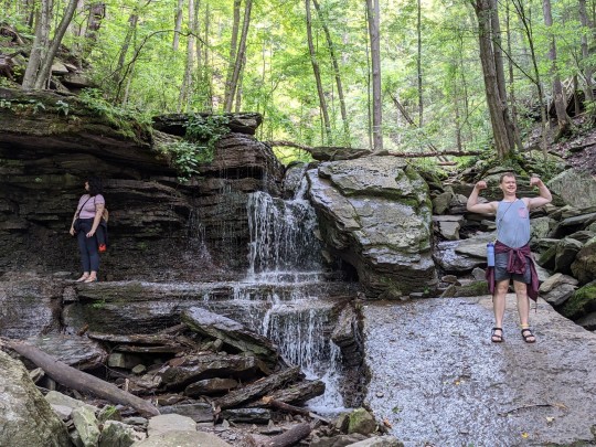
#the smoke from the Canada wildfires has reached here and it's pretty bad#my breathing isn't where it should be between that and going hiking yesterday#BUT I WANNA GO SO BAD#THE SPOT IS SO PRETTYYYYYYYY#you can sit at the base of a waterfall at the bottom of a gorge!!#everything's super green this time of year!!#climbing back up out of the gorge is like being in a jungle gym!!#it's so much fun and I had forgotten about it before yesterday and this is my last day here!!#but I can't fucking GO because my fucking LUNGS won't COOPERATE
0 notes
Text
On Stray Kids' FNF
The song was already on my "songs that might make me cry (depending on my mood) playlist," but with the video, I'm now a sobbing mess
The song was written by Chris and Felix after the bushfires in 2019-2020 and the feelings of loss of so much of the native environment of their home.
I was okay until it cut to Seungmin riding a bike and enjoying being outside.
I miss outside. I want to be out exploring and finding all sorts of plants and animals I've only seen in photos. I want to run along a trail and climb over rocks and ride down a river again.
I want to be able to take photos of things I find beautiful. I want to be able to sit in the park and paint the scenery like Hyunjin. I want to explore new cities and sit outside at a cafe like Lee Know. I want to read a book in the sun like Felix. I want to have fun with my friends on the beach.
I started having trouble keeping up with my friends' activity levels when I was 12. If I tried to run and climb and keep pace with everyone else, I'd go into bronchospasm. I started getting left behind. When I was struggling to climb the stairs back up Tallulah Gorge at 13 years old because I couldn't breathe, one friend lagged behind to stay with me so I wouldn't be completely left behind.
I was treated like I just didn't do enough in my free time. Like I just wasn't outdoorsy or just didn't try. It didn't matter that I loved animals and the science of nature or that if you gave me access to a pool I would spend all day in it. It was my fault that I couldn't breathe or started to feel sick or started having difficulties with heat that would make me nearly pass out even though I had the same activity level as most of my friends and drank the same amount of water or more or ate the same amounts of food. It didn't matter that I met getting launched from a raft or stuck at the bottom of a waterfall with laughter and eagerness to get back on the river. It didn't matter that I always wanted to see the snake or the bug or the weird thing someone found in the woods.
I just wasn't "outdoorsy."
When the outdoors makes you sick, its easier to not be outdoorsy.
In Japan I had more chance to be outdoors again. I still struggled to climb up the "easy date outing, women in low heels, and children can gmdo it mountain," but I figured that was because I was used to the flatness of Tampa and Middle GA, not mountains.
I was able to go to parks and enjoy the outdoors a little more over time because I was walking all the time. I did get a little more heat acclimated, but I also knew how to correct for the amount I was sweating and could control when I got into air conditioning more than I could at a band practice. Running still wasn't an option (I pretty much stopped running outside of emergencies at 13 because of the bronchiospasm) so I couldn't play soccer with my friends, but I could still cheer them on. I was unfortunately dealing with too much anxiety to do all the things I wanted to be able to do on my own.
I continued at that level of able to be outside and okay walking and at a casual pace for a while. I could do shorter, strength based work like carrying things across camp or setting up a tent, and I could walk for miles with just normal muscle fatigue.
Then late 2015 the ability I had started to fall away. I've been trying to get it back since then. Chasing after the ability I did have and longing for a life where I could just walk my dog around my neighborhood without having to plan the whole day around it. Wishing I didn't spend 75% of my time on a queen size mattress.
Ive been trying so hard. I've looked for any answer. Any remedy. Any experiment I can run on myself to try to claw some of my life back. Since November 2021, I have gotten some back. A tiny bit, but some. I have proper diagnoses. I have more science to try to piece together my medical puzzle. I've struggled with my body and my brain, trying to understand so I can try to make things better. I have a sleep study coming up that will hopefully lead to improvements. I have an experiment next week that could really help or it could be a really awful waste of time.
I'm trying so hard to catch up with the life I wish I had.
"I run and chase after you, even if it's impossible."
#my life#stray kids#skz#disability#mast cell activation syndrome#ehlers danlos syndrome#myalgic encephalomyelitis#me/cfa#heds#mcas#my og#long post#not proofread
3 notes
·
View notes
Note
Big question. I need your opinion on something. If Mipha was never saved, and Vah Ruta was never calmed, what effect would it have on Hyrule. We know that it will flood, however I doubt the Shiekah would have the ability to create water from nothing (like to gods) so I just assume they are teleporting so the ocean won't rise. With this in mind, none of the major settlements would really be affected. Gerudo Town is far enough out of the path that the river would take through lake Hylia, Riti Village is also out of the way, and not only does it have a natural moat (if you could call it that) but also a canyon in the way. Korok Forest has magic and a moat and is also out of the way, Goron City is also to high up and out of the way, Tarrey Town is really highup and out of tge way, Zoras domain has pretty good drainage and it will probably go through the several other exits to not cause that muc damage, Kakariko Village is safe in the mountains, Hateno Town is safe and out of the way, and Lurelin Village is also out of the way and won't be damaged unless the ocean floods.
WOO LET’S FLOOD A CIVILIZATION AND SEE WHAT HAPPENS!
**Zelda meter is the meter system of objmap.zeldamods.org, but in accordance with previous posts I'm gonna convert it later to "actual" meters that I think is more realistic. You’ll see why later.
ALRIGHTY, SO LET’S START WITH MEASURING TIME!
So, East Reservoir Lake is 545 zelda meters long (light blue) and 340 zelda meters wide (blue)
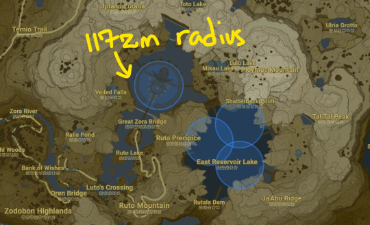
Or if we want to see it as more of a circle, it has a radius of 239 zelda meters
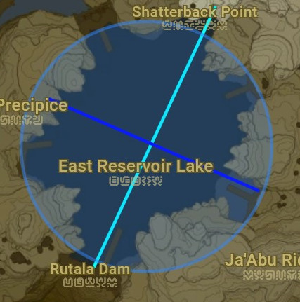
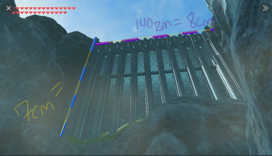
Rutala Dam itself is 30 zelda meters wide and 140 zelda meters across. (see purple)
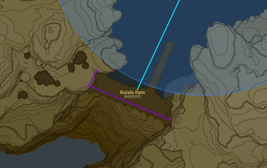
Taking a picture and using an online ruler, I found that the damn is roughly 123 zelda meters tall. (1 cm equal to 17.5 zelda meters by using the 140zm measurement)
Technically speaking, the dam's depth is infinite in the game, so we'll just use this damn's height as the depth.
And before you tell me that I should count the height of the rocks that the damn sits on top of as part of the depth, I'm gonna say not because dams typically block preexisting waterfalls, and given the rounded erosion of the rocks here, I would say that is also the case. Therefore, this was a waterfall that fed into the Rutala River and is not counted for the reservoir's depth.
So, in summary:
Reservoir Length: 545zm
Reservoir Width: 340zm
LW Reservoir Surface Area: 185,300zm (That is only 0.1 zelda kilometer. For comparison, the 45th largest reservoir in the world, Capivera Dam [last place on Wikipedia list] is still 515 square kilometers. The largest ones being in the 60k areas. I’ll come back to this point later.)
Reservoir Radius: 239zm
(pi)r^2 Reservoir Surface Area: 179,451zm2 (179zkm2) [Just got these numbers of surface areas to demonstrate they're practically the same whether you see it as circular or rectangular. I think the circle will be more accurate so going forward I will be using it as my basis for calculations]
Dam Length: 140zm
Dam Height: 123zm
Dam Width: 30zm
The Total Water Rutala Dam Holds Back: 22,072,473zm3 [Instead of just using the sphere volume formula or the LWH formula, I used my more accurate surface area made with the the radius and multiplied by the dam height(is that the,,,cylinder formula? I think so)]
Rutala Dam is supposed to be the largest reservoir in Hyrule, shown very prominently on the map. The largest reservoir(by surface area) in our world is Lake Winnipeg, with a surface area of 24,514 km2, (but only has a depth of 12 meters.)
But here it is on a map of Canada:

To reiterate, Lake Winnipeg has an area of 24,514km, and with zelda meters, East Reservoir Lake has an area of 179.
“BUT KIP! MAYBE EAST RESEVOIR LAKE IS JUST REALLY REALLY SMALL, HYRULE IS PRETTY SMALL ISN’T IT?”
Ok, so comparing the reservoir to one of the the largest, if not THE largest, settlements in the game, Zora’s Domain, we can see that the reservoir is several times it’s size.
But you’ll also note that Zora’s Domain has a diameter of 234zm. That, the entire city, the entire DOMAIN of Zora. 234 zelda meters. Manhattan is 21,100 meters long. Manhattan, by the way, is a fifth fraction of the New York County, which is the smallest county in the United States of America.
234 zelda meters, that’s an area of 43,005zm2. Do you know what else is aobut 40k meters squared in real life? Your nearest Walmart. Just a bit bigger than your local Tesco. Supposedly the entire Zora population, that has been untouched by the 100 year apocalypse and arguably had room to GROW over this time, is living in a Trader Joes.
So I hope this illustrates why I’m converting the zelda meters used on the website to something that I think would be more realistic in the realm of Hyrule. You can find my very loud and kinda embarrassing but factual! and old post about the conversion here, same link as at the top, but essentially just trust me on the conversation that 1zm is equal to 30 real-life meters.
New Realistic Measurements:
Reservoir Length: 16,350m or 16.35km
Reservoir Width: 10,200m or 10.2km
LW Reservoir Surface Area: 166,770km2
Reservoir Radius: 7170m or 7.17km
(pi)r^2 Reservoir Surface Area: 5,383,530m2 or 5382.53km2
Dam Length: 4200m
Dam Height: 3690m
Dam Width: 900m
The Total Water Rutala Dam Holds Back: 19,865,225,700m3 or 19.8 million cubic kilometers of water AKA 19.8 billion kiloliters AKA 5.2 trillion gallons o’ agua
Now THAT sounds more like the biggest dam in all of Hyrule. In fact, it adds up with the stats of the largest dam in our world(by gallons held), that is, the Three Gorges Dam.
The Three Gorges Dam, located in China, ALSO holds back 5 trillion gallons of water/19 billion cubic meters. Although it is a lot shorter than Rutala’s measurements--I think the amount of water that it holds back will be a perfect guide to see the devastation that Rutala’s potential breakage could cause on Hyrule.
There actually is a simulation online about what would happen if the Three Gorges Dam collapsed but I’m not gonna link it cause it might be a bit too distressing, but just know that I based this on that simulation.
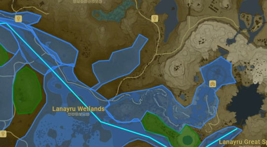
Firstly, the biggest sigh of relief comes from the Samasa Plain.

The plain is very very low and slopes down into the Lanayru Bay, so a lot of the water would empty into there. However, the plain would then be totally submerged, so RIP to the shrines and ruins around there. Areas in red as submerged and areas in green would become islands or marshes.
And with that, the water level of Lanayru Bay would rise drastically. Blue is the new water level, dark green are islands, and light green are potential wetlandish areas that would form as time passed.
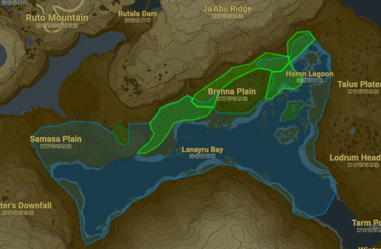
But basically, Rutala river would have a new branch that spills directly into the Lanayru Bay.
So now you may be thinking,
“HEY KIP THAT’S NOT SO BAD! MOST OF IT SPILLS OUT INTO THE BAY SO IT’S NOT A LOT OS DESTRUCTION! YAY!”
And you’d be half right.
Yes, a lot of the water is going to spill out over Samasa Plain and yes, Lanayru Bay will house a lot of it. But here’s the kicker.
It’s a bay.
Not an ocean.
It would take 1.25zkm or 30km for the water to make it’s way to the ocean, and the water will be traveling SUPER fast--about 100 kilometers per hour.
And that water wants to move, it wants to flow, and Lanayru Bay cannot help all that water flower because: It’s shallow as fuck.


This chest shows the deepest point in all of Lanayru Bay.
I dropped a windcleaver down in the water: and using a generous GENEROUS estimate of 2 feet per second given the conditions of the still water in the bay--It took 5 seconds for it to float to the bottom. 10 feet. 3 meters. That’s just barely deeper than the deep end of a backyard swimming pool.
But even being extra EXTRA generous and using a real world estimate: Bays would be around 14 feet deep, roughly 4 meter. And we can be even more generous and say the sounding mountains can accommodate 30 feet of height. 9 meters. 9 + 4 = 14 meter height times 30km by 10km(width) = That’s 4.2 cubic kilometers, or 4.2 billion kiloliters of the 19.8 billion kiloliters in total.
uh oh. wheres the other 15.6 billion kiloliters of water gonna go?
It’s like taking a firehose, and filling up a bathtub. Yeah, the tub’s gonna catch a lot of that water, but that firehose has way, way, way, more water than that tub can hold, and when the tub can have a leak or hole on it, but the rate that that hose is going is astronomically faster than the rate the tub can expel water, so it’s just gonna overflow and water will still spill everywhere
[And this isn’t even taking into the account that Rutala Dam is SIGNIFICANTLY higher that it’s surrounding landscape, and would pour into the river with such a force that it could cause a giant tidal wave and break through the rocky boundaries of the pre-existing Rutala River causing even more water to flow into the bay]
Lanayru Bay would be occupied with a lot of water, and since the other 15.6 billion kiloliters of water can’t immediately flow into it, it’s gonna take the scenic route through Rutala River. It’s high mountains on either side basically just make it a death funnel.
Here’s how that would look:
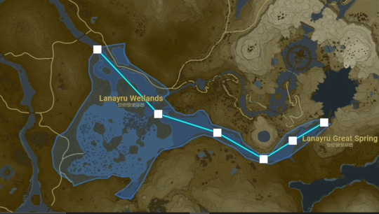
This is the new water level for the Lanayru Wetlands. MAn they weren’t lying, those lands do be wet.
so yeah everything is submerged in between 10 to 20 meters of water and you might be thinking
“WELL KIP, I THINK THAT’S NOT SO BAD AFTER ALL! AT LEAST NO MAJOR LANDMARKS WERE DESTROYED AND NO ONE WAS HURT!”
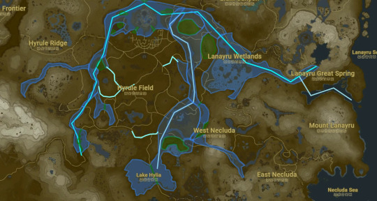
Well, bestie, here’s the thing. This length of land is 3 zelda kilometers long. AKA 90 kilometers long. And you might recall, I said, that this, 3000 meter tall wall of water was traveler at 100km per hour. Well the good news is, my calculations are a lot easier for this as this large stretch of flat Lanayru Wetlands land lines up perfectly with the flat areas of Yichange, (which was actually traveling at twice the speed compared to Rutala because it didn’t have Lanayru Bay to open up into)
But the bad news is, the video is five minutes long, and this is just the first 50 seconds. This water is destined to travel 400 kilometers. That’s about half of the country of Wales, by the way. The entire length of the state of Virginia.
Here’s the rough path of the total flooding that other 16 billion kiloliters from Rutala Dam

Oh, and what’s worse is that the rivers in central Hyrule? Yeah they’re like HALF the depth of Lanayru Bay so the flooding will be even WORSE :D
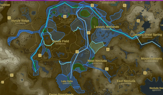
So here’s the new waterlevel map!
Overtime, a lot of the water is gonna spill onto the paths through Central Hyrule, new swamplands, creeks, etc. etc. The path to the Gerudo Desert will be fin initially, as the water as slowed to the point where it won’t put immediate damage since the bridge is so high. But that new water level plus the influx of water from the River of the Dead is definetly gonna erode that over time and maybe possibly will just collapse and prevent anyone from leaving or entering the desert.
Hyrule Castle will be even more of an island, as the two islands to the left and right of it will be moslty submerged. Also the entire path through Eldin is just fucking done. Everyone in Akkala and Eldin? You’re trapped there. It’s basically a new Lake Hylia but no bridge. Sorry Robbie.
Oh, and also these rapid waters are carrying the debris of it’s destruction, whether the corpses of travelers or giant rocks that it broke off from the side of mountains. So everything is a mess, and depending on the amount of debris, it could completly alter water paths to go even more in land. The rivers are shallow enough, so just pilling in more rocks and dam metal and dirt just makes things shallower
Lake Hylia will be fine, the mini islands are gone, but as a whole, the bridge and the height of the surrounding ridges will keep the water in there. Although a lot of Necluda is basically a goner, and the bridge on either end of Dueling Peaks is totally decimated.
So what did we learn?
All of Hyrule’s economy is fucked. Every major trading path--gone. It’s basically gonna breed even more ethnocentricism, and a bunch of wildlife and sources for food are gone. And not to mention the climate, that’s gonna be fucked too as years pass. Rito and Zora will probably be the most fine? Hylians are fucked though, we destroyed like five stables and basically every river setllement there is. Oh and that influx of water is gonna fuck with the fishes so Hateno and Lurelin aren’t totally out of it either!
Gerudo? Well good thing they’re all lesbians because they sure aren’t going out to woe anybody once those stone pillars holding the bridge give way to the new water levels. Gorons will actually not even know anything’s wrong if I’m being honest. Sheikah? Well that point by Eagus Bridge and Sarhasra slope is gonna connect into a river at some point so I guess they can be a fishing village now.
Oh an RAIN I didn’t even think about that, yeah people are totally gonna die. And if Ruta CONTINUES to pump water into Hyrule (because again, this is only from an INITIAL burst of the damn. Well...
Zora’s Domain will be gone within the year. Water levels will just continue to rise, probably take on Central Hyrule first, but then after that the Gerudo Canyon. Also if flooding in Zora’s Domain REALLY continue it would probably spill over and destroy Tarrey Town. So not good all around!
But I think the main takeaway that we can all settle with is that the Flower Lady and her garden are absolutely, positively, dead.

1K notes
·
View notes
Text
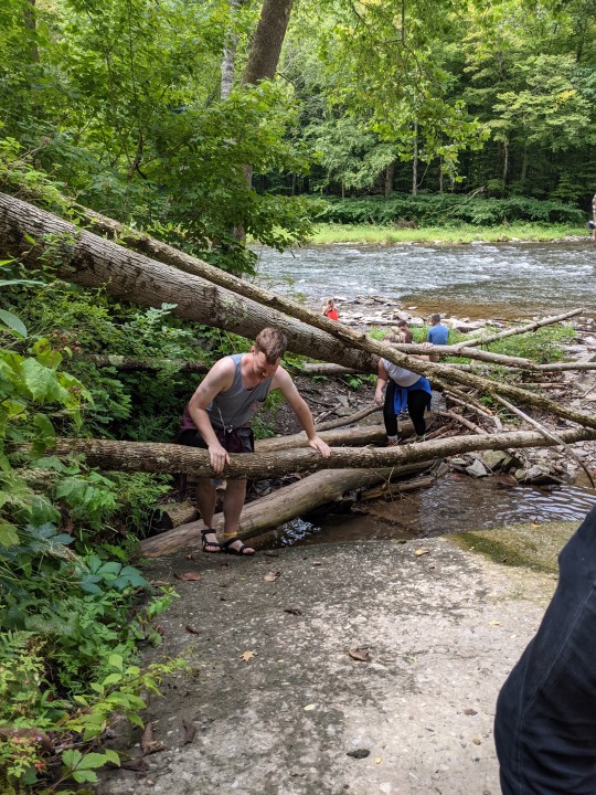
Second and final night at camp. I'm sorry I didn't give a warning these would be posted when we got back. I somehow forgot we wouldn't have service. It's actually be really bad!! Like even when we go down the mountain it's still very hard to get any signal. But it's been great. I'm having a great trip.
Last night was a little scary. It started to rain. And then really storm. With lots of lightening. We weren't sure if we should make the call to sleep in the car. But James thought we were okay and I trust them. And while it was scary for a while it would eventually be calm enough to sleep. It continued to rain. But we were alright. We honestly had a lot of laughs. Like when James accidently hit me in the eye and we could hear Evan and Noelle arguing about how small their new tent is.
We did get a little wet in our tent. The water kind of pooled under us. And we had some leaking to made the bottom of our blankets and pillows got wet. But we were able to move everything around so the clothes we had didn't and we were able to sleep pretty comfortably.
James woke up early. And then accidently set off our car alarm. Oops. But I fell asleep until like 730 before I got up.
It was misty this morning. I went and got dressed and felt good. We would have a pretty excellent breakfast and made our plan.
We went for a hike for a few hours. Everything was still cool from the rain so we had rain jackets on. But would loose them eventually.
The walk down the 1833 foot mountain was great. I have no issue going down hill. The only slight issue was me and Evan wore our Tevas. Was this smart? No! But no blisters at all. We just were slipping in mud and some of the wooden stairs. No one got seriously hurt. I just twinged my shoulder and he smashed his toe.
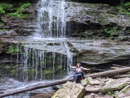
The waterfalls were the best part for me. I had to wait a moment for a couple to leave to go on the path. But it was worth it. I took their picture. And then I climbed all the way over. I would do this at two separate areas of the falls on the way down. And it was great. It felt magical. And I was so happy.
The whole walk down was a lot of fun.
And when we got down there we would walk the trail a little before deciding to go sit by the water and have a snack.
We had our trail snacks. And then went closer to the water. I kicked down people's rock stacks. They are bad to leave!! They can squishy tiny animals. And then we walked up the stream to the waterfall and it was great. We played around there before we started back up the mountain.
This part was decidedly NOT fun. It was still a little humid. And while I was very overheated I was also cold to the touch. Me and Noelle were like. We need to keep stopping to take a break. And it was just really rough. It took a long time to get back up. James sang camp songs that were call and response and that helped me a lot. But it was a really tough walk back. It is all switchback trails so they were particularly steep. But even though my calves hurt a lot. We made it to the top.
We would reward ourselves with snack stand products. Which were all maple based. Including the hit dogs that Noelle and James got. It was very silly but a lot of fun.
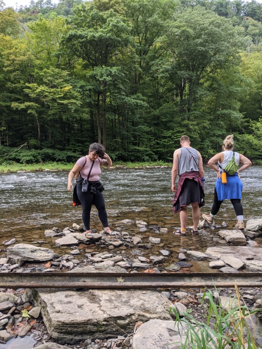
We were all very sweaty and hot st this point. And not entirely sure what the plan was. We were going to go tubing but we weren't sure if the water would be safe for it. And we had no service. So we had to head into town.
We would come back to our site. Lay all our wet blankets and stuff in the sun now that it was out and bright. We got changed. Decided to put bathing suits on just in case. James chopped some more wood. And then we headed out in our new car.
It took forever to get any service. But once we did we started calling and trying the website. But no luck. So we went to the grocery store. Got some chips and some fire starter. And then just decided to go to the tubing place.
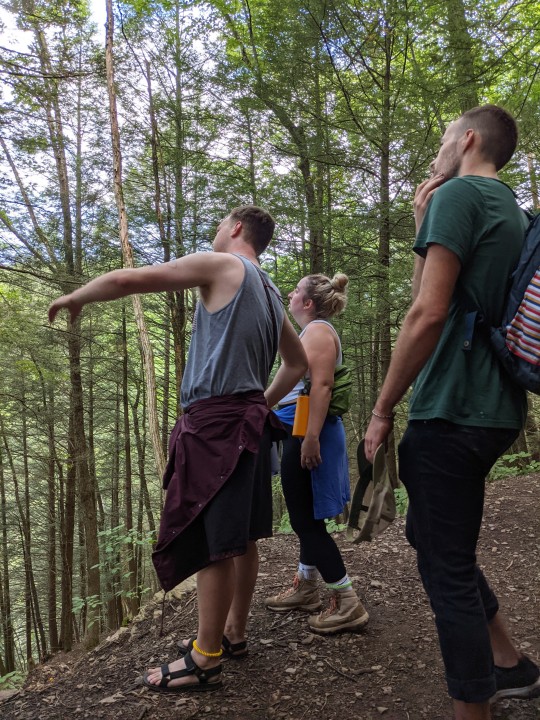
James and Evan went in. They apparently we're very nice but they said the water was to low to tube. Ah well. So instead they gave them a map and showed them an easy trail on the other side of the gorge with pretty views.
So we went there. It was beautiful. And the path was completely flat. We pointed out every mushroom we saw. And it was just so nice.
We got back to the camp site. But first we stopped at the former location of animaland. I don't know why it closed. But I'm real sad about it. It's a gift shop now. And the woman was very nice. She had some of the former attractions souvenirs. So James bought me a mug. And a little wooden mouse. We would also get maple syrup and ice.
We needed wood though. So James took us back to the campsite before they went to search for wood.
We would get changed and then James was back. We worked on a fire. Which was hard because a lot of the wood was damp. But it was okay I'm the end. James used my little far to feed the fire air. And it worked surprisingly well. And then James and Evan made me a grilled cheese which was great.
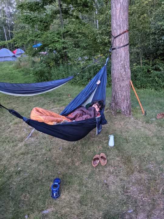
I spent some time reading. Organizing. James would work on cooking and everyone had some roles. I was having allergy issues so I was mostly chilling. I put up the hammocks and would lay here. Eventually getting James to join me. Which was great. Love laying with my partner. Love them so much.
I went to take a quick shower. And put pj's on. And now I'm just watching them make s'mores. And looking forward to some sleep. I hope there are more stars tonight. And no surprise rain.
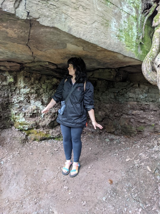
Tomorrow we will leave and go to a cave! I'm excited. I hope you have all have an excellent weekend!!
4 notes
·
View notes
Text
By Bast - Chapter 15 (Erik x Reader)
A/N: Fluffier than expected... I hope it’s not a waste of time lol. Comments, likes and reblogs are appreciated!
The next day, you woke up to the sounds of birds chirping and the soft running water of a nearby stream. Then the widespread itch came. The bugs had gotten you through your robes somehow, and your skin was etched with raised bumps on all four limbs. You sat up under the makeshift lean-to Erik had built in the dead of night and scratched your legs exasperatedly.
Erik was nowhere to be found. You wondered where he had slept, if he did sleep. A small part of you wanted to panic at the thought of abandonment, but instead you pulled your knees to your chest, took a deep breath and focused on observing the terrain around you. He would return, you were sure of it… 90% sure.
By the height of the sun in the sky, you guessed it was about midday. Your stomach finally began to protest yesterday’s antics with a loud grumble and you tried to ignore the gnawing sensation in the pit of your belly. While gorging during T’Challa’s feast had lasted you quite a while, it was finally time to refuel. You shuddered at the idea of having to resort to eating bugs, and silently cursed yourself for not preparing better to camp out in the jungle. Maybe next time you’d pack a survival kit before starting your daring rescue.
“Finally awake, huh?”
Erik was walking towards you carrying a large bunch of greenish-yellow bananas, likely fresh from a felled tree. It was as though he had known you were starving. He tossed them in your direction and while you did catch them, the bunch fell on your lap harder than you expected. Erik ignored your wince of pain and took a seat next to you.
“Better eat fast so we can get going.”
With that, he pulled off two bananas and peeled both, eating them at once. Once he was done, he ripped off the bottoms of his soiled pants, revealing his well-developed calves. Unsatisfied with this, he did the same with the long sleeves of his shirt, tearing them effortlessly to free his arms from the heat.
“Aren’t you worried about mosquitoes?” You asked, peeling your own banana with just the tips of your likely dirty fingers. It was barely ripe, but edible.
“We won’t be out long.” You raised an eyebrow. “You’ll see,” he insisted.
You decided not to question it. The two of you finished the rest of your meal in silence. Eventually, Erik got to his feet and started walking to the north with a purpose.
“Let’s move.”
You hurriedly obliged, ever afraid to be left behind.
---
It was when you finally reached a quaint cabin in the jungle that you had to say something. Your mouth hung open as Erik turned over a large fallen leaf by the side of the structure and pulled out the key that was laying underneath.
“N’Ja-.. I mean, Erik… did you-... are you clairvoyant? What the hell?” You were at a complete loss for words. How had this man legitimately prepared for everything?
He raised an eyebrow at you and then proceeded to unlock the door.
“No-no-no-no-no!” You protested the very sight before your eyes, following him into the small home. While this cabin obviously did not have the luxury of running water, electricity or gas, the fact that Erik had led you to a fully built shelter in the middle of literally nowhere equipped with a bed (!), a wood stove (!!), cabinets (!!!), and a fireplace (!!!!), was just too absurd for you to comprehend.
“This is unbelievable.” You said, swinging one of the cabinets open to reveal stacks of canned soup and beans, beef jerky in sealed plastic and bottles upon bottles of filtered water. “Unbelievable!”
You whipped around in shock, a box of powdered milk in one hand and a jar of peanut butter in the other. “Are you serious?! Is this really yours?”
That last question you probably did not want the complete answer to. “How did you know we’d need this?!”
Erik, for the first time since you met him, started to laugh.
Not the cocky or mocking laugh you were used to, but a true, unbridled, amused laugh. You were so surprised, the box you were holding almost slipped out of your fingers, making him laugh harder. Erik trying to get ahold of himself was humanizing but almost as bewildering as there being a fully stocked cabin in the woods just waiting for the two of you. Almost.
Erik wiped a tear from his eye, and sat down at the small round wooden table next to the stove. He waved you over to sit across from him.
“Put the peanut butter down ma, damn!” He said, his voice still light and entertained. Once you sat, he continued. “I was here for a little while before I showed up… Just planning. You know, in case shit went wrong.”
So he wasn’t 100% certain he’d take over the entire country single-handedly. I could have been fooled, you thought.
“How do you even know this place is safe?” You asked, looking around.
“Trust me, it’s safe.”
“I’ve been trusting you an awful lot in the past 24 hours.” You joked, but his expression darkened, and you let out a nervous laugh.
Erik suddenly got up and headed over to the bed. He grabbed the pillow and wordlessly beat the dust out of the mattress a couple of times before stripping down to his underwear without so much as a warning. Embarrassed, you averted your eyes.
“Shut up for a minute so I can take a quick nap.” He said, curtly. In less than a minute, he was fast asleep. You now were almost certain he’d been up all night.
That was abrupt. You were starting to get the sense that Erik was sensitive. Now what would you do while Erik was asleep?
You got up and continued to look around the cabin. In a closet you opened carefully to prevent creaking, you could find a machete, a fishing pole and a bucket. In a dresser, pushed to the wall opposite the bed, you could find three spare sets of clothing, including a pair of comfortable looking flannel pajama pants and a matching button-down shirt. Five pairs of boxers were neatly folded into one of the drawers. A towel, assorted combs in the other.. a boar bristle hairbrush? You rolled your eyes at the excess of it all. Who was this man trying to look nice for in the entire jungle?
From one of the cabin windows, you could see a cool-running stream in a short walk down a dirt path. It seemed like a good place to bathe, and you should probably take the opportunity while Erik was sleeping. You probably smelled rank anyway.
Walking down the path was mind-clearing, even more so when you could finally shed your dirty robes and slowly submerge yourself into the body of water. Under a small waterfall, you closed your eyes, letting the water crash onto your shoulders.
Water is cleansing. Water is good. Water would wash away your sins, water would replace your good food, your life in the castle. Could it? How long would it be until you were found? How long until N’Jadaka got tired of dragging you around and went off to do whatever men of his ilk did?
You exhaled heavily and sunk deeper into the water, so that you were up to your neck. You could see a couple of the gentler fauna peering from afar to get a drink. Antelope were graceful and kept their distance before drinking but you backed deeper into the base of the small waterfall cliff so that you were obscured from view. You weren’t exactly looking for another jungle cat encounter, especially naked and alone.
Next steps were unclear, and Bast had not said anything in the past day. Now Erik only guided you and while you knew you had some sort of protection from harm from Bast, you were not sure how safe it could keep you from him if he changed his mind. You called out to her again, but no response came. Instead, you continued to sit for the next half-hour.
The next time you peered out, most of the animals were gone so you waded back out to the bank to grab your robes and rinse sweat and grime out of them as well. When you looked up, Erik was coming up the path towards you, but hadn’t spotted yet. Remembering you were naked, you swam back to your hiding spot hoping he wouldn’t spot you. Your heart pounded but he seemed to thankfully pass by you.
You decided to give it a few minutes before making your escape, but then you heard the sound of someone else plunging into the water.
Abandoning the need for discretion, you all but scrambled out of the water to cover up the indecent portions of your body with your sopping wet clothing.
“Ain’t like I’ve never seen titties before!” Erik’s voice rang out from behind as you ran down the path at full speed. You could feel your body grow so hot in embarrassment that you were pretty sure you’d probably instantly air-dried on your way back to the cabin.
--
You couldn’t face Erik once he swaggered back into the cabin. In fact, the moment you heard the front door swing open, you could feel your stomach do backflips. At least this time you were fully clothed, wearing the flannel pajamas you had located earlier while your robes hung to dry.
Erik did not say a word but you could almost feel him smirking as you gestured towards a meal placed on the table, eyes focused on the still burning stove. While he had been bathing, you had tried to figure out the best way to make something edible out of canned beans, instant rice and whatever vienna sausages were. Still, without any spices aside from salt and pepper, the food tasted like it had been doused in sugar and flour and had the texture of something that had been thawed and reheated daily for three weeks.
You put out the fire and turned to finally eat. Erik was already seated and making his way through his plate. Shirt off, he was brilliant to look at and you couldn’t help admiring his built chest. But those scars… You focused on filling your stomach, not your eyes. Shame on you.
Keeping your eyes on your plate, you chewed carefully, suddenly startled by a fork clattering on the table. You looked up at Erik.
“Did I… desecrate you or something?”
Your eyes grew wide.
“What?”
He ran his hands through his dreadlocks, letting out a sigh. “I mean, like, seeing you earlier, titties out and shit. Since you a priestess virgin and all.”
Now you lowered your fork hard on the table.
“Can we just not talk about it?” You asked, sternly, now more annoyed than embarrassed. Erik opened and closed his mouth, deciding against saying whatever he had in mind. Realizing he probably actually wasn’t meaning to be crass, you started to feel bad.
“Okay, well it’s not gonna rain fire and lightning so don’t worry about that.” you offered. “I can tell you’re really from the West with all that puritanical thinking though.”
Erik took your teasing surprisingly well. He smiled warmly.
“Your food tastes like ass, by the way.” He said, clearing his dish off the table.
You frowned. “I tried my best.”
Cheekily, he replied, “I know.”
Tagging: @syndrlla97 @iwantsomethingeternal@1killmonger @chasingsunlight22@hoopshoney @destinio1 @wakanda-inspired @thadelightfulone @lalasparkles @pessimisfit @youreadthatright @stark-red19@ruruly20@bossyboyd03 @autumn242 @heybriheyyy @thelovelyliterary@muse-of-mbaku @bidibidibombaclaat @supersizemeplz@romanceoftheeveryday@chaneajoyyy @lildashofmelanin @blackpinup22 @imayhavemisunderstood @raysunshine78 @killmongersbaby @fonville-designs
#erik x reader#erik killmonger x reader#killmonger x reader#erik x black reader#erik killmonger#black panther imagine#black panther#enemies to lovers#fantasy#slow burn#by bast
45 notes
·
View notes
Text
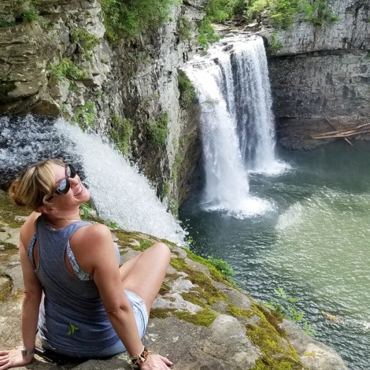
As I blazed a trail through Rockhouse Creek to find this spot, I wondered if the water knew it was about to take the plunge just around the bend...
Is it racing between the banks excited about that plunge, or lazily traveling along then met with a happy surprise?
I have an insatiable fascination with waterfalls, top and bottom alike, no matter what it takes to get there...
They are constant, always appearing the same, give or take conditions & seasons, but that's deceptive. They are constantly changing, renewing by the microsecond, as each drop of water is different than the last, falling over only once and replaced by another - just like your body is constantly renewing itself with new cells.
You can't feel it, you can't see it in the mirror, but you are rapidly changing every second - too. I'm always reminded that I have control over those positive & negative changes in my brain & body, with every choice I make.
It's both humbling and empowering to sit next to a waterfall, enough to give me chills, and a rush of excitement for life!
Do I envy it's easy existence of no good or bad choices, just going with the flow? Or do I feel a deep sense of gratitude for all of my options & opportunities? A little bit of both. 😉
Why are we drawn to oceans & waterfalls? Because our bodies crave the charge!⚡
🌊The collision of water molecules with each other, such as at a waterfall or an ocean beach, causes the water to become positively charged, and the surrounding air to be negatively charged. Those negative ions hitting your bloodstream can produce biochemical reactions linked to alleviating depression, relieving stress, and boosting energy.💧
🌞 Rockhouse Falls is a 125 feet plunge waterfall in Tennessee that marks Rockhouse Creek's confluence with Cane Creek. The waterfall, which shares a plungepool with Cane Creek Falls, is visible from the Gorge Trail and from the base of the Cane Creek Gorge. (- - and from the top if you dare! 😁)
3 notes
·
View notes
Photo
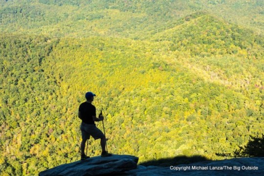
A hiker atop Looking Glass Rock, Pisgah National Forest, N.C.
By Michael Lanza
Warm rain drums lightly on the lush deciduous forest around me as I walk up a long-abandoned dirt road that has narrowed to a trail with the gradual encroachment of vegetation. The wind assaults the treetops, the outer edge of a hurricane hitting the Southeast coast right now; but here, far from the storm, it sounds like waves rhythmically lapping up onto a beach and retreating. It’s a gray, early evening in mid-October in the basement of a compact valley in the Appalachian Mountains of western North Carolina—a valley that, due to its tight contours, sees precious few hours of direct sunlight at this time of year—and the daylight has filtered down to a soft, dim, tranquil quality.
A bit more than a half-mile up this quiet footpath, I reach my destination—and unconsciously catch my breath at what must be one of the most lovely cascades in a corner of North Carolina spilling over with waterfalls.
Roaring Fork Falls tumbles through a series of a dozen or more steps, each several feet high, before coming to rest briefly in a placid, knee-deep pool at its bottom. Beyond the pool, the stream continues downhill at an angle only somewhat less severe than the cascade above. In sunshine or warmer temperatures, I’d be tempted to wade in and sit in that pool. Now, I just stare at it, all but hypnotized.
Roaring Fork Falls, Pisgah National Forest, N.C.
I’m on the last, short hike of a day filled with beautiful waterfalls along the Blue Ridge Parkway, in the heart of one of America’s hiking and backpacking meccas: western North Carolina. I’ve come to spend a week chasing waterfalls, fall foliage color, and classic Southern Appalachian views while dayhiking in the mountains surrounding Asheville and backpacking in Great Smoky Mountains National Park.
Unlike soaring, jagged Western mountain ranges such as the Tetons, High Sierra, or North Cascades, the Appalachian Mountains are lower and mostly forested from bottom to top, their once-sharper angles of ancient epochs worn rounder and softer by erosion and time. (It happens to all of us.) From a high point like Looking Glass Rock, Black Balsam Knob, or any of numerous turnouts along the Blue Ridge Parkway, the mountains here resemble a roiling, green sea of trees.
The West has big vistas; the Appalachians have big vistas, too, but mostly small, more intimate scenery, the kind that you can literally reach out and touch. Here, you don’t just look at the scenery; you’re in it.
In a sense, I went to North Carolina to reconnect with my hiking roots. I became a hiker, backpacker, and climber in the northern reaches of the Appalachian chain—in New Hampshire’s White Mountains and on many other wooded, rocky, rugged, little mountain ranges that pepper the Northeast. I discovered as a young man that I really liked the arduous nature of hiking in the Northeast, the craggy, windblown summits, and the fullness and deep silence of the forest in all seasons.
In North Carolina’s mountains, I rediscovered the pleasure of walking a footpath with last year’s dead leaves crunching underfoot; passing shallow streams that speak in some unknown tongue as they chug over and around stones; standing on summits overlooking seemingly endless rows of green or blue ridges fading to far horizons.
But I also discovered the unique qualities of the Southern Appalachians. They are not as steep and rocky (or as hard on ankles and knees) as their northern cousins. They’re not as crowded as one might be led to believe. They harbor hundreds of waterfalls, possibly the richest stash of falling waters in the country.
And these woods are quite simply a very good place to help a person remember what’s most important in life.
Find your next adventure in your Inbox. Sign up for my FREE email newsletter now.
Looking Glass Rock
The dry, crisp air of early morning raises goosebumps on my bare legs and arms as I start chuffing uphill in the woods of the Pisgah National Forest, a short drive out of the pleasant, small town of Brevard, where I’m spending a couple of nights while exploring the area’s trails. One of western North Carolina’s most recognizable natural landmarks, Looking Glass Rock (lead photo at top of story), leads my list of hikes today, which explains why I’m on the Looking Glass Rock Trail shortly after 7 a.m.
Brevard happens to be the seat of Transylvania County, a place relevant to hikers because the county receives over 90 inches of rain annually—making it the wettest county in North Carolina—and has over 250 waterfalls. I’m visiting several of them on dayhikes this week along the BRP, in the Pisgah, and in Gorges State Park.
youtube
The Big Outside thanks musician Greg Bishop for the use of his music in the above video. Find more at https://store.cdbaby.com/artist/gregbishop and on iTunes.
The trail rises at a gentle angle at first; but as I climb higher, it grows steeper. In this quiet forest, with little variation in the scenery as I walk uphill, it’s easy to get lost in thoughts; and in a world where we’re almost constantly receiving texts and checking email, getting lost in your thoughts has become a rare joy.
After a few miles of steady uphill climbing, I step out of the forest onto a sloping, sprawling granite slab at the top of Looking Glass Rock—atop the cliffs that millions of tourists photograph from turnouts along the Blue Ridge Parkway every year. The morning sun hasn’t yet reached these slabs, but it throws a warm spotlight on gentle waves of hills rolling out a carpet of dappled green for miles in all directions before me.
If every person could start each day this way, I gotta think the world would be a more peaceful place.
Hi, I’m Michael Lanza, creator of The Big Outside, which has made several top outdoors blog lists. Click here to sign up for my FREE email newsletter. Subscribe now to get full access to all of my blog’s stories. Click here to learn how I can help you plan your next trip. Please follow my adventures on Facebook, Twitter, Instagram, and Youtube.
Blue Ridge Parkway
The Blue Ridge Parkway isn’t a highway you take when you want to get somewhere quickly; it exists for just the opposite objective: to get nowhere slowly. A narrow, two-way road snaking along the Blue Ridge from Shenandoah National Park in Virginia to Great Smoky Mountains National Park in western North Carolina, this 469-mile-long corridor through Eastern deciduous forest is, in many respects, America’s country road.
Begun in 1935 and finished more than half a century later with the completion of an engineering marvel, the Linn Cove Viaduct—an S-shaped bridge that hugs the side of North Carolina’s iconic Grandfather Mountain—it ranges in elevation from 600 feet to about 6,000 feet above sea level. From numerous places along it, one overlooks deep valleys in more shades of green than we have names for, steep-walled mountainsides draped in dense forest, and one overlapping mountain ridge after another.
The BRP also spans a wide range of habitats and supports more plant species—over 4,000—than any other park in the country. If you’re into fungi and look really, really hard, you’ll find 2,000 kinds of them, as well as 500 species of mosses and lichens. There are more varieties of salamander than anywhere else in the world. Wet, warm, and fertile, the Southern Appalachians are like a big orgy of photosynthesis that almost shocks the optic nerves, lasting for several months a year. Most of us rarely see such a conspicuous eruption of greenery.
With more than 100 trailheads and over 300 miles of trails scattered along its length, the BRP forms the spine of one gem of a trail system. (See my story “The 12 Best Dayhikes Along North Carolina’s Blue Ridge Parkway.”) That’s why, with a week to play on the trails of western North Carolina, I essentially made the Blue Ridge Parkway my base of operations.
Want to read any story linked here? Get full access to ALL stories at The Big Outside, plus a FREE e-guide. Subscribe now!
Moore Cove in the Pisgah National Forest, N.C.
Moore Cove
Millions of people live within driving distance of the parks and forests of the Appalachian Mountains. With over 15 million visits annually, the Blue Ridge Parkway ranks number one among all National Park Service sites for visitors, while Great Smoky Mountains National Park occupies the third spot on the list, with nearly 11 million visits a year. Not surprisingly, escaping the throngs in much of the Appalachian Mountains presents a formidable challenge—especially during fall foliage season.
But sometimes you just get lucky.
It’s early evening when I pull into the roadside parking area for Moore Cove, on Route 276 in the Pisgah National Forest. I’ve already hiked about 17 miles today, hitting several peaks and hills along the Blue Ridge Parkway. My original plan was to stop and photograph Looking Glass Falls, a famous roadside waterfall that gets viewed by hundreds of people on a typical day—and where there’s still, even now, a parking lot filled with cars. Seeing all those vehicles, I decide to take the 20-minute hike to Moore Cove instead.
As with the short trail to Roaring Fork Falls, the well-tended footpath to Moore Cove resides at the bottom of a deep Appalachian valley with close mountains on both sides, beneath a canopy of maple, oak, and tulip poplar trees; so even though the sun hasn’t yet set on another day, dusk settled in down here at least an hour ago. Rosebay rhododendron and ferns blanket the ground. For now, anyway, I’m the only person out here.
I can help you plan this or another hiking trip you read about at my blog. Find out more here.
Reaching Moore Cove, I stop, and a reflexive smile creeps across my face. Before me, a silvery, 50-foot waterfall plunges in a nearly silent, gossamer column over the lip of a rock alcove.
That’s one of the special aspects of hiking in the Southern Appalachians: These old mountains still conceal little mysteries. They’re not especially tall or grand; they don’t have attractions that will rival the majesty of Yosemite or Yellowstone. But their rumpled contours, incredibly vibrant ecology, and the ingredients for an abundance of waterfalls—steep terrain and buckets and buckets of rain—collaborate to create an almost infinite number of micro-scenes that inspire an awe that’s more subdued with each episode, but cumulatively powerful and enduring. The mountains of western North Carolina constantly surprise you with spots like Moore Cove.
I shoot some photos, and have the place all to myself for maybe 10 minutes. Then a family shows up, and I pack up and depart, leaving them their own little piece of solitude and magic.
Tell me what you think.
I spent a lot of time writing this story, so if you enjoyed it, please consider giving it a share using one of the buttons below, and leave a comment or question at the bottom of this story. I’d really appreciate it.
See all of my stories about hiking and backpacking in western North Carolina, including:
“The 12 Best Dayhikes Along North Carolina’s Blue Ridge Parkway.”
“In the Garden of Eden: Backpacking the Great Smoky Mountains.”
“Photo Gallery: Waterfalls of the North Carolina Mountains.”
“Roof of the East: Hiking North Carolina’s Mount Mitchell.”
“The 20 Best National Park Dayhikes” for a description of a hike along the Appalachian Trail in Great Smoky Mountains National Park.
Feeling inspired by this story? Subscribe now for full access to ALL stories at The Big Outside and get a free e-guide!
0 notes
Text
Icy Creek Spring Hike
Winter, spring, summer, and fall. Icy creek is a great hike any time of year. This year I added trail information on the website to help guide adventurers out to some of the best locations along the Green River Gorge. Recently, as a volunteer contributor, I added the Icy Creek Spring in the Green River Gorge hike to the Outdoor Project website. Adding this hike to the Outdoor project allowed me to add existing GPS information with a more formal description of the hike including length, elevation loss and gain, driving instructions, and access information. Additionally you can view photos and learn more about the highlights of the area before you visit.
For the Icy Creek Spring in the Green River Gorge hike click this link.
For more information about the Outdoor Project click this link.
Stay tuned. I'm working with contributors to update some of the other hikes in the Green River Gorge and add new hikes in the area.
More About Icy Creek Spring
In approximately 2000 I discovered an area along the Green River Gorge called Icy Creek. It is an underground spring that emerges from the ground where the slope downward before cliffs steep slopes plunge downward into the Green River Gorge.
The southern rim of the Green River Gorge has unique hydro-geology. Glacial rocky soil sits a top bedrock of sandstone. Water quickly filters through the gravelly soil into bedrock spring channels. These channels, or underground streams, then flow downward towards the twelve mile Green River Gorge. There are approximately seven large springs that flow into the Green River Gorge along the southern rim. One is those springs is located at the Green River Gorge Resort. Locals and Cascadia Spring water company fill up at a roadside stop where the spring water flows before crossing under the road and making its way down to a waterfall along the gorge. Further downstream there are three springs that Black Diamond gets their municipal water supply from. Then there are the private Shangri-la springs next door to the Black Diamond springs. Then Icy Creek spring. These springs supply cold clear water to cool the temperature of the river as it flows through the gorge. There continued existence is critical to preserve colder temperatures in the river.
Icy Creek spring may emerge in two places up stream of where it comes out of the ground as well. Upstream to the southwest is a large open water pond that can be seen from the roadway on the north side. On the other side of the the Enumclaw / Franklin road was a large forested bog that was clearcut in 2015.
The main spring appears out of the ground in a subtle way. A sunken side hill lined with trees at the top serves as the opening where the spring flows out of the ground between rocks and through ferns. The spring then widens and narrows again as it goes through an old culvert on an abandoned road. Below the road is a widened area before the water reaches a small dam that used to hold water back for trout ponds. Not too long ago the Washington Department of Fish and Wildlife even tried to use the ponds to raise Bass at one point. However the steepness of the spring beat up the Bass as they plummeted down waterfalls and steep rocky channels. They would emerge at the bottom of the gorge missing fins and scales. Or so the story goes.
In the wide area wildlife trails spill down the adjacent hillsides where they have made a habit of coming down to drink. Watercress turns the slower moving water into a bright green garden. The water then tumbles over the channels of the dam to a rocky free flowing channel below.
The dam is now covered with bright green moss, bright orange lichens and licorice ferns. There is even a cedar or two growing from between the grates along the top. Past floods have cut channels around it’s concrete base, but it still stands as a reminder of another time. Beyond that icy creek enters the rocky course and immediately plunges down a series of waterfalls through deep forest.
Icy Creek spring emerges at the bottom of the gorge through a tumbling field of rocks that curve sharply around a dark wall of coal laced with undulating maidenhair ferns. Dripping devil’s club sprouts at the base of the cliff like guard dogs constantly on alert. All along a curved dark wall are more springs forming a row of waterfalls that seem to disappear into the undergrowth of salmon berry and salal.
Colored stones beneath the moving water lie at the base of the cliff as the water turns yet again and spills over a small diversion dam. Most of the water goes downstream to the river but some is siphoned off to provide water for a salmon pen that lies between the steep slopes of the gorge and the river.
In the winter and early summer icy cold water fills the narrow channel. In late summer after the mountains snow has melted the current lessens and green moss grows atop exposed stones. At this time of year it is easy to boulder hop from one side of the creek to the other.
In autumn the shallow spring becomes the final resting place for both native and hatchery salmon. They stage in the confluence of spring and river in the deeper water of the river. They wait for the rains. When it is time they make their last ditch effort to swim and flail their bodies through the shallow water as far as they can reach. Then spawn before dying.
Salmon spawn where Icy Creek spring enters the Green River Gorge. Their eggs, exposed, are food for water ouzels who flit from rock to rock collecting the bright pink irridescant eggs. River otters and bear feast on their flesh. Animals, carrying their feast, spread their remains across the forest, putting nutrients back into the soil. Salmon give life to many critters. The cold cool water of Icy Creek spring gives life to the salmon.
In the gorge, forest crowds between cliff and water. Upstream and down the forest is alive with bob cat, raccoons, deer, coyotes, and bear. In the river, springs, and in the narrow airspace Mergansers, Osprey, Eagles, and King Fishers call the gorge home. Here there is a different rhythm in daylight and night that exists. This wild paradise is so close to over 2 million people and yet here, you would never know it.
These springs, like Icy Creek, are the arteries that connect the mountains of the Cascade Foothills to the Puget Sound lowlands. Arteries that bring mountain snow downstream in the form of moving water and brings salmon back home from their travels in the ocean. The river connects everything together, but only here in the Green River Gorge does the river reveal a wild remnant of it’s former self. A snap shot of a wild untamed river that can teach us about what we have lost and what is still left to protect!
Check out the new Icy Creek Spring hike on Outdoor Project.
#green river gorge#Green River Gorge Greenway#Icy Creek#Spring#hike#salmon#conservation#land conservation#green-duwamish#family hikes#winter hiking#hiking#family friendly hikes
0 notes
Text
Adventure Activities in Ljubljana and Around – Hiking and Biking Slovenia’s Nature
Ljubljana is described as “a small capital with a green soul”, which means there’s plenty more to visually feast on than the gorgeous old town architecture. Central Slovenia is a blanket of nature filled with lakes, hills and mountains, and since 70% of Slovenian’s live in the countryside, the cities simply slot into this nature haven.
Like most city trips I take, I combine my time with exploration outside of it, taking in the best of urban sightseeing and active rural exploration for alternative feels and views of this region. With plenty of tempting outdoor adventure activities in Ljubljana right on its doorstep, it wasn’t hard not to get a taste of wider Slovenian landscape and culture.
Day trip activities in Ljubljana – Velika Planina Shepherd Settlement
Velika Planina is the oldest and largest shepherd settlement in Europe nestled in the Slovenian Alps. It’s said that some of the structures date back to the 16th century and today it is still home to the shepherds that return here in the summer and keep old traditions alive. One of the most notable things here is the unique architecture of the huts, which you can wander around freely in the seasons where the shepherds have departed.
It’s a real taste of rural life not far from Ljubljana. It takes around one hour to get to the town of Kamnik from the city, and from here to take a cable car up into the Kamnik Alps (or hike!).
Pristine, picture perfect scenes await as you walk towards the settlement. Look out for the golden roof amongst the architecturally vivid silvery grey structures.
Stopping for tea and cake (as in the Slovenian way), we were able to learn about the tradition of Trnič hard cheese that is made only on Velika Planina. This long-standing tradition is a symbol of love, and there’s a story as to why the cheese is shaped to represent a woman’s breasts. The herdsmen would make the cheese while working on the high plains, made from a mixture of cottage cheese, cream and salt and kneaded together.
The pair of cheeses would be engraved with symbols and patterns and left to dry and harden, and upon their return in the autumn at the end of grazing season where they would have worked for months, the shepherd would give one to their beloved as a proof of their love and fidelity. The other they would keep for themselves. If the woman accepted the cheese, it meant they were officially together. Note to self if a Slovenian man offers me cheese.
Seeing that the tradition of this very unique place was dying out, the Taste Kamnik project decided to revive it and preserve it, training new generations on how to make (and decorate) the cheese, which is still used in traditional restaurants today, even where a modern cuisine twist is served.
If driving to the area, the bottom cable car station is located in the Kamniška Bistrica Valley, next to the Kamp Alpe campsite. If you want to take on longer hiking routes and stay over night, there is the Zeleni Rob guesthouse next to the upper cable car station. Local guides can also accompany you here.
Climbing activities in Ljubljana – Šmarna Gora Peak
What glorious feeling to know there is a small mountain nearby to climb, a stand-alone giant mound in the region known as Gorenjska. Šmarna Gora sits 664m above sea level in the north easternmost part of Ljubljana and was less than a half an hour drive to its base to start the ascent. Legend has it that it is nothing more than a pile of rocks made by a giant called Hrust, and when the local people didn’t like it he got mad and stamped on it, making the two ‘humps’ we see today.
It takes a round one-hour to climb at a moderate pace, and a little fatigued from city wandering and six hours of biking the day before, I was a little slower. Plus, clambering on tree roots and through a forest of high-topped trees meant lots of temptation to stop and take in the untouched nature, from floor to ceiling.
While not just a religious pilgrimage, the climb leads to the ‘summit’ where you’ll find one of the countries most important churches. Šmarna Gora is named after Virgin Mary (Šmaren meaning ‘Feast of the Assumption’). It is said she chose the hill as the place of worship and the Christian Church (said to date back to the 13th or 14th century) was built in her memory. Even if you are not a frequent church visitor for the cultural aspect, it’s worth a visit just for the frescos – a colourful palate and impressive display of artistry depicting the life of Mary and her Assumption. It has been decorated and restored since the 1800s after a new church built in the early 1700s due to the number of pilgrims over the years.
In the 15th century, a defence wall was built around the church to defend it from Turkish raids, where locals sought shelter. You’ll find the bells in the church tower, converted from a watchtower.
A traditional lunch at Gostilna Ledinek set to a panoramic view is the ultimate reward for the climb, joining other avid hikers who come here for the Slovenian tea, and dishes like ‘žganci’ (boiled lumps of buckwheat flour served with little cubes of fat and a bowl of sour milk).
It tasted much better than it looks and it’s a rite of passage to dig into this carb-load when you arrive (honestly). Leave room for the melt-in-the-mouth blueberry strudel. I think it may be the best strudel I’ve had (sorry, Austria!).
Šmarna Gora is not a complex hike and is easy to tackle solo. Get a taxi from the city to its base.
However, there are local guides who can accompany you on hikes such as those to Šmarna Gora. All can be booked from the Tourism Office in the heart of Ljubljana Old Town on Stritarjeva ulica (street).
Cycling activities in Ljubljana – The Marshes and Lake Podpeč
I met cycle guide master, Tine who runs various half and full day biking tours from cultural, culinary and high adventure. He’s sparky, fun and full of facts to accompany the natural sights. I went to the Iški Vintgar Gorge tour, extending it to a full day in a 20km+ round-trip, through Slovenian countryside, typical villages, and stopping off at gorges, lakes, national parks and waterfalls.
Continuing things in true Ljubljana design style, the very first stop was to the Church of St. Michael in the marshes, designed by none other than the father of all remarkable design here – Jože Plečnik. The stairs on its façade look like a puzzle, but actually lead up to the belfry and the interior, made entirely of wood, has elements of Japanese temple design. Out in the marshes, it certainly makes a stand and remains as one of Plečnik’s early and original architectural creations.
From marshes to woodland, we cycled to the Iški Morost Nature Reserve, through the traditional village of Brest towards the Iški Vintgar gorge on the River Iška. Both a good reprieve from the sun and a short break from the biking, this stop was an introduction to the conservation practices in Slovenia, and the preserved environments surrounding the rural habitation. If you have time there is a 1.3-kilometre nature trail where you can learn more about its biodiversity.
The third part of the trip was the highlight – arriving at Podpeč Lake. Slovenia is known for it’s late and while Bled dominates, the smaller ones are still stunning.
Podpeč Lake is one of the deepest natural lakes in all of Slovenia and against the green and underneath a piercing blue sky, it sparkles and calls for you to take some precious moments to sit, relax, contemplate, or jump onto its inviting waters (just as you’ll see the locals do in rejuvenation).
Alas, after relaxation and lunch at the lake, refuelling called for more adventure and it was time to hike up the 25km path of St. Ana Hill for panoramic views over the wetlands and looking out towards Ljubljana. On a clear day you can even spot the Alps!
Guide: Tine Zupančič from LB&T Vegov hram (www.vegovhram)
Hiking tours run from from 15 April to 30 October. Hiking tours take place throughout the year, weather permitting. All tours require a minimum of two persons to operate and work to all difficulty levels.
Prices, which start from €36, include bike and equipment, lunch and return transfer from Ljubljana. I took the Iški Vintgar gorge tour and extended it to an all day trip (which is possible).
Ljubljana, surrounded by nature, is the perfect base from which to springboard into wider, countryside-laden Slovenia. Slovenia is so small it is said you can visit any point of the country in a day, so why not get a taste for the different landscapes using the capital as a base?
Things to Know:
How to Get to Ljubljana and Around
Well connected by rail, European buses like Flix and by plane, the Slovenian company GoOpti also operates car transfers between neighbouring cities and neighbouring country airports in Germany, Austria, Croatia and Italy. We took the GoOpti transfer from Graz to Ljubljana and I also took it back to Vienna from Ljubljana, where you share a car with other travellers booked on the same journey or route. You are reminded about your journey via text both 24 hours before and when your vehicle has arrived.
Where to Stay in Ljubljana as a Base
I stayed in Hotel Gallaria, a part of the Old Town and on its quiet fringes. It sits on the corner of some restaurants and coffee shops (which are open until late!), and is a five minute walk to the very centre of the old town where the action is.
The former prison turned design hostel in the alternative area of Metlekova is called Celica Art Hostel, with 20 unique cell rooms to choose from. It’s five minutes walk from the main train station and 10 to the very heart of town.
For those looking for luxury, the 4 star Grand Union Hotel, just metres from Preseren Square and the Triple Bridge. From the early 20th century, it is the oldest in the city, built during the Austro-Hungarian monarchy. It is considered to be one of the most significant Art Nouveau architectural structures in central Europe.
What time of the Year is Best to Visit Ljubljana?
Ljubljana is considered to have a ‘continental climate’ making it both a winter haven, given the rolling green that surrounds it, and with beautiful Mediterranean climate in the summer months.
For further information:
To plan your day trips and excursions from Ljubljana, visit the Ljubljana tourism website for further information and temptation.
My trip to Ljubljana was a combination of a #EuroCityTrip project to highlight the city as a ‘cool neighbour’ to Austria’s second largest city of Graz in partnership with both city tourism offices.
The post Adventure Activities in Ljubljana and Around – Hiking and Biking Slovenia’s Nature appeared first on Borders Of Adventure.
via Travel Blogs http://ift.tt/2xed4HM
0 notes
Text
Symbolism of the river
(a) Rivers
River symbolism has played an important part in many story genres. This symbolism, though, is somewhat ambivalent. J.E. Cirlot notes that river symbolism "corresponds to the creative power of nature and time. On the one hand it signifies fertility and the progressive irrigation of the soil; and on the other hand it stands for the irreversible passage of time and, in consequence, for a sense of loss and oblivion."
If ocean symbolism is based primarily around water in a relatively unmoving form, river symbolism is based around water in movement. In the book Jung And The Story Of Our Time, Laurens van der Post notes that a river is the image of "water already in movement, finding its own way through great ravines, carrying all over cataract and rapid through conditions of external danger, to emerge intact and triumphant for union with the sea out of which it rose as vapour at the beginning." He says that it succeeds in doing so:
"...only because it finds its own way without short cuts, straight lines, or disregard of any physical impediments but in full acknowledgement of the reality of all that surrounds it, implying that the longest way round is the shortest and only safe way to the sea ... The Rhine is one of the great mythological rivers of the world, a dark and angry stream, as dark and in as strange a rage and passion to get to the sea as the Congo issuing straight out of the darkest center of Africa."
It is the great movement of rivers which have given rise to labeling them with them with personalities and seeing in them symbols for the progression of life itself from small bubbling mountain streams to raging youth to death at their conjunction with the seas and oceans.
Rivers have played an important part in stories. They were important boundary markers in western films and crossing the Rio Grande had a symbolic significance beyond the relatively quick and simple act of moving across a body of water. Besides symbolizing boundaries they also symbolize roadways into the heart of continents and civilizations or away from the heart of continents and civilization.
The Amazon River provides a passageway into the heart of the jungle ecosystem as does the Congo River. In narratives using trips up great rivers the symbolic significance of this setting has to do with a return to the primitive heart of mankind. By going up a river the character must push against the natural flow of the river's current and this presents a significant struggle to overcome. One of the most famous stories of the twentieth century, Joseph Conrad's Heart of Darkness, demonstrates one of the most effective uses of combining the symbolic background setting with the main idea of the story. This is done by Kurtz's trip up the river into the "heart of darkness."
In addition to providing a passageway into the heart of a continent and a nation, a river can also provide a way of escaping from the culture of the nation. The stories of Tom Sawyer and Huckleberry Finn utilize the Mississippi River as something to flow down, with the current, and away from civilization.
Significantly, cities on rivers take on a symbolic importance in stories. There are cities like St. Louis at the intersections where smaller rivers flow into the great rivers. There are cities like Memphis and Cincinnati which are along great rivers. There are cities like New Orleans and London which are at the mouth of great rivers.
For the smaller towns on the rivers, the river brought life to the town. Mark Twain in his Life On The Mississippi talks about this symbolism:
"Once a day a cheap, gaudy packet arrived upward from St. Louis, and another downward from Keokuk. Before these events, the day was glorious with expectancy; after them, the day was a dead and empty thing. Not only the boys, but the whole village felt this... the white town drowsing in the sunshine of a summer's morning; the streets empty, or pretty nearly so; one or two clerks sitting in front of the Water Street stores ... the great Mississippi, the majestic, the magnificent Mississippi, rolling its mile-wide tide along, shining in the sun; the dense forest away on the other side ... bounding the river-glimpse and turning it into a sort of sea ...Presently a film of dark smoke appears above one of those remote 'points' ... The town drunkard stirs, the clerks wake up ... and all in a twinkling the dead town is alive and moving."
It is the river which brings life to the "drowsy" little towns along its banks and so much defines the characters which live in these towns.
Apart from providing life along their banks, rivers also possess their own life. This symbolic life has also served as symbols in much literature. Few rivers provide as great of a symbol as the great Colorado River.
One of America's greatest nature writers, John C.Van Dyke, catches this life cycle of the Colorado in his book The Desert. "The career of the Colorado," he notes, "from its rise in the Wind River Mountains of Wyoming to its final disappearance in the Gulf of California, seems almost tragic in its swift transitions." He tells the life story of the Colorado River from its "birth" high in the Wyoming mountains to its "death" in the Gulf of California. The passage might describe the life of a person, from the person's youth:
"It starts out so cheerily upon its course; it is so clear and pure, so sparkling with sunshine and spirit. It dashes down mountain valleys, gurgles under boulders, swirls over waterfalls, flashes through ravines and gorges. With its sweep and glide and its silvery laugh it seems to lead a merry life."
And then after youth the period of struggle of adult life:
"But too soon it plunges into precipitous canyons and enters upon its fierce struggle with the encompassing rock. Now it boils and foams, leaps and strikes, thunders and shatters. For hundreds of miles it wears and worries and undermines the rock to its destruction. During the long centuries it has cut down into the crust of the earth five thousand feet. But ever the stout walls keep casting it back, keep churning it into bubbles, beating it into froth."
Then the period of old age:
"At last, its canyon courses run, exhausted and helpless, it is pushed through the escarpments, thrust out upon the desert, to find its way to the sea as best it can. Its spirit is broken, its vivacity is extinguished, its color is deepened to a dark red - the trail of blood that leads up to the death."
And finally, it meets its "obliteration" or death by flowing into the Californian Gulf:
"Wearily now it drifts across the desert without a ripple, without a moan. Like a wounded snake it drags its length far down the long wastes of sand to where the blue waves are flashing on the Californian Gulf. And there it meets - obliteration."
And the waters of the Colorado, remain a mystery to those who try to understand it:
"The Silent River moves on carrying desolation with it; and at every step the waters grow darker, darker with the stain of red - red the hue of decay...there is only one red river and that is the Colorado...there is more than a veneer about the color. It has a depth that seems luminous and yet is sadly deceptive. You do not see below the surface no matter how long you gaze into it. As we try to see through a stratum of porphyry as through that water to the bottom of the river."
Van Dykes says that to "call it a river of blood would be an exaggeration." And yet, he concludes, "the truth lies in exaggeration."
Ance
0 notes
Photo
New Post has been published on https://vacationsoup.com/volcano-bay-orlando-fl/
Volcano Bay Orlando - You Won't Want To Miss This One!
Everlasting happiness is the theme at Universals themed water park, the incredible Volcano Bay.
Volcano Bay is an expansive 28 acre water park brimming with 18 exciting attractions. Whether you are an adrenaline-fueled thrill seeker or a mellow master of relaxation, Volcano Bay has something for you.
Once you step into this innovative water park you'll find yourself immersed in the Waturi way. "Water is Life. Life is Joy." That's the fundamental philosophy of the Waturi islanders of Volcano Bay. You'll be transported to this fantastical Pacific island paradise filled with wonder and beauty.
youtube
TapuTapu Wearable
When you enter Volcano Bay, you'll be welcomed into the Waturi family and presented with the powers of the TapuTapu wearable.
The TapuTapu is a waterproof, wearable "watch" of sorts. Wear it onto your wrist and unlock an new and innovative park experience.
No Need to Wait in Line: The Waturi people are really serious about all that everlasting happiness stuff. Use the TapuTapu to hold your place in a line by touching it to the ride entry totem. The TapuTapu will alert you when it is time to return to the ride. Simply touch the totem again to gain access to the ride.
No Need for Cash: You can link your credit card to your TapuTapu and use it to pay for food, drink and merchandise throughout the park.
Replace Locker Bands: You don't need an additional band or key to access your locker. TapuTapy will open it up just like magic.
It's a Magical Play Thing: There are interactive experiences throughout Volcano Bay. Your TapuTapu will initiate shooting water spouts and illuminate images in the cave inside the Volcano.
Keepsake Memories: There are interactive photo ops throughout Volcano Bay and your TapuTapu will keep track of your photos.
The 4 Unique Areas of Volcano Bay:
THE VOLCANO
Krakatau is the monumental heart of this intriguing island, soaring 200 feet into the sunny sky. Vast waterfalls tumble from the volcano by day and as the sun sets, the waters transforms into red lava.
youtube
At Krakatau, you'll enter the volcano to find a unique array of thrilling water slides:
Krakatau Aqua Coaster: This four-person canoe travels through the dark and misty interior of the volcano, leading to a stunning exit through a magnificent waterfall
Ko'okiri Body Plunge: This traditional tribute to Vol, the Volcano God, will have your adrenaline kicked into high gear. The 70-degree drop through 125 feet of slide will end in a phenomenal splash. You'll plunge to the bottom in 7 seconds.
Punga Racers: Kids will go crazy for this four-way race. Riders hop aboard manta ray mats and speed toward a watery finish.
Kala & Tai Nui Serpentine Body Slides: Grab a brave friend and experience a thrilling jump from the volcano as drop doors simultaneously open into intertwining tubs. The best part? The tubes are clear so you can see the pure joy (or terror!) on your friend's face as they take their own exhilarating fall.
WAVE VILLAGE
The serene Wave Village is where you'll find Waturi Beach and The Reef.
youtube
Waturi Beach: This large lagoon is a multi-directional wave pool at the base of the towering volcano complete with sandy beach. Sit back, relax and enjoy a beach break in the middle of Orlando.
The Reef: Hang out in The Reef and relax in the calm waters and waterfall. Watch daring riders of the Ko'okiri Body Plunge - the clear tube leads right through The Reef's pool.
RIVER VILLAGE
The River Village is a welcoming spot for all guests. Here you'll find activities suitable for even the youngest members of your family.
Honu Ika Moana: This two-in-one attraction takes multiple riders on two twisty slides that resemble the Waturi tradition of riding underwater on sea turtles or riding the waves on whales.
Runamukka Reef: This adorable 3 story coral reef boasts shooting geysers, water guns, slick slides and playful dump cups. Whimsical sea creatures create a pleasant border around this kiddie paradise.
Tot Tiki Reef: This charming play area will be a hit with the pint-sized members of your crew. Smaller slides, a kid-sized replica of the volcano and lots of spraying fountains provide big fun for little guests.
Kopiko Wai Winding River: This mammoth lazy river covers a lot of ground, connecting nearly all of the water slides in the park. That means you won't ever have to leave the water - just float on down the Kopi Wai to your next destination! Relax as you glide beneath the lava rocks and Stargazer’s Cavern where you can see the magical night sky above.
youtube
RAINFOREST VILLAGE
This exciting rainforest is a perfect spot for those seeking thrilling adventure. In the Rainforest Village you'll find some of the most exciting attractions in Volcano Bay:
Taniwha Tubes: These twisting and turning slides are inspired by the native puka trees. The slides twist like gnarled roots and take guests on a crazy ride. All we can say is beware of the cheeky tikis!
Maku Puihi Round Raft Rides: Daring, gutsy, heroic, these are traits you'll need to make it through this sensational six-person raft ride. Spin and slide your way through a volcanic gorge and hang onto your hats (actually, you definitely should NOT wear a hat on this ride) during a moment of zero gravity.
Puka Uli Lagoon: A hideaway, complete with bongo drums and spraying water, for little visitors who need a relaxing moment.
TeAwa the Fearless River: A whitewater rafting experience complete with wild waves and swiftly speeding water.
Ohyah & Ohno Drop Slide: Aptly named for some of the phrases riders might utter, this pair of water slides are unlike any others. Start at the top of a cliff on the Ohyah slide, which will end in a four-foot drop into the first pool. Next, pass over the swaying rope bridge and hop onto the Ohno slide, which plunges you into a pool from a six-foot drop.
Chow Down at Volcano Bay
With over 60 dishes to choose from in several dining locations and watering holes, Volcano Bay is taking theme park dining to a whole new level.
Wave Village:
Kohola Reef Restaurant & Social Club: Located at the base of the volcano, you can enjoy dining and relaxing while being lulled by the pleasant sound of lagoon waves. Delicious island flavors abound in dishes like Coconut Crusted Fried Chicken and Mango BBQ Pulled Pork Sandwiches.
A grab-n-go menu is available for those looking for a quick bite - salads, sandwiches, sushi, and fruit make for a delicious and fast meal option.
Kunuku Boat Bar: A beached canoe named for mythical fish is the perfect spot to grab a refreshing drink. Frozen drinks, cocktails, draft beer and soda can all be found at the Kunuku.
Rainforest Village
Bambu: This shady retreat built with bamboo is a great place to grab your favorite dishes, with an island twist. Burgers on King's Hawaiian rolls, pretzel dogs with pineapple salsa, and pineapple upside-down cake are just a few of the gems you'll find at Bambu.
The Feasting Frog: Grab a seat on the patio and enjoy gazing at the adorable frog-shaped restaurant. This taco spot offers quick and delicious tacos topped with unique signature ingredients like pineapple salsa and Jicama slaw.
Dancing Dragons Boat Bar: Another boat-shaped stand where you can grab a tropical drink to help you unwind.
River Village
Whakawaiwai Eats: Located on the banks of the river, Whakawaiwai offers diners some truly spectacular dishes like signature pizzas, tropical salads, and plenty of tempting treats for the little ones.
Upgrades at Volcano Bay
Cabana Rentals
Rent a private cabana to relax and unwind during your time at Volcano Bay. Padded lounge chairs, complimentary fruit and snacks, refrigerator with bottled water, towel and locker service, and concierge service with an exclusive menu are just some of the amenities you will enjoy in your cabana. Single story and two story retreats are offered.
1 and 2 story cabana rentals at Volcano Bay
Single Cabanas hold up to 6 guests and start at $159.99 per unit, per day plus tax. For elevated views choose an upper deck, or for easy access choose the lower deck.
Family Cabanas are available for up to 16 people and start at $299 per unit, per day plus tax.
See details of Volcano Bay Cabanas: Cabanas
Premium Seating
You'll no doubt be spending the whole day at Volcano Bay so you'll need some space to flake out. If you don't want the hassle of finding a place to sit when you are ready to relax, then Reserved Seating is the answer.
This upgrade includes two padded loungers, an adjustable canopy, a storage lockbox and an area attendant to take food orders.
Prices are $29.99 per lounger, per day plus tax. You can also rent towels if you don't want to take your own.
See Volcano Bay Premium Seating details: Premium Seating
Universal Express
Although the TapuTapu is super helpful, eliminating the need to stop by a ride in the first place takes it one step further. The Universal Express Pass allows you to ride the rides when you're ready. It will be loaded onto your TapuTapu wearable, so you won't need to carry anything around. There are several options for Volcano Bay Express Passes, which start at $19.99 for the regular pass, and from $39.99 for the Unlimited Express Pass. Krakatau Aqua Coaster is not included in Express Passes.
See Volcano Bay Express Pass Details: Express Pass
So How Much is Volcano Bay?
A one day ticket starts at $80 for adults and $75 for children aged 3-9, but with annual pass upgrades, pass blockout dates, multi day values and limitations on Florida Resident Passes, we'll let our friends over at Orlando Informer explain all that to you. They've done a terrific job of breaking down all the options and prices.
Take a look here: Complete Guide Ticket Guide
With a variety of thrilling attractions, fantastic dining, entertaining areas for little ones, and a friendly, relaxing atmosphere, a visit to Volcano Bay is sure to be an awesome experience for the whole family.
0 notes
Text
Houses For Sale in Lakemont, GA
110 Dodge Ln
Price: $179900
Terrific mountain cabin bordering U.S. Forest Service! Great features including3 bedrooms, 2.5 baths, wood floors throughout, wood-burning fireplace in living room, solid surface counters, master suite has sitting area with wood-burning fireplace and large walk-in closet with custom shelving. Upper level has loft/bonus room and guest bedroom. Cabin also has wrap around porch/deck with fire pit, metal roof, and partial basement workshop. Near Lake Tugalo (with public boat ramp & Stoneplace Trail) & Tallulah Gorge. Property is unrestricted and has small creek/branch.
389 Raybun Bluffs Dr
Price: $365000
A circular driveway with exquisite landscaping and stacked stone wall are an inviting entrance to this designer home located in Rabun Bluffs, a gated community on the edge of Lake Rabun. Rabun Bluffs extends high above Hall’s Marina. This immaculate Hardi-plank Siding, home is the perfect get-away for a peaceful destination away from the busy life of the cities. 4bd/3ba with 2 car garage. Enjoy entertaining in gourmet kitchen with ample cabinet & counter space, gas stove. A 2 sided rock fireplace shares the coziness with living room and its entertainment center. Two levels of screen ed porches and decks make for easy entertaining. Lower level has two bedrooms, full bath, family room, office/library.
196 Blue Belle Dr
Price: $309000
Relax and enjoy the privacy and spectacular view of Lake Rabun in this fully furnished, 4 BR 4 BA custom built home on 4 wooded acres. The main level open floor plan includes a spacious great room with vaulted ceiling, exposed beams, wood stove fireplace and hardwood floors, kitchen with stainless appliances, custom cabinets and breakfast bar, dining area, and master suite with luxurious bath. Enjoy the outdoors on the front and back porches or the connecting open decks. The upper level features two guest bedrooms and bath with whirlpool tub. The terrace level includes a guest bedroom a nd full bath as well as a full kitchen with living area and separate outside entrance. The one-car garage has plenty of climate-controlled storage.
4729 Camp Creek Rd
Price: $75900
NATIONAL FOREST BOUNDARY TOUCHING THREE SIDES OF PROPERTY! OVER 14,000 ACRES IN YOUR BACK YARD! Secluded, private,tranquil and off the beaten path best describes this property. Older farm house with tons of space and character. Large living room with wood burning fireplace, tongue/groove wood ceiling. Separate billiard or media room added most recent. Workshop/ 2 car garage providing additional storage. ENDLESS POSSIBILITIES- Rehab home or build your getaway towards bottom of land where you will find additional power/water and septic all in place!! HOME SOLD AS-IS, WHERE-IS. ESTATE SALE.
209 Ms Lamar Hill Ln
Price: $119900
If you are looking for the perfect cottage in the mountains, this is it! Home has 2 BR/1 bath on main level and a finished basement with full bath. The basement has endless possibilities as a third bedroom, office, or artist retreat. Kitchen and bathrooms have been updated. Woodstove. Hardwood and tile floors. Tin roof is less than 10 years old. Location is close to Lake Rabun without lake prices. Short walk to Lakemont shops. Enjoy great dining and shopping in Clayton while being close to so many outdoor activities.
12 Fish Cp
Price: $500000
Lakemont – near Lake Rabun – “Annie’s Fish Camp”. Five cabins on 3.46 acres. Three cabins have been renovated with two to go, sold as-is. Each cabin has 2 bedrooms and 1 bath. New “mini split” heat pumps in the 3 completed. The cabins are on 2.66 acres on the ridge with the balance of the land on Lake Rabun Road providing an excellent spot for signage.
Bobcat Ln
Price: $200000
Lake Rabun – Building Lot With Shared Access Of Lakefront That Has Dock, Boathouse And Covered Upper Level Of Boathouse. This Lot Borders The Lakefront Lake Lot So Is As Close As You Can Get To The Lakefront Without Being On It. Drilled Well In Place. Soil Tests For Septic Complete. Fee Simple Private Ownership.
630 Hawk Hill Ln
Price: $225000
Layered, Blue Mountain Views From This Conveniently Located 20 +- Acres. Road Installed With Multiple Homesites. End Of The Road In An Area Of Upscale Homes. Wonderful Place To Live Year-round Or For Vacation! Perfect For A Main Home, Garage And Guest Home. All With The Gorgeous Mountain Views!
Bobcat Ln #9
Price: $120000
Wonderful lot for your dream house in Lake Rabun Estates for access to Lake Rabun. There is a shared dock, decks, and bath house for year round enjoyment. The Facility can only be used by owners and their guests. There is a paved parking area lot. Owners can use docks for their boats, but permanent storage of boats is available at nearby marina. Lake Rabun is a Ga Power controlled nine mile long lake with permanent docks and constant water levels. Boating, Skiing, Kayaking, fishing are favorite activities. Year-round events include Dinners, Road Races, antique wooden boat parade, Fourth of July Fireworks, Several waterfalls are nearby and excellent hiking trails. Rabun County has so much outdoor adventure and the relaxation of the mountains is unsurpassed.
92 Whetrock Ln #, 8
Price: $325000
Great access from Lake Rabun Road. Only one mile from OLD 441 off new 441. 3 car garage only one year old and one door is 10 ft to accommodate boat. Large front porch and large rear deck. Has covered carport behind house also. Very large great room/fireplace. master suite separated with state of the art shower and jetted tub and heated floor! Mud room has heated floor and doggie door. Heat and air only 6 years old with 3 zones. This is a great value with lake access!
229 Bobcat Ln #, 6
Price: $325000
One of the best lake access properties on Lake Rabun is now available. Enjoy private covered shared docks and sundecks. This 2 bedroom, 2 ½ bathroom cabin is affordably priced and move in ready. New carpet and a few cosmetic updates will make this your perfect get-a-way cabin. It is conveniently located close to HWY 441. Now is the time to experience relaxed mountain lake living.
203 Andrea Ln
Price: $475000
Enjoy lake life at this rustic contemporary cottage within a short walk to the Lake Rabun Hotel and Restaurant, Halls Marina, and Louies on the Lake. This custom built post and beam home has an open kitchen, living, and dining areas with quality details throughout including a gas log fireplace. The master suite on the main level has a spacious bath with jetted tub and slate tile shower. Custom wood slab stairs lead you to the lower level that offers a large bedroom, full bath and flex room perfect for a library or office. The upper level loft provides additional living space with a full bath at the base of the stairs. Over-sized covered porches with lake views complete the package! This home is turn-key and read for your quiet enjoyment.
950 Ramey Rd
Price: $179950
Neat As A Pinthis Property Is Just Ready To Go! Great Location Off Ramey Road, Paved Driveway, Beautifully Landscaped, Separate Storage Building And Detached Carport, Wonderful Screened Porch, Deck, And Front Open Porch. Some Updating Through-out The Home With Upkeep And Maintenance Making This One Ready To Go. Open Living, Kitchen And Dining With Stone-faced Gas Log Fireplace, Updated Main Level Bath With Double Sinks, Hardwood Floors All On Main. New Carpet On Stairs And Upper Bedrooms. Private Well. All On 1.78 Acres.
Biddy Mountain Rd
Price: $14500
Build Your Dream Home On This Great Lying Property! Close To Schools And Recreation Department.
Old 441
Price: $125000
Beautiful Tallulah River, 1 Acre Lot With 326 Ft. Of Frontage, And Paved Road. Build Your Dream Cabin Or Park You Motor Home. Priced To Sell At $125,000.
Biddy Mountain Rd 7
Price: $14500
Build your dream home on this great lying property! Close to schools and recreation department.
752 Andrea Ln
Price: $197000
Lake Rabun is the location for this rustic cabin which sits along a mountain stream with blooming Rhododendron and Mountain Laurel. Wildflowers grow along the lane and walking trails meander through this 6.99 acre tract. The cabin has two sleeping areas upstairs with a screened sleeping porch. The living room downstairs has a Jotul wood burning stove. The kitchen has a large screened porch for dining outside and family gathering. Up on the ridge is a utility shed made with solid post and beam construction with a metal roof approx 14’ x 30.’ The 6.99 acreage, utility shed, and cabin are being sold as is. The cabin is less than a mile walk to Lake Rabun and Louies on the Lake restaurant. Email [email protected] for serious inquiry only.
678 Tame Turkey Rd
Price: $150000
CABINESQUE SETTING WITH A COTTAGE INSPIRED INTERIOR. Tame Turkey your mountain retreat, where deer and turkey meet. A small price to pay for a permanent Staycation or Equity Investment for Air B&B rental income. This residential cabin offers so much more than the interior amenities of 2 bedrooms 2 baths, kitchen, family room & laundry. Exterior living space includes, spacious open deck with Mountain Views & lower level screened porch. Your investment is in a Lake Rabun neighborhood lifestyle located within minutes of the public Rabun Beach access for boat launch or walking distance to A ngel Falls hiking. A few miles north enjoy restaurants & shops in Clayton, GA, or south to Clarkesville, GA. Why pay for $$$ lakeside living when the access is FREE.
709 Mountain Stream Ln
Price: $197700
Wonderful 3/2 modern, clean, well maintained 2-story home with in-the-woods setting. Built in 2005. Plenty of room to hike, walk the dog and enjoy. Hardi-plank siding. Paved driveway off County maintained Mountain Stream Ln. Beautiful ceiling fans throughout. Hardwood floors on main, carpet in fully finished downstairs. Vaulted T & G ceiling in great room with gas logs. Custom cabinets, SS appliances, dbl sink, solid surface counters with island. Front porch with T & G ceiling with fans and covered back deck. Dual A/C zoned. Walk-in closet. Poured conc foundation. Fenced area fo r dogs. Outdoor fire-pit. Native stone-work around parking area. 8 miles S of Clayton near the end of Mtn Stream off of Old 441 in Lakemont. On lockbox.
339 Connector Rd
Price: $45000
Built in 1900, this farmhouse style home could be renovated to become your dream home or would make a great rental. Lot is unrestricted, so you could even tear it down and put a mobile home on the property. Septic and well already in place. Needs TLC and is being sold as-is.
from Houses For Sale – The OC Home Search http://www.theochomesearch.com/houses-for-sale-in-lakemont-ga/
from OC Home Search https://theochomesearch.tumblr.com/post/158017075410
0 notes
Text
Mount Kenya: Lenana
February 22, 2017
Day 3
No rain overnight! We actually slept very well, which was much needed as today was hyped up to be a “big hiking day” for us. We packed up our bags and ate a big breakfast of pancake/crepes with toast, jam, peanut butter, and fried eggs. Dunsten, Luke and I set out on our journey before the camp of Frenchies or the friend couple had fully breakfasted. We slowly ascended from 3300meters up to the next camp set around 4200 meters. Pole pole (spelling?) means slowly, slowly – which is definitely the way in which we traveled. The route was along a long ridge so there was a wide expanse of fields to our right (which included the lake and area we bushwhacked through the previous day) and a gorge to our left – at the top of which was a huge waterfall “Victoria falls” that emptied out of Michelson lake at the base of one of the ancient volcano’s calderas. The sky was full of clouds and the temperature kept varying between hot and cool. Luckily the sun was not very intense – I kept applying sunscreen knowing that cloudy skies can sometimes be worse than clear ones. As we continued to ascend we got closer to the center of the mountain, with giant cliff drop offs and huge spikes/spires in to the sky. There was one mountain side that was particularly shiny under the cloud cover and we speculated whether it was ice or lava rock. Dunsten said it was the remains from an old helicopter crash. Whoops. We continued to trudge upwards and the porters passed us one by one on their way to set up camp for the day. Three and a half hours later we arrived at our destination. Guess the “big hike” day was not as challenging as we had expected? Or those steroids were really something… We arrived before noon and then had nothing to do for the rest of the day. The camp was pretty barren as most plants and animals cannot survive at such altitude. The campers that had summited that morning were still packing up their bags so we hung out with Elijah, taking in the smell of burning trash and rotten wood that he had lit for a fire. One of our porters had claimed the best tent spot and was sitting there waiting for the others to clear out. Once they were gone, however, there was no one else to fight him for the spot as it was just us. He set up the tent and then retreated with the rest of our porters/guide/cook in to a tin lean-to that was placed there and was the location of the kitchen as well as where our porters etc. would sleep overnight in kind of makeshift bunks. Luke and I were sitting on a barren expanse of rock, next to our bright red picnic blanket and thermos of hot tea, passing the time away. The latrine was unuseable (full) so Luke and I would scramble over a small ledge next to our tent and find a bit of ground to do our business behind a couple of tufts of dried grass. If someone was on the small hill next to us to use the cell reception up there then they could accidentally see us – or if someone was exploring the lake our bathroom overlooked then we would also be exposed.
After lunch (which was just three hours after our huge breakfast so I wasn’t even hungry), we set up the inside of our tent and prepared for rain or snow overnight. As we were running low on water, I hiked down to one of the cleaner pools and filled up the water filter we had borrowed from Christina and Cyrus. We had been using the filter in Chogoria as well as the water is not safe to drink without risking getting a parasite – the water from this pool was cleaner than the water we had gotten out of the tap in Chogoria. We filled up our water bottles and I had a little clean water left over so I offered it to Elijah. Due to difficulty with communication (and me overestimating the amount of English he understood) he thought I was giving him the bag that made up the second half of the filter. He went in to the tin hut and was there for longer than I would assume it would take for him to empty the clean water in to his own water bottle, and when he emerged without the bag I realized my mistake and went in searching for the filter bag. There was much confusion and people were looking everywhere for the filter bag as if it hadn’t just arrived in the hut. Elijah was telling me that the filter bag was drying in the sun by our tent (the other half of the filter was there). Eventually Dunsten arrived and I was able to explain what the mistake was and Elijah found the filter bag in his things so I retrieved it and quickly packed up the filter. I felt bad because the other porters and cooks could be heard from outside of the hut teasing Elijah. I apologized the next time I saw him and he seemed like he was over it. Dunsten took us on a walking tour of the nearby features which was really cool – there are several lakes that make up a kind of marshland with varying levels of water filtration. Some areas are downright boggy with moss and unstable ground. Other areas were rocky with water pooling on the rock and very little organic material in the water. We also were camped near a huge cliff that dropped off in to the caldera. The magnitude of height was really difficult to capture with a camera while standing on the ground – I do think a helicopter would be the best way to view this (though I wasn’t signing up for any helicopter tours). We returned to our campsite and proceeded to wait until the other groups of hikers arrived. Once they did we had to let them get settled in for a few minutes before I headed over to say hello. They were suffering from altitude sickness including headache, nausea, and generalized fatigue – so we quickly left them to nap and recover from the hike. The weather kept changing – from sunny and warm to cold and threatening rain. At one point it started to hail vs snow so we retreated in to the tent. Maybe 10 minutes later the sun came out and warmed up the tent so much that there was no way we could remain in it with the zippers closed. The sky was cloudy the whole evening so we didn’t get a really good look at Lenana or the two taller peaks until just before sunset when the clouds broke up, silhouetting the mountain in front of the setting sun. We had dinner in the setting sun and had to keep moving in order to keep the sun on us. Once the sun went down it got much colder and we headed to bed in preparation for an early morning awakening to summit the mountain. Because we were fast hikers, we were to leave around 3am whereas the other groups were planning on getting up around 1:30am. The night was cold but the sky was clear – no rain in sight.
Day 4
Sleep was challenging for Luke as he had difficulty staying warm. I was using Christina’s air mat with reflectors that kept the heat near me, I also had a mummy sleeping bag and was wearing a ton of clothes in addition to using my blanket scarf as an extension of the mummy bag. We woke up with the other hikers because it is hard to remain asleep when people are talking and packing up around you. We slowly got up and added more layers to our clothing. The water had frozen in our camelbacks (also borrowed for C&C) but otherwise I really wasn’t too cold (Please note I was wearing: tank top, tshirt, long underwear shirt, fleece, hooded sweatshirt, puffy coat, and rain coat with gloves, ear muffs with a hat over them, and running pants, long underwear bottoms, and hiking pants with two pairs of wool socks). We had some tea and cookies prior to starting the hike – a bizarre 3am snack. Dunsten met us with his handheld torch and we started the ascent without speaking very much. Most of the hike at the beginning was actually relatively flat – mostly marshland that had frozen during the night. After 30minutes or so the slope began pretty distinctly. It was made of gravel/crushed lava rock that was falling down from the mountain slopes. The gravel was mixed with ice crystals to appx 1inch layer. It wasn’t very slippery going upwards, however occasionally one would slide backwards because the incline was so sharp. We slowly trudged up the incline one step at a time. We could see the headlamps from the other two groups way way above us and I dreaded the abuse my body was going to take. But with baby steps we advanced and eventually overcame the French group. “Good morning” was the first thing we had said in about an hour, and we passed them with a “see you soon!” Occasionally we needed to climb up rocks, but mostly we trampled over the gravel/snow. Because we were moving too fast according to Dunsten’s calculations, we were going to get to the top too early for sunrise and were going to have to sit in the cold. So he started to add more breaks in to our ascent to kill time. Around that time my energy stores ran out and I needed to stop for a break to eat some protein – so we ate a Cliff bar and some almonds that I had brought from the US. As we got closer to the top we came upon the friend couple who had slowed their pace due to altitude sickness and lightheadedness. We passed them and continued to climb, however Dunsten became concerned again at our pace and decided we should sit for a while to pass time. We popped a squat on some rocks, turned off our headlamps, and watched the sun start to very faintly warm. The mood had been rising while we were climbing and it offered some light to the surrounding area as well. The friend couple caught up with us and sat down to join us to pass time before sunrise. They were complaining of cold so Luke and I gave them our mitten warmers that we weren’t using. In fact I had only used my gloves for 15minutes at the beginning of the hike until I got too hot and had to remove them. The Jordanian was lightheaded and nauseous from the altitude. After sitting for a while, we left again for the summit as a group and hiked together. We took one more break for the Jordanian to catch his breath and then completed the summit shortly thereafter. There was a ladder to help us climb the final steps to the top of Lenana, which we reached as soon as the sky was orange from sunrise. We waited for 15-20minutes for the sun to finally break over the horizon and light up the Bation behind us (the tallest top of Mount Kenya that can only be reached by rock climbing experts). It was cold and I needed to get out my blanket scarf to protect from the wind. The French ladies showed up sooner than expected and in time for the first hint of sun. After photos we began the descent.
Not a cloud in the sky – we slowly walked down the path we had taken that morning in the dark. Barren land – like I would imagine the surface of Mars – with ice crystals under the gravel now exposed from our boot prints from the ascent. We got out the hiking poles to help prevent us from sliding down the gravel slope. As the sun warmed the ice, the path became more slick. The hike down felt like forever compared to the ascent. We finally reached our campsite and the cooks had breakfast prepared for us. My legs already were sore and kneeling was very painful. After breakfast we packed up our bags in preparation for the remainder of the descent. As the porters were waking up and packing their own bags and Luke and I were sitting around doing nothing, we started to take down the tent on our own with some laughter from the porters. Elijah came over to help us take it down and then we were off to finish the hike. Down down down we went. My knees were sore, Luke developed blisters on his feet, the sun was relentless without a cloud in the sky. I reapplied sunscreen every hour or so but could feel my skin burning under the new lotion. Four and a half hours later we were walking past the fish ponds on the way to the Bandas. By that point my knees were past being sore and were actually feeling okay again. We had stopped for a quick lunch at the campsite near the caves/waterfall – ramen noodles and bread with butter and honey – but we hadn’t dallied for long, hoping to get the descent over with and return home for a shower and break from the sun. Once at the Bandas I jumped in the safari vehicle and left Luke to hand out the tips we had prepared for all of our porters/cooks/and Dunsten. They seemed pretty pumped with the amount that we gave them and rejeuvenated – with lots of hand shaking and smiles. We all piled in to the car to drive back to Chogoria. On the way out of the park we had to pass the National Park gate and there were some audible noises from various guys when they saw that it was patrolled. The serviceman in camo walked up to Dunsten’s window and they shook hello before the serviceman moved aside the gate and we drove away. As we drove down the mountain we passed several hiking groups that were walking up the mountain “acclimating” on their first day of the hike.
0 notes
Photo

A hiker atop Looking Glass Rock, Pisgah National Forest, N.C.
By Michael Lanza
Warm rain drums lightly on the lush deciduous forest around me as I walk up a long-abandoned dirt road that has narrowed to a trail with the gradual encroachment of vegetation. The wind assaults the treetops, the outer edge of a hurricane hitting the Southeast coast right now; but here, far from the storm, it sounds like waves rhythmically lapping up onto a beach and retreating. It’s a gray, early evening in mid-October in the basement of a compact valley in the Appalachian Mountains of western North Carolina—a valley that, due to its tight contours, sees precious few hours of direct sunlight at this time of year—and the daylight has filtered down to a soft, dim, tranquil quality.
A bit more than a half-mile up this quiet footpath, I reach my destination—and unconsciously catch my breath at what must be one of the most lovely cascades in a corner of North Carolina spilling over with waterfalls.
Roaring Fork Falls tumbles through a series of a dozen or more steps, each several feet high, before coming to rest briefly in a placid, knee-deep pool at its bottom. Beyond the pool, the stream continues downhill at an angle only somewhat less severe than the cascade above. In sunshine or warmer temperatures, I’d be tempted to wade in and sit in that pool. Now, I just stare at it, all but hypnotized.
Roaring Fork Falls, Pisgah National Forest, N.C.
I’m on the last, short hike of a day filled with beautiful waterfalls along the Blue Ridge Parkway, in the heart of one of America’s hiking and backpacking meccas: western North Carolina. I’ve come to spend a week chasing waterfalls, fall foliage color, and classic Southern Appalachian views while dayhiking in the mountains surrounding Asheville and backpacking in Great Smoky Mountains National Park.
Unlike soaring, jagged Western mountain ranges such as the Tetons, High Sierra, or North Cascades, the Appalachian Mountains are lower and mostly forested from bottom to top, their once-sharper angles of ancient epochs worn rounder and softer by erosion and time. (It happens to all of us.) From a high point like Looking Glass Rock, Black Balsam Knob, or any of numerous turnouts along the Blue Ridge Parkway, the mountains here resemble a roiling, green sea of trees.
The West has big vistas; the Appalachians have big vistas, too, but mostly small, more intimate scenery, the kind that you can literally reach out and touch. Here, you don’t just look at the scenery; you’re in it.
In a sense, I went to North Carolina to reconnect with my hiking roots. I became a hiker, backpacker, and climber in the northern reaches of the Appalachian chain—in New Hampshire’s White Mountains and on many other wooded, rocky, rugged, little mountain ranges that pepper the Northeast. I discovered as a young man that I really liked the arduous nature of hiking in the Northeast, the craggy, windblown summits, and the fullness and deep silence of the forest in all seasons.
In North Carolina’s mountains, I rediscovered the pleasure of walking a footpath with last year’s dead leaves crunching underfoot; passing shallow streams that speak in some unknown tongue as they chug over and around stones; standing on summits overlooking seemingly endless rows of green or blue ridges fading to far horizons.
But I also discovered the unique qualities of the Southern Appalachians. They are not as steep and rocky (or as hard on ankles and knees) as their northern cousins. They’re not as crowded as one might be led to believe. They harbor hundreds of waterfalls, possibly the richest stash of falling waters in the country.
And these woods are quite simply a very good place to help a person remember what’s most important in life.
Find your next adventure in your Inbox. Sign up for my FREE email newsletter now.
Looking Glass Rock
The dry, crisp air of early morning raises goosebumps on my bare legs and arms as I start chuffing uphill in the woods of the Pisgah National Forest, a short drive out of the pleasant, small town of Brevard, where I’m spending a couple of nights while exploring the area’s trails. One of western North Carolina’s most recognizable natural landmarks, Looking Glass Rock (lead photo at top of story), leads my list of hikes today, which explains why I’m on the Looking Glass Rock Trail shortly after 7 a.m.
Brevard happens to be the seat of Transylvania County, a place relevant to hikers because the county receives over 90 inches of rain annually—making it the wettest county in North Carolina—and has over 250 waterfalls. I’m visiting several of them on dayhikes this week along the BRP, in the Pisgah, and in Gorges State Park.
youtube
The Big Outside thanks musician Greg Bishop for the use of his music in the above video. Find more at https://store.cdbaby.com/artist/gregbishop and on iTunes.
The trail rises at a gentle angle at first; but as I climb higher, it grows steeper. In this quiet forest, with little variation in the scenery as I walk uphill, it’s easy to get lost in thoughts; and in a world where we’re almost constantly receiving texts and checking email, getting lost in your thoughts has become a rare joy.
After a few miles of steady uphill climbing, I step out of the forest onto a sloping, sprawling granite slab at the top of Looking Glass Rock—atop the cliffs that millions of tourists photograph from turnouts along the Blue Ridge Parkway every year. The morning sun hasn’t yet reached these slabs, but it throws a warm spotlight on gentle waves of hills rolling out a carpet of dappled green for miles in all directions before me.
If every person could start each day this way, I gotta think the world would be a more peaceful place.
Hi, I’m Michael Lanza, creator of The Big Outside, which has made several top outdoors blog lists. Click here to sign up for my FREE email newsletter. Subscribe now to get full access to all of my blog’s stories. Click here to learn how I can help you plan your next trip. Please follow my adventures on Facebook, Twitter, Instagram, and Youtube.
Blue Ridge Parkway
The Blue Ridge Parkway isn’t a highway you take when you want to get somewhere quickly; it exists for just the opposite objective: to get nowhere slowly. A narrow, two-way road snaking along the Blue Ridge from Shenandoah National Park in Virginia to Great Smoky Mountains National Park in western North Carolina, this 469-mile-long corridor through Eastern deciduous forest is, in many respects, America’s country road.
Begun in 1935 and finished more than half a century later with the completion of an engineering marvel, the Linn Cove Viaduct—an S-shaped bridge that hugs the side of North Carolina’s iconic Grandfather Mountain—it ranges in elevation from 600 feet to about 6,000 feet above sea level. From numerous places along it, one overlooks deep valleys in more shades of green than we have names for, steep-walled mountainsides draped in dense forest, and one overlapping mountain ridge after another.
The BRP also spans a wide range of habitats and supports more plant species—over 4,000—than any other park in the country. If you’re into fungi and look really, really hard, you’ll find 2,000 kinds of them, as well as 500 species of mosses and lichens. There are more varieties of salamander than anywhere else in the world. Wet, warm, and fertile, the Southern Appalachians are like a big orgy of photosynthesis that almost shocks the optic nerves, lasting for several months a year. Most of us rarely see such a conspicuous eruption of greenery.
With more than 100 trailheads and over 300 miles of trails scattered along its length, the BRP forms the spine of one gem of a trail system. (See my story “The 12 Best Dayhikes Along North Carolina’s Blue Ridge Parkway.”) That’s why, with a week to play on the trails of western North Carolina, I essentially made the Blue Ridge Parkway my base of operations.
Want to read any story linked here? Get full access to ALL stories at The Big Outside, plus a FREE e-guide. Subscribe now!
Moore Cove in the Pisgah National Forest, N.C.
Moore Cove
Millions of people live within driving distance of the parks and forests of the Appalachian Mountains. With over 15 million visits annually, the Blue Ridge Parkway ranks number one among all National Park Service sites for visitors, while Great Smoky Mountains National Park occupies the third spot on the list, with nearly 11 million visits a year. Not surprisingly, escaping the throngs in much of the Appalachian Mountains presents a formidable challenge—especially during fall foliage season.
But sometimes you just get lucky.
It’s early evening when I pull into the roadside parking area for Moore Cove, on Route 276 in the Pisgah National Forest. I’ve already hiked about 17 miles today, hitting several peaks and hills along the Blue Ridge Parkway. My original plan was to stop and photograph Looking Glass Falls, a famous roadside waterfall that gets viewed by hundreds of people on a typical day—and where there’s still, even now, a parking lot filled with cars. Seeing all those vehicles, I decide to take the 20-minute hike to Moore Cove instead.
As with the short trail to Roaring Fork Falls, the well-tended footpath to Moore Cove resides at the bottom of a deep Appalachian valley with close mountains on both sides, beneath a canopy of maple, oak, and tulip poplar trees; so even though the sun hasn’t yet set on another day, dusk settled in down here at least an hour ago. Rosebay rhododendron and ferns blanket the ground. For now, anyway, I’m the only person out here.
I can help you plan this or another hiking trip you read about at my blog. Find out more here.
Reaching Moore Cove, I stop, and a reflexive smile creeps across my face. Before me, a silvery, 50-foot waterfall plunges in a nearly silent, gossamer column over the lip of a rock alcove.
That’s one of the special aspects of hiking in the Southern Appalachians: These old mountains still conceal little mysteries. They’re not especially tall or grand; they don’t have attractions that will rival the majesty of Yosemite or Yellowstone. But their rumpled contours, incredibly vibrant ecology, and the ingredients for an abundance of waterfalls—steep terrain and buckets and buckets of rain—collaborate to create an almost infinite number of micro-scenes that inspire an awe that’s more subdued with each episode, but cumulatively powerful and enduring. The mountains of western North Carolina constantly surprise you with spots like Moore Cove.
I shoot some photos, and have the place all to myself for maybe 10 minutes. Then a family shows up, and I pack up and depart, leaving them their own little piece of solitude and magic.
Tell me what you think.
I spent a lot of time writing this story, so if you enjoyed it, please consider giving it a share using one of the buttons below, and leave a comment or question at the bottom of this story. I’d really appreciate it.
See all of my stories about hiking and backpacking in western North Carolina, including:
“The 12 Best Dayhikes Along North Carolina’s Blue Ridge Parkway.”
“In the Garden of Eden: Backpacking the Great Smoky Mountains.”
“Photo Gallery: Waterfalls of the North Carolina Mountains.”
“Roof of the East: Hiking North Carolina’s Mount Mitchell.”
“The 20 Best National Park Dayhikes” for a description of a hike along the Appalachian Trail in Great Smoky Mountains National Park.
Feeling inspired by this story? Subscribe now for full access to ALL stories at The Big Outside and get a free e-guide!
0 notes
Last Seen Blogs

and-cactus
Dumb Bitch
Headquarters

zplusevents
Z PLUS EVENTS

moonpeachmoth
Quantumplated

supersensitive-demon
Just wait for it

gentlyfloatinginpatterns
Gently Floating in patterns.