#tutuila
Text

Eneleata "Laka" Henrietta Faalogo nee Manuleleua
B. March 21 1951 in Alao, Tutuila, American Samoa
Victorville, California
#Eneleata Henrietta Faalogo Manuleleua#Laka#Eneleata Henrietta Manuleleua#Eneleata Faalogo#Alao#Tutuila#American Samoa#Victorville#Adelanto#Compton#California#mother#wife#grandmother#beloved aunt and sister#may she rest in peace#<3
48 notes
·
View notes
Text


Flight Nights.
The Tafuna International Airport. It’s a hang out spot, like going to the mall (because we don’t actually have a mall here). See people leaving, see people coming. One teenager leaves for college and the entire family, church, village sees them off. Literally.
And I love it. Absolutely. Here for it.
3 notes
·
View notes
Link
#American Samoa#Congress#Federal Government#History#Manu'a#Ratification Act of 1929#Tutuila#United States Congress
0 notes
Photo

Map of American Samoa + Registration in English #coffeemugs #mugsrebubble #Samoa #usa #oceania #indopacific #americansamoa #pacificocean #unitedstates #usarmy #Tutuila #aunu'u #Ofu-Olosega #taū #swainsland #fagatogo #pagopago #utulei #dropshipping #artworks #tshirtprinting #tourism #travel @manu.samoa @americansamoawlu @amerikasamoa @americaneagle @oceania https://www.instagram.com/p/Cpfuo2eo1mJ/?igshid=NGJjMDIxMWI=
#coffeemugs#mugsrebubble#samoa#usa#oceania#indopacific#americansamoa#pacificocean#unitedstates#usarmy#tutuila#aunu#ofu#taū#swainsland#fagatogo#pagopago#utulei#dropshipping#artworks#tshirtprinting#tourism#travel
0 notes
Photo
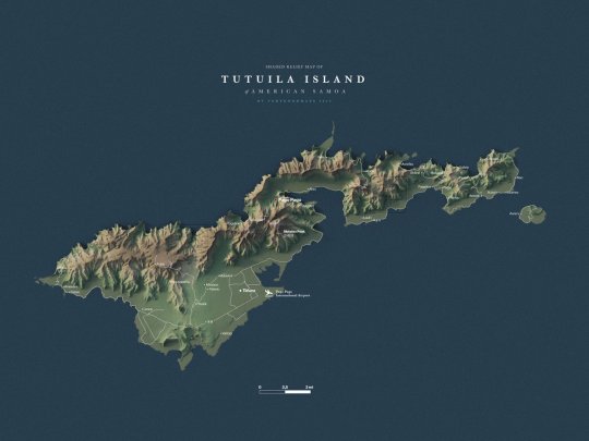
Exaggerated map of Tutuila Island of American Samoa.
by @verygoodmaps
74 notes
·
View notes
Text


#Grumman G-44A Widgeon#NSTU Pago Pago#in the town and plains of Tafuna on the island of Tutuila in American Samoa#taking off from the airport#landing on water#taking off and landing on land#with these islands that are a beautiful landscape in the Pacific Ocean.#The plane#a twin engine from the Second World War#complies and responds in a docile way
0 notes
Photo


Tutuila Island, American Samoa On the islands of American Samoa, rugged volcanic terrain is blanketed with dense tropical rainforest and ringed by dramatic coastlines and coral reefs. The U.S. territory in the South Pacific is made up of five volcanic islands and two coral atolls located 3,500 kilometers (2,200 miles) southwest of Hawaii and 2,600 kilometers (1,600 miles) northeast of New Zealand. This rare cloud-free image of Tutuila, the largest island in the American Samoan chain, was acquired by the Operational Land Imager (OLI) on the Landsat 8 satellite on July 22, 2022. Tutuila Island is the apex of a shield volcano, the majority of which is underwater. The islands of American Samoa were created by hotspot volcanism, similar to the Hawaiian Islands. The Pacific Plate passes over a plume of molten rock rising from the mantle, resulting in a chain of islands and seamounts. The territory is home to the National Park of American Samoa, the only U.S. national park in the Southern Hemisphere. Owing in large part to its remote location, the park was the least-visited U.S. national park in 2022 with 1,887 total visitors, according to the National Park Service. It is distributed across three islands and includes marine areas containing biodiverse coral reefs. Tropical flora and fauna, Samoan culture, archaeological sites, and volcanic landscapes await visitors who make the journey there. Tutuila, as well as the Ofu-Olosega and Taʻū islands to the east, are still considered potentially active. The last eruption on Tutuila dates back 1,700 to 1,400 years, while the most recent volcanic activity along the American Samoan chain has primarily occurred underwater. The hotspot is currently believed to be beneath a seamount east of Taʻū Island. Remnants of past volcanism appear on and around Tutuila. Jutting out from its north shore is Vaiʻava Strait National Natural Landmark. There, wave action has carved away at rocks from the last major volcanic event that formed Tutuila Island, leaving a knife-edge ridge protruding from the ocean (visible in the photograph above). On the tiny island of Aunuʻu, another national natural landmark, relatively young basalt flows are exposed, and the crater rim of a volcanic cone encloses a freshwater marsh. The harbor near Pago Pago sits inside of a collapsed caldera and contains a coral reef community that scientists have surveyed periodically for over 100 years. As the volcanoes of American Samoa cool off from their fiery past, they are becoming denser and slowly sinking. The land subsides even more due to its proximity to the Tonga Trench, which generates large earthquakes. When combined with relative sea level rise, land subsidence can increase the potential frequency and severity of coastal flooding. A team of NASA scientists recently published a study on how to better map ground changes on earthquake-prone islands such as Tutuila. They discovered that supplementing tide gauge and altimetry measurements with data from interferometric synthetic aperture radar (InSAR), which can pierce through clouds and vegetation, could result in a more nuanced and comprehensive map. The study found that Tutuila sank an average of 6 to 9 millimeters per year between late 2015 and mid-2022, compared to 1 to 2 millimeters per year before 2009. That year, an 8.1-magnitude earthquake struck the islands of American Samoa, Samoa, and Tonga. The highest rates of sinking occurred right after the earthquake, especially along the coastlines. NASA Earth Observatory image by Lauren Dauphin, using Landsat data from the U.S. Geological Survey. Photo courtesy of the National Park Service. Story by Lindsey Doermann.
7 notes
·
View notes
Text

US postage stamp, 2000
American Samoa
Scott #3389
Issued: April 17, 2000 - Pago Pago, AS
Quantity: 16,000,000
Designer: Howard Paine
Printed By: Ashton-Potter (USA) Ltd (Lithographed)
American Samoa is a U.S. territory covering 7 South Pacific islands and atolls. Tutuila, the largest island, is home to the capital Pago Pago, whose natural harbor is framed by volcanic peaks including 1,716-ft.-high Rainmaker Mountain. Divided between the islands Tutuila, Ofu and Ta‘ū, the National Park of American Samoa highlights the territory's tropical scenery with rainforests, beaches and reefs.
#stamp#mail#stamps#stamp collecting#postage#usps#stamp collection#postage stamps#philately#philatelic#samoa#american samoa#boat
4 notes
·
View notes
Text

(1/22/1964) The U.S. Navy minesweepers USS Notable (MSO-460), USS Salute (MSO-470) and USS Observer (MSO-461) alongside the internal combustion engine repair ship USS Tutuila (ARG-4), at Charleston, South Carolina (USA) Nara/NHHC
13 notes
·
View notes
Text
AMERICAN SAMOA - PAGO PAGO 5th April 2024
The sun was shining brightly as we arrived in American Samoa.
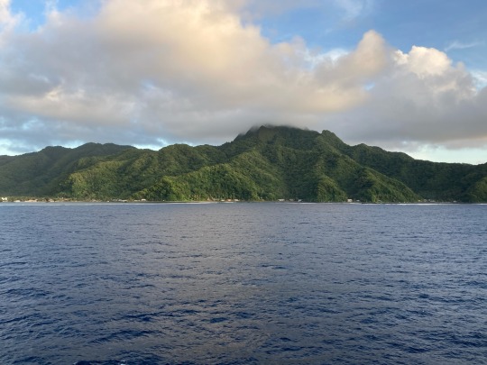
We docked in Pago Pago (pronounced Pahng oh Pahng oh). This was the view as we arrived:
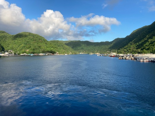
We had arrived on the main island of American Samoa, Tutuila and we took a tour of part of the island. The tour took place in wooden island buses with bench style seats, open windows with no air conditioning and no seatbelts. This is what our bus looked like:

We were taken to places where islanders find great meaning in their lives. The first stop along the coast was the monolithic Fatu-ma-Futi or Flowerpot Rock. There are actually two!
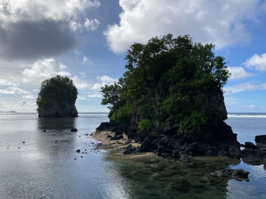
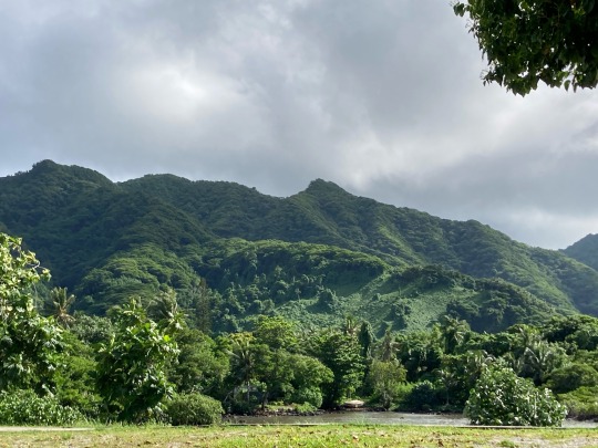
The Flowerpot Rock - the further from the shore - rises straight out of the ocean as though it is guarding the entrance to Pago Pago bay. We continued to travel west. The scenery showed how lush and green the island is:
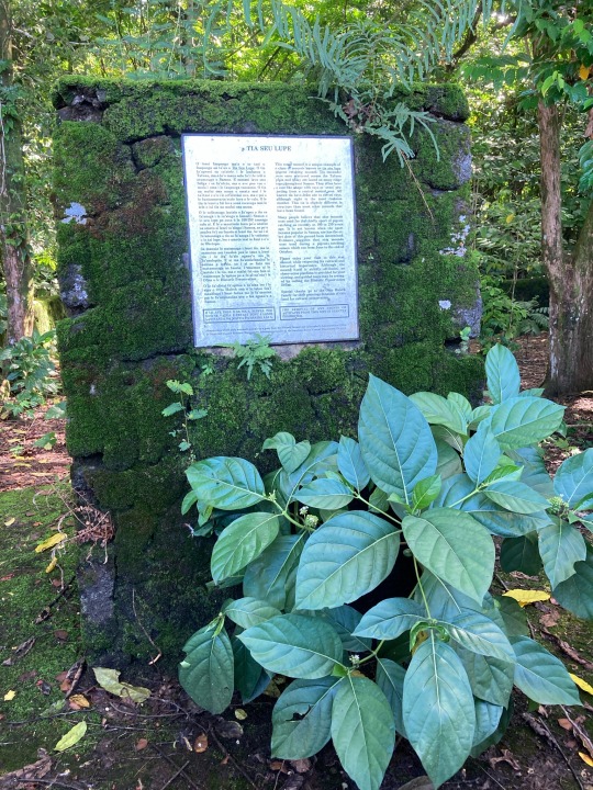
We stopped at a woody site which was of great historical significance to the islanders. Below is a star mound or Tia Seu Lupe. This marks the site where young men would come to hunt for pigeons competing with others. The man who could capture the most birds would then receive the chief ‘s or at least a father’s blessing to marry a young woman.
The Polynesian people of the island live in villages. It was very noticeable that there was an abundance of churches. Often as we were passing through villages, we noticed that many houses have ornate graves marked in the garden as shown here:
Apparently it is Polynesian tradition to bury family members at home. Houses and the land are passed from generation to generation. It was also very noticeable that the villages had a variety of covered pagodas.
Some of these are built by families for their private use, but we also saw many along a beach which are for public use. Apparently each tribal chief has one and each religious minister so that they are a very common sight.
We passed some fantastic scenery along the coastline:
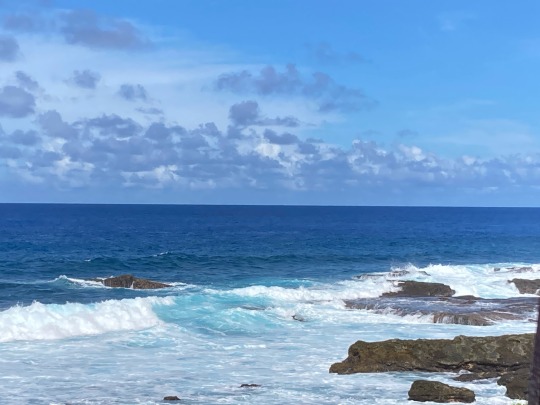
This was near an area which people treat as a water park. Nearby to these jagged rocks were “slider rocks” which are smooth and people enjoy surfing over. Unfortunately not everyone confines themselves to the smooth rocks and it was sobering to see a beach side graveyard for those who have never been found!
We then visited the village of Leone to see an important memorial to those from that village (11) who died in a destructive tsunami in September 2009. Many others were killed in other villages too. The memorial is a sculpture of a “breadfruit” tree as this is a tree that over generations they climb to save themselves from tsunamis. It was very poignant as the memorial had all the photographs of those who died including little children. Here is the memorial:

The coastline at this point showed evidence of earthquake movement with rocks across the bay.
We then returned to Pago Pago and visited the marine conservation centre to learn of their conservation programme within the National Park of American Samoa. They are very proud of what they have achieved.
After a break for lunch we walked into the centre of Pago Pago which in many ways looked similar to the villages we had seen in the morning. It was very hot and humid and as we got back on the ship, there was torrential rain. Before we sailed away we saw several teams of men practicing rowing in the long traditional rowing boats associated with Polynesian culture.
0 notes
Video
youtube
Dr. Joel Klenck, Archaeology Drone, Blunts Point, AS-25-89A, from Feature 008, World War II Pot Boiler, Tutuila, in American Samoa.
0 notes
Text
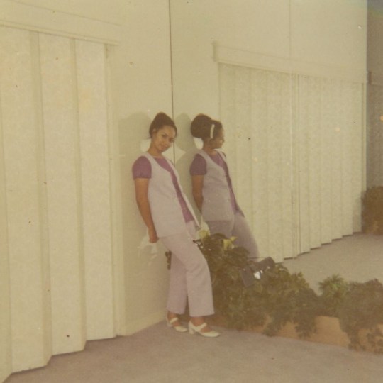
Eneleata "Laka" Henrietta Faalogo nee Manuleleua
B. March 21 1951 in Alao, Tutuila, American Samoa
Victorville, California
#Eneleata Henrietta Faalogo Manuleleua#Laka#Eneleata Henrietta Manuleleua#Eneleata Faalogo#Alao#Tutuila#American Samoa#Victorville#Adelanto#Compton#California#mother#wife#grandmother#beloved aunt and sister#may she rest in peace#<3
14 notes
·
View notes
Photo

Great price on this 2020-P National Park of American Samoa Quarter ONLY: $3.00 National Park of American Samoa is located some 2,600 miles southwest of Hawaii and is one of the most remote in the U.S. National Park System. The site includes sections of three islands—Tutuila, Ta’ū, and Ofu. Almost all of the land area of these volcanic islands—from the mountaintops to the coast—is tropical rainforest. The park’s area totals 13,500 acres, 4,000 of which are underwater. The obverse (heads) design features the familiar image of George Washington by John Flanagan, used on the quarter since 1932. It has been restored to bring out subtle details and the beauty of the original. The reverse (tails) design depicts a Samoan fruit bat mother hanging in a tree with her pup. The image evokes the remarkable care and energy that this species puts into their offspring. The design is intended to promote awareness to the species’ threatened status due to habitat loss and commercial hunting. The National Park of American Samoa is the only park in the United States that is home to the Samoan fruit bat. https://www.thecoinshop.shop/national-park-quarters/2020-p-national-park-of-american-samoa-quarter View MORE National Park Quarters https://www.thecoinshop.shop/national-park-quarters
1 note
·
View note
Text
Terra dallo spazio: Le Samoa Americane
La missione Copernicus Sentinel-2 ci mostra una vista straordinaria dell’isola tropicale di Tutuila, la più grande dell’arcipelago delle Samoa Americane, nell’Oceano Pacifico meridionale.
Le Samoa Americane sono un territorio non incorporato degli Stati Uniti e fanno parte della catena delle Isole Samoa, situata a circa 4000 km a sud-ovest delle Hawaii e a circa 3000 km a nord-ovest della Nuova…

View On WordPress
0 notes
Text

Isola di Pola - Tutuila - Arcipelago delle Isole Samoa
Foto: © Google Street View
0 notes
Text

American Samoa is a U.S. territory covering 7 South Pacific islands and atolls. Tutuila, the largest island, is home to the capital Pago Pago. American Samoa is known for its beautiful natural surroundings. It is home to pristine beaches and reefs. It is a popular destination among the surfers and kite surfers, with strong winds and currents making it ideal for water sports.
0 notes
Last Seen Blogs

hishungryqueen
Untitled

inloveandfinallyso
Just Jez.

avatar-masterofallfandoms
Uncle female

technicalthinker
The World Is Ahead

koldxdragon
KOLD DRAGON