#bc its still occupied land and a settler state
Text
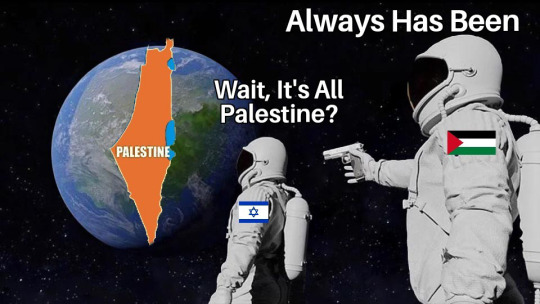
Whenever I see people try to differentiate what is “Israel” and what is the “Palestinian state” I always have a very awkward feeling - which is why I think a lot of people need to reevaluate how they speak about Palestine and Israel, specifically what they define as occupied Palestine.

My father’s family is from a village in Jaffa (the district), which is now part of what most people define as “mainland Israel” or an “undisputed” part of Israel - like that land was acquired legally or ethically and an unequivocal part of what is Israel vs what is considered (at least to some) Palestine (the West Bank & Gaza).
My father’s family had the choice to flee or die and to this day cannot return home to Jaffa. It leaves me with a strange feeling when people discuss a hypothetical “two state solution” as if that land is inarguably Israel and the West Bank and Gaza is inarguably Palestine - my family is not from the West Bank or Gaza, they’re from Jaffa. Proudly Palestinians from Jaffa - they’re not Israeli and never be Israeli, they predate the modern colonial state of Israel.
When people talk about occupied Palestine, they’re usually referring to the 1967 borders and the increasing settlements in the West Bank, when Palestinians talk about occupied Palestine, we’re talking about all of it - every corner of what people define as “mainland Israel” there is a story of Palestinian dispossession - It includes my family and thousands of others.
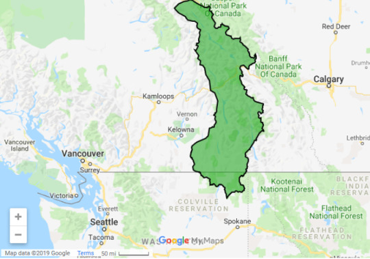
Leaving this map here for people to get an idea of how much destruction of Palestinian life and communities happened in what people see as an “undisputed part of Israel” - there is a reason the Palestinian population here plummeted in 1948.
In short:
#palestine#free palestine#the two state solution isn’t as progressive as a lot of people say#it would ensure Palestinians like me would never get their land back#and palestinians who were able to remain would still be second class citizens#bc its still occupied land and a settler state#settler colonialism#saif talks
22K notes
·
View notes
Text
the sickness i feel every time news of Palestine is shared is truly nothing. i cannot imagine that if this is the measure of helplessness i am experiencing, then what must be the pain of the Palestinians abroad who wait on every second to hear their loved ones are still breathing? the fact that a school in Gaza had ended its academic term bc all the students had been killed and large bloodlines have been wiped out, children have been orphaned and human beings are being rendered a body in a bag for their people to identify.
these have been the people who have tended to every corner of their land, flourishing it with their beloved olive trees, the fruits of which they gathered over, shared laughter or tears over and dedicated hours of toil over. just one aspect of their dear culture that has been under continuous efforts to be abolished by the occupying settlers.
the 7,000+ who have been killed will never remain anonymous, may their aspirations, hopes and the traumas inflicted on their loved ones haunt the western authorities. may there come a time where we understand the desperation reached for such resistance to come about from almost a century of occupation and present the happenings of today with full clarity of the holding powers.
in the meanwhile, we will sustain the hope the Palestinians have protected for their entire lifetime. we will continue to share their plight, their culture and repaint their images to the world. we will continue to shame the “state” of Israel, it’s residents who rejoice in the killings of the indigenous, the hell-damned politicians, the depraved Zionists of the global south who seek out a seperate agenda and those who remain silent as the world enables an atrocious genocide.
im so beyond anger for what the Palestinians are going thru, I only hope u lose meaning in life and Keep Yourself Safe if despite it all, you choose to support Israel
#from the river to the sea palestine will be free#free palestine#free Gaza#free West Bank#fuck Israel
9 notes
·
View notes
Text
A rant against Karen Traviss' understanding of history and her FAQ answers
Did you base the Mandalorians on the Spartans?
<cite>
No. I didn't.
</cite>
Fair enough.
<cite>
I really wish history was taught properly - okay, taught at all - in schools these days, because history is the big storehouse that I plunder for fiction. It breaks my heart to hear from young readers who have no concept even of recent history - the last fifty years - and so can't see the parallels in my books. You don't have to be a historian to read my novels, but you'll get a lot more out of them if you explore history just a little more. Watch a history channel. Read a few books. Visit some museums. Because history is not "then" - it's "now." Everything we experience today is the product of what's happened before.
</cite>
Yeah, I do to. Please, Ms Traviss, go on, read some books. Might do you some good. And don't just trust the history channels. Their ideas about fact-checking differ wildly.
<cite>
But back to Mandos. Not every military society is based on Sparta, strange as that may seem. In fact, the Mandos don't have much in common with the real Spartans at all.
</cite>
You mean apart from the absolute obsession with the military ["Agoge" by Stephen Hodkinson], fearsome reputation ["A Historical Commentary on Thucydides" by David Cartwright], their general-king ["Sparta" by Marcus Niebuhr Tod], the fact that they practically acted as mercenaries (like Clearch/Κλέαρχος), or the hyper-confidence ("the city is well-fortified that has a wall of men instead of brick" [Plutarch, Life of Lycurgus])...
<cite>
A slightly anarchic, non-centralized, fightin' people? Sounded pretty Celtic to me. Since I went down that path, I've learned more about the Celts (especially the Picts), and the more I learn, the more I realise what a dead ringer for Mandos they are. But more of how that happened later...
</cite>
The Celtic people are more than one people, more than one culture. Celtic is a language-family! In the last millennium BC nearly every European ethnic group was in some ways Celtic, and they were not one. Later, after the Germanic tribes (also not one people, or a singular group) moved westwards, the Celtic cultures were still counted in the hundreds. Not only Scotland was Celtic! Nearly all of Western Europe was (apart from the Greek and Phoenician settlers on the Mediterranean coasts).
The word “Celts” was written down for the first time by Greek authors who later also used the word “Galatians”. The Romans called these people “Gauls”, and this word was used to describe a specific area, bordered by the Atlantic Ocean, the Cévennes and the Rhine: “Gaul”. So the Celts, the Galatians and the Gauls were all part of the same Celtic civilisation.
"Celts, a name applied by ancient writers to a population group occupying lands mainly north of the Mediterranean region from Galicia in the west to Galatia in the east [] Their unity is recognizable by common speech and common artistic traditions" [Waldman & Mason 2006]
Mirobrigenses qui Celtici cognominantur. Pliny the Elder, The Natural History; example: C(AIUS) PORCIUS SEVERUS MIROBRIGEN(SIS) CELT(ICUS) -> not just one culture
"Their tribes and groups eventually ranged from the British Isles and northern Spain to as far east as Transylvania, the Black Sea coasts, and Galatia in Anatolia and were in part absorbed into the Roman Empire as Britons, Gauls, Boii, Galatians, and Celtiberians. Linguistically they survive in the modern Celtic speakers of Ireland, Highland Scotland, the Isle of Man, Wales, and Brittany." [Celtic Culture: a historical encyclopedia. by John Koch]
"[] the individual CELTIC COUNTRIES and their languages, []" James, Simon (1999). The Atlantic Celts – Ancient People Or Modern Invention. University of Wisconsin Press.
"All Gaul is divided into three parts, one of which the Belgae live, another in which the Aquitani live, and the third are those who in their own tongue are called Celtae, in our language Galli." [Julius Caesar, De Bello Gallico] <= I had to translate that in school. It's tedious political propaganda.
Read also the Comentarii and maybe the paper "Caesar's perception of Gallic social structures" that can be found in "Celtic Chiefdom, Celtic State," Cambridge University Press.
The Celtic tribes and nations were diverse. They were pretty organized, with an academic system, roads, trade, and laws. They were not anarchic in any way. They were not warriors - they were mostly farmers.
The Celts were first and foremost farmers and livestock breeders
The basic economy of the Celts was mixed farming, and, except in times of unrest, single farmsteads were usual. Owing to the wide variations in terrain and climate, cattle raising was more important than cereal cultivation in some regions.
Suetonius addressing his legionaries said "They are not soldiers—they're not even properly equipped. We've beaten them before." [not entirely sure, but I think that was in Tacitus' Annals]
Regarding the Picts, in particular, which part of their history is "anarchic"? Dál Riata? the Kingdom of Alba? Or are you referring to the warriors that inspired the Hadrian's Wall? Because no one really knows in our days who the fuck they were.
The Picts’ name first appears in 297 AD. That is later.
<cite>
Celts are a good fit with the kind of indomitable, you-can't-kill-'em-off vibe of the Mandos. Reviled by Rome as ignorant savages with no culture or science, and only fit for slaughter or conquest, the Celts were in fact much more civilized than Rome even by modern standards.
</cite>
That's how the Romans looked at pretty much every culture that wasn't Greek, Roman, Phoenician, Egyptian, or from Mesopotamia (read, if you want, anything Roman or Greek about the Skyths, the Huns, Vandals, Garamantes...).
<cite>
They also kicked Roman arse on the battlefield, and were very hard to keep in line, so Rome did what all lying, greedy superpowers do when challenged: they demonized and dehumanized the enemy. (They still used them in their army, of course, but that's only to be expected.)
</cite>
They were hard to keep in line, but they most definitely did not kick Roman arse on the battlefield. Roman arse was kicked along the borders of the Roman Empire, such as the Rhine, the Danube, the Atlas mountains, etc. And mostly by actually badly organized, slightly anarchic groups, such as the Goths or the Huns (BTW the Huns were not a Germanic people, even though early 20th century British propaganda likes to say so). Though they were also decisively stopped by the Parthians. Who were very organized. Ah well.
<cite>
While Rome was still leaving its unwanted babies to die on rubbish dumps - a perfectly acceptable form of family planning to this "civilisation" - and keeping women as chattels devoid of rights, the barbarian Celts had a long-standing legal system that not only gave women what we would think of as equal rights, but also protected the rights of the elderly, children, and the disabled. They had a road network across Europe and worldwide trade long before the Romans ever got their act together. And their science - well, their astronomical calculations were so sophisticated that it takes computers to do the same stuff today.
</cite>
See? You even say yourself that they weren't actually anarchic. Also you're not completely right:
1. women (of most Celtic cultures, with one notable exception being the Irish) were not allowed to become druids, e.g. scientists, physicians, priests, or any other kind of academics, so they did not have equal rights. Also, as in other Indo-European systems, the family was patriarchal.
2. the roads they had were more like paths, and did not span the entirety of Europe; the old roads that are still in use are nearly all of them Roman. Had the Celtic inhabitants of Gallia or Britannia built comparable roads, why would the Romans have invested in building a new system on top?
3. world-wide? Yeah, right. They traded with those who traded with others and so were able to trade with most of southern Eurasia and northern Africa, as well as few northern parts (Balticum, Rus), but that's (surprise) not the whole world.
4. most people use computers for those calculations you mention because its easier. It's not necessary. I can do those calculations - give me some time to study astronomy (I'm a math major, not physics) and some pencils and paper.
5. and - I nearly forgot - the kids didn't die. That was a polite fiction. The harsh truth is that most Roman slaves were Romans...
<cite>
So - not barbarians. Just a threat to the empire, a culture that wouldn't let the Pax Romana roll over it without a fight. (Except the French tribes, who did roll over, and were regarded by the Germanic Celts [...])
</cite>
WTF Germanic Celts? What are you smoking, woman? Isn't it enough that you put every culture speaking a language from the Celtic family in one pot and act as if they were one people, now you have to mix in a different language-family as well? Shall we continue that trend? What about the Mongolian Celts, are they, too, proof that the Celts were badass warriors?
I think at this point I just lost all leftover trust in your so-called knowledge.
<cite>
[...] as being as bad as the Romans. Suck on that, Asterix...
</cite>
Asterix was definitely a Celt, and unlike the British Celts, he was not a citizen of the Roman Empire.
<cite>
Broad brush-stroke time; Celts were not a centralized society but more a network of townships and tribes, a loose alliance of clans who had their own internal spats, but when faced with some uppity outsider would come together to drive off the common threat.
</cite>
They might have tried, but they didn't. The first and only time a Celtic people really managed to drive off some uppity outsider would be 1922 following the Anglo-Irish Treaty of 1921*. The fact that France, Spain, Portugal speak Romance languages and the British (or Irish) Isles nearly uniformly speak English should be proof enough.
*Unless you count Asterix.
<cite>
You couldn't defeat them by cutting off the head. There was no head to cut off.
</cite>
You mean unlike Boudica and Vercingetorix. Oh wait.
Tacitus, in his Annals, said that Boudica's last fight cost 80,000 Britons and 400 Romans their lives. He was probably exaggerating. But it definitely stopped much of the British resistance in its tracks.
<cite>
To the centralized, formal, rather bureaucratic Romans, for whom the city of Rome was the focus of the whole empire, this was a big does-not-compute. The Celts were everything they didn't understand. And we fear what we don't understand, and we kill what we fear.
</cite>
While that is totally true, it's also completely off the mark. The Romans demonized the druids, not every Celt, and they were afraid of what was basically an academic network. That had nothing to do with war.
<cite>
Anyway, Mandos....once I took a single concept - in this case, the idea of clans that operated on a loose alliance system, like the Celts - the rest grew organically. I didn't plan it out in detail from the start.
</cite>
That's really obvious. Maybe looking at some numbers and remembering that you weren't planning a small, local, rural, medieval community would have helped, too. I mean lets have a look at, say, Scotland (since you specifically mentioned the Picts): they still have less than 6 mio. people all together, and that's today. Mandalore is a sector. A sector of Outer Space with at least 2000 inhabited planets. How do you think that translates? It doesn't.
<cite>
I just asked myself what a culture of nomadic warriors would value, how they would need to operate to survive, and it all grew inexorably by logical steps. The fact that Mandos ended up as very much like the Celts is proof that the technique of evolving a character or species - find the niche, then work out what fits it - works every time. It creates something very realistic, because that's how real people and real societies develop.
</cite>
Celtic people were usually not nomadic! And, once again, non of them were predominantly warriors! It's really hard to be a nomadic farmer. I believe the biggest mistake you made, Ms Traviss, is mixing up the Iron Age (and earlier) tribes that did indeed sack Rome and parts of Greece, and that one day would become the people the Romans conquered. And apart from the Picts they really were conquered.
<cite>
So all I can say about Mandos and Spartans is that the average Mando would probably tell a Spartan to go and put some clothes on, and stop looking like such a big jessie.
</cite>
I'd really like to see a Mando – or anyone – wearing full plate without modern or Star Wars technology in Greece. Happy heatstroke. There is a reason they didn't wear a lot (look up the Battle of Hattîn, where crusaders who didn't wear full helmets and wore chainmail* still suffered badly from heat exhaustion). [Nicolle, David (1993), Hattin 1187: Saladin's Greatest Victory]
*chainmail apparently can work like a heatsink
CONCLUSION
You're wrong.
And I felt offended by your FAQ answers.
QUESTION
You're English. You're from England. A group - a nation - that was historically so warlike and so successful that by now we all speak English. A nation that definitely kicked arse against any Celtic nation trying to go against them (until 1921, and they really tried anyway). A nation that had arguably the largest Empire in history. A nation that still is barbaric and warlike enough that a lost football game has people honestly fearing for their lives.
Also, a Germanic group, since you seem to have trouble keeping language-families and cultures apart. If we were to talk about the family, we could add on the current most aggressively attacking nation (USA) plus the former most aggressively attacking nations (the second and third German Reich), also the people who killed off the Roman Empire for good (the Goths and Visigoth), the original berserkers (the Vikings) and claim at the very least the start of BOTH WORLD WARS.
Why did you look further?
Some other sources:
Histoire de la vie privée by Georges Duby and Philippe Ariès, the first book (about the antiquity) I read it translated, my French is ... bad to non-existent
The Day of the Barbarians: The Battle That Led to the Fall of the Roman Empire (about the Huns) by Alessandro Barbero
If you speak Dutch or German, you might try
Helmut Birkhan: Kelten. Versuch einer Gesamtdarstellung ihrer Kultur, Verlag der Österreichischen Akademie der Wissenschaften, Wien
Janssens, Ugo, De Oude Belgen. Geschiedenis, leefgewoontes, mythe en werkelijkheid van de Keltische stammen. Uitgeverij The House of Books
DISCLAIMER
I’m angry and I wrote this down in one session and thus probably made some mistakes. I’m sorry. Or maybe I’m not sorry. I’m still angry. She can’t know who reads her FAQ and at least two of her answers (on her professional website) were offensive to the reader.
#history#england#scotland#ancient celts#roman empire#mandalorians#sparta#proud warrior race#shitty research#rant#me ranting#fuck this#karen traviss
81 notes
·
View notes
Text
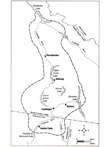
Sinixt people, declared “extinct” by Canada. Traditional land partitioned by the Canada-US political border. Province of British Columbia continues to argue that Sinixt people have no land rights. Sinixt people continue to win appeals against the province, culminating in scheduled October 2020 federal supreme court arguments.
Update (23 April 2021):


Update (October 2020):

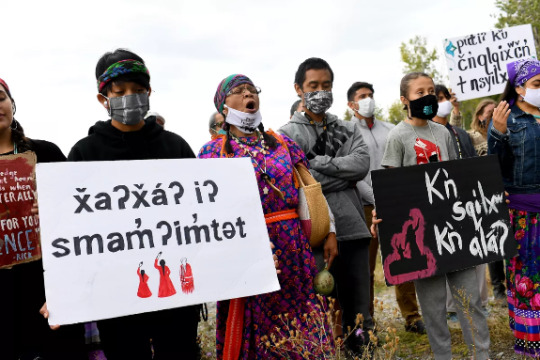
[Caption:] Virginia Redstar, center, with the River Warrior Society sings as she joins Colville Confederated Tribe members and supporters at the Boundary-Waneta Border Crossing in support of Rick Desautel's case in the Canadian Supreme court arguing for the Sinixt peoples' right to hunt traditional lands in Canada on Thursday, October 8, 2020, near Northport, Wash. [...] [T]o challenge a Canadian declaration 60-years-ago that the Sinixt people were extinct. [Photo by Tyler Tjomsland for The Spokesman-Review, October 2020.]
They got as close they could on Thursday afternoon [8 October 2020]. In a caravan of cars and trucks, they travelled north of Northport, to a bluff overlooking both the Columbia River and the Boundary-Waneta Border Crossing that wouldn’t let them – or anyone else from the United States – cross into Canada. Some 2,400 miles away, in Ottawa, Ontario, Mark Underhill, Desautel’s lawyer, argued a case in the Supreme Court of Canada that began 10 years ago this month. Many of them belong to the Confederated Tribe of the Colville Indians, and a number are descendants of the Sinixt. That tribe’s members once moved freely across this landscape, far into what is now British Columbia, into a country that considers them officially extinct. [...] While Her Majesty the Queen v. Richard Lee Desautel is narrowly about whether some 3,000 people have a right to hunt in a relatively remote part of British Columbia, the implications for not only the Lakes Tribe but also other Indigenous people with historical connections to Canada could be far-reaching. [...] [T]he Crown has been vested in appealing the case because “they have taken the view that this would be precedent setting and would set the stage for other tribes.” In its filings to the Supreme Court, the Crown’s lawyers made just that argument, claiming that “affirming that Indigenous groups located in the US are ‘aboriginal peoples of Canada’ enjoying a constitutionally protected Aboriginal right to hunt in Canada would mean that such groups may, in principle, hold constitutionally protected Aboriginal title to Canadian soil, too.” That means “not only site-specific rights like the right to hunt, but also rights to the land itself,” the filings state. [...] That could mean the Canadian government will have to consult with the Lakes Tribe on hydropower and pipeline projects, for example. And it may mean even more: that they have rights to land in Canada. [Text excerpt from: Ted McDermott. “ We’re still here’: Colville tribal member’s long battle against declaration of extinction reaches Canadian Supreme Court.” The Spokesman-Review. 11 October 2020.]


Update from May 2020: Despite BC provincial government objections, the Sinixt people are close to officially being considered “not extinct” by the Canadian federal government. The Sinixt vs. British Columbia case, also supported by the Colville Tribes, was scheduled to be heard by Canada’s highest court on 12 May 2020. But the Supreme Court of Canada has postponed the case until fall session, October 2020.
A CBC press release from 2 May 2020: The sn̓ʕay̓ckstx or Lakes Tribe is one of twelve represented by the CCT [Confederated Tribes of the Colville Reservation, in Washington State]. For thousands of years the sn̓ʕay̓ckstx occupied a sizable territory in what is now British Columbia, and moved back and forth across what they view as an artificial boundary between the United States (U.S.) and Canada. When the border was established in 1846, sn̓ʕay̓ckstx people on the ‘U.S. side’ encountered increasing difficulties in exercising their rights north of the border [...]. Ultimately, [the] sn̓ʕay̓ckstx [...] were declared ‘extinct’ in Canada in 1956. The Court of Appeal affirmed that the rights of the sn̓ʕay̓ckstx endure despite this displacement, stating: The latest Court of Appeal ruling sided with the Sinixt and against the BC provincial government, stating: “Imposing a requirement that Indigenous peoples may only hold Aboriginal rights in Canada if they occupy the same geographical area in which their ancestors exercised those rights, ignores the Aboriginal perspective [and] the realities of colonization [...].”
Update from January 2020: BC provincial government continues to lose during appeals, but the case is going to federal Supreme Court. The Sinixt case will be heard in May 2020. Excerpt: “Sinixt traditional territory straddles the U.S.-Canada border. The federal government declared the Sinixt extinct in Canada in 1956. As a result, the Sinixt, most of whom live in Washington state, have no rights, status, or citizenship north of the border. But the court decisions in the Desautel case state the Sinixt are legitimately aboriginal people under the Constitution of Canada. In response to each court defeat, the provincial government [...] appealed to a higher court only to lose each time. If the Supreme Court of Canada court sides with the Sinixt, their extinct status could be overturned.” [From: Metcalfe. “Supreme Court of Canada agrees to hear B.C.’s appeal in Kootenay aboriginal rights case.”” Nelson Star. 29 December 2019.]
Original post:
Map of traditional Sinixt land. [From Sinixt Nation online portal.]
As long as we’re talking about southern mountain caribou extinction and the traditional land of the Sinixt people in the inland temperate rainforest zone: Since May 2019, multiple appeals courts have sided with the Sinixt and against the BC provincial government. But the case also paved the way for another historically significant change: the Canadian government declared the Sinixt people “extinct” in 1956, and the outcome of this case may have laid the legal groundwork for formal recognition of the Sinixt people in Canada.
The Canadian government declared the Sinixt people “extinct” in 1956, despite the relatively large area of land inhabited by Sinixt people and despite Sinixt people living as registered members of US confederated tribes and living among other Canadian First Nations. [The Sinixt are sometimes referred to in settler-colonial texts as the “Lakes tribe.”] This current legal situation began around October 2010, when Rick Desautel - a member of Lakes Tribe of the Colville Confederated Tribes, in northeastern Washington near Spokane - harvested an elk near Castelgar in British Columbia. Since he was technically a US citizen, BC officials charged him with hunting without a license and hunting without being a resident. Desautel argues that the elk hunt was permissable because it occurred on traditional Sinixt land - a land which crosses the US-Canada border.
Map of traditional Sinixt land, from Sinixt Nation online portal:
Excerpt from Feliks Banel, for My Northwest, 8 May 2019: The decision last week by the B.C. Court of Appeal to uphold this decision is another significant legal victory [...]. More importantly for other Sinixt people, it may also mean that the Sinixt First Nation (also known as the Arrow Lakes Band) – which was deemed extinct by the Canadian government in 1956 on dubious contentions that the Sinixt people had dispersed and moved away from their homelands – might be officially recognized again.
Update from August 2019: The Sinixt continue to win the case, but now the case might be going to the federal Supreme Court of Canada because the BC provincial government is appealing the decision.
Excerpt from Bill Metcalfe, for Nelson Star, 29 December 2019: “The Supreme Court of Canada agreed this year [2019] to hear the provincial government’s appeal of a Sinixt hunting case that has been in the news for several years. The result will have major implications for the Sinixt and for aboriginal rights across the country. Successive judges in the B.C. Provincial Court, B.C. Supreme Court and B.C. Court of Appeal have all ruled that Richard Desautel, a Sinixt man living in Washington state, had an aboriginal right to hunt an elk […] But the court decisions in the Desautel case state the Sinixt are legitimately aboriginal people under the Constitution of Canada. [...] If the Supreme Court of Canada court sides with the Sinixt, their extinct status could be overturned, according to their lawyer, Mark Underhill. In fact, he says it has already been overturned.”

5K notes
·
View notes
Text
The Big RWBY explainer:
OK So I’m going to try to take the lore and worldbuilding in RWBY and make it more clear because the writers in the beginning weren’t great at explaining the technical fantasy stuff in RWBY and I’m going to try to make a concise post that doesn’t spoil much. Although I’ll say right now spoiler warning for World of Remnant and some things in RWBY volumes 1&2.
Table of Contents:
1Geography, Kingdoms, the world, and political climate
2 history, faunus, and the mundane magic-y bits
3 grimm and huntsmen
4 meta stuff
1 The world:
So the land of RWBY is called the World of Remnant, that the “earth” that RWBY is in.
It contains 4 “kingdoms” along with settlements outside of those kingdoms. I use kingdom in quotes bc kingdom is a bit of a misnomer because they’re more like city-states and don’t occupy too much land on their respective continents. Each kingdom is on a different continent.
One more thing: yes the moon is shattered (It wasn’t in the Red trailer because I think they added it later, but it is shattered) (they explain why later, but I’m not going to)
The Kingdom of Vale:
This kingdom contains the huntsman schools
Signal: which is like a school for younger kids, we know that Yang graduated from Signal to go to Beacon
Beacon: the main school where the show takes place, the first year students start (usually) at age 17 (however they haven’t said how many years of school a huntsman has to go through until they graduate). It is located decently close to the city of Vale ( the only surviving city of the kingdom).
The city of Vale has a kind of contemporary/fantasy America feel to it (more in that it doesn’t scream any other culture than that it is trying to be American).
The Kingdom of Mistral:
This kingdom has the huntsman school Haven which is a school that functions like Beacon and Sanctum which functions like Signal.
Mistral is on the largest continent and is said to frequently have bandit problems. They have a very east Asian feel to the kingdom in its architecture, clothes, and food.
This kingdom has 2 cities Mistral and Argus. Haven is in Mistral (the city) and Sanctum is in Argus.
Mistral has a bit of a tense relationship with the next kingdom, Atlas because of the complicated agreement with Argus. (If i say anymore it's a vol 6 spoiler so I’ll stop here).
The Kingdom of Atlas:
The kingdom of Atlas has 2 cities, Atlas and Mantle. This is the only kingdom that has a military ( the other 3 don’t) and it also has its huntsman academies function as military academies. It’s very European in design, imperial European . This kingdom is on the tipping point of starting a war, and has peace on a razor’s edge. They have 1 known huntsman academy in Atlas.
Atlas used to be called the kingdom of Mantle, because Mantle used to be its capital ( look in the history section for an explanation).
The Kingdom of Vacuo:
This is the only kingdom that hasn’t shown up in the show yet, but it’s in the books. It’s a desert that has mostly migrating settlements. It’s government is a bit of a sham and the huntsman academy, Shade, is really in charge of keeping the peace. Atlas extracted many resources from Vacuo in the past in order to build its own kingdom, turning a lush jungle into a desert. More of a dangerous and unsafe place than Vale.
Other non kingdom places of note:
Vytal: An island off the coast of Vale, the treaty to end the Great War (see below) was signed here, and every 2 years the Vytal Festival takes place, a festival where cultures come together. Also students from the 4 elite huntsman schools (Beacon, Haven, Atlas,Shade) come together for a fun tournament.
Menagerie: The island was given to the faunus (see below) as a sort of homeland for their contributions during The Great War, however many faunus see this as a slap in the face because the land is 2/3rds desert, leading to overcrowding in the inhabitable areas.
Patch: A small island off the coast of Vale that Ruby and Yang live on. It is also where Signal is.
2 The History:
So this is going to talk about the history that the average citizen of Remnant would know and not the cool protagonist knowledge that team RWBY gets later.
The Great War:
About 80 years before the start of the show the most memorable war apparently in the history of Remnant took place. The war starts like this: Political tensions were high, Vale and Vacuo were getting uncomfortable about Mantle and Mistral’s closeness, until one day Mantle decided to ban artistic expression and self expression. Mistral followed along as to not lose this alliance. Vale already wasn’t happy about how Mantle and Mistral treated their citizens, slavery included in that. But it wasn't until settlers from Mistral started fighting settlers from Vale on an unoccupied island that an actual war began. The TL;DR is that Mantle's ago was wounded so they still had a military, the other 3 kingdoms disbanded their militaries and set up huntsman academies, the in- canon reason everyone has a color name is because of the war (more on that in the meta section), this is the reason the Vytal festival exists, there is peace, they banned slavery, and the faunus rights movement starts soon after the war.
The Faunus:
The faunus are a fantasy race of people that have an animal characteristic, like ears, tails, teeth, antlers, w/e
So the faunus are discriminated heavily (At least in the past, the only place in show present where there is still blatant discrimination would be Atlas/Mantle). The most common type of faunus would be mammal faunus (ex. cats, dogs, deer,) Some faunus are able to hide themselves in order to blend in with humans. The only faunus rights group mentioned in the show is the White Fang. They started off doing non violent actions like boycotts, but when their leader stepped down they became increasingly more violent. (This is actually explained decently well in the show so I’m going to leave it here because I’m trying to give the least amount of spoilers)
Aura:
Aura is a projection of one's soul. It sort of acts like a protective bubble, and functions like HP in a video game, you can’t get permanently injured (cuts, dismemberment ,die) if you have your aura up (the exception is in the white trailer because I don’t think they solidified this rule yet for the trailer). Your aura color is unique to the individual (or at least our main cast) and that is, essentially, your soul’s color. Not everyone has activated their aura (civilians and background characters) but if you have you may be able to access your Semblance.
Semblance:
It’s like your own personal superpower. Think like the X-men. Anyone can have any type of Semblance, but there are a few common varieties. Such as augmenters, cloners, and emitters, or absorbers. (these are all names I’ve come up with, but they kinda help make sense because RWBY has a lot of characters so you can’t remember everyones’ Semblances). Augmenters would be Semblances that change how much your body can do, like a speed enhancing Semblance. Cloners would be a Semblance that allows you to make copies of yourself ( or others). Emitters would be a Semblance that allows you to change the physical space, or someone's perception of physical space (ex. An illusion Semblance or a Magneto-style Semblance). And an absorber would be a Semblance that allowed you to absorb some kind of energy and redirect or use it in some way (like if there was a Semblance that allowed you to absorb damage and shoot it back at the person who fired). Again these are labels that I use and aren’t official, they just make it easier for me to remember because these are the most common types. (a quick clarification because I wasn’t sure if I said this already, but faunus have souls, they are able to produce an aura, and they can have a semblance, they are people. Aura = soul = people)
Dust:
So Aura and Semblances aren’t the only magic-y thing common in Remnant. The last thing on our list is Dust. Dust are magic crystals that contain elemental abilities( like how in the White trailer Weiss is able to strike the ground and summon ice). In RWBY these are most commonly seen as bright crystals and powder, but also are incorporated into the bullets the characters use (Any time a character shoots not a grenade or rocket launcher and there’s an explosion they were likely using combustion dust). This is most easily seen with Weiss because of how she uses dust. Dust can also be manipulated to make forms not found in nature (like fire or ice) into something like hard light dust (or it can make a force field). Dust can also be used in tandem with semblances (for example if there’s a cloner they may be able to make an exploding clone). It is also used for non combative reasons, such as running cars, trains, planes. Dust functions as the main source of power on Remnant everything from homes being heated with fire dust to machines being powered by electricity Dust. (The reason I refer to Aura, Semblances, and Dust as “magic-y” is because RWBY is very specific in saything they aren’t magic).
4 Grimm and Huntsman:
Grimm:
So, grimm are monsters made of darkness and shadow. They are basically just mindless hordes. They don’t eat, they aren’t animals, and they don’t really do much beyond wander around looking for humans (and faunus) to kill. They are drawn to negative human emotions, like fear, anger , and sadness. (that’s why Mistral and Mantle wanted to take away people’s expression, so they wouldn’t accidentally attract grimm(still not right tho)). Grimm are hunted and killed by Huntsman and Huntresses, people trained and taught how to fight and that’s their job. But the people of Remnant don’t know much about the origins or biology of grimm (I honestly think it's kinda like a virus thing where they aren’t alive but really look it and all they do is kill living things) Because they disappear after “death”.
Huntsman and huntresses:
So, as I’ve kinda halfway explained throughout this thing; Huntsman and Huntresses are people who chose to (it's a trained profession) go out there and fight grimm, along with bandits and murderers or whatever (basically Remnant’s superheroes). They are trained at Huntsman academies, (listed above; Beacon, Haven, Atlas’, and Shade). They use their Aura and (usually) have access to a Semblance. Use Dust (usually) and are all around good people fighting for what's right (generally).
5 Meta Stuff:
Alright this is where I put all of the stuff that isn’t canon to the world of Remnant, but is important to understand the story.
So, there are a few fairy tales that exist in Remnant that will come up in the story (You can easily find these online, RT published a book of them) One of them is a story about the gods of Remnant (the story itself doesn’t matter for my point) there are 2 of them and they are called The Brothers’ Grimm (Like the fairy tale writers) this is because every (important) character is an allusion to a fairy tale, mythological, or legendary figure.
For example, Ruby is Little Red Riding Hood. Some of them are obvious (ex Ruby) and some are not.
(I’ve noticed that there’s kind of a pattern; There’s characters who are just aesthetic allusions (ex Ruby) characters who are story allusions (spoiler Penny is Pinnochio), or characters who are both (Weiss and Blake), characters who have their own allusion, but pick up another due to their relationship with another character (Qrow and Raven), and characters who don’t look like they have an allusion, but theirs is revealed as a plot twist (I’m not giving an example here).
There’s stuff I’ve leaving out here that CRWBY doesn’t explain well right out of the gate, but this stuff is necessary in order to clearly understand at least volumes 1-2.
#rwby#rwby spoiler#rwby meta#rwby guide#rwby thoughts#fuck y'all this was 6 pages long in google docs#and i wrote this at 3 AM
9 notes
·
View notes
Text
LITERATURE
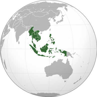
SOUTHEAST ASIA
Southeast Asia or Southeastern Asia is the southeastern subregion of Asia, Southeast Asia is composed of eleven countries of impressive diversity in religion, culture and history: Brunei, Burma (Myanmar), Cambodia, Timor-Leste, Indonesia, Laos, Malaysia, the Philippines, Singapore, Thailand and Vietnam.
The earliest Homo sapiens presence in Mainland Southeast Asia can be traced back to fifty thousand years ago and to at least fourty thousand years ago in Maritime Southeast Asia. As early as ten thousand years ago, Hoabinhian settlers had developed a tradition and culture of distinct artefact and tool production. During the Neolithic period, Austroasiatic peoples populated Indochina via land routes and sea-borne Austronesian immigrants preferably settled in Maritime Southeast Asia. The earliest agricultural societies that cultivated millet and wet-rice emerged around 1700 BCE in the lowlands and river floodplains of Indochina
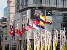
"ASEAN members' flags in Jakarta. Modern Southeast Asia has been characterised by high economic growth by most countries and closer regional integration. Indonesia, Malaysia, the Philippines, Singapore and Thailand have traditionally experienced high growth and are commonly recognised as the more developed countries of the region. As of late, Vietnam too had been experiencing an economic boom. However, Myanmar, Cambodia, Laos and the newly independent East Timor are still lagging economically."
According to my research, it says that "On 8 August 1967, the Association of Southeast Asian Nations (ASEAN) was founded by Thailand, Indonesia, Malaysia, Singapore and the Philippines. Since Cambodian admission into the union in 1999, East Timor is the only Southeast Asian country that is not part of ASEAN, although plans are under way for eventual membership. The association aims to enhance co-operation among Southeast Asian community. ASEAN Free Trade Area has been established to encourage greater trade among ASEAN members. ASEAN has also been a front runner in greater integration of Asia-Pacific region through East Asia Summits." This is according to wikipedia.
The notable literary genres in southeast asia are;
Traditional Oral Literature- Folktales, Proverbs, Riddles, legends.
Religious Narratives and Literature- Buddhist Codes and verses, Jataka Tales.
Narrative Poetry - Epic Stories.
One of the example is The legend of Princess Kinnaree Manorah by Anthony Phanvilay is an example of south east asian myths. This story of Manorah has inspired a dance form known as the Manorah Buchayan.
EAST ASIA
East Asia is the eastern region of Asia, which is defined in both geographical and ethno-cultural terms
East Asia is politically divided into eight countries and regions: China, Mongolia, North Korea, South Korea, Japan, Hong Kong, Taiwan, and Macau.
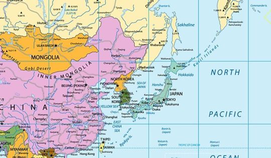
East Asia, one of the five regions of Asia, is located east of Central Asia, with its eastern border running along the East China Sea. East Asia is politically divided into eight countries and regions: China, Mongolia, North Korea, South Korea, Japan, Hong Kong, Taiwan, and Macau. This region covers a total area of 4,571,092 square miles and has a population size of more than 1.641 billion, which represents 22% of the global population and 38% of Asia's total population. Many residents of East Asia are concentrated in major metropolitan areas such as Beijing and Tokyo.
The geography of East Asia is varied depending on the zone. The inner continental area experiences a temperate climate, while Mongolia is covered by the arid Gobi desert. China, the largest country in the region, is home to both mountains and plateaus, while Japan is characterized by thousands of islands and coastlines. Today, East Asia is believed to have some of the most advanced technologies in the world, which fosters economic development.
East Asian literature includes:
Chinese literature
Japanese literature
Korean literature
Mongolian literature
Taiwanese literature
EXAMPLE OF THEIR ART
Chinese art is visual art that, whether ancient or modern, originated in or is practiced in China or by Chinese artists. The Chinese art in the Republic of China (Taiwan) and that of overseas Chinese can also be considered part of Chinese art where it is based in or draws on Chinese heritage and Chinese culture. Early "stone age art" dates back to 10,000 BC, mostly consisting of simple pottery and sculptures. After this early period Chinese art, like Chinese history, is typically classified by the succession of ruling dynasties of Chinese emperors, most of which lasted several hundred years.
SOUTH AND WEST ASIA
South and West Asia is also identified by its economic potential and growth. The region is valued for its supply of low cost goods, services and skilled labour to the global economy but at the same time, it is notorious for the payment of low wages, appalling working conditions and trafficking of labour. This changing economic landscape has had a corresponding impact on the social and geographic fabric of the region.
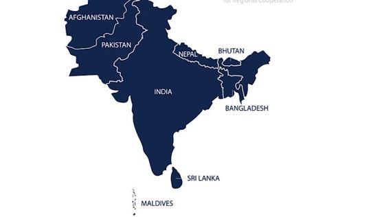
South Asia has a peninsula-like shape that is bordered by three bodies of water: the Indian Ocean to the south, the Bay of Bengal to the east, and the Arabian Sea to the west. The region includes Indian subcontinent and surrounding countries. South Asia is politically divided into eight autonomous countries: Sri Lanka, Bangladesh, India, Afghanistan, Pakistan, Bhutan, Nepal, and the Maldives. The region covers a total area of roughly two million square miles and has a population size of more than 1.74 billion, which is nearly a quarter of the global population. Additionally, South Asia has the distinction of being the most densely populated area in the world.
West Asia is located in the area between Central Asia and Africa, south of Eastern Europe. The majority of the region is often referred to as the Middle East, although it geographically excludes the mainland of Egypt (which is culturally considered a Middle Eastern country). West Asia is politically divided into 19 states: Georgia, Armenia, Azerbaijan, Turkey, Cyprus, Syria, Lebanon, Israel, Palestine, Jordan, Iraq, Iran, Kuwait, Bahrain, Qatar, Saudi Arabia, United Arab Emirates, Oman, and Yemen. It also includes the Sinai Peninsula of Egypt. The region covers a total area of around 2.415 million square miles and has a population size of 313.428 million.
A large area of the region is covered by an arid desert environment. However, West Asia does have several points of access to large bodies of water, including the Black Sea, Persian Gulf, Arabian Sea, Red Sea, Caspian Sea, Mediterranean Sea, and the Aegean Sea.

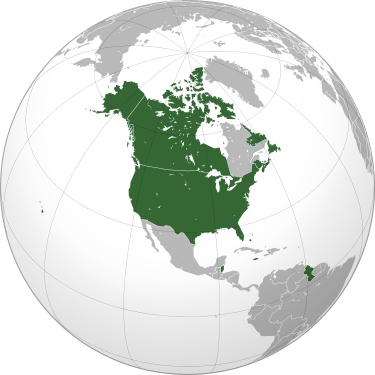
Anglo-Americans
are people who are English-speaking inhabitants of Anglo-America. It typically refers to the nations and ethnic groups in the Americas that speak English as a native language who comprise the majority of people who speak English as a first language.
Languages
English (American, Canadian, Jamaican, Trinidadian, Guyanese, Belizean, Bajan, Bahamian, Vincentian, Grenadian, Anguillian, Montserrat, Antiguan and Barbudan, Saint Kittian and Nevisian, and Falkland Islands)

Europe
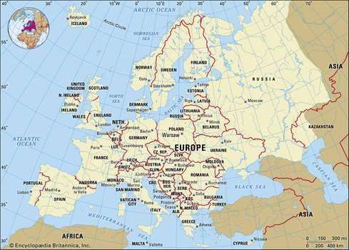
second smallest of the world’s continents, composed of the westward-projecting peninsulas of Eurasia (the great landmass that it shares with Asia) and occupying nearly one-fifteenth of the world’s total land area.
AFRICA
Africa is the world's hottest continent with deserts and drylands covering 60% of land surface area (e.g. Kalahari, Sahara and Namib). Africa is the world's second driest continent (after Australia). Africa has approximately 30% of the earth's remaining mineral resources. Africa is also the world's second-largest and second-most populous continent, after Asia in both cases.
All in all, there are 54 sovereign African countries and two disputed areas, namely Somaliland and Western Sahara (see the list of African countries below).

African literature
the body of traditional oral and written literatures in Afro-Asiatic and African languages together with works written by Africans in European languages. Traditional written literature, which is limited to a smaller geographic area than is oral literature, is most characteristic of those sub-Saharan cultures that have participated in the cultures of the Mediterranean. In particular, there are written literatures in both Hausa and Arabic, created by the scholars of what is now northern Nigeria, and the Somali people have produced a traditional written literature.
LATIN AMERICA
Latin America is a group of countries and dependencies in the Western Hemisphere where Romance languages such as Spanish, Portuguese, and French are predominantly spoken.
The region consists of people who speak Spanish, Portuguese and French. These languages (together with Italian and Romanian) developed from Latin during the days of the Roman Empire and the Europeans who speak them are sometimes called 'Latin' people. Hence the term Latin America.
LATIN AMERICA LITERATURE
Latin American literature refers to written and oral works created by authors in parts of North America, South America, and the Caribbean. Latin American authors usually write in Spanish, Portuguese, English, or a language native to their specific country.
Credits to google and wikipedia for the images and some infos!
by; ELLAINE HIPOLITO
6 notes
·
View notes
Text
Cove Orchard to PDX shuttle airport
Cove Orchard to PDX shuttle airport
$ 80 00
Royal Junction +
Zip code: ———
Reservation Now
http://beavertonairporter.com/ +1 (503) 760 6565 PDX shuttle airport
Yarmouth is a town in Cumberland County, Maine, located twelve miles north of the state’s largest city, Portland. The town was settled in 1636 and incorporated in 1849. Its population was 8,349 in the 2010 census. As of 2015’s estimation, this is about 0.6% of Maine’s total population. Five islands (most notably Cousins Island and Littlejohn Island) are part of the town.
Yarmouth is part of the Portland–South Portland–Biddeford Metropolitan Statistical Area.
The town’s proximity to the Atlantic Ocean, and its location on the banks of the Royal River, which empties into Casco Bay less than a mile away, means it is a prime location as a harbor. Ships were built in the harbor mainly between 1818 and the 1870s, at which point demand declined dramatically. Meanwhile, the Royal River’s four waterfalls within Yarmouth, whose Main Street sits about 80 feet above sea level, resulted in the foundation of almost sixty mills between 1674 and 1931.
http://beavertonairporter.com/ +1 (503) 760 6565 PDX shuttle airport
The annual Yarmouth Clam Festival attracts around 120,000 people (around fourteen times its population) over the course of the three-day weekend.
Today, Yarmouth is a popular dining destination, with (as of February 2019) fourteen sit-down restaurants. This equates to an average of just over one restaurant per square mile of land area.
The town is accessed via two exits (15 and 17) on each side of Interstate 295. U.S. Route 1 also passes through the town to the west of I-295.
It has been designated a Tree City USA community every year since 1979. 40 years ago.
http://beavertonairporter.com/ +1 (503) 760 6565 PDX shuttle airport
Geography
According to the United States Census Bureau, the town has a total area of 22.94 square miles (59.41 km2), of which 13.35 square miles (34.58 km2) (58%) is land and 9.59 square miles (24.84 km2) (42%) is water.
Yarmouth is nearly square in form and is bisected by the Royal River (formerly Yarmouth River). The Cousins River separates it from Freeport to the northeast; Freeport and Pownal bound it to the east; North Yarmouth to the north; Cumberland to the west; and Casco Bay to the south. Also included as part of the town are Cousins Island, Lanes Island, Great and Little Moshier Islands, and Littlejohn Island.
http://beavertonairporter.com/ +1 (503) 760 6565 PDX shuttle airport

History
Traces of human occupation in the Yarmouth area date to about 2,000 BC. During the years prior to the arrival of the Europeans, many Native American cultures existed in the area, largely because of the natural features of the coastal land. Rivers provided several resources, including food, fertile soil, power for the mills and the navigability between the inland areas and the ocean.
In 1640, a 39-year-old Englishman, George Felt (b. 1601, d. 1693), who emigrated to Charlestown, Massachusetts, seven years earlier, purchased 300 acres of land at Broad Cove from John Phillips (b. 1607, d. c. 1667), a Welshman, and in 1643 became one of the first European settlers in Yarmouth. Felt went back to Massachusetts to sell his property there, before returning to Broad Cove around 1660. In 1670 he bought 2,000 more acres of land from Phillips.
http://beavertonairporter.com/ +1 (503) 760 6565 PDX shuttle airport
Felt was married to Elizabeth, with whom he had six children: Elizabeth (b. circa 1635), George (b. 1638, d. 1676), Mary (b. circa 1639), Moses (b. 1641), Aaron and another Moses (b. circa 1651). In 1684, Felt moved back to Massachusetts. He returned briefly, after 1678, when he was around 80 years old.
In 1646, Englishman William Royall (b. circa 1595, d. 1676) purchased a farm at what is now the upscale Lambert Point, next to Redding Creek, at the southern tip of Lambert Road, where he lived with his wife, Phoebe Green. The Royal River has ever-since borne his name, minus the second L, though two streets off Gilman Road — Royall Meadow Road and Royall Point Road — carry the original spelling. This stream and its vicinity were called by the Indians “Westcustogo” — a name that, until the early 1990s, was preserved by an inn of the same name on Princes Point Road at its intersection with Lafayette Street. (The building remains but it is now occupied by another business.) Royall moved to Dorchester, Massachusetts, in 1675, a year before his death. John Cousins (b. circa 1596, d. 1682) had arrived a year or more earlier than Royall, occupying the neck of land between the branches of the stream which has since been called Cousins River, and owning the island now also bearing his name.
http://beavertonairporter.com/ +1 (503) 760 6565 PDX shuttle airport
By 1676, approximately sixty-five people lived in Westcustogo. Soon after, however, conflicts forged by King Philip’s War caused them to abandon their homes and move south.John Cousins was injured and went to York, Maine, to receive treatment. There, he lived with Mary Saywood, to whom he later deeded his real estate in Casco Bay.
Also in 1676, George Felt Jr. was killed on Peaks Island during the conflicts. Felt’s wife, Philippe, moved to Salem, Massachusetts, where she married twice before her death in 1709.
Some settlers returned to their dwellings in 1679, and within twelve months the region became incorporated as North Yarmouth, the eighth town of the province of Maine.
http://beavertonairporter.com/ +1 (503) 760 6565 PDX shuttle airport
In 1688, while the inhabitants on the eastern side of the river were building a garrison, they were attacked by Indians, and attempted a defense. They continued the contest until nightfall, when the Indians retired. It was not long before they appeared again, in such force that the thirty-six families of the settlement were forced to flee, abandoning their homes for a second time.
Transportation
Beaverton Airporter know Grand Trunk Railway Station(1906), most recently (until 2018) a florist, is owned by Yarmouth’s Village Improvement Society. The apsidal form of its northern end is found in no other Maine station. The waiting room for the station stood on the land now occupied by Hancock Lumber (formerly Yarmouth Market) and Bank of America, as denoted by a plaque in the flowerbed of the properties
Yarmouth Crossing, where Main Street traverses the St. Lawrence and Atlantic Railroad, looking north from Railroad Square
http://beavertonairporter.com/ +1 (503) 760 6565 PDX shuttle airport
Road
U.S. Route 1 arrived in the late 1940s (at grade and also a bridge over Main Street). State Route 88 follows the course of Route 1’s predecessor, the Atlantic Highway. SR 115, established in 1925, also runs through the town.
In 1961, the Yarmouth section of Interstate 295 was built. It runs elevated through town (including, in controversial fashion, over the harborside at Lower Falls). It has two exits (15 and 17) in the town. Exit 15 became a four-ramp intersection in July 2013, when a northbound on-ramp was added.
http://beavertonairporter.com/ +1 (503) 760 6565 PDX shuttle airport
In 1727, five local men — Samuel Seabury, James Parker, Jacob Mitchell, Gershom Rice and Phineas Jones — were tasked with the management of the new town. Their affairs included laying out the highways. Roads (or, at least, routes) that appeared on subsequent maps are as follows (with today’s names):
In 1738, “a good road was built over the ledge from the meeting-house to the mills at the first falls which, although it was abandoned about 1800 for a less hilly course, may still be easily traced.”
1741: Atlantic Highway (now Route 88; which took a left onto Pleasant Street), Gilman Road, Princes Point Road, Highlands Farm Road (leading to Parker’s Point), Drinkwater Point Road (which led to two wharves), Morton Road and Old Town Landing Road (which led to another wharf). Large lot owners at the time included Walter Gendall, whose farm incorporated Duck Cove, beyond Town Landing Road in today’s Cumberland Foreside (Cumberland was not incorporated as its own town until 1821). Its dry stone boundary is still intact. Welshman John Powell (b. c. 1669, d. 1742) had a farm where today’s Schooner Ridge Road is. John Dabney’s 60-acre lot abutted this to the east. Dabney was a town selectman in 1737. Felt had a lot at the foot of the northern end of Pleasant Street, adjacent to Stony Brook. Royall’s farm, meanwhile, occupied the entire area bisected by Bayview Street.
http://beavertonairporter.com/ +1 (503) 760 6565 PDX shuttle airport
In 1756, “to accommodate the teams hauling lumber from the great pine forests inland to the seaboard, a new more convenient way was laid out by the way of Walnut Hill and the road constructed.”
In 1813, down at the First Falls, “the old road which clambered laboriously over the crest of the hill was replaced by a new street along the head of the wharves below the hill”. This is today’s Pleasant Street. Later, Smith Street became an uninterrupted offshoot into Riverside Cemetery until Lafayette Street was built, in the early 20th century, coming down the hill closer to the harbor. (It was named Lafayette Street in honor of General Lafayette.)
By 1847, Portland Street was in full swing, including the Elm Street offshoot that headed directly into the Upper Village. Main Street was, by now, well established.
For an 1894 map of Yarmouth, see here.
http://beavertonairporter.com/ +1 (503) 760 6565 PDX shuttle airport
A 1944 map shows the Atlantic Highway coming through town, aligning with what became Route 88 up to the point they meet at the end of Spring Street. Prior to the installation of U.S. Route 1, today’s curve of Route 88 as it passes Cumberland Farms instead continued directly north-east towards Cousins River. The section of Atlantic Highway that runs from Princes Point Road to the northern end of Pleasant Street was laid in the late 1920s.
http://beavertonairporter.com/ +1 (503) 760 6565 PDX shuttle airport
Roswell P. Greeley (b. 1847, d. 1903) established an express service between Portland and Yarmouth, employing a span of horses and large wagons. Azel Kingsley (b. 1860, d. 1948) ran a supplemental service minus the horses. It ran two services in each direction: southbound at 7.30 and 11.30 AM and northbound at 3.00 and 5.00 PM.
Rail
The town has two railroad junctions: Royal Junction (midway along Greely Road) and Yarmouth Junction (to the west of East Elm Street at Depot Road; its station is now gone). The two railroads passing through the town are the St. Lawrence and Atlantic Railroad (formerly Grand Trunk Railway; arrived in 1848) and Guilford Rail System‘s Kennebec & Portland (later Maine Central Railroad; 1849). http://beavertonairporter.com/ +1 (503) 760 6565 PDX shuttle airport
The Brunswick Branch of the Maine Central Railroad received a new lease of life in November 2012, when a northern extension of the Downeaster line was opened, carrying passengers five times a day (four on weekends) to and from Brunswick‘s Maine Street Station. The trains pass under two roads and over three crossings on their way through Yarmouth. They are (from south to north) West Main Street (overpass, just after Royal Junction), Sligo Road (road crossing), East Elm Street (road crossing, just after Yarmouth Junction), North Road (road crossing) and Granite Street (overpass).
On weekdays, the trains pass through northbound at 12.03 PM (#681), 4.03 PM (#683), 7.53 PM (#685), 9.18 PM (#687) and 1.23 AM (#689). On weekends, they pass through at 1.23 PM (#691), 7.43 PM (#695), 10.23 PM (#697) and 1.23 AM (#699).
Southbound weekday times: 4.50 AM (#680), 7.50 AM (#682), 11.30 AM (#684), 1.50 PM (#686) and 5.45 PM (#688). Weekend: 6.20 AM (#690), 7.50 AM (#692), 11.40 AM (#694) and 6.25 PM (#698).
Trolley cars of the Portland and Yarmouth Electric Railway Company used to run, every fifteen minutes, from Portland, through Falmouth Foreside, up and down Pleasant Street and onto Main Street between 1898 and 1933, when the advent of the automobile made rail travel a less convenient option. Underwood Spring Park in Falmouth Foreside, with its open-air theater, casino and gazebo, was a popular gathering spot serviced by the trolley cars. The theater only existed for eight years, burning down in 1907. In 1906, a bridge was built over the Royal River, connecting the Brunswick and Portland trolleys at the Grand Trunk depot in town. The tracks ran down what is today’s walkers’ path to the Rowe School. The pedestrian bridge in the Royal River Park is built on old abutments for a trolley line which ran between Yarmouth and Freeport between 1906 and 1933.
Bus
The only bus route that services the town is Greater Portland Metro’s BREEZ. It has eleven southbound services to Portland and twelve northbound services to Brunswick on weekdays and an abbreviated Saturday schedule. There is no service on Sundays.
http://beavertonairporter.com/ +1 (503) 760 6565 PDX shuttle airport
On weekdays, the first southbound service arrives in Yarmouth at around 6.20 AM and the last one at around 8.45 PM. The first northbound service arrives at around 6.45 AM and the last one at around 9.50 PM.
On weekends, the first of six southbound services arrives at around 9.45 AM and the last one at around 8.55 PM. The first of seven northbound services arrives at around 8.30 AM and the last one at around 10.00 PM.
http://beavertonairporter.com/ +1 (503) 760 6565 PDX shuttle airport
There are three bus stop locations: the park and ride lot at the southbound exit 15 ramp of I-295, on Main Street in front of Yarmouth Town Hall, and on either side of Route 1 at Hannaford.
COVE ORCHARD TO PDX SHUTTLE AIRPORT
GREATER PORTLAND METRO
PDX AIRPORT SHUTTLE
PDX AIRPORT SHUTTLE SERVICE
PDX AIRPORT SHUTTLES
PDX SHUTTLE AIRPORT
PDX TO BEAVERTON
ROYAL JUNCTION
2 notes
·
View notes
Text
Expert: 2018: The world must save the Holy City from Israel, fearlessly confront false claims, challenge the cruelty and expose the lies. Campaigners for justice — and that includes civil society in all countries — need to re-frame the Palestine-Israel narrative and demolish the Zionist fantasy. ***** Everyone who has been there is charmed by this exquisite city of great antiquity. It has survived two dozen wars and is the focal point for the two peoples – Palestinians and Jews – and the three religions – Judaism, Islam and Christianity. Its many holy places are a magnet to the faithful of all denominations from all corners of the world, which is why Jerusalem was designated an international city under separate management in the UN’s 1947 Partition Plan. But Israel’s ongoing military occupation and annexation mean that countless Christian and Muslim Palestinians – even those living just outside the city – have been unable to visit their holy places for many years. And travellers from outside the Holy Land have to endure the obnoxious interference of Israeli security if they wish to set foot in Palestine and the old city. Zionists claim Jerusalem is theirs by right. Actually, it was already 2000 years old and an established, fortified city when captured by King David. It dates back 5000 years and the name is derived from Uru-Shalem, meaning “founded by Shalem (the Canaanite God of Dusk)”. A potted history looks like this. Jerusalem, in its ‘City of David’ form, lasted only 73 years. In 928 BC the Kingdom divided into Israel and Judah, and in 597 BC the Babylonians conquered the city and destroyed Solomon’s temple. The Jews recaptured it in 164 BC but finally lost it to the Roman Empire in 63 BC. Before the present troubles the Jews, in total, controlled Jerusalem for some 500 years compared to the 1,200+ years it was subsequently ruled by Muslims and the 2000 years, or thereabouts, it originally belonged to the Canaanites. A burning issue today is the control of, and access to, the Temple Mount, the holiest site in Judaism, the third holiest in Islam after Mecca and Medina, and the centre of Christian belief. Here, according to Biblical tradition, Solomon built the first temple, completed in 953 BC but destroyed by the Babylonians in 586 BC. After years in exile the Jews built their second temple, which was destroyed by the Romans under Titus in 70 AD. When the Jews rebelled against Roman occupation a second time Hadrian barred them from the city. The 4th century, when Jerusalem became a Christian city, saw the building of the Church of the Holy Sepulchre. The Persians came and went, leaving a trail of destruction. Then, after the Islamic conquest in 690, two major shrines were constructed over the ruins of the earlier temples, the Dome of the Rock, from which Muhammed is said to have ascended to Heaven, and the Al-Aqsa Mosque. The Crusaders re-took Jerusalem in 1099 and The Temple Mount became the headquarters of the Knights Templar. In 1187 Saladin ended the Crusader Kingdom and restored the city to Islam while allowing Jews and Christians to remain. Israel is glaringly racist Today Jewish religious groups want control of the site for their spiritual centre and for a third temple to be built in accordance with ancient prophecies. Their plans threaten the Muslim shrines and only serve to keep political tension boiling. What of the Arabs who chose to stay while the ever-expanding state of Israel annexed and swallowed up their lands? In the West citizenship and nationality mean much the same thing, but in the new Israel it’s very different. Citizenship may be held by Arabs as well as Jews. Nationality, however, bestows greater rights than citizenship and is exclusively for Jews. Only Jews can be ‘nationals’ of Israel, and their nationality rights are granted by the Law of Return. By the same token the national lands in Israel don’t belong to the people, unless they happen to be Jews. The land becomes ‘national’ land through purchase or confiscation by the Jewish National Fund in a process called “redeeming the land”. It’s a concept taken from the Bible – except that the State, rather than God, returns the Jewish people from ‘exile’ and re-unites them with the Biblical lands which, magically, have become their inalienable and exclusive property. So the racist nature of Israel is brazen, and the setting up of a political party to campaign for a secular state to represent all of the people equally, is banned by law. It is plainly not the liberal western-style democracy they would have us believe. And Article 49 of the Fourth Geneva Convention forbids an occupying power to deport or transfer parts of its own civilian population into the territory it occupies. The International Criminal Court, set up in 1998, regards such practice as a war crime. But because Israel, along with Iraq and the US, didn’t sign up to the ICC it feels free to carry on with its settlement programme regardless. Genuine settlers come in friendship and with consent. But Israeli settlers are mostly hard line religious squatters who support their own government’s use of violence against Palestinian civilians. Their settlements are usually fortified colonies with gun towers, mine-strewn death strips and army back-up. No doubt they appear heroic in Israeli eyes but are offensive to the Palestinians and breach all international understanding of what constitutes acceptable behaviour. Theft of Jerusalem and the entire Holy Land is almost complete Israel is the most-favoured ally of the world’s most powerful nation, from which it receives $3-4 billion a year in military and economic aid. It has become a military super-power and is the third largest manufacturer of arms, the fourth largest nuclear power, and the strongest economic power in the region. And in Palestine it is the Occupying Power. Israel, which never declared its borders, has been formally recognised by the Palestinians and the Arab League within the internationally recognised ‘Green Line’ border. So it is not fighting for its existence as many of its supporters would have us believe. And if international law – and in particular the Fourth Geneva Convention – were enforced the Occupation would collapse under the weight of its illegality. As things stand Israel has all but succeeded in making its illegal Occupation permanent. There is no sign on the ground that Israel is willing to hand back enough land and relinquish enough control for a truly viable Palestinian state to be established. On the contrary, annexation of “Greater Jerusalem” continues as does squatter settlement construction. The ‘Apartheid’ Wall still bites deep into Palestinian territory and steals Palestinian resources. Israel clearly intends to retain control of the entire country while shunting the Palestinians into an evermore whittled-down, non-viable, semi-sovereign, non-militarised mini-state denied free access to the outside world. “This is no time for shallow diplomacy…” Religion and Church clearly have a challenging and often dangerous part to play in the Holy Land’s front line. The Church sees its job not so much to offer political solutions but to ask each man or woman, whatever their status, to respect the rights and dignity of all human beings. Where politics violate those rights the Church feels it must take steps to protect the weak and the oppressed, and deal with injustice regardless of who commits it. The churches in Palestine operate in a hostile environment that’s a world away from cosy church life in England. Politicians meanwhile condemn Palestinian terrorism in the shrillest terms. But they seem to forget that terrorism includes violence by the state against people not directly involved in the conflict – acts like confiscation, bombing civilians, collective punishment, kidnapping, torture, assassinations and imprisonment without trial. The guilty parties are not only those who plan and carry out the atrocities but the politicians themselves, who create the injustices that provoke terrorism then use slogans like “the war on terror” to somehow justify their perverse policies. A few months ago we were shocked by the anguished cry for help from the National Coalition of Christian Organizations in Palestine in their open letter to the World Council of Churches and the ecumenical movement, signed by over 30 organisations in Jerusalem, the West Bank and Gaza. They had issued a similarly desperate plea 10 years earlier but since then matters have gone from very bad to much worse. Their latest message was frighteningly stark. “Things are beyond urgent. We are on the verge of a catastrophic collapse. The current status-quo is unsustainable. This could be our last chance to achieve a just peace. As a Palestinian Christian community, this could be our last opportunity to save the Christian presence in this land.” The message stated specifically: “We stand in front of an impasse and we have reached a deadlock. Despite all the promises, endless summits, UN resolutions, religious and lay leader’s callings, Palestinians are still yearning for their freedom and independence, and seeking justice and equality.” They stressed that religious extremism is on the rise, with religious minorities paying a heavy price. “We need brave women and men who are willing to stand in the forefront. This is no time for shallow diplomacy, Christians.” Response from the WCC has been silence or meaningless woffle. The Pope’s feeble contribution was: “Let us pray that the will to resume dialogue may prevail between the parties and that a negotiated solution can finally be reached….” Negotiations? Between a strong party and a weak and demoralised party? Has Christ’s vicar on earth no brighter idea than that? What’s wrong with the rule of law and the dispensing of justice? US Ambassador David Friedman has just told everybody: “Israel has made it clear that they will not engage [in the peace process] under the sponsorship of any other nation….. Only the United States has the regional credibility to bring forward a historic peace agreement. There is no path around the United States.” This breathtaking arrogance in the wake of America’s dishonest track record illustrates why both nations are so hated. But the Trump administration obviously intends to continue providing diplomatic cover while Israel carries on thieving and slaughtering. The Bishop of Liverpool, Paul Bayes, said he regretted that people who call themselves evangelical in the US seem to be uncritically accepting positions taken by Trump and his allies. Justin Welby, the archbishop of Canterbury, said he could not comprehend the strength of support for Trump among conservative evangelicals in the US. “I really genuinely do not understand where that is coming from.” In his Christmas Day sermon at Canterbury Cathedral, Welby criticised “populist leaders that deceive” their people, in comments interpreted as taking a swipe at Trump. And we know what Palestinian Christian churches and many others think of Christian Zionist doctrines. They regard them “as false teaching that corrupts the biblical message of love, justice and reconciliation” and instead “advance racial exclusivity and perpetual war”. But I do not hear the Christian churches in the West saying with one powerful voice: “Enough! Jerusalem is as much ours as anyone else’s.” They seem content to grovel and cave in under Zionist diktats, and not make waves. But time has run out. They will soon be saying goodbye forever to the wellspring of their faith, Jerusalem. The craven United Nations and the International Criminal Court also need to find their backbone and show us they are fit for purpose. Vetoes by the US that smother action and block justice must be overridden. And it’s time to robustly confront all claims to Jerusalem by Israelis who have no ancestral links to the biblical lands. Appeasing the imposters must end. Re-frame the argument I can’t remember where I saw these words or who wrote them but I scribbled them down because they so eloquently spoke my own thoughts. “The most basic form of deception is fabricating the false symmetry between occupier and occupied, oppressor and victim. The violence of the powerful Israeli occupation army using live ammunition, tanks and helicopter gunships is equated with Palestinians protesting against the loss of their rights, lands and lives.” On one of my visits to Jerusalem I arranged to go on a tour of house demolition sites, an excellent programme for journalists and students run by ICAHD (the Israeli Committee against House Demolitions). In any debate, they explained, the party that succeeds in framing the issue most effectively usually wins. By determining the parameters of the discussion, the issues to be addressed and the terms to be used, the framer controls the process. Opponents are forced merely to respond, lacking the ‘space’ to present a coherent and persuasive framing of their own and therefore appearing defensive, inarticulate and unconvincing. The Israelis make sure they frame everything. Consequently the Palestinians are always on the back foot and end up losers in the war of words and in any peace negotiations. So the answer is to re-frame this unequal situation, changing focus and perspective, laying bare the underlying causes, exposing the lies, addressing the fundamental needs and grievances of each party and offering an honest, just solution. The peace movement therefore ought to: * Put the official Israeli framing into words that make it crystal clear to people in Israel and abroad where Israeli policies come from and where they are leading. * Show how Israel’s framing is used to justify its expansionist ambitions and to blame the Palestinian victim, while deflecting accountability from itself. * Offer an alternative framing based on truth, from which a just peace can be built. Alas, I haven’t noticed Palestinian negotiators doing this. Yet re-framing to embrace the possibilities for justice, peace, security, self-determination and economic development would surely be more appealing than any framing, like Israel’s, based solely on Israel’s “security” needs and no-one else’s. http://clubof.info/
0 notes
Link
By Nicole Hill, Angele Alook, Ian Hussey / Socialist Project
In February, the government of Alberta signed a ten-year framework agreement with the Métis Nation of Alberta, emphasizing a relationship based on recognition, respect, and cooperation. In March, Alberta and the Blackfoot Confederacy signed a protocol agreement on how they will work together on economic development and other areas of concern to both parties. These agreements, of course, are only two of many instances of Indigenous people in the mainstream media recently.
In December and January, the government of Canada faced challenges from Indigenous youth and leaders on pipeline development. And in January, actress Jane Fonda came to Alberta in solidarity with Indigenous political leaders to express concern over the oil industry, new pipeline developments, and the irreparable environmental destruction to the boreal forest and waters in Indigenous traditional territories where the oil sands industry operates.
Chief Allan Adam of the Athabasca Chipewyan First Nation expressed disappointment that the Alberta government is still approving new oil projects and that his “people are still being diagnosed with cancer at an alarming rate ... [Neither] the federal [nor] the provincial government has done anything [in] regards to a health study that we keep lobbying for. Nor does industry want this health study to commence.”
In February, Indigenous people also made news with a court decision that finds Canada liable for harm caused by the removal of Indigenous children from their homes between 1965 and 1984 and placed in non-Indigenous care, and again regarding frustration over delays to begin the process of an inquiry into Canada’s missing and murdered Indigenous women and girls. In March, many publicly expressed outrage at a Canadian Senator’s comments that residential schools were “well-intentioned.”
These events and contestations are all happening roughly a year after the release of the Truth and Reconciliation Commission’s report. As a result of decades of work by Indigenous political leaders, lawyers, educators, and activists, Indigenous rights and issues seem to be gaining increasing recognition in provincial and federal politics, economics, and the courts.
In Alberta, where resource extraction is a factor in many areas of political, economic, and everyday community relations, it is important to understand how Indigenous rights and issues interact with the oil industry and the provincial government, especially given the power and influence the industry has in the province.
In this article, we discuss 10 key facts that all Albertans should be aware of as we work to understand and evaluate these ongoing events.
1. We are all treaty people
Treaties in Alberta. For complete map, see Southern Chiefs Organization.
All Canadians – settlers and Indigenous peoples alike – are treaty people. Although settlers (individuals who are not Indigenous) may not always be cognizant of it, treaties in Canada apply to everyone in the country. The treaties detail promises, obligations, and benefits of both Indigenous and settler populations with regard to the coexistence of both populations on land traditionally occupied by Indigenous peoples. There are three treaties in Alberta which include 45 First Nations:
Treaty 6 was signed at Carlton and Fort Pitt in 1876 and covers central Alberta and Saskatchewan. It is home to 16 Alberta First Nations.
Treaty 7 was signed at the Blackfoot Crossing of Bow River and Fort Macleod in 1877 and covers southern Alberta. It is home to five Alberta First Nations.
Treaty 8 was signed at Lesser Slave Lake in 1899 and covers portions of Northern Alberta, British Columbia, Saskatchewan, and part of Northwest Territories. It is home to 24 Alberta First Nations.
This map illustrates historical treaties dating from 1763 to 2005. More contemporary agreements referred to as modern treaties continue to be negotiated in areas without previously settled claims. However, the modern treaty negotiation process has been stalled as of late, and some British Columbia First Nations which have not signed treaties are questioning whether treaties are the best route for advancing their rights in light of recent court decisions on Indigenous rights and title.
2. About 23,000 Indigenous people live in Alberta's oil sands region
Six percent of Alberta’s total population is Indigenous, and approximately 23,000 Indigenous people from 18 First Nations and six Métis settlements live in Alberta's oil sands region.
A 2016 CBC publication discusses an unreleased government report that finds the government of Alberta is failing Indigenous peoples in the oil sands region, specifically with negative repercussions to their land, rights, and health as a result of industrial development in the region. The article describes the report as “damning,” pointing to the prioritization of economic interests over traditional land use, the violation of treaty rights, and claims by Indigenous communities that the Lower Athabasca Regional Plan was being used against their interests.
The detrimental health effects of oil sands development for Indigenous people is not a new topic in Alberta political discussions. An Edmonton Journal video from 2010 engages Indigenous people in Fort Chipewyan about the heightened rate of deaths by cancer in the community and how these deaths are seen to be a direct result of the pollution of the land, air, and wildlife by industrial activity. When Indigenous people living in areas close to industry engage in their traditional lifestyles of living off the land, including consuming wildlife, they are at heightened exposure to pollutants in the ecosystem. However, these concerns don’t seem to be taken seriously by oil corporations and the provincial and federal governments.
3. A long history of colonialism has deeply shaped the relationship between First Nations and the state in Alberta and across Canada
Land settlements in Western Canada were initially completed for the sake of creating stability for industry to move in (Slowey & Stefanick, 2015). The widespread systemic racism Indigenous peoples and communities still face in Alberta and across Canada is rooted in the colonial past and present, and these colonial relations undergird the development and current operations of the oil and gas industry in the Prairies and British Columbia.
In BC, for example, until its recent electoral defeat, Christy Clark’s fossil-fuel-industry-friendly Liberal government and extractive industries – not just fossil fuels, but them in particular – had been anxious for greater “certainty” about Indigenous rights and title in relation to proposed developments, and was driving the push to make deals. The BC Liberal government’s enthusiasm in recent years to make more deals with First Nations to enable further resource extraction is a contemporary extension of the colonial development model, but in a somewhat more accommodating form.
The process of colonization created incredible inequalities and inequities for Indigenous peoples, seen manifesting today in intergenerational trauma related to drastically heightened levels of incarceration of Indigenous individuals, breakdown of Indigenous families as Indigenous children are taken into the care of inadequate welfare systems, under-employment of Indigenous peoples, reduced access to basic human and citizenship rights including education, health care, safe water, housing, and an epidemic of missing and murdered Indigenous women and girls (Alook, 2016).
Ongoing efforts, such as the Truth and Reconciliation Commission, attempt to recognize the problematic past and present of the Canadian nation-state. It is promising that February’s agreement between Alberta and the Métis Nation of Alberta emphasizes a nation-to-nation approach, however, more telling will be in how this agreement and other related issues continue to unfold.
4. Indigenous scholars emphasize the fundamental differences between dominant Western and Indigenous forms of knowledge
A 2010 publication by Parkland Institute, As Long as the River Flows: Athabasca River Use, Knowledge, and Change, illustrates the connectedness of Indigenous peoples with the land and the water, pointing to how their unique relationship with these ecosystems provides an opportunity to observe subtle, incremental changes over time that, as they add up, may be indicative of significant changes to the land and water.
For example, traditional land use practices include spending a great deal of time on the land hunting, trapping, and fishing. When the land, waterways, and wildlife change, it is Indigenous people who are in the best position to observe these changes. When Indigenous people’s health conditions change in specific patterns in line with their location and their traditional land use practices – such as increased rates of specific forms of cancer in communities close to or downstream from oil industry activity – Indigenous people are well-positioned to observe those changes as well.
The Parkland Institute report focuses on community knowledge of the Athabasca River in the Athabasca Chipewyan First Nation and the Mikisew Cree First Nation, discussing how the river and its tributaries have changed in recent decades, emphasizing concern over lower water levels and reduced water quality. The report is an attempt to translate treaty rights and cultural needs into a form that can be readily applied to policy and decision-making in the region, demonstrating a recognition of the need to translate Indigenous knowledge into a format more digestible to Western-trained policymakers and representatives of industry and government.
One of the recurring themes in Indigenous scholarship is the emphasis on relationality among various Indigenous peoples both within and beyond Canada. Immutable relationality between land, people, and other creatures is fundamental to the worldviews of Indigenous people around the globe but is generally not present or well-understood by Western scholars and educators.
Throughout her career, world-renowned Indigenous scholar Linda Tuhiwai Smith has been studying the important differences between Indigenous and Western knowledge, including the Western notion of the individual as a basic unit of society compared to Indigenous understandings of individuals as members of the community, where communal ownership and membership is prioritized over the individual.
Unfortunately, Western knowledge is almost always positioned above Indigenous knowledge in hierarchies of knowledge. This means that Indigenous concerns are not often taken seriously, because the knowledge that those concerns are based on is devalued since it diverges from the dominant Western model of knowledge. This Eurocentric hierarchy of knowledge underpins the systemic racism Indigenous people continue to experience across Canada and other settler colonial states, such as the United States, Australia, and Aotearoa/New Zealand.
5. Impact assessments used to evaluate oil development proposals often present insufficient empirical evidence and have difficulty incorporating concerns and knowledge of Indigenous people
Impact assessments required for new oil industry developments are one area where differing knowledge systems are not functioning well together.
A 2013 article by social scientist Clinton Westman that includes case studies of multiple impact assessments explores the importance of traditional land use for Indigenous peoples, and the difficulty of formal impact assessments to account for this. Westman explains that impact assessments are a tool used to make claims about the future, often with an insufficient basis in empirical evidence.
Westman analyzes assessments that posit benefits to projects but do not include sources or calculations upon which they’ve based their claims. One assessment in his study claims that a project will benefit Indigenous people by improving fishing in the area once it is reclaimed because people will be able to fish in “pit lakes,” despite the fact that other sources indicate concern over fish tainting.
Westman’s research shows that impact assessments have difficulty incorporating the concerns raised by Indigenous peoples about their lived experiences and practical relationship with the land. These assessments generally avoid topics that are not readily rendered into technical understandings, meaning that topics outside those boundaries are overlooked, including spiritual, cosmological, and existential understandings that form the basis of Indigenous cultural traditions and practices, including fundamental relationships between people, the land, and wildlife. These understandings differ from traditional Western ideas about spirituality and how individuals exist in the world and are important elements of evaluating potential impacts of oil industry projects.
When assessors do not possess an in-depth understanding of Indigenous cultures and practices, they are unable to make educated and appropriate assessments about the impacts on those cultures and practice from potential oil industry activity in the future. Through the use of technical concepts and discourse, impact assessments serve as blueprints for the allocation of political and natural resources; politics and rights (including treaty rights) generally do not factor in.
These assessments then, which are a crucial part of adjudicating potential new oil industry developments, are inadequate to truly assess impacts and to appreciate the gravity of these impacts on Indigenous people and their traditional land use practices.
6. Education and career pathways for Indigenous youth need to improve
Although one of the priorities of the framework agreement signed between Alberta and the Métis Nation of Alberta is to increase economic opportunities to enhance individual and community well-being through numerous avenues, including increasing educational achievement as well as increased employment training, a troubling history of problematic arrangements between Indigenous communities, the state, and industry casts a shadow over the process of developing new arrangements.
A 2009 report by Alison Taylor, Tracy Friedel, and Lois Edge of the University of Alberta’s Department of Educational Policy Studies examines the pathways for First Nation and Métis youth in the oil sands region. The report finds that although Indigenous peoples in the region have improved educational attainment and employment opportunities compared to Indigenous peoples elsewhere in the province, they are still lagging behind in educational achievement and career opportunities when compared to non-Indigenous people in the region.
The authors explain that there is no shortage of policies and programs targeting Indigenous education and job training, however the outcomes are not reflective of the investments. This is because Indigenous people face undue challenges in terms of a lack of quality education from primary school upwards, additional challenges for Indigenous youth who have to leave their communities to attain education, heavy involvement of industry that can lead to fragmentation of education and training, and the limited control Indigenous communities have over education in the region.
The pathways report finds that Indigenous youth are often streamed out of the provincial school system and into the labour market, specifically into unskilled or semi-skilled contract work that does not require a diploma. The lack of a diploma is then a significant barrier to future career opportunities with large industrial employers. The report concludes that the time commitment, expense, and absence of guaranteed employment afterwards may be a disincentive for Indigenous youth to return to school to upgrade their education.
7. Indigenous youth are a growing population with important future workforce implications
Indigenous youth are the fastest growing population in Alberta. This population could be a major human resource, which is useful in a province where we often see labour shortages. The 2016 Alberta Labour Force Profile of Indigenous People found that the proportion of Indigenous people aged 15–24 was 23.7% and those aged 25–54 was 58.1%. The corresponding shares of all Albertans were 15.2% and 55.6%, respectively, in 2016.
8. Public-Private Partnerships (P3s) aren’t the way to finance economic development in Northern Alberta
In the final decade of the 44-year Alberta Progressive Conservative dynasty, public-private partnerships (P3s) increasingly became the preferred model for financing economic development in Northern Alberta. After its 2015 rise to power, the NDP has begun to move the province away from P3s toward more publicly financed capital projects.
PPP Canada describes P3s as “a long-term, performance-based approach to procuring public infrastructure that can enhance government’s ability to hold the private sector accountable for public assets over their expected lifespan.”
The Canadian Centre for Policy Alternatives (CCPA) is more critical of P3s. The CCPA argues that although public-private partnerships are often touted as lowering risk and cost to the public, they in fact do the opposite, but the complexity and misleading accounting of P3s muddies that reality.
The CCPA shows many P3s drastically exceed costs and do not achieve expected returns. This research also demonstrates that the private sector does not better manage risk, and that risk cannot ever be transferred to private businesses because it’s the government that is ultimately responsible for providing public services and infrastructure. The CCPA concludes that P3s are not only concerning for the public, but also negative for the economy.
A 2011 study by social scientists Alison Taylor and Tracy Friedel analyzed the relationship between government, private business, and Indigenous communities by focusing on P3s aimed at economic development in Northern Alberta. Taylor and Friedel explain that P3s aimed at increasing economic well-being and employment opportunities are sold on notions of equality and cooperation. In practice, however, P3s are often more associated with the suppression of alternative forms of education and training, growing inequities within and among Indigenous communities in the area, and generally a lack of government accountability to those communities.
9. Most Indigenous people in Alberta are educated, employed, and urban
Indigenous people in Alberta increasingly live in urban areas. In 2016, Edmonton had the largest portion of the off-reserve Indigenous population at 38.7% of all Indigenous people living off-reserve in Alberta, followed by Calgary at 17.8%.
The 2016 Alberta Labour Force Profile of Indigenous People finds that 43.8% of Alberta’s Indigenous labour force living off-reserve has completed a post-secondary education. Related to point number six above, this is in part a story of inequity in educational access for urban/off-reserve Indigenous people compared to those in rural areas or reserves. Although, many Indigenous people who currently live in urban areas had to move from rural communities and reserves as teenagers or adults to access educational and employment opportunities.
The average employment rate for Indigenous people living off-reserve in 2016 was 60.6%, compared to the general Alberta employment rate of 66.8% (the government of Alberta doesn’t produce on-reserve labour force statistics). Indigenous men had a higher employment rate than Indigenous women in 2016 at 65.9% and 55.5%, respectively. The Canadian labour force participation rate in January 2017 was 65.9%.
A 2016 report by Natural Resources Canada sees major oil sands corporations Suncor, Syncrude, and Shell boasting to have spent between $2.5 and $1.7 billion on contracts with Indigenous-owned contractors and businesses. Notably absent from the Natural Resources Canada report are data on the number of Indigenous people employed directly by Alberta oil producing corporations and what types of jobs Indigenous people work in the industry.
The 2016 Alberta Labour Force Profile of Indigenous People finds that about half of employed Indigenous people living off-reserve in Alberta work in four industries: construction (15.9%), retail trade (11.9%;), health care and social assistance (11.7%), and forestry, fishing, mining, and oil and gas (8.7%).
The profile also shows there are five occupational groups that Indigenous people living off-reserve occupy at higher rates compared to the Alberta population in general.
Compared to 63.2% of the general Alberta population, almost 74.4% of Alberta Indigenous people in 2016 worked in:
Business, finance, and administration (Indigenous 17%; Alberta 16.3%)
Sales and service (Indigenous 24.3%; Alberta 22.6%)
Trades, transport, and equipment operators and related occupations (Indigenous 24.4%; Alberta 18.1%)
Unique to primary industry (Indigenous 5.3%; Alberta 3.3%)
Unique to processing, manufacturing and utilities (Indigenous 3.4%; Alberta 2.9%)
10. The Treaty Alliance Against New Pipeline Development is a major new initiative in the longstanding opposition to Alberta oil sands development
The Treaty Alliance Against New Pipeline Development was signed in September 2016 and commits over 50 First Nations and Tribes from Canada and the United States to work together to stop proposed oil sands pipeline, tanker, and rail projects on their lands and waters.
In an effort to promote a more sustainable and equitable future and in the context of a resurgence in Indigenous sovereignty, these Nations and Tribes are uniting as caretakers of the land and water to oppose these oil industry projects.
The Treaty includes bans on the following pipelines specifically, which if built would lead to significant growth of oil sands production:
Kinder Morgan’s Trans Mountain Pipeline Expansion
TransCanada’s Energy East Pipeline
TransCanada’s Keystone XL Pipeline
Enbridge’s Northern Gateway Pipeline
Enbridge’s Line 3 Pipeline
In January, multiple First Nations launched legal challenges to the newly approved Trans Mountain Pipeline Expansion project. The court challenges are based on claims of inadequate consultation and the risk to water in nearby communities. Chief Lee Spahan of Coldwater said, “For Coldwater, this is about our drinking water. It is our Standing Rock.”
Conclusion
These 10 items are only some of the important things to be mindful of as we begin to understand the complex relationship that Indigenous people have with the state and with resource development in Alberta and elsewhere. Educating ourselves on the complex relationships between Indigenous and settler peoples, communities, and the state is an important step toward meaningful reconciliation, and an effort we must continually engage in.
Many Indigenous peoples and communities are connected to the resource extraction industry in numerous and complex ways – further complicating this is the long history of colonialism that shapes the relationship between people and the state. Moving forward, governments, industry, and settler populations need to appreciate the fundamental differences between dominant Western knowledge and forms of Indigenous knowledge which can further complicate these relationships. With Indigenous youth being the fastest growing population in the province, Alberta’s future will be tied to this population. However, with education and career pathways for this population currently limited, Alberta needs to appropriately invest in Indigenous youth to support their future.
Ongoing and new industry developments need to do more to engage with and respect Indigenous peoples. The current practice of impact assessments is proving to be inadequate, and public-private partnerships are similarly problematic. Indigenous peoples are increasingly working together to oppose developments that negatively impact them through efforts such as the Treaty Alliance Against New Pipeline Development.
“
... we are all treaty people living on land that must be understood through these agreements. ”
Finally, a fact that needs to shape these discussions going forward is that we are all treaty people living on land that must be understood through these agreements.
While the information shared in this blog is based on research, it is important to note that much past research on Indigenous people was not done in the spirit of equality, respect, and meaningful engagement. Unfortunately, some current research continues this colonial knowledge relationship. Best efforts have been made in researching this piece to ensure Indigenous perspectives are prioritized and placed at the centre of the issues.
When we hear the government of Alberta discussing First Nations and Métis relations in a nation-to-nation context, we observe efforts to move forward in the spirit of equity and respect. However, it is important that we continue to monitor these issues to ensure encouraging words are more than just rhetoric, and are followed up with action rooted in the same spirit of mutual recognition, reconciliation, and respect. •
Dr. Angele Alook is proud member of Bigstone Cree Nation and a speaker of the Cree language. She recently successfully defended her PhD in Sociology from York University. Angele currently works in the labour movement as a full-time researcher for the Alberta Union of Provincial Employees.
Nicole Hill is a PhD student in the sociology department at the University of Alberta and a research assistant at the Parkland Institute. She is a graduate of Athabasca University's Master of Arts in Integrated Studies program where she focused on equity studies.
Ian Hussey is a research manager at Parkland Institute, where he designs, conducts, and manages political economy, labour, and climate research.
This article was first published by the Parkland Institute.
from Home http://ift.tt/2t4nFFc
0 notes
Text
Cove Orchard to PDX shuttle airport
Cove Orchard to PDX shuttle airport
beaverton airport, PDX shuttle airport, Cove Orchard to PDX shuttle airport, Greater Portland Metro, pdx airport shuttle, pdx airport shuttle service,
pdx airport shuttles, PDX shuttle airport, pdx to beaverton ,Royal Junction
Cove Orchard to PDX shuttle airport
$ 80 00
Royal Junction +
Zip code: ———
Reservation Now
http://beavertonairporter.com/ +1 (503) 760 6565 PDX shuttle airport
Yarmouth is a town in Cumberland County, Maine, located twelve miles north of the state’s largest city, Portland. The town was settled in 1636 and incorporated in 1849. Its population was 8,349 in the 2010 census. As of 2015’s estimation, this is about 0.6% of Maine’s total population. Five islands (most notably Cousins Island and Littlejohn Island) are part of the town.
Yarmouth is part of the Portland–South Portland–Biddeford Metropolitan Statistical Area.
The town’s proximity to the Atlantic Ocean, and its location on the banks of the Royal River, which empties into Casco Bay less than a mile away, means it is a prime location as a harbor. Ships were built in the harbor mainly between 1818 and the 1870s, at which point demand declined dramatically. Meanwhile, the Royal River’s four waterfalls within Yarmouth, whose Main Street sits about 80 feet above sea level, resulted in the foundation of almost sixty mills between 1674 and 1931.
http://beavertonairporter.com/ +1 (503) 760 6565 PDX shuttle airport
The annual Yarmouth Clam Festival attracts around 120,000 people (around fourteen times its population) over the course of the three-day weekend.
Today, Yarmouth is a popular dining destination, with (as of February 2019) fourteen sit-down restaurants. This equates to an average of just over one restaurant per square mile of land area.
The town is accessed via two exits (15 and 17) on each side of Interstate 295. U.S. Route 1 also passes through the town to the west of I-295.
It has been designated a Tree City USA community every year since 1979. 40 years ago.
http://beavertonairporter.com/ +1 (503) 760 6565 PDX shuttle airport
Geography
According to the United States Census Bureau, the town has a total area of 22.94 square miles (59.41 km2), of which 13.35 square miles (34.58 km2) (58%) is land and 9.59 square miles (24.84 km2) (42%) is water.
Yarmouth is nearly square in form and is bisected by the Royal River (formerly Yarmouth River). The Cousins River separates it from Freeport to the northeast; Freeport and Pownal bound it to the east; North Yarmouth to the north; Cumberland to the west; and Casco Bay to the south. Also included as part of the town are Cousins Island, Lanes Island, Great and Little Moshier Islands, and Littlejohn Island.
http://beavertonairporter.com/ +1 (503) 760 6565 PDX shuttle airport
History
Traces of human occupation in the Yarmouth area date to about 2,000 BC. During the years prior to the arrival of the Europeans, many Native American cultures existed in the area, largely because of the natural features of the coastal land. Rivers provided several resources, including food, fertile soil, power for the mills and the navigability between the inland areas and the ocean.
In 1640, a 39-year-old Englishman, George Felt (b. 1601, d. 1693), who emigrated to Charlestown, Massachusetts, seven years earlier, purchased 300 acres of land at Broad Cove from John Phillips (b. 1607, d. c. 1667), a Welshman, and in 1643 became one of the first European settlers in Yarmouth. Felt went back to Massachusetts to sell his property there, before returning to Broad Cove around 1660. In 1670 he bought 2,000 more acres of land from Phillips.
http://beavertonairporter.com/ +1 (503) 760 6565 PDX shuttle airport
Felt was married to Elizabeth, with whom he had six children: Elizabeth (b. circa 1635), George (b. 1638, d. 1676), Mary (b. circa 1639), Moses (b. 1641), Aaron and another Moses (b. circa 1651). In 1684, Felt moved back to Massachusetts. He returned briefly, after 1678, when he was around 80 years old.
In 1646, Englishman William Royall (b. circa 1595, d. 1676) purchased a farm at what is now the upscale Lambert Point, next to Redding Creek, at the southern tip of Lambert Road, where he lived with his wife, Phoebe Green. The Royal River has ever-since borne his name, minus the second L, though two streets off Gilman Road — Royall Meadow Road and Royall Point Road — carry the original spelling. This stream and its vicinity were called by the Indians “Westcustogo” — a name that, until the early 1990s, was preserved by an inn of the same name on Princes Point Road at its intersection with Lafayette Street. (The building remains but it is now occupied by another business.) Royall moved to Dorchester, Massachusetts, in 1675, a year before his death. John Cousins (b. circa 1596, d. 1682) had arrived a year or more earlier than Royall, occupying the neck of land between the branches of the stream which has since been called Cousins River, and owning the island now also bearing his name.
http://beavertonairporter.com/ +1 (503) 760 6565 PDX shuttle airport
By 1676, approximately sixty-five people lived in Westcustogo. Soon after, however, conflicts forged by King Philip’s War caused them to abandon their homes and move south.John Cousins was injured and went to York, Maine, to receive treatment. There, he lived with Mary Saywood, to whom he later deeded his real estate in Casco Bay.
Also in 1676, George Felt Jr. was killed on Peaks Island during the conflicts. Felt’s wife, Philippe, moved to Salem, Massachusetts, where she married twice before her death in 1709.
Some settlers returned to their dwellings in 1679, and within twelve months the region became incorporated as North Yarmouth, the eighth town of the province of Maine.
http://beavertonairporter.com/ +1 (503) 760 6565 PDX shuttle airport
In 1688, while the inhabitants on the eastern side of the river were building a garrison, they were attacked by Indians, and attempted a defense. They continued the contest until nightfall, when the Indians retired. It was not long before they appeared again, in such force that the thirty-six families of the settlement were forced to flee, abandoning their homes for a second time.
Transportation
Beaverton Airporter know Grand Trunk Railway Station(1906), most recently (until 2018) a florist, is owned by Yarmouth’s Village Improvement Society. The apsidal form of its northern end is found in no other Maine station. The waiting room for the station stood on the land now occupied by Hancock Lumber (formerly Yarmouth Market) and Bank of America, as denoted by a plaque in the flowerbed of the properties
Yarmouth Crossing, where Main Street traverses the St. Lawrence and Atlantic Railroad, looking north from Railroad Square
http://beavertonairporter.com/ +1 (503) 760 6565 PDX shuttle airport
Road
U.S. Route 1 arrived in the late 1940s (at grade and also a bridge over Main Street). State Route 88 follows the course of Route 1’s predecessor, the Atlantic Highway. SR 115, established in 1925, also runs through the town.
In 1961, the Yarmouth section of Interstate 295 was built. It runs elevated through town (including, in controversial fashion, over the harborside at Lower Falls). It has two exits (15 and 17) in the town. Exit 15 became a four-ramp intersection in July 2013, when a northbound on-ramp was added.
http://beavertonairporter.com/ +1 (503) 760 6565 PDX shuttle airport
In 1727, five local men — Samuel Seabury, James Parker, Jacob Mitchell, Gershom Rice and Phineas Jones — were tasked with the management of the new town. Their affairs included laying out the highways. Roads (or, at least, routes) that appeared on subsequent maps are as follows (with today’s names):
In 1738, “a good road was built over the ledge from the meeting-house to the mills at the first falls which, although it was abandoned about 1800 for a less hilly course, may still be easily traced.”
1741: Atlantic Highway (now Route 88; which took a left onto Pleasant Street), Gilman Road, Princes Point Road, Highlands Farm Road (leading to Parker’s Point), Drinkwater Point Road (which led to two wharves), Morton Road and Old Town Landing Road (which led to another wharf). Large lot owners at the time included Walter Gendall, whose farm incorporated Duck Cove, beyond Town Landing Road in today’s Cumberland Foreside (Cumberland was not incorporated as its own town until 1821). Its dry stone boundary is still intact. Welshman John Powell (b. c. 1669, d. 1742) had a farm where today’s Schooner Ridge Road is. John Dabney’s 60-acre lot abutted this to the east. Dabney was a town selectman in 1737. Felt had a lot at the foot of the northern end of Pleasant Street, adjacent to Stony Brook. Royall’s farm, meanwhile, occupied the entire area bisected by Bayview Street.

http://beavertonairporter.com/ +1 (503) 760 6565 PDX shuttle airport
In 1756, “to accommodate the teams hauling lumber from the great pine forests inland to the seaboard, a new more convenient way was laid out by the way of Walnut Hill and the road constructed.”
In 1813, down at the First Falls, “the old road which clambered laboriously over the crest of the hill was replaced by a new street along the head of the wharves below the hill”. This is today’s Pleasant Street. Later, Smith Street became an uninterrupted offshoot into Riverside Cemetery until Lafayette Street was built, in the early 20th century, coming down the hill closer to the harbor. (It was named Lafayette Street in honor of General Lafayette.)
By 1847, Portland Street was in full swing, including the Elm Street offshoot that headed directly into the Upper Village. Main Street was, by now, well established.
For an 1894 map of Yarmouth, see here.
http://beavertonairporter.com/ +1 (503) 760 6565 PDX shuttle airport
A 1944 map shows the Atlantic Highway coming through town, aligning with what became Route 88 up to the point they meet at the end of Spring Street. Prior to the installation of U.S. Route 1, today’s curve of Route 88 as it passes Cumberland Farms instead continued directly north-east towards Cousins River. The section of Atlantic Highway that runs from Princes Point Road to the northern end of Pleasant Street was laid in the late 1920s.
http://beavertonairporter.com/ +1 (503) 760 6565 PDX shuttle airport
Roswell P. Greeley (b. 1847, d. 1903) established an express service between Portland and Yarmouth, employing a span of horses and large wagons. Azel Kingsley (b. 1860, d. 1948) ran a supplemental service minus the horses. It ran two services in each direction: southbound at 7.30 and 11.30 AM and northbound at 3.00 and 5.00 PM.
Rail
The town has two railroad junctions: Royal Junction (midway along Greely Road) and Yarmouth Junction (to the west of East Elm Street at Depot Road; its station is now gone). The two railroads passing through the town are the St. Lawrence and Atlantic Railroad (formerly Grand Trunk Railway; arrived in 1848) and Guilford Rail System‘s Kennebec & Portland (later Maine Central Railroad; 1849). http://beavertonairporter.com/ +1 (503) 760 6565 PDX shuttle airport
The Brunswick Branch of the Maine Central Railroad received a new lease of life in November 2012, when a northern extension of the Downeaster line was opened, carrying passengers five times a day (four on weekends) to and from Brunswick‘s Maine Street Station. The trains pass under two roads and over three crossings on their way through Yarmouth. They are (from south to north) West Main Street (overpass, just after Royal Junction), Sligo Road (road crossing), East Elm Street (road crossing, just after Yarmouth Junction), North Road (road crossing) and Granite Street (overpass).
On weekdays, the trains pass through northbound at 12.03 PM (#681), 4.03 PM (#683), 7.53 PM (#685), 9.18 PM (#687) and 1.23 AM (#689). On weekends, they pass through at 1.23 PM (#691), 7.43 PM (#695), 10.23 PM (#697) and 1.23 AM (#699).
Southbound weekday times: 4.50 AM (#680), 7.50 AM (#682), 11.30 AM (#684), 1.50 PM (#686) and 5.45 PM (#688). Weekend: 6.20 AM (#690), 7.50 AM (#692), 11.40 AM (#694) and 6.25 PM (#698).
Trolley cars of the Portland and Yarmouth Electric Railway Company used to run, every fifteen minutes, from Portland, through Falmouth Foreside, up and down Pleasant Streetand onto Main Street between 1898 and 1933, when the advent of the automobile made rail travel a less convenient option. Underwood Spring Park in Falmouth Foreside, with its open-air theater, casino and gazebo, was a popular gathering spot serviced by the trolley cars. The theater only existed for eight years, burning down in 1907. In 1906, a bridge was built over the Royal River, connecting the Brunswick and Portland trolleys at the Grand Trunk depot in town. The tracks ran down what is today’s walkers’ path to the Rowe School. The pedestrian bridge in the Royal River Park is built on old abutments for a trolley line which ran between Yarmouth and Freeport between 1906 and 1933.
Bus
The only bus route that services the town is Greater Portland Metro’s BREEZ. It has eleven southbound services to Portland and twelve northbound services to Brunswick on weekdays and an abbreviated Saturday schedule. There is no service on Sundays.
http://beavertonairporter.com/ +1 (503) 760 6565 PDX shuttle airport
On weekdays, the first southbound service arrives in Yarmouth at around 6.20 AM and the last one at around 8.45 PM. The first northbound service arrives at around 6.45 AM and the last one at around 9.50 PM.
On weekends, the first of six southbound services arrives at around 9.45 AM and the last one at around 8.55 PM. The first of seven northbound services arrives at around 8.30 AM and the last one at around 10.00 PM.
http://beavertonairporter.com/ +1 (503) 760 6565 PDX shuttle airport
There are three bus stop locations: the park and ride lot at the southbound exit 15 ramp of I-295, on Main Street in front of Yarmouth Town Hall, and on either side of Route 1 at Hannaford.
0 notes
Last Seen Blogs