#all of the geologic features here are caused by glaciers
Text
wow. volcanic geologic features are so cool
#watching a crime pays but botany doesn't video recorded in arizona#and like#all of the geologic features here are caused by glaciers#so it was like oh right! that ice sheet *didn't* cover the entire continent#and in fact we have other shit going on#personal post
2 notes
·
View notes
Photo
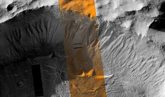
Gullies on Mars could have been formed by recent periods of liquid meltwater, study suggests A study led by Brown University researchers offers new insights into how water from melting ice could have played a recent role in the formation of ravine-like channels that cut down the sides of impact craters on Mars. The study, published in Science, focuses on Martian gullies, which look eerily similar to gullies that form on Earth in the Dry Valleys of Antarctica and are caused by water erosion from melting glaciers. The researchers, including Brown planetary scientist Jim Head, built a model that simulates a sweet spot for when conditions on Mars allow the planet to warm above freezing temperatures, leading to periods of liquid water on Mars when ice on and beneath the surface melts. The scientists found that when Mars tilts on its axis to 35 degrees, the atmosphere becomes dense enough for brief episodes of melting to occur at gully locations. They then matched the data from their model to periods in Mars history when the gullies in the planet’s Terra Sirenum region are believed to have expanded rapidly downhill from high elevation points — a phenomenon that could not be explained without the occasional presence of water. “We know from a lot of our research and other people's research that early on in Mars history, there was running water on the surface with valley networks and lakes,” said Head, a professor of geological sciences at Brown. “But about 3 billion years ago, all of that liquid water was lost, and Mars became what we call a hyper-arid or polar desert. We show here that even after that and in the recent past, when Mars’ axis tilts to 35 degrees, it heats up sufficiently to melt snow and ice, bringing liquid water back until temperatures drop and it freezes again.” The findings help fill in some of the missing gaps on how these gullies formed, including how high they start, how severe the erosion is and how far they extend down the side of craters. Previous theories suggest Martian gullies were carved by carbon dioxide frost, which evaporates from soil, causing rock and rubble to slide down slopes. The height of the gullies made many scientists theorize that meltwater from glaciers had to be involved because of the distance they traveled down the slopes and how eroded the gullies looked. Proving liquid water could exist on Mars since it disappeared so long ago has been difficult because temperatures typically hover about 70 degrees below freezing. The results from the new study suggest that gully formation was driven by periods of melting ice and by CO2 frost evaporation in other parts of the year. The researchers found this has likely occurred repeatedly over the past several million years with the most recent occurrence about 630,000 years ago. They say that if ice was present at gully locations in the areas they looked at when Mars’ axis tilted to about 35 degrees, the conditions would have been right for the ice to melt because temperatures rose above 273 degrees Kelvin, equivalent to about 32 degrees Fahrenheit. “Our study shows that the global distribution of gullies is better explained by liquid water over the last million years,” said Jay Dickson, the study’s lead author and a former researcher at Brown who’s now at California Institute of Technology. “Water explains the elevation distribution of gullies in ways that CO2 cannot. This means that Mars has been able to create liquid water in enough volume to erode channels within the last million years, which is very recent on the scale of Mars geologic history.” Despite doubts about meltwater being possible and scientists never being able to model the right conditions on Mars for ice to melt, the researchers were convinced that the meltwater theory was accurate because they had seen similar features firsthand in Antarctica. There, despite the cold temperatures, the sun is able to heat ice just enough for it to melt and for gully activity to occur. The new study is a continuation of previous research the team started decades earlier looking at Martian gullies. In a 2015 study, for instance, the researchers showed it was possible that there may have been past periods on Mars when water was available to form gullies if Mars tilted on its axis enough. The findings encouraged them to model what that tilt was and match it with the locations and altitudes of gullies that have formed. The paper raises anew the fundamental question of whether life could exist on Mars. This is because life, as it’s known on Earth, goes hand in hand with the presence of liquid water. Mars will eventually tilt to 35 degrees again, the researchers said. “Could there be a bridge, if you will, between the early warm and wet Mars and the Mars that we see today in terms of liquid water?” Head said. “Everybody's always looking for environments that could be conducive to not just the formation of life but the preservation and continuation of it. Any microorganism that might have evolved in early Mars is going to be in places where they can be comfortable in ice and then also comfortable or prosperous in liquid water. In the frigid Antarctic environment, for example, the few organisms that exist often occur in stasis, waiting for water.” The study also introduces the importance of these gullies in terms of potential targets to visit during future exploration missions on Mars. The study included funding from the NASA Mars Data Analysis Program. Other Brown-affiliated authors include former graduate students Ashley Palumbo and Laura Kerber, former graduate student and postdoctoral researcher Caleb Fassett and visiting researcher Mikhail Kreslavsky, a planetary scientist at University of California, Santa Cruz.
4 notes
·
View notes
Text
The Toughest Lizard On Earth
Ghidorah is taking a long, slow boat ride from Antarctica back to Isla de Mara, courtesy of a rather reluctant supercarrier. It is, they think, a fairly pleasant ride.
Until Godzilla shows up.
And Ghidorah doesn't even know how to properly diss him.
This is part of an ongoing series of Rodorah one-shots—although this one is low on the Rodorah and mainly pure shenanigans. If you don’t wanna read the others, all you need to know is: Ghidorah's wing is currently shredded, hence their inability to fly; Ghidorah does not speak any Earth languages but is slowly learning Rodan’s; and Rodan goes by Nido and doesn’t refer to anyone by their canon names because his species names people based on the volcano/island/geological feature they call home. Links to the other fics are in the source at the bottom of this post.
###
They didn't like riding on a machine maker ship. It reminded them too much of things they'd tried to leave behind eons ago—of metal militaries and hangars and holding pens. Of being someone's tool.
At least they could comfort themselves with the knowledge that this world's machine makers saw them as an enemy rather than a weapon.
One bold little soldier had circled around in front of them to point some kind of gun at their faces. What a heavy weapon for such a little creature! The gun was longer than its leg. Third slowly licked the gun out of the soldier's hands, made direct eye contact with the soldier, and swallowed its weapon.
No one else pointed guns at them.
The ship was painfully slow. Slow enough that even the red sprite had grown tired of serving as their escort and explained that he was going to head north—they presumed to get away from the cold—over the horizon, but close enough that he'd be able to hear if they yelled for him. They didn't begrudge him for taking a break. At this rate, they suspected it would take them half a month to get home, maybe more.
Perhaps they should tell the machine makers to drop them off somewhere they could absorb enough energy to regrow their wing. They were getting hungry—had been hungry since repairing Third after his decapitation—but they were pretty sure they could still mend the tears without straining themselves too far. A volcano would do as an energy source. When the red sprite came back, they could ask him where the nearest volcano was. (They actually had enough words that they could ask now. They were... proud of that. They were puzzled by being proud of that, when usually they were so proud of getting around from world to world without deigning to communicate with the natives—without deigning to get attached.)
For now, though, they'd content themselves with the ride.
It wasn't a bad ride, all things considered—aside from the uncomfortable sense of being in the hands of someone's military. Free drinks. They hadn't even realized they could find oil on this planet, much less that the machine makers liked to conveniently can it and leave it sitting around where they could devour it. They'd have to be on the lookout for more cans in the future. They'd resisted the urge to clear the deck of them, but they were now just tipsy enough to actually relax.
Third had let his head roll sideways and was marveling at how that made the ocean look both horizontal and vertical when their fields of vision overlapped. Second had noodled his way across First's neck to plop his head on top of Third's, and was now determinedly ignoring Third flicking out his tongue to poke at the bottom of Second's chin. First had curled up against them both, shut his eyes, and was dozing, enjoying the hazy light faintly glowing on their scales after a whole night in a frozen wasteland. Half a month of this would probably be torture, but day one was alright.
Then the little king poked his head out of the water.
Second and Third stared at the dark grey blur in the middle of their overlapping views, befuddled. First opened his eyes, just made the view more confusing, and blinked slowly.
Third recognized him first and jerked up, causing Second to slide off and land snout first on the deck. Him! What was he doing here? What did he want? Had he heard about their injury? Did he think he could kill them while they were vulnerable. They'd see about that.
One of them tried to stand on their wings and feet. Another tried to raise their wings threateningly. The end result was that they got halfway to standing, lost their balance, crashed chest-and-necks first onto the deck, and ended up rolled sideways with one leg propping up their butt and the other leg twisted sideways under them. Oh, this was not intimidating. Maybe they were more tipsy than they'd thought.
The little king, eyes barely above the water line, stared at them.
They hissed and menacingly rattled the tail that hadn't gotten caught under them.
The little king growled so low, they could feel it vibrating the ship. Oh, they ought to zap him for that. He would deserve it.
What if they got into a real fight, though? The ship would immediately sink, and then they'd be in the water with him and unable to fly, and that would be that for them.
So, they glowered at him a moment longer—and then pointedly turned away, to study the horizon as though it was far more interesting than anything he could be doing. (Two of them did, anyway. Second was put on keep-glaring-at-him duty. Because one of them had to watch him in case he tried anything, and because Second had the best glare.) What did the little king matter to them, anyway? They were on a boat and he wasn't. They had free drinks. He wished he was on a boat with free drinks. After all he did to help the itty bitty creatures of this world, and they didn't appreciate him at all, did they? No. They gave free rides to their near-conqueror instead. Look. Gaze upon their glorious ride and despair.
The little king continued to watch them with a complete lack of anything that even slightly resembled envy. Then he sank back down beneath the water.
They waited until they were absolutely sure he was gone.
Then they lifted their heads and shouted, "Hey! Nido!"
###
Nido didn't think the golden ones were in any real trouble. They hadn't sounded distressed. All the same, he took off from the beach he'd been exploring (it hadn't existed the last time he was awake!) and flew to their side as fast as possible.
Partially, he admitted, because he wanted them to see how fast he could cut across the surface of the sea.
When he reached the boat, the golden ones looked about the same as he'd left them. Still a little... drowsy, maybe? Slightly out of it. But not unwell, which was what mattered. Definitely not under attack by a sea serpent or anything, which was the important part. Trying to hover in place without blowing at the boat, he asked, "What?"
"What is bad name?"
Okay, no, Nido now had no idea what was going on. "What?"
The question didn't seem to please them. They huddled together, silently ruminating over how to clarify their meaning. "You fight... it," they said, with a vague gesture with their good wing to indicate "it." Some unspecified enemy, probably. "You not love it. Not love."
"Hate," Nido supplied.
"You hate it. You... love it loses."
"You want it to lose?"
They gave him a skeptical look. "Yes?"
Nido clicked encouragingly, go on.
"You bad name it," the golden ones said. "What is bad name?"
Oh! Okay, a word for the kind of bad name you call someone you hate. "Insult," Nido said.
"Insult." They somehow turned the word into five syllables, i-nn-sii-li-T. It was kind of an amazing sound. "Ihi." And, apparently satisfied with their answer, they immediately switched topics. "Where is... near nest?"
"Why?" Nido asked, before remembering they hadn't covered that word.
They apparently guessed the meaning. "We want us... to... sit nest."
"Good!" Nido exclaimed. That was their most complex sentence to date. And of course they wanted a volcano—even without a proper layer of armor, they still had to find lava soothing when they were wounded, didn't they? Lava was inherently soothing.
Well, there was no place like home, and certainly no place like a crater that one of his own kind had carefully shaped into a cozy nest; but in desperate times Nido figured any vent with a bit of magma would do. After all day out on a metal boat in the ocean, immediately following a night out in a blizzard—the golden ones had to be cold, damp, and sore. Nido wondered if their thin gold armor eroded like stone did.
"Yes. I fly. You follow." Nido darted north and waited, circling in the air until the golden ones had glared at the humans until they got with the program and turned to follow.
###
It took the agonizingly slow human boat over a day—but at last, they made it to the nearest volcano Nido knew of.
To humans, the island in question is called Bouvet Island. Bouvet Island has the distinction of being the single island farthest from any other piece of land on the planet.
It also has the distinction of having 93% of its surface area covered by a glacier, due to the fact that its volcano hasn't erupted in four thousand years.
The golden ones gave Nido a forlorn look.
Nido shifted uncomfortably on his icy perch. "It was supposed to be warmer."
###
The Badass Fish—as he tended to think of himself when he was around the three-headed space freak—The Badass Fish had been following the boat for the past day.
And he didn't like this.
He didn't like the sound of the space freak's beating heart so close to the sound of a thrumming human ship. He didn't like hearing Nido's cries so nearby. The humans couldn't be stupid enough to help the freak, could they?
The Badass Fish wasn't sure. Humans, he had found, were collectively a pretty stupid bunch of people. He didn't have proof, but he was pretty sure they'd brought the freak back to life in the first place. Who knew what else they might do?
So he followed.
The freak departed from the boat on a small island in the middle of nowhere, and the boat hastily chugged away. He also didn't like that. He could hear the slow, tired churning of magma deep beneath the island; he could hear the cracking and splitting of ice above. If the freak planned to dig out the volcano, then that made this lonely island a little too similar to the kind of place he'd been when he'd mind controlled the planet. Did the freak need an island volcano to min control the planet? He didn't want to find out. But it was possible.
And so, The Ass-Kickingest Fish Ever swam into shallow water, lifted his head just above the water line, and observed.
It took the freak a moment to notice him; he'd worked himself deep into a plateau of glacial ice, and was initially only visible as a moving golden glow from behind the ice. But one head popped out to scan its surroundings, caught sight of him, and then all three were focused on him.
The freak narrowed all six eyes at him.
The Meanest Bitch In Town narrowed his right back.
"You," the freak snarled venomously. He clambered out of the pit he'd dug in the ice, practically slithering down to reach the water line. The freak was favoring one wing. Was the other wounded? "Hey, you."
He jerked his head a bit higher out of the water. The freak could talk now? He'd never done that before. The Baddest Boy In The Seven Seas had tried countless times to communicate with him—in every language he knew, in body language, in Mothra-assisted telepathy even—and now, suddenly, the space freak knew how to speak?
Maybe Mothra had been right, that there was a chance he could reform. If he was even learning to speak... "What?" he asked.
The freak stared blankly at him. "... What?"
Oh. The freak could only speak volcano pter language. Figured. The Great And Terrible Gorilla-Whale switched dialects. "What is it?"
The freak drew himself as high as he could without switching to bipedalism and said to him, with equal measures of menace, derision, and hatred, "Insult."
He stared at the space freak.
The space freak stared down at him, looking three shades of smug as hell.
The Reptilian Beast Feared By All In The Galaxy Who Value Their Continued Survival said, "You're an idiot."
"What?"
The Undisputed Master Of Both Land And Sea And Also Sometimes The Air When His Sister Is There snorted, turned around, and kicked back into deep water.
Nah.
This guy wasn't destroying the world today.
###
(Replies/reblogs are welcome & encouraged! Check the “source” link below for my masterlist of Ghidorah-centric and Rodorah fics, as well as my AO3 and Ko-fi links.)
133 notes
·
View notes
Photo
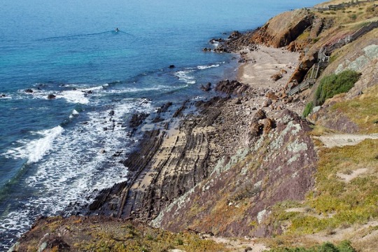
Hallett Cove - 600 million years of history at a single glance!
Depicted in these photos is the stunning geology at Hallett Cove, South Australia.
600 million years ago this entire area was submerged in the sea. Silts and sands were deposited in a deep marine, passive margin environment and then, 500 million years ago, folded and uplifted during a period of mountain-building. This mountain-building event is known as the Delamerian orogeny and was the result of stress transfer during the formation of the supercontinent Gondwana. From my understanding, the energy generated by the impact of Gondwanan formation was conducted through the crust, allowing the plate to “crumple”, causing folding and thrust faulting. The first image depicts the Wave-cut Platform, which is the eroded limb of a massive fold under Black Hill. Those bumpy, black lines are actually sedimentary beds which are now lying almost vertically due to folding.
Between 500-280 million years ago, there is an unconformity. An unconformity is essentially a record of erosion, and the parts that are “missing” can tell us a great deal about what happened to the region between the time of erosion and the next depositional event. This particular unconformity records the erosion of the Delamerian Highlands (a mountain range) into low hills.
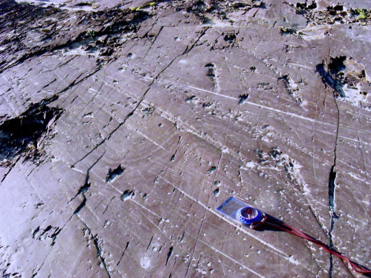
During the Permian (280 million years ago) Australia was covered by an ice sheet, similar to that which covers Antarctica at present. As the ice sheet moved toward the north-west over southern Australia, it scoured the surface and left glacial pavements. Glaciers usually pick up all kinds of rock fragments and sediments which become embedded in the underside. These etch the surface of whatever material the glacier’s underbelly comes into contact with. Because the striations are straight, we can also get a basic sense of the direction in which the glacier was moving. A world-class example of the striations made by a glacier can be seen atop Black Hill and is shown in photo #2.
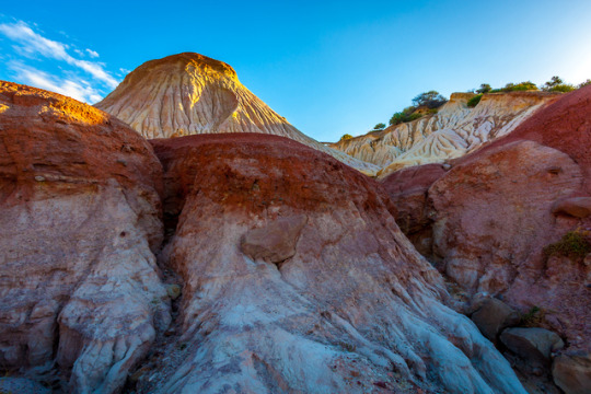
Between 280-3 million years ago, Australia began to warm and the ice started to melt. Deposits of soft, pale glacial sediments and ‘drop stones’ (also called ‘erratics’) were deposited. Drop stones are larger rock fragments that are found amongst finer-grained sediments in sedimentary rocks and can be diagnostic of past glacial activity. Photo #3 depicts evidence of glacial melting as recorded by the Sugarloaf, a large, white, cone-like structure. The Sugarloaf was formed when sediments accumulated in a lake formed by melting glaciers. There is also an unconformity here that records the period where Hallett Cove underwent a subsequent period of erosion and much of the glacial sediment was removed.
At 3 million years ago, the area underwent downfaulting, which means that it sank in relation to its surrounds. This type of faulting occurs due to extensional events where essentially, the ground pulls apart and shears apart or detaches along weak points in the Earth’s crust. Then, the newly detached material slides down to fill the void created by extension. This sunken area is also known as a ‘graben’. At Hallett Cove, the downfaulted area was submerged in a shallow, warm sea. This is evidenced by the thin layer of fossiliferous white sandstone that overlies the remaining glacial sediments. Before long, the neighbouring Mt. Lofty Ranges began another period of uplift and Hallett Cove was exposed as land yet again.
2 million years ago, a thick layer of alluvial silt and clay was deposited as a floodplain by rivers flowing down to the coast from the Mt. Lofty Ranges. Further uplift of the area (which continutes today) has resulted in even more erosion, giving the formation its characteristic ‘badlands’ appearance. Today, this feature is known as the Amphitheatre. It has a striking red colouration, caused by iron oxides (which can be seen in photo #3) and is capped by a layer of hard calcrete, which is formed when calcite-rich waters permeate calcareous soil or regolith, precipitating as a hard crust when the water evaporates at the surface. It is common in arid and semi-arid environments.
YK
Image credits: The Wave-cut Platform - “rock beach” by sunphlo (c) 2011. (https://flic.kr/p/aT9SRg). Used under creative commons licensing. The Sugarloaf - “The Hump::HDR” by Ikhwan Zailani (c) 2012. (https://commons.wikimedia.org/wiki/File:The_Hump_HDR_(8297135638).jpg). Used under creative commons licensing. Glacial Pavement atop Black Hill - "Glacial rock scrapings" by sunphlo on flickr, creative commons
Further reading: http://www.mindat.org/article.php/957/Overview+of+Hallett+Cove+Geological+History https://www.marion.sa.gov.au/hallett-cove-conservation-park http://austhrutime.com/delamerian_orogeny.htm http://crcleme.org.au/RegLandEvol/MtLofty.pdf http://www.indiana.edu/~geol105b/images/gaia_chapter_6/unconformities.htm http://users.sa.chariot.net.au/~littoral/hallettcove/geology.htm
118 notes
·
View notes
Text
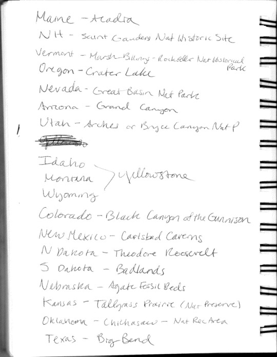
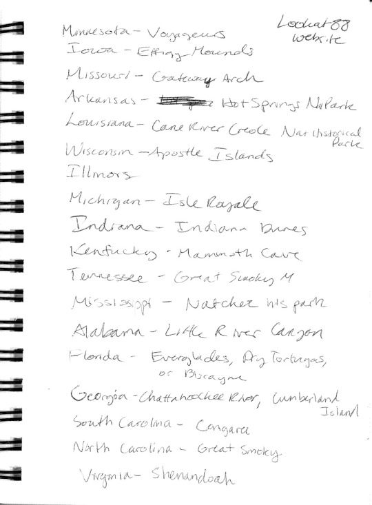
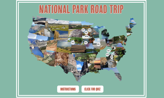
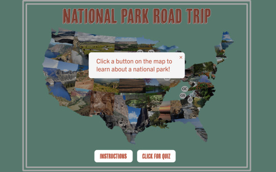
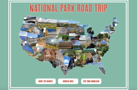
P2-Interactive Learning Game
Brainstorming and initial thoughts


Lo-fi prototype


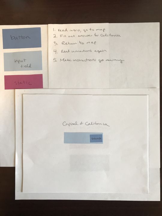


After receiving feedback from classmates and my professor, I decided to map out ten national parks with buttons instead of mapping out 50 states with buttons.
Moodboards


Style Tile

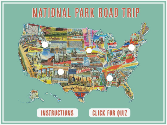
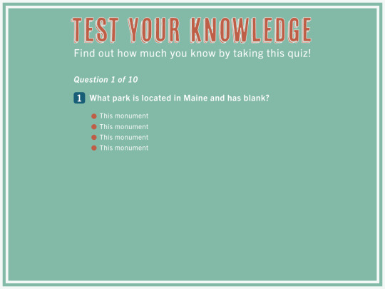
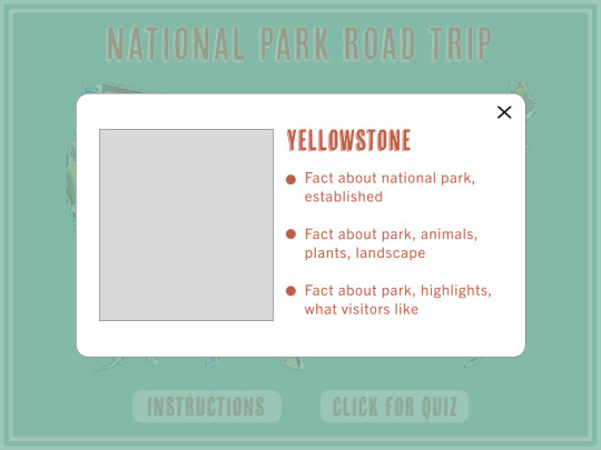
Static Digital Layout
Notes


Olympic Park:
Officially national park in 1938.
Encompassing 922,651 acres, the park protects a vast wilderness, thousands of years of human history, and several distinctly different ecosystems, including glacier-capped mountains, old-growth temperate rain forests, and over 70 miles of wild coastline.
More than 1,100 species of plants live in Olympic's meadows and forests.
Just offshore, whales, dolphins, sea lions, seals, and sea otters feed in the Pacific Ocean. Invertebrates of countless shapes, sizes, colors and textures inhabit the tide pools.
Some species, like raccoons, beaver and mink, live mostly in the lowlands. Deer, elk, cougars and bears, range from valleys to mountain meadows. Park waters are home to some of the healthiest runs of Pacific salmon outside of Alaska. Over 300 species of birds live in the area at least part of the year, from tiny penguin-like rhinoceros auklets offshore to golden eagles soaring over the peaks.
Endemic species like the Olympic marmot, Olympic snow mole and Olympic torrent salamander are found here and nowhere else in the world.
Eight contemporary tribes of the Olympic Peninsula - the Hoh, Ozette, Makah, Quinault, Quileute, Queets, Lower Elwha Klallam, and Jamestown S'Klallam - have lived in this area and have strong relationships with the lands and waters within the park.
Yosemite:
Within its nearly 1,200 square miles, you can find deep valleys, grand meadows, ancient giant sequoias, a vast wilderness area, and more.
The expansive park’s 747,956 acres or 1,169 square miles, nearly 95 percent of which are designated Wilderness, are home to hundreds of wildlife species, and over a thousand plant species.
Yosemite supports more than 400 species of vertebrates, including fish, amphibians, reptiles, birds, and mammals.
Many waterfalls, specifically 2,425-foot Yosemite Falls that ranks as the tallest in North America, flowing down into the scenic Valley meadows.
Visitors can explore 800 miles of hiking trails and 282 miles of scenic roadways.
Yosemite is the nation’s 3rd national park, but it sparked the idea of national parks. Twenty-six years before it was a national park, President Lincoln signed the Yosemite Land Grant on June 30, 1864, protecting the Mariposa Grove and Yosemite Valley. It was the first time the government protected land because of its natural beauty so people could enjoy it.
Yosemite’s granite rock formations glow like fire at sunset. Sunlight illuminates El Capitan and Half Dome in brilliant reds and oranges.
Yosemite is one of the few places in the U.S. where you can see a rainbow at night. Yosemite is world-famous for its waterfalls and the rainbows that can appear in them. But very few people know about the park’s lunar rainbows.
Glacier Park:
Pristine forests, alpine meadows, rugged mountains, and spectacular lakes.
Over 700 miles of trails.
Glacier Park's varied climate influences and its location at the headwaters of the Pacific, Atlantic and Hudson Bay drainages have given rise to an incredible variety of plants and animals.
There are 276 species of birds are found in the park, Glacier hosts 6 species of amphibians, 71 species of mammals call Glacier home. There are only three species of reptiles in the park, with a fourth suspected to be present. It is nearly impossible to know how many species of insect live in Glacier, when a single rotting log alone could host thousands. Glacier's waters host a complicated mix of native and invasive species.
The park had over 100 glaciers when it was established in 1910. By 1966, 35 glaciers remained. In 2015, only 26 met the size criteria to be designated active glaciers. Snow avalanches, ice flow dynamics, and variations in ice thickness cause some glaciers to shrink faster than others. All the glaciers have receded since 1966.
Glacier National Park is a part of the world’s first international peace park. Vision for a park was to celebrate peace and friendship between the United States and Canada.
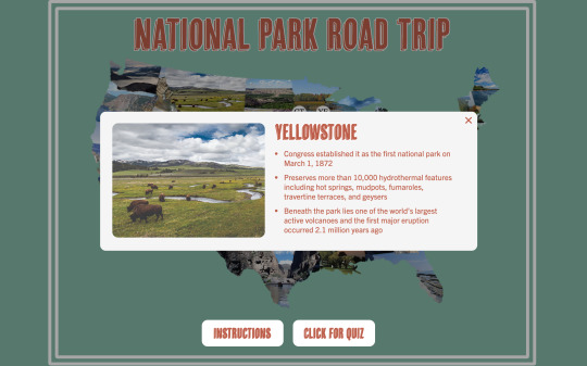
Yellowstone:
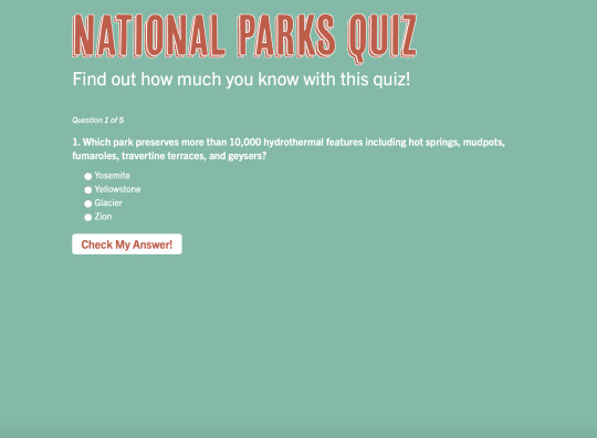
On March 1, 1872, Yellowstone became the first national park to enjoy the unique hydrothermal wonders. Preserved within are Earth's most active and diverse geysers, hot springs, mudpots, and fumaroles.
At 28,000 square miles.
Abundant and diverse: 67 species of mammals, 330 species of birds, 16 species of fish, 5 species of amphibians, 6 species of reptiles.
A volcano, geysers and other thermal features, earthquakes, and glaciers shape Yellowstone's landscape.
Half the world’s hydrothermal features are found at Yellowstone. Yellowstone National Park preserves more than 10,000 hydrothermal features -- an extraordinary collection of hot springs, mudpots, fumaroles, travertine terraces and -- of course -- geysers.
Microorganisms called thermophiles -- meaning “heat loving” -- live in these features and give the park its brilliant colors.
Old Faithful erupts more frequently than any of the other large geysers -- around 17 times a day.
World-renowned for its bison herds.
One of the world’s largest active volcanoes lies beneath Yellowstone. The first major eruption of the Yellowstone volcano occurred 2.1 million years ago and covered more than 5,790 square miles with ash.
Grand Teton:
Located in northwestern Wyoming
The elevation of the park ranges from 6,320 feet on the sagebrush-dominated valley floor to 13,770 feet on the windswept granite summit of the Grand Teton.
Long, snowy, and bitterly cold winters make the climate of Jackson Hole unforgiving. Coldest temperature ever recorded in Grand Teton National Park was -63°F, and snow often blankets the landscape from early November to May.
Grand Teton National Park was established in 1929 and then again in 1950. In 1929, President Calvin Coolidge went against enormous public opposition and approved the original 96,000-acre park, which encompassed the Teton Range and six glacial lakes. In 1943, President Franklin D. Roosevelt established the 210,000-acre Jackson Hole National Monument to protect the remaining federal lands on the valley floor. In 1950, President Harry S. Truman and Congress merged the monument, the national park and a 35,000-acre donation from John D. Rockefeller to create the 310,000-acre Grand Teton National Park.
Earthquakes gave rise to the 40-mile-long Teton Range, which sits on a fault line. The west block of land rose upward to form the mountains while the east block of land dropped down to form the valley called Jackson Hole. The Tetons are the youngest range in the Rocky Mountains and some of the youngest mountains in the world.
https://www.nathab.com/articles/us-national-parks/yellowstone/six-facts-about-grand-teton/
Zion:
Utah's First National Park.
Located in Washington, Iron, and Kane Counties in southwestern Utah. Within its 232 square miles are high plateaus, a maze of narrow, deep, sandstone canyons, and the Virgin River and its tributaries. Zion also has 2,000-foot Navajo Sandstone cliffs, pine- and juniper-clad slopes, and seeps, springs, and waterfalls supporting lush and colorful hanging gardens
Approximately 78 species of mammals, 30 species of reptiles, 7 species of amphibians, 8 species of fish, and 291 species of birds.
The geologic formations of Zion--formed over approximately 250 million years.
Before it was a national park, Zion was a national monument. The park was first protected in 1909 when President William Howard Taft designated Mukuntuweap National Monument using the power of the 1906 Antiquities Act. In the 10 years until it became a national park, it was expanded, and its name was changed to Zion.
Zion National Park's 2,000-foot sandstone cliffs are world renowned for their big wall climbs. Construction began on a 25-mile stretch of road to connect Zion to the Grand Canyon and Bryce Canyon. The 1.1-mile-long tunnel cuts through the vertical sandstone cliffs of Zion, blends in with the surrounding landscape and includes windows to provide views of Zion Canyon.
Grand Canyon:
Unique combinations of geologic color and erosional forms decorate a canyon that is 277 river miles (446km) long, up to 18 miles (29km) wide, and a mile (1.6km) deep.
On February 26, 1919, Grand Canyon became a National Park.
Is a World Heritage Site, encompasses 1,218,375 acres and lies on the Colorado Plateau in northwestern Arizona.
Over 1,500 plant, 355 bird, 89 mammalian, 47 reptile, 9 amphibian, and 17 fish species are found in park.
The Grand Canyon is bigger than the state of Rhode Island. The Grand Canyon is a mile deep, 277 miles long and 18 miles wide. While the park doesn’t include the entire canyon, it does measure in at a whopping 1,904 square miles in total. In comparison, Rhode Island is around 1,212 square miles.
Tucked within the Grand Canyon are an estimated 1,000 caves, and of those, 335 have been recorded. Even fewer have been mapped or inventoried. Only one cave is open to the public -- the Cave of the Domes on Horseshoe Mesa.
The Grand Canyon is one of the most visited national parks in the United States. An estimated 5.9 million people visit the Grand Canyon a year, making it the second most popular national park following just behind the Great Smoky Mountains of North Carolina and Tennessee.
The Grand Canyon was carved over some 6 million years. Geological activity and erosion by the Colorado River created the Grand Canyon as we know it today.
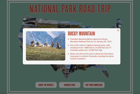
Rocky Mountain:
415 square miles encompass and protect spectacular mountain. environments. Trail Ridge Road crests at over 12,000 feet, along with over 300 miles of hiking trails, wildflowers, wildlife.
Rocky has a section just for butterflies. Over 140 species flutter around these high elevations.
Rocky Mountain is one of the nation’s highest national parks. Elevations from 7,860 feet to 14,259 feet.
Maze of evergreen trees covers the mountainsides in subalpine areas. Hidden among the trees are crystal-clear lakes and fields of wildflowers. Approximately one-third of this national park is above the limit where trees grow in northern Colorado (around 11,500 feet above sea level), creating the alpine tundra ecosystem.
Completed in 1932, Trail Ridge Road was called a "scenic wonder road of the world." The highest continuous paved highway in the nation, drivers will climb 4,000 feet in a matter of minutes.
Park is home to more than 60 species of mammals, including elk, bighorn sheep and moose. Park has more than 280 recorded bird species, six amphibians, one reptile (the harmless garter snake), 11 species of fish and countless insects, and a large number of butterflies.
Great Smoky:
World renowned for its diversity of plant and animal life, the beauty of its ancient mountains, and the quality of its remnants of Southern Appalachian mountain culture. America's most visited national park.
Encompassing over 800 square miles in the Southern Appalachian Mountains, no other area of equal size in a temperate climate can match the park's diversity. Over 19,000 species have been documented in the park and scientists believe an additional 80,000-100,000 species may live here.
One of the most stunning and rare inhabitants of the national park is the Eastern Hellbender Salamander, the 3rd largest salamander in the world. The Smokies are known as the Salamander Capital of the World and are home to 24 species of salamanders.
Bears inhabit all elevations of the park. Though populations are variable, biologists estimate that roughly 1,500 bears live in the park. Equals a population density of approximately two bears per square mile.
Over 1,500 kinds of flowering plants are found in the park, more than in any other North American national park.
Cades Cove is a broad, verdant valley surrounded by mountains and is one of the most popular destinations in the Great Smokies. Large numbers of white-tailed deer are seen, and sightings of black bear, coyote, ground hog, turkey, raccoon, skunk, and other animals are also possible.
Protected in the park are some 65 species of mammals, over 200 varieties of birds, 67 native fish species, and more than 80 types of reptiles and amphibians.
Acadia:
Seven peaks above 1,000 feet, 158 miles of hiking trails, and 45 miles of carriage roads with 16 stone bridges.
First established in 1919.
More than 47,000-acre preserve is located mostly on Mount Desert Island, a 108-square-mile coastal island shaped like a lobster’s claw. Other bits of Acadia are scattered on smaller nearby islands and on a peninsula jutting from Maine’s shoreline.
1,530-foot-high Cadillac Mountain, the tallest point on the eastern coast of the United States.
Thunder Hole, a semi-submerged cave off the coast of Mount Desert Island where crashing waves sound like bolts of thunder.
https://kids.nationalgeographic.com/explore/nature/acadia/#Acadia-lighthouse.jpg
Park has not always been know as Acadia National Park. It was first called Sieur de Monts National Monument (1916 – 1919). The name was than changed to Lafayette National Park until January 19, 1929 before it became Acadia National Park.
There are 26 different mountains within the park.
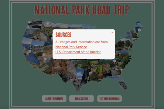
All info from:
https://www.nps.gov/index.htm
https://www.doi.gov
Progress on building site

Final Coded Site

1 note
·
View note
Text
Top 10 Best Places to Visit in Chile: The Only List You Need
Chile is located in the western corner of South America. It stretches over six thousand miles along the coast of the Pacific Ocean. Chile is known for its football. But when it comes to the best places to visit in Chile, it leaves behind the neighbors like Brazil and Argentina. The landscape is so diverse that many travelers would pick Chile over its neighbors.
What Makes Chile So Special?
If this question comes to your head, then you’re thinking the wrong way, or you don’t know about Chile at all. What isn’t special about Chile? The peak of the Andes Mountains, magnificent sunny beaches, forests, volcanoes – whatever you associate with adventure, Chile has it. That’s why these places are gaining more and more tourists every day.
Chile is home to some amazing conservation and national parks that are popular travel destinations among the tourist community. You can go trekking or hiking if you’re the adventurous type.
The opportunities are endless for adventure seekers in Chile. Mountain biking, climbing, horseback riding, and river rafting are some of the popular choices.
The cultural attractions in Chile are in abundance. Santiago, the capital of Chile is a host to many art galleries and museums while Easter Island has mysterious stone figures.
Top 10 Best Places to Visit in Chile
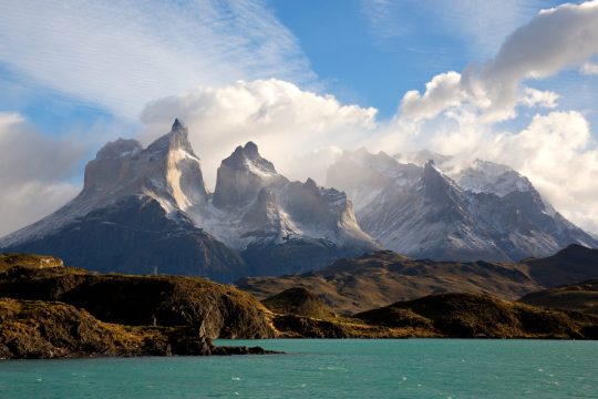
1. Torres Del Paine National Park

Source
Torres Del Paine is god’s work of art. It’s becoming a prominent tourist attraction, and, naturally, it’s of great importance to Chile. Everything in the vicinity is picturesque. The lakes and rivers flow gently beside the plain grassland. In the background, breathtaking mountains and glaciers almost touch the sky. If you were having a bad day, this place would bring you back to life.
There are multiple trails in the park for travelers to go on hiking. You can also stay overnight and trek the entirety of the mountain. If you hike for a day, then you can do it in a group. But hiking longer than a day requires you to tag along with a professional guide. This is a safety precaution issued by the park authority.
Many tourists go on a 5-day trek that reaches the top of Patagonia. The path is 71 KM long, so it’s going to be a tough journey. But the views you get are incomparable. The grey glacier and the Paine Grande Mountain are also visible along the path. In the end, this journey is worth it.
2. Valle de la Luna and the Atacama Desert
The Valley of Moon is the direct translation of Valle de la Luna. The name itself is intriguing enough to get anyone off their seat. It’s located near Chile’s border with Bolivia, thirteen kilometers away from San Pedro de Atacama. You can go there by tour buses, car rentals or if you’re feeling adventurous you can take a bike and follow the bike trails.
The valley has an uncanny resemblance to the moon’s surface. That’s why people visit in huge numbers. The inhospitable climate has always attracted human civilization, and Chile is no different. Unique geological features in the valley are caused by erosion of the red rocks. The hostile environment couldn’t stop flora and fauna from evolving and adapting to the surroundings.
The dry lake and riverbeds attract both researchers and tourists. It’s one of the driest locations on the earth. The soil samples are quite different from any other place on earth because of salt deposits and naturally infused saline.
A fun fact about the Atacama Desert: The Chinchorro mummies stored in San Miguel de Azama archaeological museum were discovered in this valley. There are other pieces of evidence of ancient civilization residing here, including rock paintings and pictographs.
3. Santiago: The Capital of Chile
Santiago is vital for everything related to Chile. Finance, Businesses, culture, economy everything is dependent on a functioning Santiago. Culturally Santiago resembles a lot of European countries. They have tried to store their history and showcase it proudly through museums and galleries. Shopping and dining options, coupled with the diverse nightlife of Santiago, make it a must-visit place.
No matter where you go inside Chile, you’ll start your journey from the capital as it’s the main transportation hub. Before going to the Easter Islands or the Atacama Desert, explore the city. Otherwise, your Chilean experience would be incomplete.
The city started its journey in 1541, and it has evolved drastically over the years. The good part about Santiago is that it’s not overpopulated, unlike other South American cities. So, you can go about your day without having to bump into people now and then. The Museo Nacional de Bellas Artes (Chilean National Museum of Fine Arts) is a good place to start in the city. There’s another museum which has artifacts from the Pre-Colombian era called Museo Nacional de Bellas Artes
Santiago tour would be incomplete without riding the aerial tramway. Use the tram to go to San Cristóbal Hill, and you’ll get the best possible view of this magnificent city. On the hill, you’ll find a statue of Mother Mary, which is twenty-two meters high. You can end the Santiago tour at Parque Metropolitano de Santiago. This park has green spaces in an urban setting, a funicular railway, and the Chilean National Zoo
4. Easter Island & Rapa Nui National Park
The Island was named by a Dutch explorer, but it was discovered back in 1722 by Europeans. Polynesians have lived on this remote island for thousands of years. Although it’s far away from the mainland, it remains the best Chile has to offer. The stone sculptures near the beaches make this place truly remarkable.
UNESCO has already declared this island as a World Heritage Site. The statues were made by Rapa Nui civilization, and now the Rapa Nui National Park protects all 887 statues on the island. The largest platform of the island consists of 15 statues which were re-erected.
On this island, you’ll find breathtaking beaches with green water. White coral along the beaches and coral reef beneath the ocean is quite similar to the Maldives. But the setting is much more spiritual.
There are museums on the island that hosts ancient artifacts of the Rapa Nui civilization and their leaders. You should check them out as well.
You should visit Easter Island as a part of the Chilean trip. Flights are available from Santiago, and it takes 5 hours to reach the island. So, pack your bags for a few days at least.
5. Valparaíso

Source
Valparaíso is the 3rd largest city in Chile. It’s situated between the Pacific Ocean and a mountain range. It’s a two hours’ drive from Santiago to Valparaíso. So you can check this place off your list within a day.
The old cobbled streets, harbor, beaches and one-of-a-kind architecture make this place perfect for European and American tourists. Some of you would be excited to know that Pablo Neruda used to walk through these streets and get ideas for his poems.
The city focuses on its oceanic heritage and it shows. Museo Naval Y Maritimo is a maritime museum that displays artifacts from the Pacific War of 1879. Museo Lord Cochrane is another museum that was built by Lord Cochrane.
6. Chilean Lake District
The Chilean Lake District is often termed as the Alpine of South America. It stretches from Puerto Montt to Temuca for over 330 kilometers. The Andean foothill region is rich farmland. The volcanoes in this area are almost hidden behind thick forests. The Lake District also has deep lakes that are suitable for different water sports.
Some time back, the indigenous people of this territory were forced to move elsewhere. European settlers arrived in this place and made it their own and started mixing with the locals. Mainly, the farmers from Germany, Switzerland, and Austria came and settled here. The hint of European culture is quite visible in Osorno’s architecture. Various norms and cultural traits here are also influenced by the Europeans
This is a heaven for adventurers and adrenaline junkies. Volcano climbing is now becoming very popular among the tourists. You can also choose safer options like hiking, kayaking, horseback riding, and water rafting. During the winter, you can ski as well.
7. Pumalín Park
Pumalín Park is quite similar to the Torres Del Paine National park. It was established as a sanctuary back in 2005. The park covers a total area of 988,000 acres. It starts at the Andes and ends on the Pacific Ocean. The pristine coastline, forests, and mountains are integral parts of this sanctuary.
The reason why this place has remained so picturesque is that we humans haven’t touched it yet. The impact of urbanization hasn’t reached Chile. Pumalin Park is home to diverse flora and fauna. The park is currently owned by a US-based Nature Conservation Agency. Visitors can access the park with prior permission.
They do a very good job of providing visitors with an actual wilderness experience. This is possible only because the Park authority has made campgrounds, visitor facilities, hike trails while keeping in mind the environmental impacts of such structures. You can either stay here for a small period by going on a hike or get a cabin to stay the night. No matter how you spend your time at Pumalin Park, you’ll cherish this experience for years to come.
8. Chiloé Island & Chiloé National Park
Chiloé Island is Chile’s second-largest island. While the ambiance may not be comparable to some of the other places on the list, it still is amongst the top-visited places by travelers. You’ll have a more relaxed experience here.
When you reach the island, the first thing you’ll notice is that the topography is quite similar to rural Europe, especially Germany. After the world war, many Germans escaped and came to South America. That’s why so many places have European influence on its culture and architecture. You can explore the island on foot. The wooden churches are iconic in this part of the world. The colorful wooden and semi-wooden houses built near the water catch the eye of every tourist – a perfect place to take a photo for your Instagram. These houses are called palafitos and they are one of the main attractions of this place.
You’ll get to see the ocean wildlife in its natural habitat if you come to this small island. Blue whales and dolphins jump out of the waters to entertain their traveler friends. This island is also a breeding area for penguins. They arrive in a flock and lay eggs on the beach. As travelers, you must protect these magnificent wild species.
9. Valle Nevado
https://youtu.be/r7MWk2qeir0
Most people had no idea that Chile had so many snowy mountains which are perfect for skiing and other winter sports. But the tourist spots like Valle Nevada are starting to gain traction. The Valle Nevada is now amongst the most popular skiing spots in South America. The resorts are located in the foothill of the Andes in El Plomo. This place was made in 1988 as a skiing spot. It’s fair to say, it serves its purpose efficiently.
The skiing range has an altitude of 3000 meters. You can ski here almost one-third of the year because of the clear blue skies. The resort has 11 lifts and 38 trails. The resort also features a variety of condos, chalets, and rooms. You can stay there for a day or two to get used to the Chilean snow. La Parva and El Colorado are two nearby skiing spots that are also tourist-friendly.
10. Los Pingüinos Monument
The Monument area is a breeding location for penguins, as the name Los Pingüinos suggests. This part is only accessible by guided boats because Chile is putting more focus on conserving its diverse wildlife. Huge colonies of sea lions and seals have made this island their home. This monument is a part of the magnificent Marta islands and Magdalena.
Final Thoughts
Every location on this list is unique and represents the diversity of Chile. This thin and long country boasts some of the best scenic places in the world, and you won’t be disappointed no matter which one you pick from this list of the best places to visit in Chile.
The blog post Top 10 Best Places to Visit in Chile: The Only List You Need Find more at: Holiday Nomad
Top 10 Best Places to Visit in Chile: The Only List You Need posted first on https://holidaynomad.com/
0 notes
Text
Top 10 Best Places to Visit in Chile: The Only List You Need
Chile is located in the western corner of South America. It stretches over six thousand miles along the coast of the Pacific Ocean. Chile is known for its football. But when it comes to the best places to visit in Chile, it leaves behind the neighbors like Brazil and Argentina. The landscape is so diverse that many travelers would pick Chile over its neighbors.
What Makes Chile So Special?
If this question comes to your head, then you’re thinking the wrong way, or you don’t know about Chile at all. What isn’t special about Chile? The peak of the Andes Mountains, magnificent sunny beaches, forests, volcanoes – whatever you associate with adventure, Chile has it. That’s why these places are gaining more and more tourists every day.
Chile is home to some amazing conservation and national parks that are popular travel destinations among the tourist community. You can go trekking or hiking if you’re the adventurous type.
The opportunities are endless for adventure seekers in Chile. Mountain biking, climbing, horseback riding, and river rafting are some of the popular choices.
The cultural attractions in Chile are in abundance. Santiago, the capital of Chile is a host to many art galleries and museums while Easter Island has mysterious stone figures.
Top 10 Best Places to Visit in Chile
1. Torres Del Paine National Park
Source
Torres Del Paine is god’s work of art. It’s becoming a prominent tourist attraction, and, naturally, it’s of great importance to Chile. Everything in the vicinity is picturesque. The lakes and rivers flow gently beside the plain grassland. In the background, breathtaking mountains and glaciers almost touch the sky. If you were having a bad day, this place would bring you back to life.
There are multiple trails in the park for travelers to go on hiking. You can also stay overnight and trek the entirety of the mountain. If you hike for a day, then you can do it in a group. But hiking longer than a day requires you to tag along with a professional guide. This is a safety precaution issued by the park authority.
Many tourists go on a 5-day trek that reaches the top of Patagonia. The path is 71 KM long, so it’s going to be a tough journey. But the views you get are incomparable. The grey glacier and the Paine Grande Mountain are also visible along the path. In the end, this journey is worth it.
2. Valle de la Luna and the Atacama Desert
The Valley of Moon is the direct translation of Valle de la Luna. The name itself is intriguing enough to get anyone off their seat. It’s located near Chile’s border with Bolivia, thirteen kilometers away from San Pedro de Atacama. You can go there by tour buses, car rentals or if you’re feeling adventurous you can take a bike and follow the bike trails.
The valley has an uncanny resemblance to the moon’s surface. That’s why people visit in huge numbers. The inhospitable climate has always attracted human civilization, and Chile is no different. Unique geological features in the valley are caused by erosion of the red rocks. The hostile environment couldn’t stop flora and fauna from evolving and adapting to the surroundings.
The dry lake and riverbeds attract both researchers and tourists. It’s one of the driest locations on the earth. The soil samples are quite different from any other place on earth because of salt deposits and naturally infused saline.
A fun fact about the Atacama Desert: The Chinchorro mummies stored in San Miguel de Azama archaeological museum were discovered in this valley. There are other pieces of evidence of ancient civilization residing here, including rock paintings and pictographs.
3. Santiago: The Capital of Chile
Santiago is vital for everything related to Chile. Finance, Businesses, culture, economy everything is dependent on a functioning Santiago. Culturally Santiago resembles a lot of European countries. They have tried to store their history and showcase it proudly through museums and galleries. Shopping and dining options, coupled with the diverse nightlife of Santiago, make it a must-visit place.
No matter where you go inside Chile, you’ll start your journey from the capital as it’s the main transportation hub. Before going to the Easter Islands or the Atacama Desert, explore the city. Otherwise, your Chilean experience would be incomplete.
The city started its journey in 1541, and it has evolved drastically over the years. The good part about Santiago is that it’s not overpopulated, unlike other South American cities. So, you can go about your day without having to bump into people now and then. The Museo Nacional de Bellas Artes (Chilean National Museum of Fine Arts) is a good place to start in the city. There’s another museum which has artifacts from the Pre-Colombian era called Museo Nacional de Bellas Artes
Santiago tour would be incomplete without riding the aerial tramway. Use the tram to go to San Cristóbal Hill, and you’ll get the best possible view of this magnificent city. On the hill, you’ll find a statue of Mother Mary, which is twenty-two meters high. You can end the Santiago tour at Parque Metropolitano de Santiago. This park has green spaces in an urban setting, a funicular railway, and the Chilean National Zoo
4. Easter Island & Rapa Nui National Park
The Island was named by a Dutch explorer, but it was discovered back in 1722 by Europeans. Polynesians have lived on this remote island for thousands of years. Although it’s far away from the mainland, it remains the best Chile has to offer. The stone sculptures near the beaches make this place truly remarkable.
UNESCO has already declared this island as a World Heritage Site. The statues were made by Rapa Nui civilization, and now the Rapa Nui National Park protects all 887 statues on the island. The largest platform of the island consists of 15 statues which were re-erected.
On this island, you’ll find breathtaking beaches with green water. White coral along the beaches and coral reef beneath the ocean is quite similar to the Maldives. But the setting is much more spiritual.
There are museums on the island that hosts ancient artifacts of the Rapa Nui civilization and their leaders. You should check them out as well.
You should visit Easter Island as a part of the Chilean trip. Flights are available from Santiago, and it takes 5 hours to reach the island. So, pack your bags for a few days at least.
5. Valparaíso

Source
Valparaíso is the 3rd largest city in Chile. It’s situated between the Pacific Ocean and a mountain range. It’s a two hours’ drive from Santiago to Valparaíso. So you can check this place off your list within a day.
The old cobbled streets, harbor, beaches and one-of-a-kind architecture make this place perfect for European and American tourists. Some of you would be excited to know that Pablo Neruda used to walk through these streets and get ideas for his poems.
The city focuses on its oceanic heritage and it shows. Museo Naval Y Maritimo is a maritime museum that displays artifacts from the Pacific War of 1879. Museo Lord Cochrane is another museum that was built by Lord Cochrane.
6. Chilean Lake District
The Chilean Lake District is often termed as the Alpine of South America. It stretches from Puerto Montt to Temuca for over 330 kilometers. The Andean foothill region is rich farmland. The volcanoes in this area are almost hidden behind thick forests. The Lake District also has deep lakes that are suitable for different water sports.
Some time back, the indigenous people of this territory were forced to move elsewhere. European settlers arrived in this place and made it their own and started mixing with the locals. Mainly, the farmers from Germany, Switzerland, and Austria came and settled here. The hint of European culture is quite visible in Osorno’s architecture. Various norms and cultural traits here are also influenced by the Europeans
This is a heaven for adventurers and adrenaline junkies. Volcano climbing is now becoming very popular among the tourists. You can also choose safer options like hiking, kayaking, horseback riding, and water rafting. During the winter, you can ski as well.
7. Pumalín Park
Pumalín Park is quite similar to the Torres Del Paine National park. It was established as a sanctuary back in 2005. The park covers a total area of 988,000 acres. It starts at the Andes and ends on the Pacific Ocean. The pristine coastline, forests, and mountains are integral parts of this sanctuary.
The reason why this place has remained so picturesque is that we humans haven’t touched it yet. The impact of urbanization hasn’t reached Chile. Pumalin Park is home to diverse flora and fauna. The park is currently owned by a US-based Nature Conservation Agency. Visitors can access the park with prior permission.
They do a very good job of providing visitors with an actual wilderness experience. This is possible only because the Park authority has made campgrounds, visitor facilities, hike trails while keeping in mind the environmental impacts of such structures. You can either stay here for a small period by going on a hike or get a cabin to stay the night. No matter how you spend your time at Pumalin Park, you’ll cherish this experience for years to come.
8. Chiloé Island & Chiloé National Park
Chiloé Island is Chile’s second-largest island. While the ambiance may not be comparable to some of the other places on the list, it still is amongst the top-visited places by travelers. You’ll have a more relaxed experience here.
When you reach the island, the first thing you’ll notice is that the topography is quite similar to rural Europe, especially Germany. After the world war, many Germans escaped and came to South America. That’s why so many places have European influence on its culture and architecture. You can explore the island on foot. The wooden churches are iconic in this part of the world. The colorful wooden and semi-wooden houses built near the water catch the eye of every tourist – a perfect place to take a photo for your Instagram. These houses are called palafitos and they are one of the main attractions of this place.
You’ll get to see the ocean wildlife in its natural habitat if you come to this small island. Blue whales and dolphins jump out of the waters to entertain their traveler friends. This island is also a breeding area for penguins. They arrive in a flock and lay eggs on the beach. As travelers, you must protect these magnificent wild species.
9. Valle Nevado
https://youtu.be/r7MWk2qeir0
Most people had no idea that Chile had so many snowy mountains which are perfect for skiing and other winter sports. But the tourist spots like Valle Nevada are starting to gain traction. The Valle Nevada is now amongst the most popular skiing spots in South America. The resorts are located in the foothill of the Andes in El Plomo. This place was made in 1988 as a skiing spot. It’s fair to say, it serves its purpose efficiently.
The skiing range has an altitude of 3000 meters. You can ski here almost one-third of the year because of the clear blue skies. The resort has 11 lifts and 38 trails. The resort also features a variety of condos, chalets, and rooms. You can stay there for a day or two to get used to the Chilean snow. La Parva and El Colorado are two nearby skiing spots that are also tourist-friendly.
10. Los Pingüinos Monument
The Monument area is a breeding location for penguins, as the name Los Pingüinos suggests. This part is only accessible by guided boats because Chile is putting more focus on conserving its diverse wildlife. Huge colonies of sea lions and seals have made this island their home. This monument is a part of the magnificent Marta islands and Magdalena.
Final Thoughts
Every location on this list is unique and represents the diversity of Chile. This thin and long country boasts some of the best scenic places in the world, and you won’t be disappointed no matter which one you pick from this list of the best places to visit in Chile.
The blog post Top 10 Best Places to Visit in Chile: The Only List You Need Find more at: Holiday Nomad
Top 10 Best Places to Visit in Chile: The Only List You Need posted first on https://holidaynomad.com/
0 notes
Text
Top 10 Best Places to Visit in Chile: The Only List You Need
Chile is located in the western corner of South America. It stretches over six thousand miles along the coast of the Pacific Ocean. Chile is known for its football. But when it comes to the best places to visit in Chile, it leaves behind the neighbors like Brazil and Argentina. The landscape is so diverse that many travelers would pick Chile over its neighbors.
What Makes Chile So Special?
If this question comes to your head, then you’re thinking the wrong way, or you don’t know about Chile at all. What isn’t special about Chile? The peak of the Andes Mountains, magnificent sunny beaches, forests, volcanoes – whatever you associate with adventure, Chile has it. That’s why these places are gaining more and more tourists every day.
Chile is home to some amazing conservation and national parks that are popular travel destinations among the tourist community. You can go trekking or hiking if you’re the adventurous type.
The opportunities are endless for adventure seekers in Chile. Mountain biking, climbing, horseback riding, and river rafting are some of the popular choices.
The cultural attractions in Chile are in abundance. Santiago, the capital of Chile is a host to many art galleries and museums while Easter Island has mysterious stone figures.
Top 10 Best Places to Visit in Chile
1. Torres Del Paine National Park

Source
Torres Del Paine is god’s work of art. It’s becoming a prominent tourist attraction, and, naturally, it’s of great importance to Chile. Everything in the vicinity is picturesque. The lakes and rivers flow gently beside the plain grassland. In the background, breathtaking mountains and glaciers almost touch the sky. If you were having a bad day, this place would bring you back to life.
There are multiple trails in the park for travelers to go on hiking. You can also stay overnight and trek the entirety of the mountain. If you hike for a day, then you can do it in a group. But hiking longer than a day requires you to tag along with a professional guide. This is a safety precaution issued by the park authority.
Many tourists go on a 5-day trek that reaches the top of Patagonia. The path is 71 KM long, so it’s going to be a tough journey. But the views you get are incomparable. The grey glacier and the Paine Grande Mountain are also visible along the path. In the end, this journey is worth it.
2. Valle de la Luna and the Atacama Desert
The Valley of Moon is the direct translation of Valle de la Luna. The name itself is intriguing enough to get anyone off their seat. It’s located near Chile’s border with Bolivia, thirteen kilometers away from San Pedro de Atacama. You can go there by tour buses, car rentals or if you’re feeling adventurous you can take a bike and follow the bike trails.
The valley has an uncanny resemblance to the moon’s surface. That’s why people visit in huge numbers. The inhospitable climate has always attracted human civilization, and Chile is no different. Unique geological features in the valley are caused by erosion of the red rocks. The hostile environment couldn’t stop flora and fauna from evolving and adapting to the surroundings.
The dry lake and riverbeds attract both researchers and tourists. It’s one of the driest locations on the earth. The soil samples are quite different from any other place on earth because of salt deposits and naturally infused saline.
A fun fact about the Atacama Desert:The Chinchorro mummies stored in San Miguel de Azama archaeological museum were discovered in this valley. There are other pieces of evidence of ancient civilization residing here, including rock paintings and pictographs.
3. Santiago: The Capital of Chile
Santiago is vital for everything related to Chile. Finance, Businesses, culture, economy everything is dependent on a functioning Santiago. Culturally Santiago resembles a lot of European countries. They have tried to store their history and showcase it proudly through museums and galleries. Shopping and dining options, coupled with the diverse nightlife of Santiago, make it a must-visit place.
No matter where you go inside Chile, you’ll start your journey from the capital as it’s the main transportation hub. Before going to the Easter Islands or the Atacama Desert, explore the city. Otherwise, your Chilean experience would be incomplete.
The city started its journey in 1541, and it has evolved drastically over the years. The good part about Santiago is that it’s not overpopulated, unlike other South American cities. So, you can go about your day without having to bump into people now and then. The Museo Nacional de Bellas Artes (Chilean National Museum of Fine Arts) is a good place to start in the city. There’s another museum which has artifacts from the Pre-Colombian era called Museo Nacional de Bellas Artes
Santiago tour would be incomplete without riding the aerial tramway. Use the tram to go to San Cristóbal Hill, and you’ll get the best possible view of this magnificent city. On the hill, you’ll find a statue of Mother Mary, which is twenty-two meters high. You can end the Santiago tour at Parque Metropolitano de Santiago. This park has green spaces in an urban setting, a funicular railway, and the Chilean National Zoo
4. Easter Island & Rapa Nui National Park
The Island was named by a Dutch explorer, but it was discovered back in 1722 by Europeans. Polynesians have lived on this remote island for thousands of years. Although it’s far away from the mainland, it remains the best Chile has to offer. The stone sculptures near the beaches make this place truly remarkable.
UNESCO has already declared this island as a World Heritage Site. The statues were made by Rapa Nui civilization, and now the Rapa Nui National Park protects all 887 statues on the island. The largest platform of the island consists of 15 statues which were re-erected.
On this island, you’ll find breathtaking beaches with green water. White coral along the beaches and coral reef beneath the ocean is quite similar to the Maldives. But the setting is much more spiritual.
There are museums on the island that hosts ancient artifacts of the Rapa Nui civilization and their leaders. You should check them out as well.
You should visit Easter Island as a part of the Chilean trip. Flights are available from Santiago, and it takes 5 hours to reach the island. So, pack your bags for a few days at least.
5. Valparaíso

Source
Valparaíso is the 3rd largest city in Chile. It’s situated between the Pacific Ocean and a mountain range. It’s a two hours’ drive from Santiago to Valparaíso. So you can check this place off your list within a day.
The old cobbled streets, harbor, beaches and one-of-a-kind architecture make this place perfect for European and American tourists. Some of you would be excited to know that Pablo Neruda used to walk through these streets and get ideas for his poems.
The city focuses on its oceanic heritage and it shows. Museo Naval Y Maritimo is a maritime museum that displays artifacts from the Pacific War of 1879. Museo Lord Cochrane is another museum that was built by Lord Cochrane.
6. Chilean Lake District
The Chilean Lake District is often termed as the Alpine of South America. It stretches from Puerto Montt to Temuca for over 330 kilometers. The Andean foothill region is rich farmland. The volcanoes in this area are almost hidden behind thick forests. The Lake District also has deep lakes that are suitable for different water sports.
Some time back, the indigenous people of this territory were forced to move elsewhere. European settlers arrived in this place and made it their own and started mixing with the locals. Mainly, the farmers from Germany, Switzerland, and Austria came and settled here. The hint of European culture is quite visible in Osorno’s architecture. Various norms and cultural traits here are also influenced by the Europeans
This is a heaven for adventurers and adrenaline junkies. Volcano climbing is now becoming very popular among the tourists. You can also choose safer options like hiking, kayaking, horseback riding, and water rafting. During the winter, you can ski as well.
7. Pumalín Park
Pumalín Park is quite similar to the Torres Del Paine National park. It was established as a sanctuary back in 2005. The park covers a total area of 988,000 acres. It starts at the Andes and ends on the Pacific Ocean. The pristine coastline, forests, and mountains are integral parts of this sanctuary.
The reason why this place has remained so picturesque is that we humans haven’t touched it yet. The impact of urbanization hasn’t reached Chile. Pumalin Park is home to diverse flora and fauna. The park is currently owned by a US-based Nature Conservation Agency. Visitors can access the park with prior permission.
They do a very good job of providing visitors with an actual wilderness experience. This is possible only because the Park authority has made campgrounds, visitor facilities, hike trails while keeping in mind the environmental impacts of such structures. You can either stay here for a small period by going on a hike or get a cabin to stay the night. No matter how you spend your time at Pumalin Park, you’ll cherish this experience for years to come.
8. Chiloé Island & Chiloé National Park
Chiloé Island is Chile’s second-largest island. While the ambiance may not be comparable to some of the other places on the list, it still is amongst the top-visited places by travelers. You’ll have a more relaxed experience here.
When you reach the island, the first thing you’ll notice is that the topography is quite similar to rural Europe, especially Germany. After the world war, many Germans escaped and came to South America. That’s why so many places have European influence on its culture and architecture. You can explore the island on foot. The wooden churches are iconic in this part of the world. The colorful wooden and semi-wooden houses built near the water catch the eye of every tourist – a perfect place to take a photo for your Instagram. These houses are called palafitos and they are one of the main attractions of this place.
You’ll get to see the ocean wildlife in its natural habitat if you come to this small island. Blue whales and dolphins jump out of the waters to entertain their traveler friends. This island is also a breeding area for penguins. They arrive in a flock and lay eggs on the beach. As travelers, you must protect these magnificent wild species.
9. Valle Nevado
https://youtu.be/r7MWk2qeir0
Most people had no idea that Chile had so many snowy mountains which are perfect for skiing and other winter sports. But the tourist spots like Valle Nevada are starting to gain traction. The Valle Nevada is now amongst the most popular skiing spots in South America. The resorts are located in the foothill of the Andes in El Plomo. This place was made in 1988 as a skiing spot. It’s fair to say, it serves its purpose efficiently.
The skiing range has an altitude of 3000 meters. You can ski here almost one-third of the year because of the clear blue skies. The resort has 11 lifts and 38 trails. The resort also features a variety of condos, chalets, and rooms. You can stay there for a day or two to get used to the Chilean snow. La Parva and El Colorado are two nearby skiing spots that are also tourist-friendly.
10. Los Pingüinos Monument
The Monument area is a breeding location for penguins, as the name Los Pingüinos suggests. This part is only accessible by guided boats because Chile is putting more focus on conserving its diverse wildlife. Huge colonies of sea lions and seals have made this island their home. This monument is a part of the magnificent Marta islands and Magdalena.
Final Thoughts
Every location on this list is unique and represents the diversity of Chile. This thin and long country boasts some of the best scenic places in the world, and you won’t be disappointed no matter which one you pick from this list of the best places to visit in Chile.
Top 10 Best Places to Visit in Chile: The Only List You Need was first seen on Holiday Nomad
Top 10 Best Places to Visit in Chile: The Only List You Need published first on https://holidaynomad.com/
0 notes
Text
Top 10 Best Places to Visit in Chile: The Only List You Need
Chile is located in the western corner of South America. It stretches over six thousand miles along the coast of the Pacific Ocean. Chile is known for its football. But when it comes to the best places to visit in Chile, it leaves behind the neighbors like Brazil and Argentina. The landscape is so diverse that many travelers would pick Chile over its neighbors.
What Makes Chile So Special?
If this question comes to your head, then you’re thinking the wrong way, or you don’t know about Chile at all. What isn’t special about Chile? The peak of the Andes Mountains, magnificent sunny beaches, forests, volcanoes – whatever you associate with adventure, Chile has it. That’s why these places are gaining more and more tourists every day.
Chile is home to some amazing conservation and national parks that are popular travel destinations among the tourist community. You can go trekking or hiking if you're the adventurous type.
The opportunities are endless for adventure seekers in Chile. Mountain biking, climbing, horseback riding, and river rafting are some of the popular choices.
The cultural attractions in Chile are in abundance. Santiago, the capital of Chile is a host to many art galleries and museums while Easter Island has mysterious stone figures.
Top 10 Best Places to Visit in Chile
1. Torres Del Paine National Park

Source
Torres Del Paine is god's work of art. It’s becoming a prominent tourist attraction, and, naturally, it's of great importance to Chile. Everything in the vicinity is picturesque. The lakes and rivers flow gently beside the plain grassland. In the background, breathtaking mountains and glaciers almost touch the sky. If you were having a bad day, this place would bring you back to life.
There are multiple trails in the park for travelers to go on hiking. You can also stay overnight and trek the entirety of the mountain. If you hike for a day, then you can do it in a group. But hiking longer than a day requires you to tag along with a professional guide. This is a safety precaution issued by the park authority.
Many tourists go on a 5-day trek that reaches the top of Patagonia. The path is 71 KM long, so it's going to be a tough journey. But the views you get are incomparable. The grey glacier and the Paine Grande Mountain are also visible along the path. In the end, this journey is worth it.
2. Valle de la Luna and the Atacama Desert
The Valley of Moon is the direct translation of Valle de la Luna. The name itself is intriguing enough to get anyone off their seat. It’s located near Chile’s border with Bolivia, thirteen kilometers away from San Pedro de Atacama. You can go there by tour buses, car rentals or if you’re feeling adventurous you can take a bike and follow the bike trails.
The valley has an uncanny resemblance to the moon's surface. That's why people visit in huge numbers. The inhospitable climate has always attracted human civilization, and Chile is no different. Unique geological features in the valley are caused by erosion of the red rocks. The hostile environment couldn't stop flora and fauna from evolving and adapting to the surroundings.
The dry lake and riverbeds attract both researchers and tourists. It’s one of the driest locations on the earth. The soil samples are quite different from any other place on earth because of salt deposits and naturally infused saline.
A fun fact about the Atacama Desert: The Chinchorro mummies stored in San Miguel de Azama archaeological museum were discovered in this valley. There are other pieces of evidence of ancient civilization residing here, including rock paintings and pictographs.
3. Santiago: The Capital of Chile
Santiago is vital for everything related to Chile. Finance, Businesses, culture, economy everything is dependent on a functioning Santiago. Culturally Santiago resembles a lot of European countries. They have tried to store their history and showcase it proudly through museums and galleries. Shopping and dining options, coupled with the diverse nightlife of Santiago, make it a must-visit place.
No matter where you go inside Chile, you’ll start your journey from the capital as it’s the main transportation hub. Before going to the Easter Islands or the Atacama Desert, explore the city. Otherwise, your Chilean experience would be incomplete.
The city started its journey in 1541, and it has evolved drastically over the years. The good part about Santiago is that it's not overpopulated, unlike other South American cities. So, you can go about your day without having to bump into people now and then. The Museo Nacional de Bellas Artes (Chilean National Museum of Fine Arts) is a good place to start in the city. There’s another museum which has artifacts from the Pre-Colombian era called Museo Nacional de Bellas Artes
Santiago tour would be incomplete without riding the aerial tramway. Use the tram to go to San Cristóbal Hill, and you’ll get the best possible view of this magnificent city. On the hill, you'll find a statue of Mother Mary, which is twenty-two meters high. You can end the Santiago tour at Parque Metropolitano de Santiago. This park has green spaces in an urban setting, a funicular railway, and the Chilean National Zoo
4. Easter Island & Rapa Nui National Park
The Island was named by a Dutch explorer, but it was discovered back in 1722 by Europeans. Polynesians have lived on this remote island for thousands of years. Although it’s far away from the mainland, it remains the best Chile has to offer. The stone sculptures near the beaches make this place truly remarkable.
UNESCO has already declared this island as a World Heritage Site. The statues were made by Rapa Nui civilization, and now the Rapa Nui National Park protects all 887 statues on the island. The largest platform of the island consists of 15 statues which were re-erected.
On this island, you’ll find breathtaking beaches with green water. White coral along the beaches and coral reef beneath the ocean is quite similar to the Maldives. But the setting is much more spiritual.
There are museums on the island that hosts ancient artifacts of the Rapa Nui civilization and their leaders. You should check them out as well.
You should visit Easter Island as a part of the Chilean trip. Flights are available from Santiago, and it takes 5 hours to reach the island. So, pack your bags for a few days at least.
5. Valparaíso
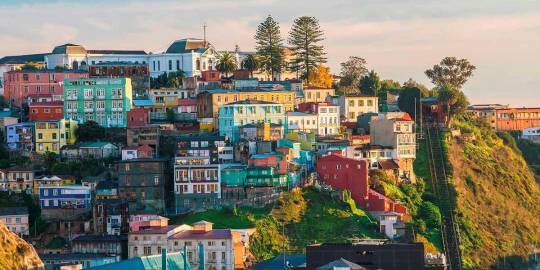
Source
Valparaíso is the 3rd largest city in Chile. It’s situated between the Pacific Ocean and a mountain range. It’s a two hours’ drive from Santiago to Valparaíso. So you can check this place off your list within a day.
The old cobbled streets, harbor, beaches and one-of-a-kind architecture make this place perfect for European and American tourists. Some of you would be excited to know that Pablo Neruda used to walk through these streets and get ideas for his poems.
The city focuses on its oceanic heritage and it shows. Museo Naval Y Maritimo is a maritime museum that displays artifacts from the Pacific War of 1879. Museo Lord Cochrane is another museum that was built by Lord Cochrane.
6. Chilean Lake District
The Chilean Lake District is often termed as the Alpine of South America. It stretches from Puerto Montt to Temuca for over 330 kilometers. The Andean foothill region is rich farmland. The volcanoes in this area are almost hidden behind thick forests. The Lake District also has deep lakes that are suitable for different water sports.
Some time back, the indigenous people of this territory were forced to move elsewhere. European settlers arrived in this place and made it their own and started mixing with the locals. Mainly, the farmers from Germany, Switzerland, and Austria came and settled here. The hint of European culture is quite visible in Osorno's architecture. Various norms and cultural traits here are also influenced by the Europeans
This is a heaven for adventurers and adrenaline junkies. Volcano climbing is now becoming very popular among the tourists. You can also choose safer options like hiking, kayaking, horseback riding, and water rafting. During the winter, you can ski as well.
7. Pumalín Park
Pumalín Park is quite similar to the Torres Del Paine National park. It was established as a sanctuary back in 2005. The park covers a total area of 988,000 acres. It starts at the Andes and ends on the Pacific Ocean. The pristine coastline, forests, and mountains are integral parts of this sanctuary.
The reason why this place has remained so picturesque is that we humans haven't touched it yet. The impact of urbanization hasn't reached Chile. Pumalin Park is home to diverse flora and fauna. The park is currently owned by a US-based Nature Conservation Agency. Visitors can access the park with prior permission.
They do a very good job of providing visitors with an actual wilderness experience. This is possible only because the Park authority has made campgrounds, visitor facilities, hike trails while keeping in mind the environmental impacts of such structures. You can either stay here for a small period by going on a hike or get a cabin to stay the night. No matter how you spend your time at Pumalin Park, you’ll cherish this experience for years to come.
8. Chiloé Island & Chiloé National Park
Chiloé Island is Chile's second-largest island. While the ambiance may not be comparable to some of the other places on the list, it still is amongst the top-visited places by travelers. You’ll have a more relaxed experience here.
When you reach the island, the first thing you’ll notice is that the topography is quite similar to rural Europe, especially Germany. After the world war, many Germans escaped and came to South America. That's why so many places have European influence on its culture and architecture. You can explore the island on foot. The wooden churches are iconic in this part of the world. The colorful wooden and semi-wooden houses built near the water catch the eye of every tourist – a perfect place to take a photo for your Instagram. These houses are called palafitos and they are one of the main attractions of this place.
You’ll get to see the ocean wildlife in its natural habitat if you come to this small island. Blue whales and dolphins jump out of the waters to entertain their traveler friends. This island is also a breeding area for penguins. They arrive in a flock and lay eggs on the beach. As travelers, you must protect these magnificent wild species.
9. Valle Nevado
https://youtu.be/r7MWk2qeir0
Most people had no idea that Chile had so many snowy mountains which are perfect for skiing and other winter sports. But the tourist spots like Valle Nevada are starting to gain traction. The Valle Nevada is now amongst the most popular skiing spots in South America. The resorts are located in the foothill of the Andes in El Plomo. This place was made in 1988 as a skiing spot. It’s fair to say, it serves its purpose efficiently.
The skiing range has an altitude of 3000 meters. You can ski here almost one-third of the year because of the clear blue skies. The resort has 11 lifts and 38 trails. The resort also features a variety of condos, chalets, and rooms. You can stay there for a day or two to get used to the Chilean snow. La Parva and El Colorado are two nearby skiing spots that are also tourist-friendly.
10. Los Pingüinos Monument
The Monument area is a breeding location for penguins, as the name Los Pingüinos suggests. This part is only accessible by guided boats because Chile is putting more focus on conserving its diverse wildlife. Huge colonies of sea lions and seals have made this island their home. This monument is a part of the magnificent Marta islands and Magdalena.
Final Thoughts
Every location on this list is unique and represents the diversity of Chile. This thin and long country boasts some of the best scenic places in the world, and you won’t be disappointed no matter which one you pick from this list of the best places to visit in Chile.
The blog post Top 10 Best Places to Visit in Chile: The Only List You Need Find more at: Holiday Nomad
Top 10 Best Places to Visit in Chile: The Only List You Need posted first on https://holidaynomad.com/
0 notes
Text
Top 10 Best Places to Visit in Chile: The Only List You Need
Chile is located in the western corner of South America. It stretches over six thousand miles along the coast of the Pacific Ocean. Chile is known for its football. But when it comes to the best places to visit in Chile, it leaves behind the neighbors like Brazil and Argentina. The landscape is so diverse that many travelers would pick Chile over its neighbors.
What Makes Chile So Special?
If this question comes to your head, then you’re thinking the wrong way, or you don’t know about Chile at all. What isn’t special about Chile? The peak of the Andes Mountains, magnificent sunny beaches, forests, volcanoes – whatever you associate with adventure, Chile has it. That’s why these places are gaining more and more tourists every day.
Chile is home to some amazing conservation and national parks that are popular travel destinations among the tourist community. You can go trekking or hiking if you're the adventurous type.
The opportunities are endless for adventure seekers in Chile. Mountain biking, climbing, horseback riding, and river rafting are some of the popular choices.
The cultural attractions in Chile are in abundance. Santiago, the capital of Chile is a host to many art galleries and museums while Easter Island has mysterious stone figures.
Top 10 Best Places to Visit in Chile
1. Torres Del Paine National Park

Source
Torres Del Paine is god's work of art. It’s becoming a prominent tourist attraction, and, naturally, it's of great importance to Chile. Everything in the vicinity is picturesque. The lakes and rivers flow gently beside the plain grassland. In the background, breathtaking mountains and glaciers almost touch the sky. If you were having a bad day, this place would bring you back to life.
There are multiple trails in the park for travelers to go on hiking. You can also stay overnight and trek the entirety of the mountain. If you hike for a day, then you can do it in a group. But hiking longer than a day requires you to tag along with a professional guide. This is a safety precaution issued by the park authority.
Many tourists go on a 5-day trek that reaches the top of Patagonia. The path is 71 KM long, so it's going to be a tough journey. But the views you get are incomparable. The grey glacier and the Paine Grande Mountain are also visible along the path. In the end, this journey is worth it.
2. Valle de la Luna and the Atacama Desert
The Valley of Moon is the direct translation of Valle de la Luna. The name itself is intriguing enough to get anyone off their seat. It’s located near Chile’s border with Bolivia, thirteen kilometers away from San Pedro de Atacama. You can go there by tour buses, car rentals or if you’re feeling adventurous you can take a bike and follow the bike trails.
The valley has an uncanny resemblance to the moon's surface. That's why people visit in huge numbers. The inhospitable climate has always attracted human civilization, and Chile is no different. Unique geological features in the valley are caused by erosion of the red rocks. The hostile environment couldn't stop flora and fauna from evolving and adapting to the surroundings.
The dry lake and riverbeds attract both researchers and tourists. It’s one of the driest locations on the earth. The soil samples are quite different from any other place on earth because of salt deposits and naturally infused saline.
A fun fact about the Atacama Desert: The Chinchorro mummies stored in San Miguel de Azama archaeological museum were discovered in this valley. There are other pieces of evidence of ancient civilization residing here, including rock paintings and pictographs.
3. Santiago: The Capital of Chile
Santiago is vital for everything related to Chile. Finance, Businesses, culture, economy everything is dependent on a functioning Santiago. Culturally Santiago resembles a lot of European countries. They have tried to store their history and showcase it proudly through museums and galleries. Shopping and dining options, coupled with the diverse nightlife of Santiago, make it a must-visit place.
No matter where you go inside Chile, you’ll start your journey from the capital as it’s the main transportation hub. Before going to the Easter Islands or the Atacama Desert, explore the city. Otherwise, your Chilean experience would be incomplete.
The city started its journey in 1541, and it has evolved drastically over the years. The good part about Santiago is that it's not overpopulated, unlike other South American cities. So, you can go about your day without having to bump into people now and then. The Museo Nacional de Bellas Artes (Chilean National Museum of Fine Arts) is a good place to start in the city. There’s another museum which has artifacts from the Pre-Colombian era called Museo Nacional de Bellas Artes
Santiago tour would be incomplete without riding the aerial tramway. Use the tram to go to San Cristóbal Hill, and you’ll get the best possible view of this magnificent city. On the hill, you'll find a statue of Mother Mary, which is twenty-two meters high. You can end the Santiago tour at Parque Metropolitano de Santiago. This park has green spaces in an urban setting, a funicular railway, and the Chilean National Zoo
4. Easter Island & Rapa Nui National Park
The Island was named by a Dutch explorer, but it was discovered back in 1722 by Europeans. Polynesians have lived on this remote island for thousands of years. Although it’s far away from the mainland, it remains the best Chile has to offer. The stone sculptures near the beaches make this place truly remarkable.
UNESCO has already declared this island as a World Heritage Site. The statues were made by Rapa Nui civilization, and now the Rapa Nui National Park protects all 887 statues on the island. The largest platform of the island consists of 15 statues which were re-erected.
On this island, you’ll find breathtaking beaches with green water. White coral along the beaches and coral reef beneath the ocean is quite similar to the Maldives. But the setting is much more spiritual.
There are museums on the island that hosts ancient artifacts of the Rapa Nui civilization and their leaders. You should check them out as well.
You should visit Easter Island as a part of the Chilean trip. Flights are available from Santiago, and it takes 5 hours to reach the island. So, pack your bags for a few days at least.
5. Valparaíso

Source
Valparaíso is the 3rd largest city in Chile. It’s situated between the Pacific Ocean and a mountain range. It’s a two hours’ drive from Santiago to Valparaíso. So you can check this place off your list within a day.
The old cobbled streets, harbor, beaches and one-of-a-kind architecture make this place perfect for European and American tourists. Some of you would be excited to know that Pablo Neruda used to walk through these streets and get ideas for his poems.
The city focuses on its oceanic heritage and it shows. Museo Naval Y Maritimo is a maritime museum that displays artifacts from the Pacific War of 1879. Museo Lord Cochrane is another museum that was built by Lord Cochrane.
6. Chilean Lake District
The Chilean Lake District is often termed as the Alpine of South America. It stretches from Puerto Montt to Temuca for over 330 kilometers. The Andean foothill region is rich farmland. The volcanoes in this area are almost hidden behind thick forests. The Lake District also has deep lakes that are suitable for different water sports.
Some time back, the indigenous people of this territory were forced to move elsewhere. European settlers arrived in this place and made it their own and started mixing with the locals. Mainly, the farmers from Germany, Switzerland, and Austria came and settled here. The hint of European culture is quite visible in Osorno's architecture. Various norms and cultural traits here are also influenced by the Europeans
This is a heaven for adventurers and adrenaline junkies. Volcano climbing is now becoming very popular among the tourists. You can also choose safer options like hiking, kayaking, horseback riding, and water rafting. During the winter, you can ski as well.
7. Pumalín Park
Pumalín Park is quite similar to the Torres Del Paine National park. It was established as a sanctuary back in 2005. The park covers a total area of 988,000 acres. It starts at the Andes and ends on the Pacific Ocean. The pristine coastline, forests, and mountains are integral parts of this sanctuary.
The reason why this place has remained so picturesque is that we humans haven't touched it yet. The impact of urbanization hasn't reached Chile. Pumalin Park is home to diverse flora and fauna. The park is currently owned by a US-based Nature Conservation Agency. Visitors can access the park with prior permission.
They do a very good job of providing visitors with an actual wilderness experience. This is possible only because the Park authority has made campgrounds, visitor facilities, hike trails while keeping in mind the environmental impacts of such structures. You can either stay here for a small period by going on a hike or get a cabin to stay the night. No matter how you spend your time at Pumalin Park, you’ll cherish this experience for years to come.
8. Chiloé Island & Chiloé National Park
Chiloé Island is Chile's second-largest island. While the ambiance may not be comparable to some of the other places on the list, it still is amongst the top-visited places by travelers. You’ll have a more relaxed experience here.
When you reach the island, the first thing you’ll notice is that the topography is quite similar to rural Europe, especially Germany. After the world war, many Germans escaped and came to South America. That's why so many places have European influence on its culture and architecture. You can explore the island on foot. The wooden churches are iconic in this part of the world. The colorful wooden and semi-wooden houses built near the water catch the eye of every tourist – a perfect place to take a photo for your Instagram. These houses are called palafitos and they are one of the main attractions of this place.
You’ll get to see the ocean wildlife in its natural habitat if you come to this small island. Blue whales and dolphins jump out of the waters to entertain their traveler friends. This island is also a breeding area for penguins. They arrive in a flock and lay eggs on the beach. As travelers, you must protect these magnificent wild species.
9. Valle Nevado
https://youtu.be/r7MWk2qeir0
Most people had no idea that Chile had so many snowy mountains which are perfect for skiing and other winter sports. But the tourist spots like Valle Nevada are starting to gain traction. The Valle Nevada is now amongst the most popular skiing spots in South America. The resorts are located in the foothill of the Andes in El Plomo. This place was made in 1988 as a skiing spot. It’s fair to say, it serves its purpose efficiently.
The skiing range has an altitude of 3000 meters. You can ski here almost one-third of the year because of the clear blue skies. The resort has 11 lifts and 38 trails. The resort also features a variety of condos, chalets, and rooms. You can stay there for a day or two to get used to the Chilean snow. La Parva and El Colorado are two nearby skiing spots that are also tourist-friendly.
10. Los Pingüinos Monument
The Monument area is a breeding location for penguins, as the name Los Pingüinos suggests. This part is only accessible by guided boats because Chile is putting more focus on conserving its diverse wildlife. Huge colonies of sea lions and seals have made this island their home. This monument is a part of the magnificent Marta islands and Magdalena.
Final Thoughts
Every location on this list is unique and represents the diversity of Chile. This thin and long country boasts some of the best scenic places in the world, and you won’t be disappointed no matter which one you pick from this list of the best places to visit in Chile.
The blog post Top 10 Best Places to Visit in Chile: The Only List You Need Find more at: Holiday Nomad
Top 10 Best Places to Visit in Chile: The Only List You Need posted first on https://holidaynomad.com/
0 notes
Photo
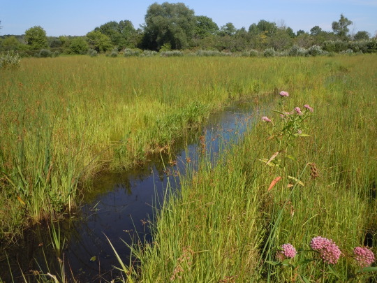
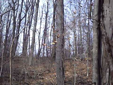
Herrick Fen State Nature Preserve 8260 Seasons Road Streetsboro, OH 44241 Preserving 127 acres in Portage County, OH, the J. Arthur Herrick Fen Preserve, located on Seasons Road near Streetsboro, OH, is one of the last remaining boreal fens in Ohio. It provides habitat for over two dozen state-listed species. Herrick Fen Preserve features unique geologic, hydrologic, biologic and physical features that resulted from the retreat of glaciers during the last ice age. The preserve hosts two special fen communities, its tamarack and cinquefoil-sedge fen communities, owing their presence to an impermeable silt and clay layer covered with glacial gravel that allows for the rise of cold, calcium, and magnesium rich springs. The tamarack fen is the only native conifer in Ohio that sheds its needles each year, and the preserve boasts one of the few reproducing populations of it in the state. The cinquefoil-sedge fen contains an extensive population of bayberry, a state endangered plant found in only three locations in Ohio. All told, the preserve provides habitat for over two dozen state-listed species. The preserve lies within the Tinker's Creek watershed in the glaciated Allegheny Plateau region of northeastern Ohio. The site lies on a buried preglacial valley filled with silt and gravel that allows for the rise of cold, calcium and magnesium rich springs which promote the presence of the fen communities here. Herrick Fen was created in 1953 when an earthen dam was built across a tributary of Tinker's Creek, impacting the original extent of the fen communities. The lake has produced a mosaic of wetland communities, providing habitat for a variety of aquatic species and opportunities for observing waterfowl and migratory bird species. A beech-maple forest borders the wetland on the northeast side and mixed hardwood forest occurs on the southern edge. The preserve provides habitat for more than 20 state-listed plants including yellow sedge, crinkled hairgrass, water avens, bunchflower, autumn willow and green cotton-grass. The initial preserve tract was purchased by Dr. J. Arthur Herrick in 1969 and now comprises some 140 acres. It is jointly owned by The Nature Conservancy and Kent State University, and managed by the Conservancy as a dedicated state nature preserve. Threats to the preserve include urban encroachment, siltation, and invasive non-native plant species such as buckthorn, cattail and reed canarygrass. Extensive and prolonged fluctuations in the lake level can negatively impact the fen community, especially the tamaracks which are sensitive to high water levels caused by beaver activity in the preserve. The ecological goal for this preserve is to restore or maintain the biodiversity of the tamarack fen and cinquefoil-sedge fens through aggressive invasive species control and management of the lake’s water level.
0 notes
Link
This is terrifying.
A few years ago, James Hansen, the godfather of global-warming science, told me that he believed the IPCC estimates were far too conservative and that the waters could rise as much as 10 feet by 2100. For Hansen, the past is prologue. Three million years ago, during the Pliocene Epoch, when the level of CO2 in the atmosphere was about the same as it is today, and temperatures were only slightly warmer, the seas were at least 20 feet higher. That suggests there is a lot of melting to come before the ice sheets reach a happy equilibrium. Mountain glaciers could contribute a little bit, as would the thermal expansion of the oceans as they warmed, but to get to more than 20 feet of sea-level rise, Greenland and Antarctica would both have to contribute in a big way.
[...]
But in recent years, things have gotten weird in Antarctica. The first alarming event was the sudden collapse, in 2002, of the Larsen B ice shelf, a vast chunk of ice on the Antarctic Peninsula. An ice shelf is like an enormous fingernail that grows off the end of a glacier where it meets the water. The glaciers behind the Larsen B, like many glaciers in both Antarctica and Greenland, are known as "marine-terminating glaciers," because large portions of them lie below sea level. The collapse of ice shelves does not in itself contribute to sea-level rise, since they are already floating (just like ice melting in a glass doesn't raise the level of liquid). But they perform an important role in buttressing, or restraining, the glaciers. After the Larsen B ice shelf vanished, the glaciers that had been behind it started flowing into the sea up to eight times faster than they had before. "It was like, 'Oh, what is going on here?' " says Ted Scambos, lead scientist at the National Snow and Ice Data Center in Boulder, Colorado. "It turns out glaciers are much more responsive than anyone thought."
[...]
One day, Alley was thinking about a problem that Dave Pollard, a colleague at Penn State, and Rob DeConto, a climate scientist at the University of Massachusetts, Amherst, had been having with their climate model. DeConto and Pollard had been collaborating for years to develop a sophisticated model to help them understand the impact of warming from fossil-fuel pollution on Greenland and Antarctica. Climate models are computer programs that try to capture fundamental physics of the natural world, such as, if the temperature warms one degree, how much will the seas around the world rise? It is not a simple question, and requires calculating everything from changes in how much sunlight the ice reflects to how much one degree of heat causes the Atlantic Ocean to expand. Models have gotten a lot better in the past few decades, but they still can't simulate all the processes in the real world.
One way that scientists test how well a model might predict the future is by seeing how well it recreates the past. If you can run a model backward and it gets things right, then you can run it forward and trust that the results might be accurate. For years, DeConto and Pollard have been trying to get their model to re-create the Pliocene, the era 3 million years ago when the CO2 levels in the atmosphere were very close to what they are today, except the seas were 20 feet higher. But no matter what knobs they turned, they couldn't get their model to melt the ice sheets fast enough to replicate what the geological record told them had happened. "We knew something was missing from the dynamics of our model," DeConto tells me.
Alley suggested they plug in his new understanding of ice physics, including the structural integrity of the ice itself (or lack thereof), and "see what happens." They did, and lo, their model worked. They were able to get the Pliocene melt just about right. In effect, they found the missing mechanism. Their model was now road-tested for accuracy.
The next thing that DeConto and Pollard did, of course, was run the model forward. What they found was that, in high-emissions scenarios – that is, the track we are on today – instead of virtually zero contribution to sea-level rise from Antarctica by 2100, they got more than three feet, most of it from West Antarctica. If you add in a fairly conservative estimate of the contribution to sea-level rise from Greenland in the same time frame, as well as expansion of the oceans, you get more than six feet – that's double the high-end IPCC scenario.
For anyone living in Miami Beach or Brooklyn or Boston's Back Bay or any other low-lying coastal neighborhood, the difference between three feet of sea-level rise by 2100 and six feet is the difference between a wet but livable city and a submerged city – billions of dollars worth of coastal real estate, not to mention the lives of the 145 million people who live less than three feet above sea level, many of them in poor nations like Bangladesh and Indonesia. The difference between three feet and six feet is the difference between a manageable coastal evacuation and a decades-long refugee disaster. For many Pacific island nations, it is the difference between survival and extinction.
[...]
In any case, the threat is clear. In a rational world, awareness of these risks would lead to deep and rapid cuts in carbon pollution to slow the warming, as well as investment in more research in West Antarctica to get a clearer understanding of what is going on. Instead, Americans elected a president who thinks climate change is a hoax, who is hellbent on burning more fossil fuels, who installs the CEO of the world's largest oil company as secretary of state, who wants to slash climate-science funding and instead spend nearly $70 billion to build a wall at the Mexican border and another $54 billion to beef up the military.
[...]
In the end, no one can say exactly how much longer the West Antarctica glaciers will remain stable. "We just don't know what the upper boundary is for how fast this can happen," Alley says, sounding a bit spooked. "We are dealing with an event that no human has ever witnessed before. We have no analogue for this." But it is clear that thanks to our 200-year-long fossil-fuel binge, the collapse of West Antarctica is already underway, and every Miami Beach condo owner and Bangladeshi farmer is living at the mercy of ice physics right now. Alley himself would never put it this way, but in West Antarctica, scientists have discovered the engine of catastrophe.
28 notes
·
View notes
Text
The Glorious Resurrection of Bouvet Island
Things that Rodan currently regrets, in order from least to most: Ghidorah can’t fly due to a wing injury; Rodan’s about to freeze solid; it’s their third night in the Antarctic; and due to some out-of-date information on the active volcanoes in the region, they’ve accidentally stranded themselves on a glaciated rock that hasn’t seen flowing lava in so long it’s forgotten what lava looks like. In a situation like this, there’s really only one logical thing Rodan can do:
Harass the volcano until either it goes off or he dies. Easy!
This is part of an ongoing series of Rodorah one-shots. If you don’t wanna read the others, all you need to know is: They’ve just spent like three days in the Antarctic circle and Rodan Is In Frosty Ice Hell; Ghidorah’s wing is currently shredded, so they stopped at a volcanic island to repair it only to find the volcano is iced over; Ghidorah’s an empath (telepathically transmits/detects emotions) but it only works with head-to-head contact; he doesn’t speak any Earth languages but is slowly learning Rodan’s; and Rodan goes by Nido and doesn’t refer to anyone by their canon names because his species names people based on the volcano/island/geological feature they call home. Links to the other fics are in the source at the bottom of this post.
###
"Aw, gross," Nido muttered, looking down at the trail of ashes he was leaving behind. He lifted a wing, shook it, and watched with distaste as more gray dust floated out of the pores that were supposed to be dripping lava and fire. No wonder he couldn't feel his wing tips. He flapped a couple of times, trying to warm himself up. It didn't help. It just shed more ash on the ice.
He needed to get home. He was going to freeze solid if he didn't warm up soon. His blood was going to turn to stone and here he'd stay, an extremely impressive bird statue on the world's loneliest island.
But going home would mean abandoning the golden ones. And if Nido was cold, they had to be three-fourths of the way to a popsicle. What if they needed his help?
The golden ones had worked late into the night, cracking their way through the glacier to the old caldera buried underneath; and as the temperatures had plummeted through the night, Nido had circled the island a few times to keep his magma moving. Nido wanted to help, but he didn't know if he was still warm enough to melt the ice without icing himself. Each time he returned from a flight, he chipped and pecked ineffectively at the ice until he couldn't stand the cold anymore, and took off again.
He was amazed at the progress the golden ones were making. The frigid conditions didn't seem to slow them down at all. Even with their injured wing. He wondered how they could stand it.
By the time Nido returned near dawn, they'd dug their way down to the caldera and were scraping the last of the ice out of the way as he landed. It was a relief to have dry ground under his talons, even if it wasn't much warmer than the glacier.
"Good," they said, glancing over him. The middle head's gaze lingered on him a little more sharply, taking in the dark edges of his wings. Embarrassed, he tried to fold them so that the edges weren't as visible. Yeah, he was looking ugly, he knew it.
"You—you, nest—" They looked down at the caldera under their feet, tails lashing back and forth in annoyance as they searched for useful words. And then—startling Nido into hopping back—they flung their wings up, sparks crackling at the tips, and did a remarkably accurate impression of the sound of a volcano erupting.
Nido squawked in delight. "Erupt," he said.
"You erupt nest. Yes, no?"
Nido looked at the caldera, tapped it with his talons, bent low to listen to it. Damn, this volcano probably hadn't been fit to be a nest since before Nido was born. It still had a spark of life to it, though—and knocking a glacier off the top of it had helped reduce some of the pressure keeping it sedated. He could crack open a volcano like this—in minutes if he was incredibly lucky, weeks if he wasn't, but most likely a few days. He wasn't warm enough to keep at it for several days, though.
He'd have to try anyway. The golden ones needed to warm up. They couldn't sit here alone and wait until Nido flew to an already-active volcano to recover some of his strength.
"Maybe," he said. At least he could try. If he failed—and didn't exhaust himself in the effort—he'd have no choice but to find somewhere to recover and come back as fast as possible. Hopefully he could at least stir up the volcano enough to crack open a couple of vents; that could help heat the golden ones a little. "You—sit there." He kicked a rock up and headbutted it onto the ice. The golden ones had to move carefully to avoid straining their injured wing, but they managed to climb out of the crater they'd created in the glacier and sat on top of it, watching.
Nido took off.
Those who watched his kind at work had a lot of misconceptions about how they set off volcanoes. Many thought it was their heat that did it, as they swooped low and snapped their flame-streaking wings down over closed calderas. Some even thought it was actual magic: a ritualistic dance used to awaken a sleeping mountain and call its magma to the surface. He had been told by those old enough to have met others of his kind that many of them did treat it like a sacred dance. He understood. There was, indeed, something spiritual in the act—something sublime—something that made him feel connected to the Earth down to its very core.
But the actual ability to set off a volcano wasn't magic, and it didn't come from fire. It came from air and stone.
Nido's wings were strong enough that he could launch himself from his nest at dawn, circle the planet, and arrive home before solar noon. They were strong enough to strip trees from their soil, leaving vast acres flattened with their roots stretching higher than their branches. And, when he dove from far above the clouds, pulling himself down toward the Earth with his wings as though trying to crash, flattening his wings against his back as he reached his top speed, flying so fast that he couldn't breathe, so fast he couldn't see, so fast that he had to know the precise moment to spread his wings before he'd even broken through cloud cover because by the time he saw his target it would be too late to save himself—when he was flying that fast, his wings were strong enough that the wind from his downstroke beat on the surface of a caldera so hard it vibrated like a drum, making the earth shake and crack.
The first time he dove, in the split second during which he was turning around and sound had a brief opportunity to catch up with him, he heard a thousand fractures in the glacier as the island beneath it flexed. He shot upward again.
The stone piled on top of magma kept it pressed down, pressurized, waiting to explode. If you were careful—if you were an expert—you could agitate the earth over a pocket of magma enough to make the stone weighing it down crack apart and move aside. Do it long enough and do it right, and the magma will burst free. Simple. The hardest part was getting the timing right so you didn't crash into the ground; but Nido had been born knowing how to do it. The rest was just repetition, until just the right rocks cracked in just the right ways.
Flames sputtered through the ashes trailing from his wings as he soared up again. He felt dizzy. As he reached the apex of his flight, he leaned back, spread his wings, shut his eyes, and for the briefest moment hung in midair, feeling the sun warming his cold chest.
And then he rolled backward and was diving again. And then again.
The third time he dove, he could hear a rumbling that he didn't think was caused by his latest downstroke. Promising. Maybe he was going to get lucky. He hoped so—he couldn't feel most of his body anymore. Trying to wake a volcano in his condition was dangerous.
As he tried to climb again, his vision went dark. For a second, he was unconscious; he woke up in freefall, wings dragging limply through the air. He could hear the golden ones' cries.
He couldn't stop when he was this close. He climbed again.
The fourth time he dove, he glimpsed the golden ones as a blur at the edge of the caldera—were they trying to reach him? They'd have to wait until he was done. The glacier had retreated, melting down with his attacks. Good. The reduced weight and extra water would also help the volcano wake up.
The fifth time he dove, he saw their lightning carving up the surface of the caldera.
He wasn't sure—he was fading fast, and at the fastest point in his dive he was falling at over thirteen thousand feet per second—but for a moment, he could have swore he saw rocks floating.
This time, he knew the ground shattered beneath his wings. He knew the volcano was awake.
He wheeled up, crossing the clouds one last time to slow himself, and then spiraled down to land next to the golden ones. The island rumbled beneath them, and the ground was already blessedly warm. He could see the last of the glacier tumbling into the ocean in chunks or seeping melted into the earth.
The golden ones had helped, hadn't they? Nido was sure they had. "Thanks," he said. And then he sagged sideways against them, dizziness overtaking him again. He wondered what it meant that their scales didn't feel cold anymore.
The first stones and sparks rolled out of the resurrected volcano.
###
When he woke up, he was half sunk into a pool of thin, runny lava, with the golden ones crouched in the pool beside him, staring intently.
The moment they saw he was awake, the middle head jerked forward to inspect Nido and the other two jerked back to give Nido space, ending up with their necks awkwardly stretched apart. "Nido good?" the middle one asked, voice strained. They reached a wing toward him, paused, pulled it back, and settled it on one of the higher rocks just above the lava. "Not bad? Are you— you—?" They made some complicated gesture with a wing and their tails. Nido blinked dazedly at it. It took him a moment to realize they were using their tails to point at the gashes he'd ripped in their right wing. Trying to ask if he was injured?
"I'll be fine," he groaned. "Just... need a minute." How long had he been out? Not more than a couple of moments, surely. The volcano had had enough time to ooze out a fair-sized lava pool—"Oh, gross. Mafic."—a fair-sized lava pool that stank to high heaven; but he could still hear stones creaking below as the volcano tried to figure out how to flow again.
"What?"
"Good," Nido clarified. "Back to good... soon." He was exhausted.
The golden ones finally settled back, still watching him intently. The one on their right looked away first; the other two slowly lowered, unevenly, looking at him from different heights. "Us— We..." Whatever they wanted to say, they didn't have the words for it yet. They hissed and muttered together, then gave up and waded deeper into the caldera.
As Nido watched, they stretched in the warm lava, spreading their wings, arching their necks—and then, to his alarm, bent forward and shuddered in pain—and then, so impossibly fast he thought the cold might be playing tricks with his eyes, the tattered gashes torn in their injured wing knitted themselves shut. A thin film stretching out from the corners of the rip, pulling the hanging flaps back into place, fusing them into a whole again. Nido blinked, trying to dispel the mirage. But there it remained: a perfectly whole membrane where a vicious wound used to be.
"What— How—?" He gaped at the golden ones' wing, then looked up at their faces.
Just in time for the middle head to push his forehead against Nido's shoulder, pressing him deeper into the lava. After a moment he pulled back, but only to press their foreheads together.
And as usual, the emotions tumbled forth from the golden one's mind into Nido's: the golden one was so afraid it almost made Nido nauseous. Guilt cut a jagged crack through his mind—a sharp, unfamiliar sensation. Not unfamiliar to Nido; he knew guilt, but it was smaller and softer than this, it could be dulled or brushed away. But he could feel its unfamiliarity to the golden one.
This nausea, this mind-shattering crack—was that because of him? Just because he'd worn himself out a bit?
Having that fear and guilt pressed into his mind was making him feel afraid and guilty. Nido tried to comfort the middle one, whistling a high soothing note, sliding their foreheads apart so he could run his beak beneath the middle one's horns and between the spines on his upper neck.
And then their left one pressed to Nido's forehead, desperately, eagerly; his guilt and fear were smaller, almost numb, but his mind was overrun with an aching yearning. There was love in this one too, Nido discovered—this was the first time he'd felt the left one's mind—but it was nothing like the oversized, sudden, fragile thing that had bloomed inside the middle's mind; this one's love was something old, threadbare, worn away but for a few iron-hard strands. Something suffocating in the dark.
There was a wordless plea in his mind, so Nido turned, whistling the same high note to him and giving his horns and spines the same attention.
The golden ones shuddered so hard that Nido, pressed between two of their heads, trembled too. They dragged themselves closer to him, pressed their smooth chest against his, and curled their wings loosely around him, leaving just enough room that he could back out if he wanted.
Despite the lava, Nido still felt frozen through to the bone; but with their wings around him, trapping in the rising heat, he felt just a bit warmer.
He thought he understood why they kept wanting to wrap him up now.
He pressed closer to them. Even if it was far too soon for them to touch each other like this, he wanted their warmth.
They closed their wings tight around him, slid their heads over his shoulders and down his back. He continued nuzzling and grooming their spines, moving down their necks.
It took him a while to notice that the middle head had started copying the whistle he'd used to comfort them, letting out a single endless note at the exact same pitch. Then the other two joined in, turning it into a high, trilling, reverberating sound, an "ii-lii-lii-lii-lii." The sound got into his head, made him feel like he was floating. Made him feel like he was in the safest place in the universe.
And so surrounded—by wings, by warmth, by alien singing—he slipped into sleep.
###
(Replies/reblogs are welcome & encouraged! Check the “source” link below for my masterlist of Ghidorah-centric and Rodorah fics, as well as my AO3 and Ko-fi links.)
#rodorah#godzilla#kotm#rodan#king ghidorah#ghidorah#fanfic#my writing#(tfw you do a WHOLE LOT of research on eruption causes just to pull out some wild scifi bullshit that wouldn't actually work irl)#(but it's wild scifi bullshit based on REAL SCIENCE)#(LOOSELY)
92 notes
·
View notes
Link
WASHINGTON As the Trump administration and numerousU.S. lawmakers, primarily conservatives, downplay the threat of climate change and take aim at policies to combat it, researchers are documenting undeniable transformations around the globe.
A United Nations-backed study published in January, for example, concluded that unless we take swift action to curb greenhouse gas emissions,coral bleaching events like the one that resulted in a major die-off atAustralias Great Barrier Reef will soon decimate nearly all of the worlds coral reefs.
And just last week, the U.S. Geological Survey and Portland State University released data showing the dramatic melting of glaciers in Montana. Since 1966, climate change has reduced the size of 39 glaciers, some by as much as 85 percent.
Earlier this year, NASA published Images of Change, a gallery of more than 100 startling before and after pictures most taken from space that show our planet in a state of flux. The photos capture everything from natural disasters to urban growth and volcanic eruptions. Here, weve selected images that specifically show how climate change is affecting landscapes in different parts of the world.
The image below shows Glacier National Park in August 1984 (left), compared to August 2015 (right).In 1850, the area contained roughly 150 glaciers, compared to just 25 today, many mere remnants of what they once were, according to the National Park Service.If the current rate of warming continues, Glacier could be free of the features for which it is named by 2030.
On average,the worlds glaciers are losing ice at three times the rate lost in the 1980s, according to a 2015 study. And roughly 69 percent of the rapid melting of Earths glaciers can be linked to human activity, including the burning of fossil fuels, a 2014 report found.
Below are images ofNeumayer Glacier, on South Georgia Island in the southern Atlantic, in January 2005 (left), and in September 2016 (right). Since 2000, Neumayer has retreated more than 2.5 miles.
The images below show Pedersen Glacier, in southern Alaska, sometime between the mid-1920s and the early 1940s (left), and in August 2005 (right). In that 60- to 80-year period, the glaciers terminus retreated more than 1.2 miles.
Below are images of Northwestern Glacier, in southern Alaska, sometime between the mid-1920s and the early 1940s (left), compared to August 2005 (right). During that 60- to 80-year period, the glaciers terminus retreated more than 6.2 miles.
The images below show Muir Glacier, also in southern Alaska, first in August 1941 (left) and again in August 2004 (right). Between the 1890s and 2005,Muir retreated more than 30 miles, according to USGS.
Climate change, driven by greenhouse gas emissions, has also triggeredaccelerated melting in Antarcticaand caused the Arctic to warm faster than any other region on Earth.
The image below shows the Bellinghausen Coast, in western Antarctica,in February 1975 (left) and again in March 2015 (right). Over the last four decades, West Antarcticas coastline has lost about 390 square milesof ice, according to a study last year led by researchers at the University of Edinburgh.
The graphic below shows the decline in Arctic sea ice between September 1984 (left) and September 2016 (right). Over that 32-year period, the area covered by ice at least four years old has plummeted from 718,000 square miles to 42,000 square miles.
See the rest of NASAs Images of Change here.
Related Coverage
Montana's Glaciers On Pace To All But Disappear 'Within 20 Years'
The Worlds Glaciers are Melting(VIDEO)
Glaciers' Rapid Retreat Should Be 'Alarm Bell To Everyone's Ears'
As Ice Melts, Dangerous Diseases From The Past Could Rise Again
Read more: http://ift.tt/2qe2EDD
The post These Before And After Images Show The Startling Effects Of Climate Change appeared first on MavWrek Marketing by Jason
http://ift.tt/2rNXVcK
1 note
·
View note
Text
These Before And After Images Show The Startling Effects Of Climate Change
WASHINGTON As the Trump administration and numerousU.S. lawmakers, primarily conservatives, downplay the threat of climate change and take aim at policies to combat it, researchers are documenting undeniable transformations around the globe.
A United Nations-backed study published in January, for example, concluded that unless we take swift action to curb greenhouse gas emissions,coral bleaching events like the one that resulted in a major die-off atAustralias Great Barrier Reef will soon decimate nearly all of the worlds coral reefs.
And just last week, the U.S. Geological Survey and Portland State University released data showing the dramatic melting of glaciers in Montana. Since 1966, climate change has reduced the size of 39 glaciers, some by as much as 85 percent.
Earlier this year, NASA published Images of Change, a gallery of more than 100 startling before and after pictures most taken from space that show our planet in a state of flux. The photos capture everything from natural disasters to urban growth and volcanic eruptions. Here, weve selected images that specifically show how climate change is affecting landscapes in different parts of the world.
The image below shows Glacier National Park in August 1984 (left), compared to August 2015 (right).In 1850, the area contained roughly 150 glaciers, compared to just 25 today, many mere remnants of what they once were, according to the National Park Service.If the current rate of warming continues, Glacier could be free of the features for which it is named by 2030.
On average,the worlds glaciers are losing ice at three times the rate lost in the 1980s, according to a 2015 study. And roughly 69 percent of the rapid melting of Earths glaciers can be linked to human activity, including the burning of fossil fuels, a 2014 report found.
Below are images ofNeumayer Glacier, on South Georgia Island in the southern Atlantic, in January 2005 (left), and in September 2016 (right). Since 2000, Neumayer has retreated more than 2.5 miles.
The images below show Pedersen Glacier, in southern Alaska, sometime between the mid-1920s and the early 1940s (left), and in August 2005 (right). In that 60- to 80-year period, the glaciers terminus retreated more than 1.2 miles.
Below are images of Northwestern Glacier, in southern Alaska, sometime between the mid-1920s and the early 1940s (left), compared to August 2005 (right). During that 60- to 80-year period, the glaciers terminus retreated more than 6.2 miles.
The images below show Muir Glacier, also in southern Alaska, first in August 1941 (left) and again in August 2004 (right). Between the 1890s and 2005,Muir retreated more than 30 miles, according to USGS.
Climate change, driven by greenhouse gas emissions, has also triggeredaccelerated melting in Antarcticaand caused the Arctic to warm faster than any other region on Earth.
The image below shows the Bellinghausen Coast, in western Antarctica,in February 1975 (left) and again in March 2015 (right). Over the last four decades, West Antarcticas coastline has lost about 390 square milesof ice, according to a study last year led by researchers at the University of Edinburgh.
The graphic below shows the decline in Arctic sea ice between September 1984 (left) and September 2016 (right). Over that 32-year period, the area covered by ice at least four years old has plummeted from 718,000 square miles to 42,000 square miles.
See the rest of NASAs Images of Change here.
Related Coverage
Montana's Glaciers On Pace To All But Disappear 'Within 20 Years'
The Worlds Glaciers are Melting(VIDEO)
Glaciers' Rapid Retreat Should Be 'Alarm Bell To Everyone's Ears'
As Ice Melts, Dangerous Diseases From The Past Could Rise Again
More From this publisher : HERE
=>
***********************************************
Original Post Here: These Before And After Images Show The Startling Effects Of Climate Change
************************************
=>
These Before And After Images Show The Startling Effects Of Climate Change was originally posted by 16 MP Just news
0 notes
Text
Dont Let The World Melt
Week #15
As we wind down this semester, I have found that my views on most environmental stuff has changed. Coming into this semester, I was very uneducated on what the environment does for us and all of the terrible things happening in this world. This year especially has been a rough one for everyone because of the corona virus and I for one never thought that something this big and scary could happen to our world and affect Flagstaff. Thankfully, with the help of cleaning procedures, I am healthy and trying to escape allergy season in my little dorm in Flagstaff. Although I was not able to fully enjoy the class, I was able to change my everyday lifestyle to be a little more environmentally friendly. In this last week of blogging for class, we looked at 2 sources.
Alaska’s Climate Refugees/ Glacier Melting
Photo Essay
Article
Video
Losing Alaska Podcast
Before going through any of these sources, I thought to myself, “Do I know anything about Alaska other than it being cold?” The answer is no. The only connection I have ever had to Alaska was when I lived in Montana and we held our good friends' horses for him during the off season of horseback hunting in Alaska which is pretty cool except one time I got bucked off one. Besides the point but funny story. I had then realized that I did not know anything let alone about the refugees in Alaska.
I started with the photo essay from “Alaska’s Climate Refugees” and what I found was truly amazing. I had learned about the Yupik people who reside in small villages along the coast of Alaska in Newtok. The pictures showed Native residents living in a marshy environment with boardwalks connecting their city. These people did not look very wealthy or well versed among other people living in Alaska. Although they do not seem to have very many homes and residents, they do well for themselves as shown in the photo essay. They have four-wheelers, snowmobiles, tablets, and warm clothes for the cold winters and moderately cold summer months. Overall, I think that the Yupik people have it made for themselves in their small city and it looks like they may be relocating or adding more homes into the village.
The next source that I looked at was the article from the Alaska Climate Refugees section on bblearn. I was hoping to find out more information from this article as to what is happening with the climate in Alaska and how is it affecting their way of living? This article was from New York Times and it was titled, Reeling From Effects of Climate Change, Alaskan Village Votes to Relocate. This article gave me a lot more information than the photo essay because I finally knew what was going on. I figured out that the entire town of Newtok is relocating themselves because of the erosion and flooding coming hand in hand with climate change. They made this decision by voting amongst the people that live in the village and they won the vote by 11 people and they decided to move to a site on the mainland. This in my opinion is the only option for people living here because the island has shrunk so much in the past 40 years that it was becoming less and less of an island each day. To find out more I looked at the video from this section of the bblearn.
The video was very interesting and I see how dangerous this situation can be especially for them living on a small island. I know it seems like a lot of work, but moving is the best option for them. The erosion and flooding is due to the extreme and intense climate change but nobody really is making extreme movements to change how intense climate change is. I have not seen many people take leaps towards efficient change in the world but hopefully the people in Alaska who see this happening to residents of their own state, are able to do something for them and help compensate for the billions of dollars they need to pick up their homes and move their families and belongings to a new place.
The last thing that I analyzed was the podcast from Hidden Brain. The title of this podcast is “Losing Alaska,” and in this podcast I noted some very interesting points made in the podcast. They had described the area as, “every geological feature covered in ice.” I was very interested in their discussion about the melting of the glaciers in the north and personally I think that this is a problem. I think that the biggest problem here is the glaciers melting and that causing the melting of land in the northern parts of the world.
I think that climate change is a big issue and we need to start being proactive about it. I think that the Alaskan Refugee and Glacier Melting articles were something really interesting to read and it opened my eyes to wanting to advocate for something like that because climate change is real and it's happening. We can only help it together.
0 notes
Last Seen Blogs

greensconnor
gay rights!

delacruzmariana
Red Elephant

coolguycastor
BLOOD RED, SYMPTOMATIC!

sweetshiro
Tired Space Dad

yyibo
970412