
Last Seen Blogs


miimagenpersonal
Mi Imagen Personal ♥

shiveringfrogspawn
the baddest wolf of all

thesafetygap
The Safety Gap
Photo
└─► It’s officially summer : summer solstice, the first day of summer


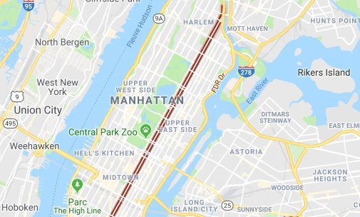
Manhattanhenge. The 34th Street (from Hudson to East River) is a major crosstown street in the New York City borough of Manhattan, connecting the Lincoln Tunnel and Queens-Midtown Tunnel.
Manhattanhenge. Basically, people in Manhattan are trapped in an island of tall buildings and sometimes can’t even see the sky really. It’s a brilliant moment when they can connect with the rest of the world and with the Earth.
It also has the advantage over other skyscraper cities because of a relatively clear view to the horizon down some of its streets.
For photographers and people taking an early evening stroll, it is just a beautiful effect of light.
└─► Business Insider
#manhattan#manhattanhenge#34thstreet#34th street#Hudson River Park#hudson river#lincoln tunnel#midtown#midtown manhattan#empire state building#Javits Center#herald square#manhattan solstice#neil degrasse tyson#american museum of natural history#stonehenge#astrophysicist#astronomy
421 notes
·
View notes
Photo
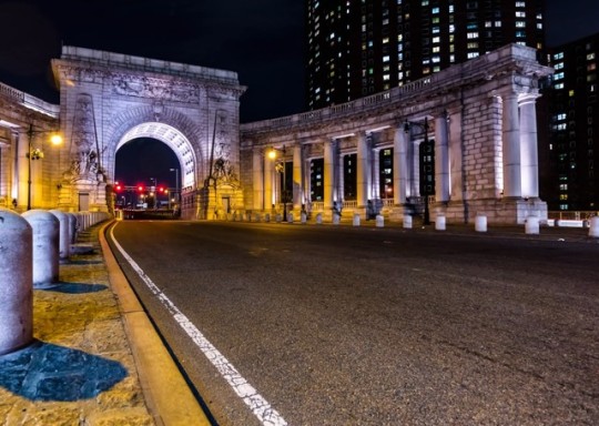
The triumphal arch and colonnade at the Manhattan Bridge entrance
The Manhattan Bridge Arch and Colonnade, located at the Manhattan entrance to the bridge, was built between 1910, the year after the opening of the brudge, and 1915, and was designed by Carrere & Hastings as a triumphal arch with flanking curved colonnades. The decoration includes pylons which were sculpted by Carl A. Heber and a frieze called “Buffalo Hunt” by Charles Rumsey. The arch and colonnade were repaired and restored in 2000.
└─► New York Architecture Images - Carrere and Hastings
#manhattan#east river#manhattan bridge and colonnade#dumbo archway#lower manhattan#Brooklyn Bridge#Brooklyn Bridge Park#the triumphal arch and colonnade#carrere & hastings#carl a. heber#buffalo hunt#charles rumsey#monumental gateway#canal street#bayard street#the bowery#China town#chinatown#columbus park pavilion#lower east side
664 notes
·
View notes
Video
A massive rainstorm rolled into New York City on Thursday afternoon, causing New Yorkers to send out of a flurry of posts on social media documenting the storm.
The storm caused the National Weather Service to issue a severe thunderstorm watch for Thursday afternoon and evening.
It looked like something out of a thriller movie.
└─► The Weather Channel
#new york city#climate change#climate science#climate activism#climateaction#climate anxiety#climatereality#climate denial#the weather channel#weather#the weather#rainstorm#thunderstorm#thunderspider#hurricane#hurricane windows#national weather service#weather change#weather conditions
1K notes
·
View notes
Video
Sight of the Statue of Liberty from Staten Island Ferry. If heaven is on earth…
More than a means of transportation, the Staten Island Ferry is an attraction unto itself. For no charge, visitors can take a 25-minute voyage by water from Lower Manhattan to Staten Island and take in the Statue of Liberty and the stunning vistas of New York Harbor and the Manhattan skyline. The ferry docks at the St. George Ferry Terminal, just a short bus ride from the Snug Harbor Cultural Center & Botanical Garden.
└─► The Staten Island Ferry
#new york city#manhattan#downtown#downtown manhattan#statue of liberty#lady liberty#liberty#liberty island#south manhattan#upper new york bay#lower new york bay#hudson river#staten island#staten island ferry#snug harbor cultural center#botanical garden#gustave eiffel#frédéric auguste bartholdi#edouard rené de laboulaye#manhattan skyline
831 notes
·
View notes
Photo


Look: no windows! the utterly magnificent AT&T long lines building in tribeca. This prime example of brutalist architecture was designed by john carl warnecke and completed in 1975.
The former AT&T Long Lines Building at 33 Thomas Street is a 550 foot (167.5 meter) tall skyscraper in the Borough of Manhattan. It stands on the east side of Church Street, between Thomas and Worth Streets, in the Civic Center neighborhood of New York City. The building is an example of the Brutalist architectural style with its flat concrete slab facade.
The NSA has operated a top-secret surveillance program out of iconic AT&T building… For many New Yorkers, 33 Thomas Street - known as the “Long Lines Building” - has been a source of mystery for years. It has been labeled one of the city’s weirdest…
└─► The NSA’s Spy Hub in New York, Hidden in Plain Sight - The Intercept
└─► NSA.gov
#manhattan#south manhattan#lower manhattan#downtown#downtown manhattan#at&t building#at&tat&t long lines building#titanpointe#john carl warnecke#ohn carl warnecke & associates#thomas street#33 thomas street#church street#worth street#civic center area#civic center district#manhattan civic center district#nsa#brutalist architectural style#nsa mass surveillance#tribeca#skyscraper#manhattan skysrapers#manhattan borough#elephone switching equipmen#telephone switching equipment#sixth avenue
349 notes
·
View notes
Photo
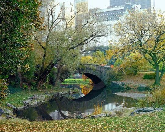
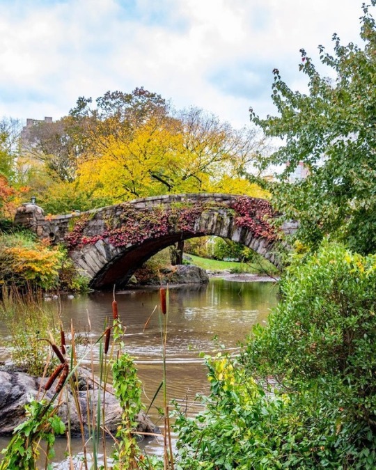
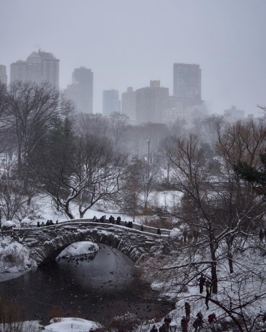
Bearing a striking resemblance to the Ponte di San Francesco in San Remo, Italy, Gapstow Bridge is yet another example of traditional architecture in Central Park.
Gapstow Bridge is one of the icons of Central Park, Manhattan in New York City. The first bridge was designed by Jacob Wrey Mould in 1874. The bridge was a wooden bridge with intricate cast iron railings. Due to excessive tear and wear, it was replaced by the present simple stone structure in 1896, by Howard & Caudwell. The schist stone span curves over the narrow neck of The Pond. Facing south, it offers a view of the city, the Plaza Hotel and other buildings. Gapstow stands 12 feet high, spans 44 feet of water, and stretches 76 feet in its full length. During the warm weather green foliage will cover the bridge.
It is most accessible by entering the Park at the corner of Central Park South and Fifth Avenue and following the path that runs to the right counter-clockwise along the perimeter of the Pond.
└─► The Complete Guide to New York’s Central Park
└─► Gapstow Bridge in Central Park
#manhattan#new york#manhattan borough#central park#gapstow bridge#ponte di san francesco#san remo#jacob wrey mould#brdige#central park bridge#wooden bridge#howard & caudwell#schist stone#the pond#central park pond#plaza hotel#the plaza hotel#central park south#5th avenue#fifth avenue#57 th street#new york’s central park
456 notes
·
View notes
Photo


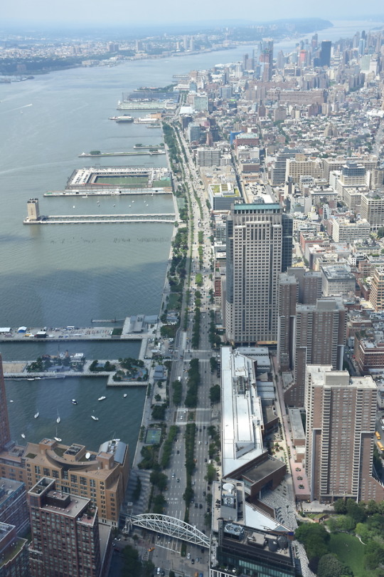
The Manhattan Waterfront Greenway is a foreshoreway for walking or cycling, 32 miles (51 km) long, around the island of Manhattan. The largest portions are operated by the New York City Department of Parks and Recreation. It is separated from motor traffic, and many sections also separate pedestrians from cyclists. There are three principal parts - the East, Harlem and Hudson River Greenways.
Though the Manhattan Waterfront Greenway does encompass some city streets, mostly it snakes for more than 28 miles along rivers, under bridges and through parks. . .
The Department of City Planning included a route around Manhattan in its 1993 master plan for 350 miles of recreation and commuting paths in all five boroughs. In 2002 Mayor Michael R. Bloomberg pledged to have the Manhattan loop built, and the city began stitching together existing pedestrian walkways, esplanades and city streets into a single route — in some areas paving connections and in others simply planting signs racetrack-shaped and green, with a five-leafed ivy motif pointing the way… .
The esplanade provides paths for biking, jogging, and skating, and the new park at Pier 15 offers elevated green spaces, waterfront dining, and spectacular views. For seasonal day trips, ferries to the Fort Tilden and Sandy Hook beaches are only steps away.
└─► The New York Times
└─► TimeOut New York
#manhattan#waterfront greenway#manhattan waterfront greenway#foreshoreway#island of manhattan#new york city department of parks and recreation#The Manhattan Waterfront Greenway#department of city planning#michael r. bloomberg#mayor Michael R. Bloomberg#hudson river#henry hudson#hudson square#henry hudson parkway#the palisades#new york passenger ship terminal#south ferry subway station#inwood hill park#east river#greenway Harlem#river park harlem#speedway dyckman street#square henry hudson
354 notes
·
View notes
Photo

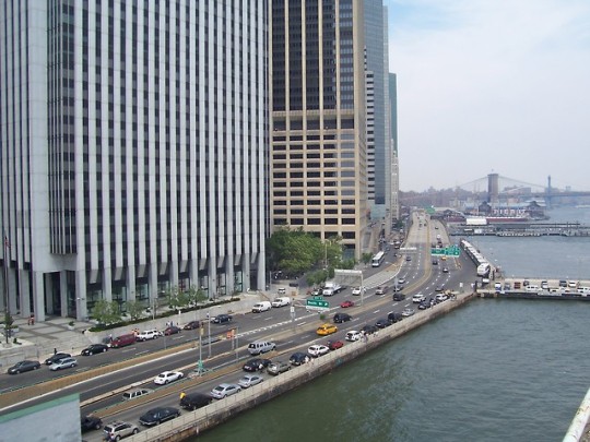

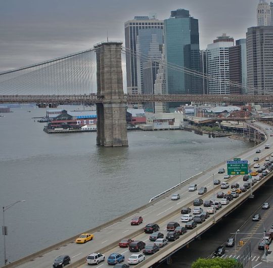
The FDR Drive (officially referred to as the Franklin D. Roosevelt East River Drive, and sometimes known as the FDR) is a 9.44-mile (15.19 km) freeway-standard parkway on the east side of borough of Manhattan. It starts just north of the Battery Park Underpass at South and Broad Streets and runs along the entire length of the East River, from the Battery Park Underpass under Battery Park – north of which it is the South Street Viaduct – north to 125th Street / Robert F. Kennedy Bridge / Willis Avenue Bridge interchange, where it becomes the Harlem River Drive. All of the FDR Drive is designated New York State Route 907L (NY 907L), an unsigned reference route.
The highway is mostly three lanes in each direction, with the exception of a small section underneath the Brooklyn Bridge where it is one lane in each direction and a section near the Queensboro Bridge interchange (exit 12) where there are only two lanes going northbound.
By law, the current weight limits on the FDR Drive from 23rd Street to the Harlem River Drive in both directions is posted 8,000 pounds (3,600 kg). Buses are not allowed to use the roadway north of 23rd Street, because of clearance and weight issues. All commercial vehicles (including trucks) are banned from all sections of the FDR Drive, except for a short section just north of the Battery Park Underpass where the northbound lanes temporarily merge with South Street. The FDR Drive features a mix of below-grade, at-grade, and elevated sections, as well as three partially covered tunnels.
└─► Untapped Cities - The Top 10 Secrets of the FDR Drive
└─► Franklin D. Roosevelt | Biography, Presidency, & Facts
#manhattan#east manhattan#east river#fdr#fdr drive#franklin d. roosevelt east river drive#freeway#battery park#borough of manhattan#battery park underpass#south street viaduct#robert f. kennedy bridge#willis avenue bridge#harlem River Drive#brooklyn#brooklyn bridge#franklin d. roosevelt#roosevelt island#roosevelt
330 notes
·
View notes
Photo


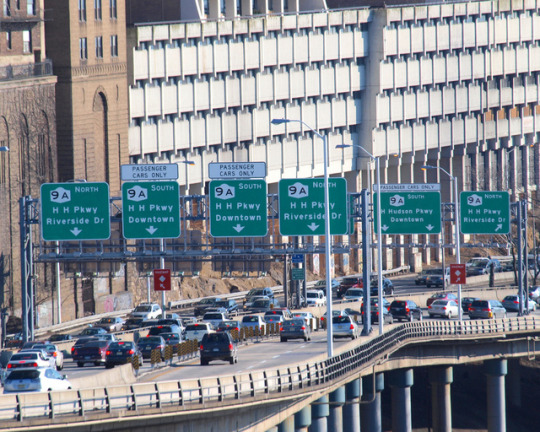

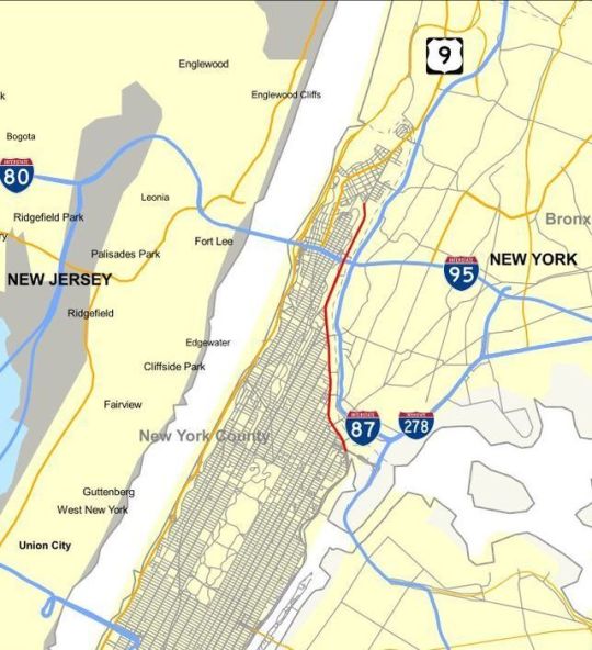
The Henry Hudson Parkway is an 11.05-mile (17.78 km) parkway in New York City. The southern terminus is at West 72nd Street in Manhattan, where the parkway continues south as the West Side Highway. It is often erroneously referred to as the West Side Highway throughout its entire course in Manhattan. The northern terminus is at the Bronx–Westchester county boundary, where it continues north as the Saw Mill River Parkway. All but the northernmost mile of the road is co-signed as New York State Route 9A (NY 9A). In addition, the entirety of the parkway is designated New York State Route 907V (NY 907V), an unsigned reference route.
└─►NYC Parks: Henry Hudson Parkway
└─► Henry Hudson | Biography & Facts | Britannica.com
#manhattan#Upper West Side#west manhattant#hudson river#Henry Hudson#henry hudson parkway#parkway#new york parkway#west side highway#northern terminus#Bronx–Westchester county#saw mill river parkway#New York State Route 907V#the henry hudson parkway
374 notes
·
View notes
Photo


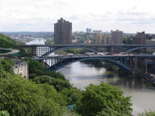
The Harlem River Drive is a 4.20-mile (6.76 km) long north–south parkway in the borough of Manhattan. It runs along the west bank of the Harlem River from the Triborough Bridge in East Harlem to 10th Avenue in Inwood, where the parkway ends and the road continues north as Dyckman Street. The portion of the Harlem River Drive from the Triborough Bridge to the Alexander Hamilton Bridge is a limited-access highway. South of the Triborough Bridge, the parkway continues toward lower Manhattan as FDR Drive. All of the Harlem River Drive is designated New York State Route 907P (NY 907P), an unsigned reference route.
└─► NYCRoads - Harlem River Drive
#harlem river drive#the harlem drive#harlem#manhattan#borough of manhattan#north–south parkway#harlem river#triborough bridge#east Harlem#dyckman street#fdr drive#route 907P#north manhattan#alexander hamilton bridge#highway#manhattan highway#east river
231 notes
·
View notes
Photo


There’s no better place to be on New Year’s Eve than New York. Watch the famous ball drop in Times Square, and then catch the pyrotechnics show in Prospect Park. Grand Army Plaza has live music, while the Steeplechase Plaza on Coney Island offers food, rides, and fun…
└─► Time Out : the best New Year’s Eve events in NYC
344 notes
·
View notes
Photo


56 Leonard Street is an 821 feet (250 m) tall, 57-story skyscraper on Leonard Street in Tribeca. The building was designed by the Swiss architecture firm Herzog & de Meuron, who describes the building as “houses stacked in the sky. It is the tallest structure in Tribeca.
The building has 145 condominium residences priced between US$3.5 million and US$50 million. Residences range in size from 1,418 to 6,400 square feet (131.7 to 594.6 m2) and include 2 to 5 bedrooms all with private outdoor spaces.
This skyscraper is one of New York City’s most distinct.
Dubbed the ”Jenga building“ for its standout design, this swanky Tribeca neighborhood high rise certainly stands out in the city’s famous skyline. But it’s the views from the interior that will really take your breath away.
“The most alluring addition to the downtown skyline in decades.” Justin Davidson (Architecture critique - New York Magazine)
└─► 56 Leonard Luxury Penthouses
└─► Iconic, New Luxury Condos
#manhattan#lower manhattan#downtown#downtown manhattan#skyscrapers#new york skyline#new york skyscrapers#56 Leonard Street#leonard street#swiss#swiss architecture#architecture firm#Herzog & de Meuron#condominium apartments#condominium apartments building#jenga building#izak senbahar#jenga game#leonard penthouse#luxury condos#56 Leonard Luxury Penthouses#tribeca#justin davidson
947 notes
·
View notes
Photo


One of may favorite time of year in NYC is at Christmas time. The magic of this time of year is almost indescribable.
Take a walk down any street in the city during December and you’ll be met with wreaths, Christmas trees, bells, bows, lights, everything. The stores really go all out, especially on 5th Ave, where famous displays from Saks 5th Avenue, Tiffany & Co, Bergdorf Goodman, and pretty much everywhere else can be enjoyed as you stroll along.
└─► Christmas Customs and Christmas Traditions
└─► The Peninsula: discover the Holiday Magic of NYC
#chistmas#christmas tree#christmas eve#christmas time#christmas magic#the magic of christmas#christmas bells#christmas lights#christmas crackers#carols#christmas cards#Christmas carols#christmas gifts#christmas pickle#christmas pudding#christmas presents#happy christmas#merry christmas#nicholas#santa#santa claus#snow#snowboard#holly#ivy#he holly and the ivy#the peninsula#new york peninsula#christmas traditions#Holiday Magic of NYC
538 notes
·
View notes
Video
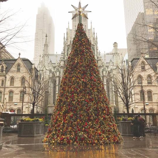
Christmas tree at Lotte Palace Hotel 455 Madison Avenue.
From The Lotte, you can admire the gothic spires of Saint Patrick’s Cathedral soar 330 feet above Fifth Avenue’s fashionable shopping district..
The New York Christmas starts, with the Macy’s Thanksgiving Day Parade at the end of November and the Christmas lights and window displays of the most famous cities in the Big Apple, such as Barneys, Tiffany & Co and Saks Fifth Avenue.
It’s almost Christmas and rather than the perfect and idyllic Christmas like the one shown on the ads every year, with the perfect family, the perfect gifts and the tree with its glass ornaments, yours is the real Christmas, your Christmas, the one with the long family lunches, the obligatory gifts, the blowout meals, the excuses to avoid certain get-togethers and of course, the passive-aggressive and critical comments all day long…
└─► Lotte New York Palace
└─► Rockfeller Center tree lighting
└─► Where to shop on Madison avenue
└─► St. Patrick’s Cathedral
▼ Madison avenue ▼

#christmas#christmas tree#christmas eve#lotte palace hotel#lotte palace#lotte palace christmas tree#madison avenue#455 Madison Avenue#saint patrick’s cathedral#fifth avenue#5th avenue#lotte new york palace#rockfeller center tree lighting#rockfeller center#christmas lights#barneys#tiffany & co#Fifth Avenue’s fashionable shopping#xmas#new york#new york city#new york city christmas#christmas gifts#christmas shopping#xmastime#xmasiscoming#merry xmas
562 notes
·
View notes
Photo


Brooklyn Bridge Park 334 Furman StreetBrooklyn, NY 11201
Stretching from the Manhattan Bridge down to Atlantic Avenue, this waterfront green space acts as a magnet for bikers, picnickers, kayakers, moviegoers and families out looking for a lovely place to stroll.
Brooklyn Bridge Park is an 85-acre (34 ha) park on the Brooklyn side of the East River in New York City. Designed by landscape architecture firm Michael Van Valkenburgh Associates, the park is located on a 1.3-mile (2.1 km) plot of land from Atlantic Avenue in the south, under the Brooklyn Heights Promenade and past the Brooklyn Bridge, to Jay Street north of the Manhattan Bridge. From north to south, the pier includes the preexisting Empire-Fulton Ferry and Main Street Parks, the historic Fulton Ferry Landing, and Piers 1–6, which contain various playgrounds and residential developments. The park also includes Empire Stores and the Tobacco Warehouse, two 19th-century structures, and is a part of the Brooklyn Waterfront Greenway, a series of parks and bike paths around Brooklyn.
└─► Official

Fir-trees & One World Trade Center from Brooklyn Bridge Park
Winter’s metaphors often include its stillness, its sense of silence and darkness, a season of hibernation, a season where everything dies a little. The falling snow is a “poem of the air,“ wrote Henry Wadsworth Longfellow, where the “troubled sky reveals the grief it feels.”
└─► Fascinating facts about One World Trade Center
#manhattan#manhattan bridge#lower manhattan#brooklyn#brooklyn borough#manhattan borough#fir-trees#christmas#christmas tree#one world trade center#brooklyn bridge park#manhattan bridgz#atlantic avenue#east river#michael van valkenburgh#michael van valkenburgh associates#brooklyn heights promenade#jay street#Empire–Fulton Ferry#Main Street Parks#fulton ferry landing#empire stores#tobacco warehouse#brooklyn waterfront greenway#parks and bike paths#henry wadsworth longfellow
719 notes
·
View notes
Photo
└─► Time Out New York: Thanksgiving in NYC guide
└─► The day after America's Thanksgiving: Get ready for Black Friday


▲ Macy’s Thanksgiving Day Parade at Columbus Circle - Central Park West - 8th avenue, Broadway avenue & W 59th st ▲
Thanksgiving Day is an annual national holiday in the United States and Canada celebrating the harvest and other blessings of the past year. In the US Thanksgiving is celebrated on the fourth Thursday of November while in Canada nearly one month and a half earlier (second Monday of October). Thanksgiving has deep roots in religious tradition, but nowadays it is primarily celebrated as a secular holiday.
Thanksgiving tradition began in early XVII century, but date and popularity varied between states. First nation-wide Thanksgiving was proclaimed on November 26, 1789 by George Washington. The contemporary date of fourth Thursday of November was set in 1941 by federal legislation.
└─► The 90th Annual Macy’s Thanksgiving Day Parade 2016
#manhattan#midtown manhattan#thanksgiving#thanksgiving turkey#macy's thanksgiving day parade#central park#central park west#thanksgiving day#59th street#columbus circle#christopher columbus#national holiday#fourth thursday of november#religious and cultural tradition#pumpkin#pumpkin pie#plymouth rock turkey#mashed potatoes#cranberry sauce#american indian heritage day#black friday#8th avenue#broadway avenue#57th street#w 59th st#midtown west#thanksgiving day parade#macy’s thanksgiving day parade#thanksgiving dinner etiquette
822 notes
·
View notes
Photo
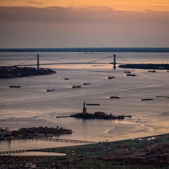
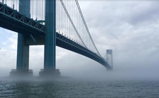
Last door before the ocean, the Verrazano–Narrows Bridge (sometimes called simply the Verrazano Bridge) is a double-decked suspension bridge in the U.S. state of New York that connects the New York City boroughs of Staten Island and Brooklyn. It spans the Narrows, a body of water connecting the relatively protected upper bay with the larger, wide open lower bay.
The bridge is named for the Florentine explorer Giovanni da Verrazzano, whose name is misspelled on the bridge, as well as for the Narrows. In 1524, while in the service of Francis I of France, Verrazzano became the first European to enter New York Harbor and the Hudson River. It has a central span of 4,260 feet (1,298 m) and was the longest suspension bridge in the world at the time of its completion in 1964, surpassing the Golden Gate Bridge by 60 feet, until it was in turn surpassed by 366 feet by the Humber Bridge in the United Kingdom in 1981. It has the eleventh longest main span in the world, while retaining its place as the longest bridge span in the Americas. Its massive towers can be seen throughout a good part of the New York metropolitan area, including from spots in all five boroughs of New York City and in New Jersey.
└─► Verrazano Bridge Opened to Traffic - The New York Times
└─► more on my Tumblr
#manhattan#New York City#new york#upper new york bay#the upper new york bay#lower bay#new york lower bay#verrazano–narrows bridge#verrazanobridge#verrazano bridge#verrazanonarrowsbridge#staten island#staten island ferry#brooklyn#borough of brooklyn#atlantic ocean#borough of staten island#andy hook#new jersey#port of new york an new jersey#port of new york#the queens#long island#double-decked#suspension bridge#giovanni da verrazzano
626 notes
·
View notes