#mapart
Text
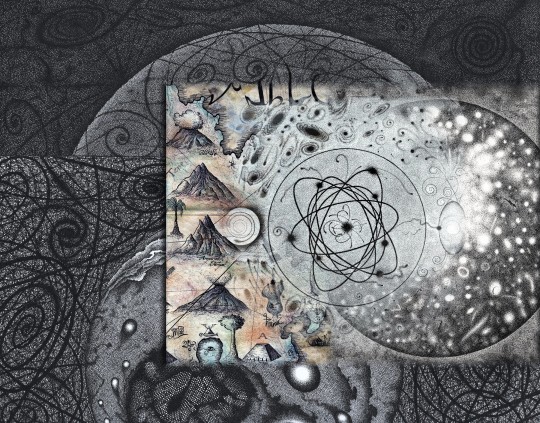
"Kosmische Karte: auf der Suche nach dem Ur-Atom"
51 notes
·
View notes
Text
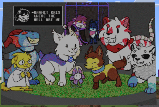
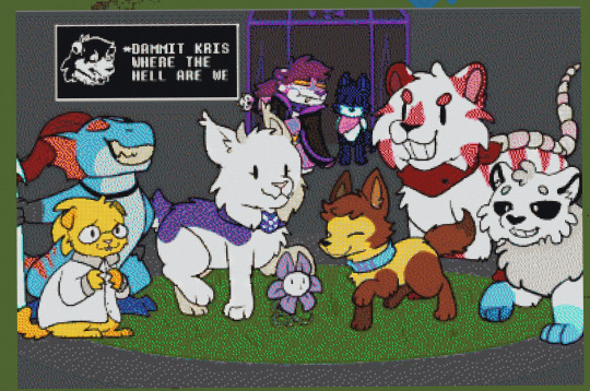
FINALLY
384x257 mapart of @pawtale, around 100,000 blocks, took around a month and a half.
Original image:

67 notes
·
View notes
Text
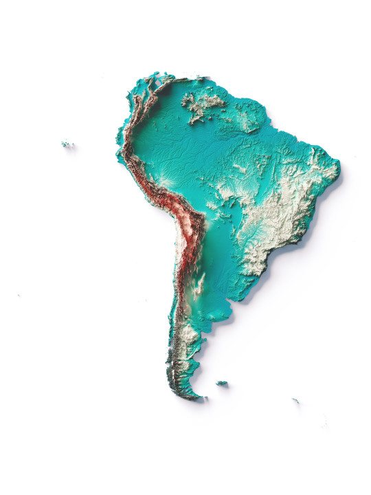
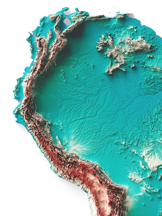
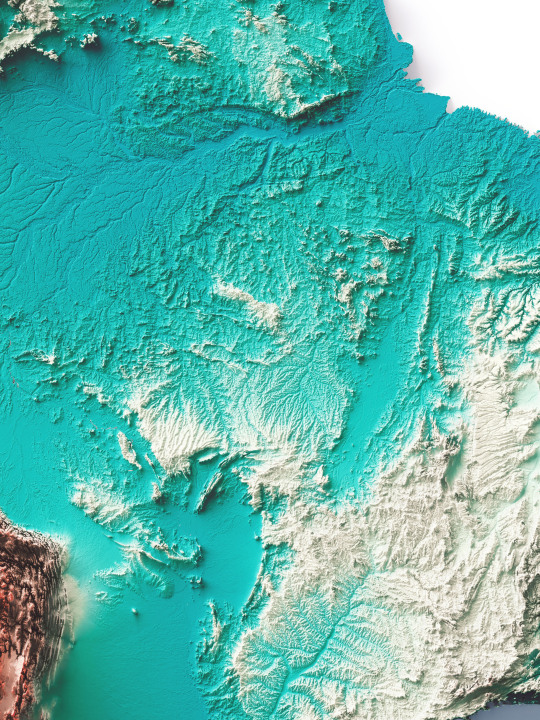
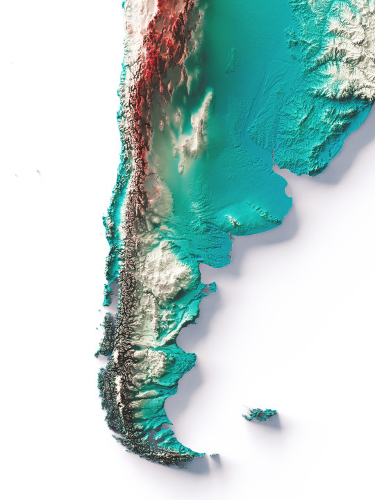
South America, elevation map on Spectral tint.
We have created four colour variants for this continent and would like this combination to become standard.
The red area shows the highest mountains, the Cordillera de los Andes, while the plains are indicated with the colour petrol blue.
If you like our work, want to see our daily updates (or want to say hello to our studio), consider to follow our Instagram or Twitter account. Otherwise if are interested in our prints or have a custom request check our shop.
#mapporn#dataviz#datavisualization#mapart#b3d#blender#qgis#cartography#maps#geography#reliefmaps#reliefmap#3dmapping#mapping#mapartwork#southamerica#southamericatrip#southamericatravel#brazil#braziltravel#argentina#argentinatravel#braziltrip#chile#chiletravel#chiletrip#argentinacampeon#perutrvel#uruguay🇺🇾
97 notes
·
View notes
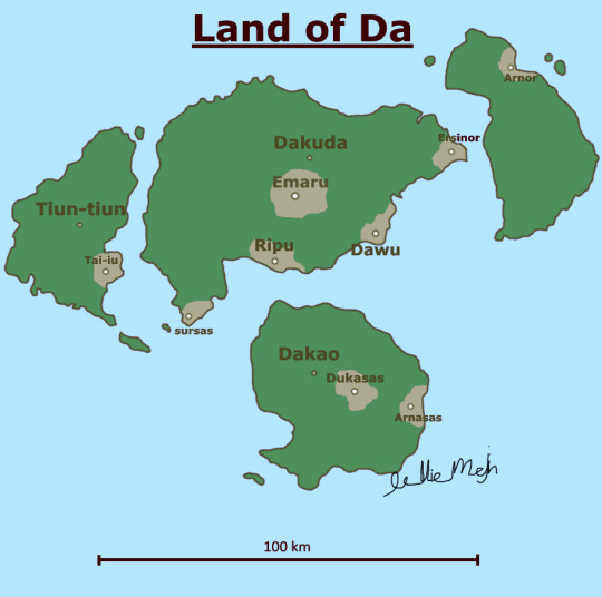
Text
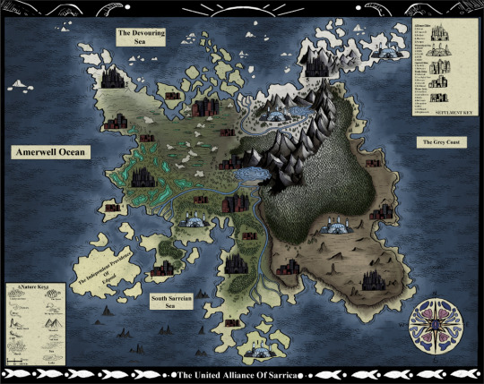


<<Repost of map from awhile ago with better formating and less wall of text>>
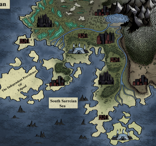
Map Of Sarrica, A harsh and mysterious land, surrounded by unknowable seas.
Its not perfect but its a map of my world setting which I am current and actively developing so there may be another version of this in the future, but for now I have worked on this long enough and have decided to post it. Basic world concept is a sort of mix between heavily industrial retro-futurism setting with lots of seaside town/dock inspired elements.
Basic world concept is a sort of mix between heavily industrial retro-futurism setting with lots of seaside town/dock inspired elements. I'm taking heavy visual inspiration from the 1930's but this may be prone to change
Sarrica is ruled over by a capitalist oligarchy headed by 5 extremely powerful and influence families that opperate from the centers of their heavily fortified , militarized walled cities. Said to be places of safety from the more harsh outside they are anything but, they are often extremely restrictive and suppressive of their people, built as imposing labyrinths- they are not made for people to live in, but to be used. It is by luck and their lack of interest that only the walled cities are under their complete dominion.
The only places with a little more freedom lay outside the walls and belong to what I'm gonna nickname as the "Market Union" they are far from perfect, as they are still often in the pockets of the walled cities families, they are also the capitals of Sarrica, and were there long before the walled cities, they tend to look and feel older, and usually handle their own,
working more communally when the walled cities families aren't sticking their fat fingers into them. The more remote towns and cities are more free of interference, but are dangerous and often harsh, but have their own strengths, usually mining, farming or lumber communities built up around a resource they head to the market cities to trade.
The only thing not related to Sarrica gov/people is the Prometheus bases, where are the centers of operations for the various wings of The Prometheus Organization, who work to study and contain anamolus events, such as rifts, they work with,, "outer" forces so they have more advanced technology than most and use it to help people when they can. Some of this is subject to change
but theres some of the basics, okay bye now thanks for reading!! Feel free to ask questions!
#salted sal#illustration#artists on tumblr#art#artwork#art tag#small artist#my art#digital art#artistsupport#artist on tumblr#worldbuilding#fakemap#mapart
9 notes
·
View notes
Text

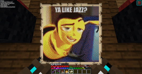
Mapart that Lectriz aka @dinowizards made on our server because they like to see the world suffer.
Join us at FarmersMarketMC.net! LGBTQ+ Friendly!
#minecraft#lgbtq#minecraft server#lgbt minecraft#minecraft lgbtq#lgbt#minecraft lgbt#minecraft lgbt server#mineblr#minecraft mapart#mapart#minecraft meme#ya like jazz#bee movie
9 notes
·
View notes
Text
BEHOLD
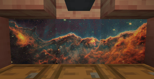
MY 3 PART MAPART OF THE COSMIC CLIFFS
4 notes
·
View notes
Text
While we countdown the days to #WonderCon I’m slowly releasing new art for you! My Map of #DerryMaine is now up on my webstore. A love letter to #StephenKing’s IT w/ lots of Easter Eggs to hunt for (not just the Ironworks). 🤡

https://dreamforger.com/products/map-of-derry-art-print
#NickKremenekArt #HorrorArt #fanart #DreamforgerStudios #art
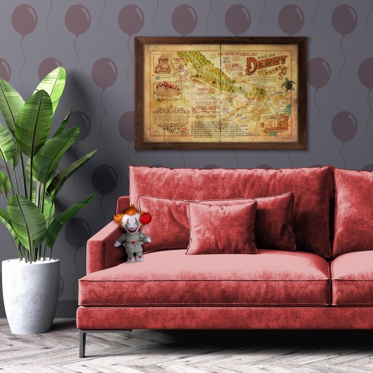
#illustration#artoftheday#pennywise#mapart#artforsale#popcultureart#losers club#beep beep richie#support artists
15 notes
·
View notes
Photo
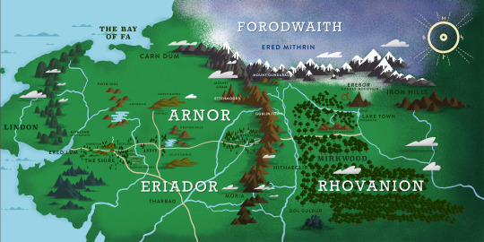
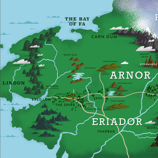
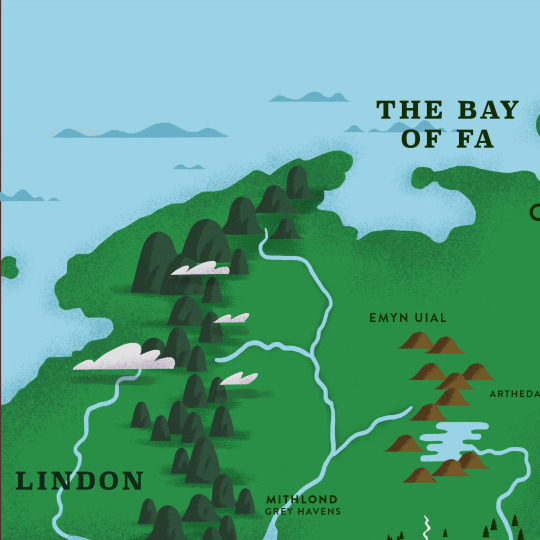
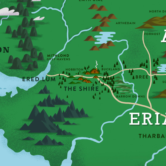
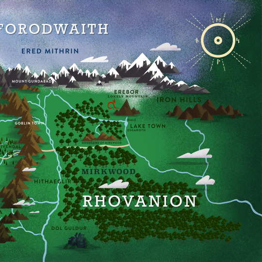
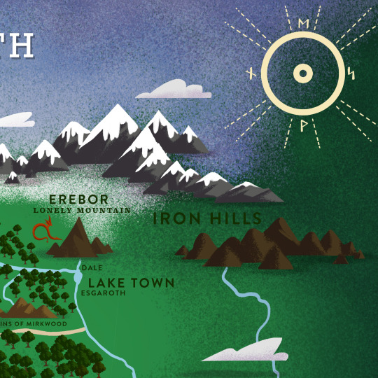
The Hobbit Book Map
#hobbit#the hobbit#jrrtolkien#middle earth#lotr fanart#lordoftherings#tolkie#fantasymaps#mapart#maps#fantasy books#bilbo#erebor
41 notes
·
View notes
Text
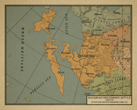
This is a map produced by the Salarian Order of Information, featured in the Book "Histories of the Crucible Vol. II" By Veetor Nar Zorah. A series of books describing the politics, cultures and histories of the people directly involved in the decades surrounding the Leviathan Golem invasion. Commonly referred to as 'The Crucible'. This map depicts the Batarian Hegemony before the invasion.
Batarians were originally a series of warring clans that did not advance past Bronze age technology before the Turian Imperium invaded in 580 BCE. The Turians were still functioning under an imperial government, and were expanding south. The Batarian clans were subjugated and integrated as second class citizens or slaves. During this time, slavery was still legal in the Imperium, and many Batarians were fed into this class structure.
With them the Turians brought the advancements of technology and magecraft inspired by the Fadegates. The ancient Leviathan structures that most civilizations were based around.
Eventually the Imperium met it’s end after conquering most of the Terminus Frontier, overextending and collapsing in on itself. Batarians gained their independence, and using the imperial administration format, continued a caste-based society, with slaves at the bottom. Soon after gaining and consolidating itself, the Hegemony became a belligerent force in Herah.
Batarian aggression provoked several crises in the surrounding lands. Historical enemies of the Turians in the north, near constant skirmishes and slaving raids occurred up until the Turian Unification wars in 300 BCE. The newly established Turian Hierarchy razed the Batarian city of Ka'hairal in response, ending any further direct attacks against them. This began the tradition of Batarians funding of pirate and bandit groups. The nation itself did not enter an open conflict again, instead waging proxy wars, benefiting from their success, while denying involvement after failure.
Batarian backed organizations raided and burned the Salarian colony of Erinle 1785 CE, destroyed the Asari colony of Tevia, and is credited with the slaughter of the Quarian 4th Great Caravan. That would spell the doom for Batarian power in the Perseus Sea. As the Massacre would instigate the forming of the Triumverate. Alarmed by this growing might on their boarder, the Hegemony sank immense wealth in coordinating all the different Pirate bands in the south seas to set the Triumverate coasts on fire.
The main thrust of the onslaught would be the invasions of the Triumverate city of Adas, which would act as a base of operations for the rest of the assault. It failed spectacularly, and ultimately ended with the destruction of the pirate fortress of Torfan. This in turn broke Batarian power in the Perseus sea.
Their influence would remain negligible until the Nazara Citadel Assault in 2179. In the chaos the Hegemony backed dozens of incursions in the Terminus Frontier. Allying itself with the Vorcha of Heshtok it managed to temporarily conquer Bekke, Kopanis, Parasc, and was on its way to assaulting Canton when the Leviathan Golem invasion, known as ‘The Crucible’ began.
The Hegemony was one of the first Nations hit, its response to the assault was uncoordinated. In 2163 CE, the Hegemony discovered the corpse of a Leviathan Golem near the city of Erszbat. Soon secret intensive studies of it began, in the hope of reclaiming the status of the past. This allowed the inherent magics of the Golem to indoctrinate prominent Batarian lords. So when the Golems invaded in 2181 CE, the indoctrinated rulers sabotaged Hegemony defenses, allowing the onslaught to easily conquer the Hegemony, crushing their armies and navy.
9 notes
·
View notes
Text
Immerse yourself in Hubert Roguski's transformative 'Metropolis' exhibition. Witness cityscapes recreated with a fresh, innovative twist.
#HubertRoguski #MetropolisExhibition #CityWood #ArtShow #LaserArtistry #ReimaginedMaps #ArtAddicts #CuttingEdgeArt #GeoCraft #ArtInWood #NewArtTrends #ArtisticRevolution #MappingArt #WoodArtMagic #NewAgeCartography #CityArtistry #ContemporaryArtTrends #DesignMuse #ArtSphere #ArtScene #ArtExpressions #BreakthroughArt #ArtisticJourney #ViralReels #ArtMuse #TrendingArt #SharedArt #FeaturedArt #ArtForToday
#mapart#thecitywood#hubertroguski#citywood#woodmap#woodenmap#anniversarygift#map#anniversarygifts#anniversary#exhibition#art exhibition#art show
2 notes
·
View notes
Text

"Weissagungskarte"
7 notes
·
View notes
Text

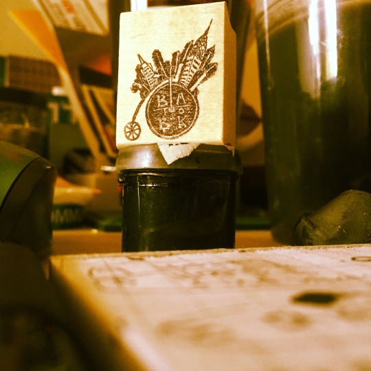


I made a custom stamp (the red blotch on each page) to sign the artwork
3 notes
·
View notes
Text
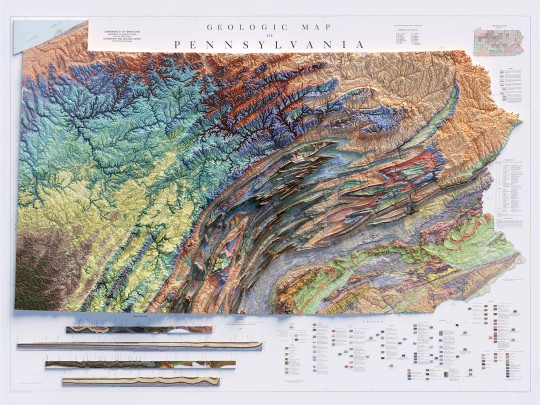
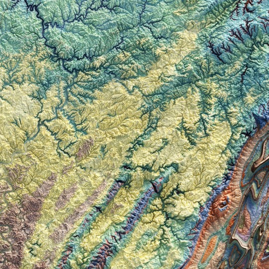
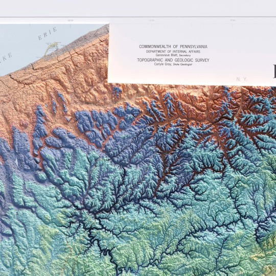
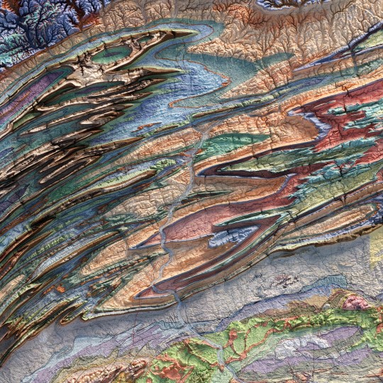
From the 1960s, a (restored) school geological map of Pennsylvania, obviously with shaded relief!
🗺️ 𝗠𝗔𝗣 𝗜𝗡𝗙𝗢
Geologic map of Pennsylvania, Topographic and Geologic Survey, Commonwealth of PA, 1960.
Source: David Rumsey Collection.
If you like our work, want to see our daily updates (or want to say hello to our studio), consider to follow our Instagram or Twitter account. Otherwise if are interested in our prints or have a custom request check our shop.
#Pennsylvania#pittsburgh#usmap#mapdesign#GeologyPA#VintageMap#PennsylvaniaHistory#ShadedRelief#GeologicHeritage#PAExploration#RockFormation#GeologicalTreasure#EarthScience#PennsylvaniaGeology#GeologicWonders#LandscapeHistory#GeologicalArt#ElevationData#GeologicMapping#BedrockGeology#NaturalHistory#GeospatialData#GeologicFeatures#MapArt#vizart
4 notes
·
View notes
Text
One of the maparts
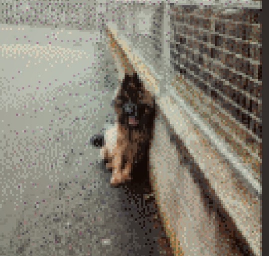
#artwork#computer generated image#pixelsorting#pets#pixel graphics#minecraft#mapart#meme#artists on tumblr#gif
2 notes
·
View notes
Text
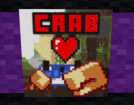
In honor of what we lost, Lectriz aka @dinowizards made a crab mapart. </3
WHY MOJANG
Join us at FarmersMarketMC.net! LGBTQ+ Friendly!
#minecraft#minecraft server#minecraft lgbt server#minecraft lgbtq#minecraft lgbt#mineblr#minecraft map#mapart#minecraft mapart#minecraft crab#minecraft mobvote
6 notes
·
View notes
Last Seen Blogs

onlinedeliveryblog75-blog
Online Delivery Blog

baylishh
🌻Bailey🌻
shinkonamikan
shin-kona-mikan

husiaprivate
You wouldn't notice when you step in near shore

llovelyq
L