#land management forester
Text
Most Common Gis Forester Jobs Salary
A geographic information device is a technology used in wood processing in forests, where geographic information about the forest is recorded in a laptop database. A GIS Forester is therefore responsible for managing all geostatistical systems, organizing and evaluating data stored in databases, and supporting land management and other forest-related business activities. As a result, you will enjoy working with data and want to learn more to understand what a GIS Forester Jobs Salary is.
Get help from experts. Forestry is a concept for all sectors. Also, are you looking for a company that offers decent welding jobs and wages? You can find excellent positions in the forestry industry. What do welders do? If you're a welder for a forest products company, you work in a fast-paced workplace. When repairing malfunctioning equipment, it may be necessary to intervene quickly to control the crisis. Call the Forest Service immediately. They provide vital process search aids and provide all relevant statistics.
#saw filer jobs salary#professional forester salary#land management forester#procurement forester jobs#industrial electrician salary
0 notes
Text
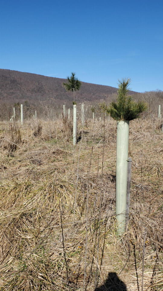
We planned in 2019 to have a 6-acre area of old pasture at Home Farm planted in trees. 2020 spring planting season came - with complications. The planting crews work from south to north to catch the early spring weather as it rolls up across the country. When they got to Maryland, they were 'stuck' and couldn't go any farther north; everything was shut down for Covid. My husband, who was a forester for the state at that time, got on the phone to anybody he could think of who could take the thousands of seedlings that had been scheduled to be planted in Pennsylvania and New York. We ended up planting quite a lot extra at Home Farm, too. This hill has cedar and pine regeneration lower down, but was quite treeless across the top. The new saplings, after four growing seasons, are poking out of the protective tree tubes, now, and flourishing.

In about ten years, it will be starting to look like a young forest, here. With a little luck.
20 notes
·
View notes
Text
The Nameless Trails
Tripods stand by tourists fanned across the valley floor,
A thousand shots in color, lots of orange and grey, and more.
(That is, unless, the sky won’t bless them with a cloudless day,)
The crowds look up and try their luck, for fire falls they pray.
Yosemite is fine to me, I’ll trek to Yellowstone,
Each park is grand, these wondrous lands are deservedly well-known.
Though swarmed by hoards of travelers, bored, we wait in miles of cars,
I’m glad I know the golden glow of sunsets lighting parks.
But have you seen the silver gleam of pools reflected light,
Dancing on a doe and fawn who never know your sight?
Among the stones and fields unknown, a fluttering of quails,
Have you heard the calling birds that sing on nameless trails?
Have you run in rising sun and held the rocks unturned?
This land is mine, and yours, from rhine to blackened forests burned.
The vast expanse and bold romance of the wild and free west
Out there awaits, beyond cow gates, with miles are we blessed.
Without a name or worldwide fame, alone I can meander.
No signs, no shops, vacant hilltops, a private, hidden grandeur.
Go and see the copse of trees, the unadvertised cattails,
Near you and know, the golden glow of sun on nameless trails.
#Poetry#My poetry#public lands#Bureau of Land Management#National Forest Service#Firefalls#Yosemite#Yellowstone#just go outside#National Parks are lovely but they're not the only#or best#places
42 notes
·
View notes
Text
Saw a post and just want to say: yeah ‘carbon offsets’ are usually bullshit. Sure some smaller land owners might actually be planting diverse native trees in proportion* to their carbon emissions. But as someone who’s worked with The Big Ones? Absolutely horseshit.
8/10 times they find a landowner with a crappy high graded beech-birch thicket and say to the owner: ‘Hey. We’ll pay you to not cut these trees you weren’t planning on/won’t be able to cut for a profit for the next 20-40 years anyway, and you’ll get a kickback.’ Ofc the owner says yes and the Big One can pat themselves on the back and show their stockholders ‘see we’re sooooo interested in reducing our carbon footprint’ when they’re straight up Doing Nothing.
When a Big One does engage in actual tree planting it is always a monoculture. There is not an economically viable way to plant the number of trees needed to proportionally offset their emissions* without it being a thoughtless monoculture without regard for site specificity and seedling survival rates.
How about instead of doing fuck all or wasting time and resources planting monocultures these big companies actually reduce their emissions instead of using their near infinite well of wealth to increase their emissions because they can always buy more crappy stands or pay a little more to plantation owners?
*Fun fact: we are barely at the cusp of carbon research being able to answer the long term + actual potential of carbon storage of different stands based on their age and species composition. We know that younger stands grow faster and therefore capture carbon at an increased rate compared to older stands. Realistically, a large older stand will capture comparative levels of carbon to a small younger stand. You just did a huge clear cut? Congrats that’s now a massive carbon sink you can get paid to ignore it the way you would be anyway for the next 50-60 years. Unsurprisingly this does information does not incentivize the conservation of old growth stands, because the most Carbon Efficient thing to do would be to cut all the old growth for timber (preserving it from decomposition and releasing carbon in most cases) and let new, young, fast growing forests replace them. Who cares about ecological nuance? We’re storing more carbon this way!
#ra speaks#personal#carbon credits#carbon capture#forestry#forests#environmentalism#people who read an ngo article on how Great carbon credits are: how dare you suggest this system could be abused!#and I’m just like. bro. babe. beloved. I’m going to take you up north and show you the ecologically devestated beech-birch thicket#that my undergrad used as tax write off bc the last land manager fucked over the schedule for a quick profit
18 notes
·
View notes
Text
A new Bureau of Land Management plan to open 40,000 acres of the Wayne National Forest to fracking for oil and gas looks almost identical to one a federal judge rejected in 2020. The public can comment on the plan in writing or during online meetings Monday and Tuesday.
Fossil fuel companies have targeted Ohio’s only national forest for years and in 2016 the BLM first attempted to auction off oil and gas leases in the Wayne. The new proposal, released in late March, is nearly identical to the fracking plan blocked in 2020 after conservation groups challenged it in federal court.
“It’s hugely disappointing that federal officials are sticking with this climate-destroying plan to sell off Ohio’s precious public lands to the oil and gas industry, even as flooding, wildfires and heat waves intensify with climate change,” said Wendy Park, a senior attorney at the Center for Biological Diversity. “Our government needs to prioritize people, wildlife and our climate over corporate profits and block fracking in the Wayne once and for all. Ohio residents have the chance to speak out over the next few weeks, and I hope land managers get an earful about this reckless fracking proposal.”
Fracking threatens the Wayne’s rivers, forests and endangered plants and animals ― the same things Congress intended to protect when it created the national forest in the 1930s.
“Fracking the Wayne National Forest would seriously jeopardize Ohio’s ability to fight climate change. This single oil and gas project threatens to generate enough greenhouse gas pollution to cancel out all of the Wayne’s carbon storage services for the next 30 years,” said Nathan Johnson, senior attorney with the Ohio Environmental Council. “Leasing the Wayne to the fossil fuel industry will scar this public forest and pollute our air with toxic chemicals. We should be doing everything we can to protect the public’s access to safe and beautiful public lands — especially in Ohio, where public land is in relatively short supply compared to so many other states.”
#us politics#enviromentalism#ecology#biden administration#fracking#bureau of land management#wayne national forest#ohio#oil industry#gas industry
4 notes
·
View notes
Text
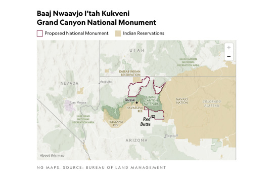
President Biden signed into existence the 917,618 acre Baaj Nwaavjo I’tah Kukveni – Ancestral Footprints of the Grand Canyon National Monument. The new national monument covers three tracts of land important to indigenous people in Arizona.
Nearly 5 million people visit the Grand Canyon each year, but few are aware that the site has been sacred to Indigenous peoples in the region since time immemorial — and that the national park designation of the region essentially kicked them off their homelands a century ago.
On Tuesday, President Biden recognized this history by designating the nearly one million-acre region including the Grand Canyon and its surrounding areas as the Baaj Nwaavjo I'tah Kukveni – Ancestral Footprints of the Grand Canyon National Monument in Arizona. The announcement follows a 15-year endeavor from a coalition of tribes to protect the region from uranium mining that has polluted the Colorado River. Baaj Nwaavjo means "where tribes roam" for the Havasupai Tribe, while I'tah Kukveni translates to "our ancestral footprints" in Hopi.
[ ... ]
Former President Barack Obama previously banned new uranium mines in the Grand Canyon area in 2012, but his policy was set to expire later this year. This is the fifth new national monument established by the Biden administration to protect the country's natural landscapes, following the designation of the Avi Kwa Ame national monument in Nevada earlier in 2023.
Republicans, of course, don't like it.
The new designation permanently protects the region from uranium mining, which Republican leaders were quick to oppose, sending a letter to Biden claiming that the protections created for the Grand Canyon would cause the U.S. to over-rely on foreign countries like Russia for uranium. However, The Guardian reported that advocates say the region only contains some 1% of the country's uranium reserves and that uranium is best mined elsewhere.
Contrary to what Republicans and far right media may claim, acreage for the Baaj Nwaavjo I’tah Kukveni was already in federal hands and does not represent a grab of state, tribal, or private lands. Amber Reimondo at Grand Canyon Trust writes...
National monument designations only apply to federally managed lands. The Baaj Nwaavjo I'tah Kukveni – Ancestral Footprints of the Grand Canyon National Monument designation thus adds a layer of protection to lands already managed by the U.S. Forest Service and U.S. Bureau of Land Management. No private, state, or tribal lands are included in the monument.
This added layer of protection is incredibly popular with the public. The monument has broad support across the Grand Canyon state.
[ ... ]
Recent polling shows that 75 percent of Arizona voters support designating lands immediately outside Grand Canyon National Park as a national monument to protect clean water supplies and Native American sites.
The three components of the Baaj Nwaavjo I'tah Kukveni are outlined in green on this map.

#baaj nwaavjo i'tah kukveni – ancestral footprints of the grand canyon national monument#indigenous rights#native americans#arizona#joe biden#us forest service#bureau of land management#conservation#the environment#uranium mining#colorado river
6 notes
·
View notes
Link
Excerpt from this press release from the Department of the Interior:
At a signing ceremony on Saturday, the Bureau of Land Management, the U.S. Forest Service, and the five Tribes of the Bears Ears Commission formalized and celebrated their partnership for co-management of the Bears Ears National Monument.
After signing the cooperative agreement formally recognizing their strong working relationship, the parties travelled to Highway 261 to unveil the Bears Ears National Monument sign(link is external), which includes insignias of the Hopi Tribe, Navajo Nation, Ute Mountain Ute Tribe, Ute Indian Tribe of the Uintah and Ouray Reservation, and the Pueblo of Zuni.
“Today, instead of being removed from a landscape to make way for a public park, we are being invited back to our ancestral homelands to help repair them and plan for a resilient future. We are being asked to apply our traditional knowledge to both the natural and human-caused ecological challenges, drought, erosion, visitation, etc.,” said Bears Ears Commission Co-Chair and Lieutenant Governor of Zuni Pueblo Carleton Bowekaty. “What can be a better avenue of restorative justice than giving Tribes the opportunity to participate in the management of lands their ancestors were removed from?”
To support the work that the five Tribes will perform under this agreement and through their representatives on the Bears Ears Commission, the BLM and U.S. Forest Service also announced that they will provide resources to each Tribe through a separate process.
On October 8, 2021, President Biden issued Proclamation 10285, which restored the Bears Ears National Monument, and recognized the importance of knowledge of Tribal Nations in managing the monument by re-constituting the Bears Ears Commission as established by President Obama in 2016, consisting of one elected officer each from the five Tribes. The BLM and the U.S. Forest Service jointly manage the monument and will prepare a management plan for federal lands within the 1.36 million-acre boundaries of the Bears Ears National Monument working cooperatively with the Tribal members of the Bears Ears Commission to protect and restore the monument objects and values.
#Bears Ears National Monument#Bureau of Land Management#BLM#US Forest Service#Native American tribes#Bears Ears Commission
74 notes
·
View notes
Text
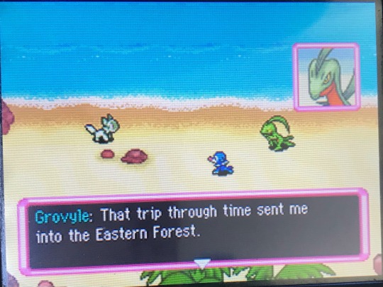
Love how they managed to bring all of the hypothetical time gear locations together like this
#it brings to question tho. how did dusknoir know about the eastern forest being a hypothetical place#i wonder if he managed to track down the place grovyle landed and was trying to give the guild hints?#cause i think he knew where a lot of time gears would be based on his research and tracking the og trio#echoed voice#pmd posting#sorry for being so slow with this btw djdjjdjf im gonna try to power through a lot of it today#… or at least the special episodes. i dont have my earbuds and im gonna be out all day and i like to use them for the last bit#so once im up to the hidden land ill probably swap to the special episodes
2 notes
·
View notes
Text
While I’m not interested in exploring it myself (maybe, maybe there could be some animals you need to avoid in the tree tops)—- the idea of terrestrial animals reproducing like plants do. Just letting off spores or whatever. Is it considered sex? What if you just wander into a cloud of someone’s spores? Is this a thing shlorpian-likers could explore? The general idea of releasing your sex cells into the wind or water or a hole dug in the ground— and someone else just coming along to get fertilized or fertilize your stuff—- is very different from the animal bump and grind. How would that effect their social psychology and cultural feelings around reproduction?
#solar opposites#speculative biology#(gloreal clantrees are kind of the opposite#(big ole plants that breathe and eat and send off wandering seeds to colonize at a reasonable distance from the main forest#(makes sense why they’re all primarily on the main continent#(only a few seeds manage to raft to the distant land and they end up very different from their homeland counterparts
18 notes
·
View notes
Text
Old Growth Forests: How Old is Old?
How Should We Define Old Growth?
Old growth and mature forests are the focus of a new executive order by President Biden, to identify and protect them as a part of climate conservation.
The order, signed Thursday, directs the National Forest Service (NFS) and the Bureau of Land Management (BLM) to define and inventory all mature and old growth forests on federal land, to identify the specific threats against them, and began…

View On WordPress
#Bureau of Land Management#deforestation#mature forests#national forest service#old growth forests#President Joe Biden
4 notes
·
View notes
Text
What I was taught growing up: Wild edible plants and animals were just so naturally abundant that the indigenous people of my area, namely western Washington state, didn't have to develop agriculture and could just easily forage/hunt for all their needs.
The first pebble in what would become a landslide: Native peoples practiced intentional fire, which kept the trees from growing over the camas praire.
The next: PNW native peoples intentionally planted and cultivated forest gardens, and we can still see the increase in biodiversity where these gardens were today.
The next: We have an oak prairie savanna ecosystem that was intentionally maintained via intentional fire (which they were banned from doing for like, 100 years and we're just now starting to do again), and this ecosystem is disappearing as Douglas firs spread, invasive species take over, and land is turned into European-style agricultural systems.
The Land Slide: Actually, the native peoples had a complex agricultural and food processing system that allowed them to meet all their needs throughout the year, including storing food for the long, wet, dark winter. They collected a wide variety of plant foods (along with the salmon, deer, and other animals they hunted), from seaweeds to roots to berries, and they also managed these food systems via not only burning, but pruning, weeding, planting, digging/tilling, selectively harvesting root crops so that smaller ones were left behind to grow and the biggest were left to reseed, and careful harvesting at particular times for each species that both ensured their perennial (!) crops would continue thriving and that harvest occurred at the best time for the best quality food. American settlers were willfully ignorant of the complex agricultural system, because being thus allowed them to claim the land wasn't being used. Native peoples were actively managing the ecosystem to produce their food, in a sustainable manner that increased biodiversity, thus benefiting not only themselves but other species as well.
So that's cool. If you want to read more, I suggest "Ancient Pathways, Ancestral Knowledge: Ethnobotany and Ecological Wisdom of Indigenous Peoples of Northwestern North America" by Nancy J. Turner
35K notes
·
View notes
Text
Identify, develop and implement targeted joint activities on sustainable land management and sustainable forest management, including through the development of transformative projects to achieve land degradation neutrality and sustainable forest management and through greater information exchange.
The UN Forum on Forests Secretariat, DESA and the UN Convention to Combat Desertification entered into a new Memorandum of Understanding (MoU) today, on the margins of the 78th session of the UN General Assembly. The MoU was signed by Ms. Juliette Biao, Director of the UNFF Secretariat, and Mr. Ibrahim Thiaw, Executive Secretary of the UNCCD. The key objectives of the MoU are to identify, develop and implement targeted joint activities on sustainable land management and sustainable forest management, including through the development of transformative projects to achieve land degradation neutrality and sustainable forest management and through greater information exchange.
Through this MoU, the two Secretariats aim to strengthen cooperation in the mobilization of financial resources for sustainable land and forest management and build strategic partnerships for implementation. This will include working together to raise awareness on the links between forests and sustainable land management, their contributions to climate change adaptation and mitigation and biodiversity conservation and on enhancing synergies between the Rio conventions and the UN Forum on Forests. The duration of the current MoU is for three years.
The UN Forum on Forests Secretariat and UN Convention to Combat Desertification Secretariat have a long history of working together as partners in the Collaborative Partnership on Forests (CPF), and the current MoU will serve to strengthen this existing collaboration in areas of mutual interest. Activities undertaken in implementing the MoU will support the achievement Sustainable Development Goals including SDG 15, the Global Forest Goals of the UN Strategic Plan for Forests 2030, Land Degradation Neutrality (LDN) targets, targets of the Kunming-Montreal global biodiversity framework and Paris Agreement of the UNFCCC amongst others.
#Collaborative Partnership on Forests (CPF)#mou#UN Strategic Plan for Forests 2030#Land Degradation Neutrality (LDN)#Kunming-Montreal global biodiversity framework#Paris Agreement#sdg15#Memorandum of Understanding (MoU)#unccd#unff#global forest goals#sustainable forest management
0 notes
Text
This New Park Gives Different Views of the Grand Canyon—with No Crowds
These sacred Indigenous lands in Arizona just got government protection. Here’s how to explore their hikes, wildlife, and impressive vistas.
— By Joe Yogerst | September 1, 2023

Red Butte, which the Havasupai people call Wii'i Gdwiisa (“Clenched Fist Mountain”), is one of many sacred Indigenous sites within Arizona’s new Baaj Nwaavjo I’tah Kukveni Grand Canyon National Monument. Named a national monument by President Joseph Biden in August 2023, the one-million-acre wilderness offers hiking, backcountry camping, and views of the Grand Canyon without the crowds. Photograph By Taylor McKinnon, Center For Biological Diversity
Grand Canyon National Park draws 4.7 million visitors a year to the northwest corner of Arizona to hike, camp, or watch wildlife. But most of them don’t realize that the lands within and surrounding the park are sacred to the region’s 12 Indigenous tribes, which include the Havasupai, Hopi, Navajo, and several bands of Paiute.
That changed on August 8 when President Joseph Biden signed a decree creating the Baaj Nwaavjo I’tah Kukveni—Ancestral Footprints of the Grand Canyon National Monument. Sprawling across more than 960,000 acres directly north and south of the national park, the new monument offers more rugged, less crowded recreation than its neighbor. It also provides a view of the landscape through Indigenous eyes.
“Baaj nwaavjo in Havasupai means ‘where the ancient people roamed,’” says Carletta Tilousi, coordinator of the Grand Canyon Tribal Coalition. “I’tah kukveni is the Hopi translation of ‘ancestral footsteps’. This reaffirms their creation stories.”
Here’s how the monument came to be, and how to explore it.
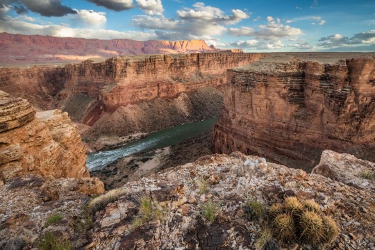
Baaj Nwaavjo I’tah Kukveni yields views of the Colorado River and Grand Canyon from a different perspective. Photograph By Amy S. Martin
How to Make a National Monument
It took two million years for the Grand Canyon itself to form and around 40 years for Baaj Nwaavjo I’tah Kukveni to become reality. “The protection for these lands is something the tribes have focused on since as far back as the 1980s,” says Amber Reimondo of the Grand Canyon Trust, a nonprofit devoted to preserving the region.
Many of these Indigenous people were expelled from their territory when Grand Canyon National Park was established in 1919. They campaigned for decades to receive stronger protection for their lands around the park, overcoming entities that wanted fewer legal obstacles to development and mining. After President Biden’s election in 2020, the 12 tribes formed a coalition which led to the lands receiving federal status.
Though the National Park Service oversees Grand Canyon National Park, monuments such as Baaj Nwaavjo I’tah Kukveni are run by the U.S. Forest Service (USFS) and the Bureau of Land Management (BLM). Monuments generally have fewer restrictions regarding their use (e.g., sometimes hunting or logging is allowed), as well as fewer facilities for visitors.
Fewer Amenities, Fewer Crowds
Like many national monuments, Baaj Nwaavjo I’tah Kukveni exudes raw nature. It has no bathrooms or visitor center; access is primarily via dirt roads or rough trails; you’ll need a four-wheel-drive to reach many sections of the park.
What it offers is solitude and peace amid the forests and grasslands of northern Arizona. You can gaze at the Grand Canyon without thousands of other people jostling for the same space, hike trails where yours are the only footsteps, and make camp at secluded spots. Plus you might encounter wildlife such as elk, black bear, mule deer, birds, or bison.
That solitude is also important to the Indigenous people. Tilousi says that when she visits the busy South Rim inside Grand Canyon National Park, “It’s very difficult for me to find a spot where I can offer prayers and offerings in a quiet way.” She feels that won’t be an issue in the off-the-beaten-track lands of the new monument.

Native plants including yucca flourish within Baaj Nwaavjo I'teh Kukveni National Monument. Photograph By Amy S. Martin
Exploring the Monument
The vast wilderness of Baaj Nwaavjo I’tah Kukveni is divided into three distinct sections or parcels, each with its own appeal.
The southernmost section, the Tusayan Ranger District/South Parcel, is the easiest to explore. Comprising 330,000 acres within the Kaibab National Forest, its pine woodlands and sagebrush prairie are accessible via Forest Service roads or Sections 35 through 37 of the Arizona Trail, an 800-mile hiking route stretching across the entire state.
The South Parcel also shows signs of human life, including the rusty hangar of the 1920s Red Butte Airfield and the 80-foot-tall Grandview Lookout Tower, which you can climb for views of the Colorado Plateau and the Grand Canyon.
The other sections of the monument, Kanab Plateau/Northwest Parcel and Rock House Valley/Northeast Parcel, are located beyond the North Rim section of Grand Canyon National Park.
“It's a big, remote wilderness,” says Michael Cravens, advocacy and conservation director of the Arizona Wildlife Federation. “I’ve never in my life been somewhere with night skies that spectacular.” But he cautions visitors “to be careful and prepared” for the extreme weather and topography. You can reach the northern parcels on BLM roads south of U.S. Highway 89A.

The vast House Rock Valley stretches through a portion of the new national monument. Photograph By Taylor McKinnon, Center For Biological Diversity
Stretched across the Kanab Plateau and Antelope Valley, the Kanab Plateau section has hiking routes through spectacular side canyons and to panoramic views such as Gunsight Point.
The Hack Trail drops down into the Kanab Creek Wilderness with its enormous red-rock canyons, a landscape almost as impressive as the Grand Canyon itself. Experienced hikers can continue down Kanab Creek to the Colorado River or along other trails to vertiginous overlooks along the North Rim.
Set beneath the Vermilion Cliffs National Monument, the Rock House Valley section of Baaj Nwaavjo I’tah Kukveni tumbles across sagebrush flats to the edge of Marble Canyon. Rugged hiking trails here include the Soap Creek Trail, which winds down from the Rapids/Badger Camp Overlook to a primitive campsite near the river.
Rough roads lead south to viewpoints for Rider Canyon, South Canyon, and other offshoots of the Grand Canyon. Here, you might even spot the North Rim’s resident bison herd, brought to the Arizona Strip in 1906 by Charles “Buffalo” Jones as part of efforts to save the species.
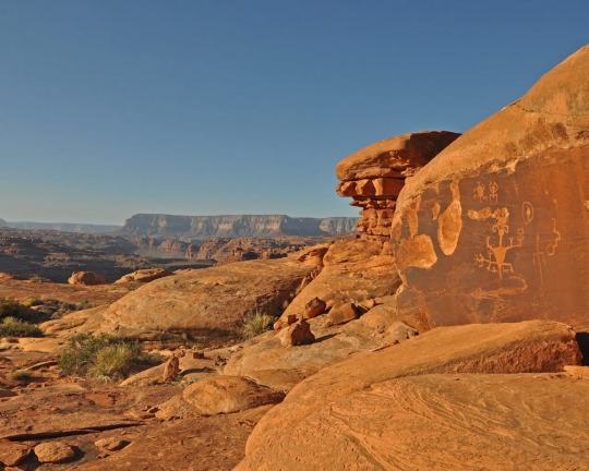
Ancient rock art can be spotted in the Kanab Creek Wilderness portion of Baaj Nwaavjo I’tah Kukveni National Monument. Photograph By Natpar Collection, Alamy Stock Photo

The Havasupai Indian Reservation in Arizona, which includes the Havasu Waterfall—part of the Havasupai Falls—is the current home of the Havasupai people. After the Grand Canyon became a national park, they were forcibly removed from their traditional homelands in the canyon and in nearby lands that will be part of the new national monument. Photograph By Mike Theiss National Geographic Image Collection
1 Million Acres of ‘Sacred’ Land Near Grand Canyon are Receiving New Protections! The designation of the land as a national monument, confirmed to National Geographic this week by the White House, will prevent new uranium mines and protect historically significant tribal lands.
#United States 🇺🇸 National Parks#New Park#Grand Canyan#Indigenous Lands#Arizona#Wildlife#Red Butte | Clenched Fist Mountain#Arizona | Baaj Nwaavjo I’tah Kukveni Grand Canyon National Monument#Center For Biological Diversity#President Joe Biden#Carletta Tilousi | Coordinator | Grand Canyon Tribal Coalition#Ancestral Footprints#Colorado River#Amber Reimondo | Grand Canyon Trust | Non-profit | Region Preservation#National Park Service#U.S. Forest Service (USFS) | The Bureau of Land Management (BLM).#Wildlife | Elk | Black Bear 🐻 | Mule | Deer 🦌 | Birds 🦅 | Bison 🦬#Hike Trails#Off-The-Beaten-Track Lands#Tusayan Ranger District | South Parcel#Kaibab National Forest 🌳#Colorado Plateau#Kanab Plateau/Northwest Parcel | Rock House Valley/Northeast Parcel#U.S. Highway 89A#Michael Cravens | Arizona Wildlife Federation#Kanab Plateau | Antelope Valley#Gunsight Point#Hack Trail#Vermilion Cliffs National Monument#Rock House Valley
1 note
·
View note
Text
"The Yurok will be the first Tribal nation to co-manage land with the National Park Service under a historic memorandum of understanding signed on Tuesday [March 19, 2024] by the tribe, Redwood national and state parks, and the non-profit Save the Redwoods League, according to news reports.
The Yurok tribe has seen a wave of successes in recent years, successfully campaigning for the removal of a series of dams on the Klamath River, where salmon once ran up to their territory, and with the signing of a new memorandum of understanding, the Yurok are set to reclaim more of what was theirs.
Save the Redwoods League bought a property containing these remarkable trees in 2013, and began working with the tribe to restore it, planting 50,000 native plants in the process. The location was within lands the Yurok once owned but were taken during the Gold Rush period.
Centuries passed, and by the time it was purchased it had been used as a lumber operation for 50 years, and the nearby Prairie Creek where the Yurok once harvested salmon had been buried.
Currently located on the fringe of Redwoods National and State Parks which receive over 1 million visitors every year and is a UNESCO Natural Heritage Site, the property has been renamed ‘O Rew, a Yurok word for the area.
“Today we acknowledge and celebrate the opportunity to return Indigenous guardianship to ‘O Rew and reimagine how millions of visitors from around the world experience the redwoods,” said Sam Hodder, president and CEO of Save the Redwoods League.
Having restored Prarie Creek and filled it with chinook and coho salmon, red-legged frogs, northwestern salamanders, waterfowl, and other species, the tribe has said they will build a traditional village site to showcase their culture, including redwood-plank huts, a sweat house, and a museum to contain many of the tribal artifacts they’ve recovered from museum collections.
Believing the giant trees sacred, they only use fallen trees to build their lodges.
“As the original stewards of this land, we look forward to working together with the Redwood national and state parks to manage it,” said Rosie Clayburn, the tribe’s cultural resources director.
It will add an additional mile of trails to the park system, and connect them with popular redwood groves as well as new interactive exhibits.
“This is a first-of-its-kind arrangement, where Tribal land is co-stewarded with a national park as its gateway to millions of visitors. This action will deepen the relationship between Tribes and the National Park Service,” said Redwoods National Park Superintendent Steve Mietz, adding that it would “heal the land while healing the relationships among all the people who inhabit this magnificent forest.”"
-via Good News Network, March 25, 2024
#indigenous#land back#indigenous issues#first nations#native american#indigenous peoples#yurok#yurok tribe#national parks service#national park#redwoods#california#trees#trees and forests#united states#good news#hope#indigenous land
5K notes
·
View notes
Text
The Bureau of Land Management recently announced that it will no longer allow the use of “cyanide bombs” on its lands. The M-44 devices are often used to protect livestock from animals like foxes or coyotes.
Several environmental groups lauded the decision, saying it makes public spaces safer for people and animals.
“Cyanide bombs” are baited, spring-loaded traps that release deadly poison into the air when triggered. Wildlife agents – often from the U.S. Department of Agriculture – usually set them to control predators, especially in remote areas.
M-44s killed more than 5,000 animals last year, according to the USDA, and were deployed in 10 states, including Wyoming, New Mexico, Colorado and Nevada.
Colette Adkins, Carnivore Conservation program director at the Center for Biological Diversity, said the devices are dangerous because of their indiscriminate nature.
“Anything that tugs on the spring-loaded device will be sprayed with this deadly poison, whether it's a kid, an endangered species or a target animal like a coyote. They really are just too dangerous to be used in public places,” she said.
This issue made national headlines in 2017 when a “cyanide bomb” killed a family pet and injured a boy in Idaho. Since then, several groups have been petitioning to end the use of M-44s on public lands.
With the BLM’s move, the devices are now banned from all lands administered by the U.S. Interior Department. Still, M-44s are allowed on U.S. Forest Service lands and in some states.
#let wolves live#ecology#enviromentalism#wolves#coyote#foxes#bureau of land management#US department of Agriculture#usda#bs culling#Cyanide bombs#us forest service
4 notes
·
View notes
Text
.
#I chickened out with macerating the d.eer skull#I left it out in the sun in a bucket for one day and like lots of progress#but it smelled so bad#and I live in a townhouse#I had it on the deck originally but I was afraid the neighbors were gonna be able to smell it#we don’t really have a backyard- it’s a little strip of land and then after that there’s a forested park behind the house#so I wasn’t sure I was gonna be able to bury it and was gonna have to macerate it on like the driveway or something#there’s a drought here and the ground was packed hard and there’s plants in the little backyard strip so there wasn’t much space#we’ve been having issues but my dad took notice and came out to help#found a spot just big enough that he managed to dig just deep enough to bury it#my only fear is coyotes are gonna smell it and dig it up#since it’s buried kinda shallow but I put some rocks on top to hopefully deter them and also to mark the spot#the bucket I was using smells so bad that I’m pretty sure I might need to toss it#which is bad cause I was using it to degrease and f.ox skull from the fox that died in my grandmas yard#gonna keep going with it for now since that can stay outside but we#second grossest thing I’ve ever smelled#first grosses was said f.ox#when it died it took my like four days to get over to my grandma’s to bury it#and it sat out and rotted in the hot sun for four days 🙃#decay is like something I’m used to smelling because again I live near a forest and go hiking all the time#but I forget just how bad it smells when you get up close and personal with it 🙃#it’s so much nicer when you find nature cleaned bones that just need to be sterilized 😞#excited for new bones tho- the f.ox probably needs another month to decrease and I’m not even gonna attempt to dig up the d.eer#until it starts to cool down here so like September or October#but new bones for the bone shelf#I gotta start using them for life drawing studies#I’m doing good with finding bones this year#f.ox skull x 2 - f.ox tooth x2 - d.eer skull x1 - d.eer tooth x1 + I bought a m.ink skull#thinking about going back once the d.eer carcass has completely decayed and grabbing a vertebrae or anything else with an interesting shape#there’s also the d.eer pelvis I left in the creek out back after I slipped and bashed my hand (which not broken but still healing yikes)
0 notes
Last Seen Blogs