#hotlum
Text
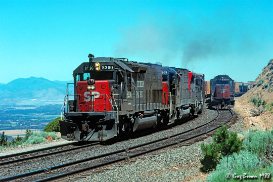
High noon at Hotlum
Far above the Shasta Valley, a westbound lumber drag rolls through Hotlum in July 1988. I wish I had better understood back then why savvy railfans spend summer hours between 11 am and 4 pm taking siestas in their cars, parked in the shade.
28 notes
·
View notes
Text

Mount Shasta in Winter
An astronaut aboard the International Space Station took this nadir photograph of Mount Shasta as the station passed over California. Mount Shasta is a 14,179-foot (4,233-meter) peak situated between Redding, California, and the Oregon-California border. Shasta’s slopes are at least partially snow-covered year-round. A more extensive snowpack during winter makes the mountain’s seven glaciers difficult to distinguish.
Mount Shasta is a stratovolcano constructed during four cone-building episodes, each separated by periods of less frequent central-vent eruptions (near the present peak) and flank-vent eruptions. Each of the four episodes of volcanism that formed Mount Shasta originated from separate eruptive centers, with two occurring approximately 9,000 to 10,000 years ago near Shastina and Hotlum Cone (located beneath Hotlum Glacier). Black Butte, located southwest of Mount Shasta (just off the bottom-left side of this image), was formed approximately 9,500 years ago when a series of flank-vent eruptions produced overlapping dacite domes.
Volcanic activity at Mount Shasta produced andesitic lava flows in addition to mudflows and block and ash flows. These collective eruption events produced 350 cubic kilometers (84 cubic miles) of material, making Shasta the largest volcano by volume within the greater Cascade Range.
Mixed conifer forests encircle the base of Mount Shasta and comprise part of the Shasta-Trinity National Forest. The effects of logging are visible as irregular patches of forested and barren land cover. Forest thinning is performed as an effort to make the forest more resilient to pests and decrease the danger of large fires. Silviculture projects within the region have sought to remove overly dense forest stands that are at risk of root rots or destructive crown fires.
Astronaut photograph ISS068-E-53629 was acquired on February 12, 2023, with a Nikon D5 digital camera using a focal length of 500 millimeters. The image was provided by the ISS Crew Earth Observations Facility and the Earth Science and Remote Sensing Unit at Johnson Space Center. The image was taken by a member of the Expedition 68 crew. It has been cropped and enhanced to improve contrast, and lens artifacts have been removed. The International Space Station Program supports the laboratory as part of the ISS National Lab to help astronauts take pictures of Earth that will be of the greatest value to scientists and the public and to make those images freely available on the Internet. Additional images taken by astronauts and cosmonauts can be viewed at the NASA/JSC Gateway to Astronaut Photography of Earth. Caption by Cadan Cummings, Jacobs, JETS II Contract at NASA-JSC.
5 notes
·
View notes
Video
Sacramento-bound Starlight at Elkhorn Slough por Nick Wolters
Por Flickr:
Two twenty-four year old General Electric P42DC's charge through Elkhorn Slough at forty-seven miles per hour with Amtrak Train 14. With the Salinas station stop well in the rear view mirror, AMTK 78 is in prime form seventy-four minutes before sunset. In late June, the Lava Fire in Siskiyou County scorched a vital trestle at Hotlum, CA on Union Pacific's Black Butte Subdivision. All rail movements along UP's "I-5 Corridor" were suspended for a few weeks including Amtrak's Coast Starlight service. Because of this, Amtrak was unable to operate over its entire route between Los Angeles and Seattle. The passenger carrier therefore opted to run Train 14 between LA and Sacramento, covering just 40% of its customary route mileage.
2 notes
·
View notes
Text
Mt Shasta Guide: The Best Routes, Views, and Experiences on the Mountain
The Problem: How to Plan a Trip to Mt Shasta?
Mt Shasta is a majestic mountain in Northern California that attracts thousands of visitors every year. Whether you are looking for a challenging climb, a scenic hike, a relaxing ski, or a spiritual retreat, Mt Shasta has something for everyone. But how do you plan a trip to Mt Shasta that suits your needs and preferences? How do you find the best routes, views, and experiences on the mountain with the help of a Mt Shasta guide?

There are many factors to consider when planning a trip to Mt Shasta, such as:
• The season: Mt Shasta has different weather conditions and activities depending on the time of the year. For example, the best time to climb the mountain is from May to July, when the snow is stable and the weather is mild. The best time to ski the mountain is from December to April when the snow is abundant and the slopes are uncrowded. The best time to enjoy the fall colours and the spring wildflowers is from September to November and from March to May, respectively.
• The route: Mt Shasta has many routes to choose from, ranging from easy to difficult, from short to long, from south to north, and from glacier to non-glacier. Some of the most popular routes are Avalanche Gulch, West Face, Casaval Ridge, Hotlum-Bolam Ridge, and Clear Creek. Each route has its advantages and disadvantages, such as the scenery, the difficulty, the distance, the elevation gain, the permits, and the guides.
• The view: Mt Shasta offers stunning views of the surrounding landscape, such as the Castle Crags, the Trinity Alps, the Klamath Mountains, and the Shasta Valley. Some of the best viewpoints are Lake Siskiyou, Bunny Flat, Highway 5 Turnout, Highway 97, and Castle Crags State Park. Each viewpoint has its perspective and distance from the mountain, as well as its accessibility and amenities.
• The experience: Mt Shasta is more than just a mountain, it is a spiritual energy vortex that connects you with the healing power of nature and yourself. Many people come to Mt Shasta to experience the sacred sites, the vortexes, the portals, and the crystals that are said to enhance your intuition, your creativity, your awareness, and your joy. Some of the best places to experience the spiritual side of Mt Shasta are Panther Meadow, Ascension Rock, Headwaters Spring, Telos Portal, and Venusian Portal.
Here are some of the best routes, views, and experiences on the mountain, according to Mt Shasta guides :
• Avalanche Gulch: This is the most popular and accessible route to the summit of Mt Shasta, suitable for beginners and intermediate climbers. The route starts at the Bunny Flat trailhead, and ascends through a forest, a meadow, and a snowfield, before reaching the steep and icy slope of Avalanche Gulch. The route offers spectacular views of the surrounding mountains, valleys, and lakes, as well as the chance to see the sunrise from the summit.
• Clear Creek: This is the easiest and least crowded route to the summit of Mt Shasta, suitable for novice and experienced climbers. The route starts at the Clear Creek trailhead, and follows a gentle and scenic trail along the east side of the mountain, passing by springs, waterfalls, and meadows, before reaching the final rocky ridge to the summit. The route offers stunning views of the Shasta Valley, the Trinity Alps, and the Lassen Peak.
• Casaval Ridge: This is the most challenging and rewarding route to the summit of Mt Shasta, suitable for advanced and expert climbers. The route starts at the Bunny Flat trailhead, and climbs up the west face of the mountain, following a narrow and exposed ridge of rock and ice, before reaching the summit plateau. The route offers breathtaking views of the mountain's features, such as the Red Banks, the Konwakiton Glacier, and the Misery Hill.
• Mt Shasta Vortex: This is a unique and mystical experience on the mountain, suitable for anyone interested in the spiritual aspect of Mt Shasta. The Mt Shasta vortex is a powerful energy field that surrounds the mountain and is said to enhance healing, intuition, and manifestation. The Mt Shasta vortex can be accessed from various locations on the mountain, such as the Panther Meadow, the Upper Sacramento River, and the Headwaters Spring. The Mt Shasta vortex offers a chance to connect with the mountain's spirit, as well as the ancient civilizations and beings that are believed to inhabit it.
• Mount Shasta Spiritual: This is a holistic and transformative experience on the mountain, suitable for anyone who is looking for personal growth and enlightenment. Mount Shasta spiritual is a combination of meditation, yoga, hiking, and retreat, that helps you align with your true self and purpose. Mount Shasta Spiritual can be customized according to your needs and preferences and can be guided by experienced and certified Mt Shasta tour guides. Mount Shasta spiritual offers an opportunity to discover the beauty and wisdom of Mt Shasta, as well as yourself.

The Solution: Hire a Mt Shasta Guide or Tour Operator
One of the best ways to plan a trip to Mt Shasta that meets your expectations and goals is to hire a Mt Shasta guide or tour operator. A Mt Shasta tour guide can help you with:
• Choosing the best route, view, and experience for you, based on your skill level, your interest, your budget, and your availability.
• Providing you with the necessary equipment, transportation, accommodation, food, and permits for your trip.
• Guiding you safely and professionally on the mountain, teaching you the skills and techniques, and sharing with you the history and the lore of the mountain.
• Connecting you with the energy and the spirit of the mountain, facilitating your meditation and your healing, and introducing you to your star family and your higher self.
There are many Mt Shasta guides and tour operators to choose from, each with its own style and speciality. Some of the most reputable and experienced ones are:
• Shasta Mountain Guides: They are the original and the largest guide service on Mt Shasta, specializing in mountaineering, backcountry skiing, rock climbing, and custom trips. They have been operating since 1982 and have a team of certified and passionate guides.
The Conclusion: Enjoy Your Trip to Mt Shasta!
Mt Shasta is a wonderful destination for anyone who loves nature, adventure, and spirituality. By hiring a Mt Shasta guide or tour operator, you can make the most of your trip and have a memorable and meaningful experience on the mountain. Whether you want to climb, ski, hike, or meditate, Mt Shasta has something for you. So, what are you waiting for? Book your trip to Mt Shasta today and enjoy the best routes, views, and experiences on the mountain!
#mount shasta portal#mtshastatour#mt shasta vortex#mtshastatourguide#mt shasta#mount shasta retreat#mtshastaguide#mt shasta spiritual#mtshastaretreat#mt shasta guide
1 note
·
View note
Text
Mount Shasta—Reality or Hoax? has been published on Elaine Webster - http://elainewebster.com/mount-shasta-reality-or-hoax/
New Post has been published on http://elainewebster.com/mount-shasta-reality-or-hoax/
Mount Shasta—Reality or Hoax?
Mount Shasta—Reality or Hoax?
(Shared from ‘Mu the Motherland‘)
Mount Shasta is a dormant volcano rising 14,179 feet in the Cascade Range of Northern California. The mountain is composed of four major volcanic cones built of layers or strata—each one created in its own eruptive period and overlapping with the others. There is a fifth cone, the Red Fir Cone, which outcrops lower on the mountain at 6340 feet and is often referred to as ‘Ancestral Mt. Shasta’ with rocks dated back about 590,000 years. (Most of what can be seen is less than 200,000 years old.) In comparison, the Shastina cone is only about 9700 years old and the last eruption was about 200 years ago from the Hotlum cone.
Image Source: College of the Siskiyous Library
The Cascade Range is part of “The Ring of Fire”, a chain of volcanic arc and trenches that border tectonic plates, so it’s no wonder that those that are sensitive to earth energies feel an intensity in this area. It is also not unusual for Native Americans to gravitate towards these energies. In fact, Shasta is a modernized spelling of “Sastise” the name used by Klamath Indians to describe an enemy tribe on the other side of the mountain; suggesting that they regarded the peak both as protection and a power source. The mountain was first summited in 1854 by Elias Davisson Pierce and party. Author Joaquin Miller spent four years in the area and John Muir survived an overnight snowstorm on the summit in 1875. Did any of these people, see or hear anything unusual? If they did, they didn’t report on it. However, advance to 1987 and Shasta was labeled a power point site for the Harmonic Convergence—the first synchronized peace meditation. Many consider the mountain to be one of the Seven Sacred Mountains of the World and Native Americans consider the area to be a place of balance between earth and the universe.
So, where did all the speculation begin about mystic temples hidden within the mountain and the advanced Lemurian civilization that is believed to live there? Well, it started with a teenager—a resident of Yreka—Frederick Spenser Oliver and his book ‘A Dweller on Two Planets’. Oliver wrote about mystical beings, sacred brotherhoods, temples, mysterious lights, and spaceships, but he insisted that he was not the author, but was channeled by ‘Phylos the Thibetan’. Oliver died at the young age of 33 and the book was published posthumously in 1905 by his mother and a group of friends.
Then, the ball seems to have been picked up again in 1931 when Wishar Spenle Cerve (pseudonym of Harvey Spencer Lewis) wrote and published through the Rosicrucian Order, ‘Lemuria, The Lost Continent of the Pacific: The Mystery People of Mount Shasta’. Cerve wrote that Lemurians were tall, graceful, and agile, with larger heads and much larger foreheads than average humans. If you peruse the local bookshops you will come across many accounts of Lemurians coming into town for supplies, often paying with gold nuggets. It was these stories that spurred the metaphysical tourism that is still prevalent today.
In 1934 author Guy Warren Ballard (pen name Godfre Ray King) wrote a memoir, ‘Unveiled Mysteries’, describing his meeting with “Saint Germain” on Mount Shasta. Yes, this is the same Saint Germain who worked at the Court of France during the French Revolution. His wife, Edna (after her husband’s death in 1940) continued to publish information about these encounters for the “I AM” movement and the group she formed continues to visit Mount Shasta.
There is so much written, filmed, and presented about Mount Shasta—the list of information is endless and easily accessed on-line. However, the one account that struck me as valid and unexplainable is the widely reported incident of a 3-year-old boy. In September 2011, a 3-year-old-boy and his dog wandered off from Fowler’s Campground at McCloud Falls, which is down the hill from Shasta sparking a desperate search of the area. The dog was found, wet and cold, but alive near some rapids. The search continued on the assumption the toddler might have been swept away in the rapids. Local news covered the search and the boy was found. However, his rescue came with an interesting story of being captured by a robot and taken to a creepy place. He described a cave and a woman, a grandmother, who told him he was from outer space and he was placed in his mother’s womb. This same woman took the boy back to the river and told him to wait for the searchers, which he did and was found. Most people dismiss the story as an over-active imagination of a small boy. However, it’s interesting that the dog was found first, alone, and the boy appeared later. Hmmm.
Finally, Pluto’s Cave, north of the mountain was prehistorically occupied by Native Americans and after the gold rush, secret societies conducted initiations and rituals there. Today many believe that it is a portal into Inner Earth and an underground secret city. The cave is managed by Klamath National Forest and is a lava tube that can be hiked into for approximated 1200 feet. The cave itself is larger than those found in the Hawaiian Islands. There are multiple lava flows visible in the cave walls. Most expert on the supernatural nature of Shasta and these tubes is author, Dustin Naef, who says that numerous hikers have reported seeing people literally walk into the rocks walls and disappear, presumably to enter the Hollow Earth and possibly the secret city of “Telos”.
Critics and skeptics argue that the Lemurian legend and the idea of an underground city beneath Mount Shasta are nothing more than imaginative folklore and unsubstantiated claims. They point out the lack of concrete evidence and scientific support for these beliefs. Skeptics argue that the stories surrounding the Lemurians and the Subterranean City of Mount Shasta are primarily based on subjective experiences, personal anecdotes, and channeled information, which are difficult to verify or validate.
Despite the lack of empirical evidence, the allure of the Lemurian legend and the Subterranean City of Mount Shasta persists. For believers, the stories offer a sense of wonder, hope, and spiritual inspiration. They find solace in the idea that there may be a hidden realm of enlightenment and higher consciousness accessible to those who seek it. The myth of the Lemurians and Mount Shasta also serves as a metaphorical representation of humanity’s longing for a more harmonious and spiritually connected existence. One thing that is undeniable is that Mount Shasta exudes power—physical and spiritual power. How each of us use nature’s power is an individual preference, but it will not and cannot be denied.
Additional Reference Source:
College of the Siskiyous Library
Mount Shasta Fact Sheet
0 notes
Photo

Mountaineering definitely has its perks Heres Mount Shasta from the Hotlum Glacier
2 notes
·
View notes
Photo
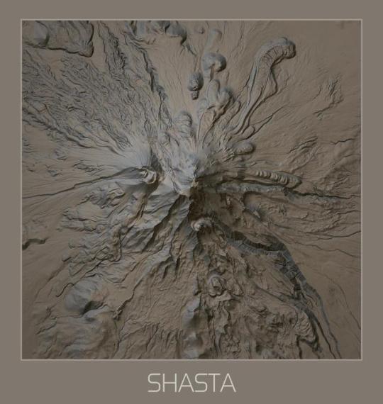
Mount Shasta, California - created using 1 meter Lidar data captured by the USGS.
by Bbrhuft:
Created in QGIS using three different layers; Combined Hillshading (via SAGA GIS), normal Hillshading (via GDAL) and themed topography that subtly lighten higher altitudes. Data is 1 meter Lidar from the USGS as described below...
The most voluminous of the Cascade volcanoes, northern California’s Mount Shasta, is a massive compound stratovolcano composed of at least four main edifices constructed over a period of at least 590,000 years. An ancestral Shasta volcano was destroyed by Earth’s largest known Quaternary subaerial debris avalanche, which filled Shasta Valley, northwest of the volcano. The Hotlum cone, forming the present summit, the Shastina lava dome complex, and the Black Butte lava dome on the southwest flank, were constructed during the early Holocene.
As part of the American Recovery and Reinvestment Act (ARRA) of 2009, the U.S. Geological Survey was awarded funding for high-precision airborne lidar (light detection and ranging) data collection at several volcanoes in the Cascade Range. Data collection was arranged by the Oregon Lidar Consortium, administered by the Oregon Department of Geology and Mineral Industries (DOGAMI). The Oregon Lidar Consortium contracted with Watershed Sciences, Inc., to collect 1,220 square km of high-precision airborne lidar data. These data provide a digital map of the ground surface beneath forest cover with horizontal resolution of 1 m (average of 1.82 ground laser returns per square meter) and estimated vertical accuracy of ±4 centimeters (1 sigma), and horizontal accuracies of ±1.5 centimeters. These data will contribute to monitoring and description of natural hazards, the study of regional geology and volcanic landforms, and analysis of landscape modification during and after the next volcanic eruption at Mount Shasta.
Ref.:
Digital topographic data based on lidar survey of Mount Shasta Volcano, California, July–September 2010.
131 notes
·
View notes
Photo
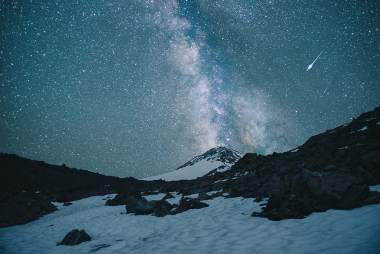
Mountaineering definitely has its perks. Here's Mount Shasta from the Hotlum Glacier. [OC][1920x1080]
2 notes
·
View notes
Video
flickr
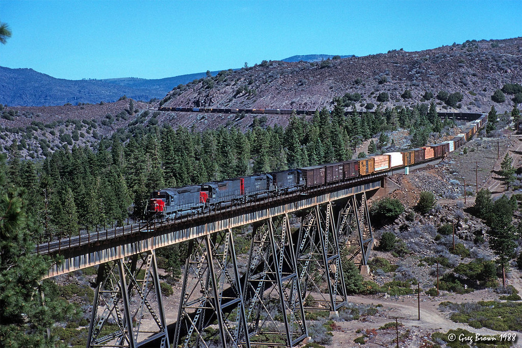
Dry Canyon Daily Double (2 of 2) by Greg Brown
Via Flickr:
Here are shots from each end of Dry Canyon Viaduct near Hotlum on the Black Butte Subdivision. In March 1988, an EURGM crosses the structure. If the Modoc Line had been open for through traffic at the time, this train would have been closing in on Alturas.
30 notes
·
View notes
Text
I just now discovered these interesting facts about the big volcano: In 2002, scientists made the first detailed survey of Mount Shasta's glaciers in 50 years. They found that seven of the glaciers have grown over the period 1951–2002, with the Hotlum and Wintun Glaciers nearly doubling, the Bolam Glacier increasing by half, and the Whitney and Konwakiton Glaciers growing by a third.
Ice Age anyone?
0 notes
Quote
The elements were a reminder that man is not always a welcome visitor in a kingdom he cannot control.
Fred Beckey on his ascent of Shasta’s Hotlum Glacier
0 notes
Photo

Mountaineering definitely has its perks. Here's Mount Shasta from the Hotlum Glacier. [OC][1920x1080] - Eminence
0 notes
Photo

Mountaineering definitely has its perks. Here's Mount Shasta from the Hotlum Glacier. [OC][1920x1080] by alandizzle
0 notes
Photo

Mountaineering definitely has its perks. Here's Mount Shasta from the Hotlum Glacier. [OC][1920x1080] via /r/EarthPorn http://ift.tt/2jEbOKT
0 notes
Photo

Mountaineering definitely has its perks. Here's Mount Shasta from the Hotlum Glacier. [OC][1920x1080] via /r/EarthPorn https://www.reddit.com/r/EarthPorn/comments/5rsh3r/mountaineering_definitely_has_its_perks_heres/?utm_source=ifttt
0 notes
Last Seen Blogs

urmibhatt
Urmi Bhatt

thepastisalreadywritten
The Past is Already Written

fabianvalencia561
The corrupted au (ttte) :D

florically-blog
Breathe

thegildedplain
The Gilded Plain