#cartographycommunity
Text
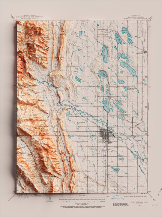
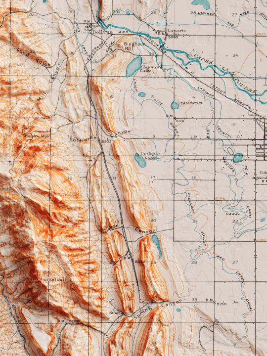
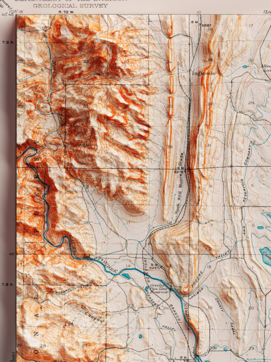
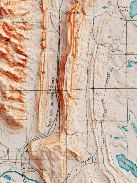
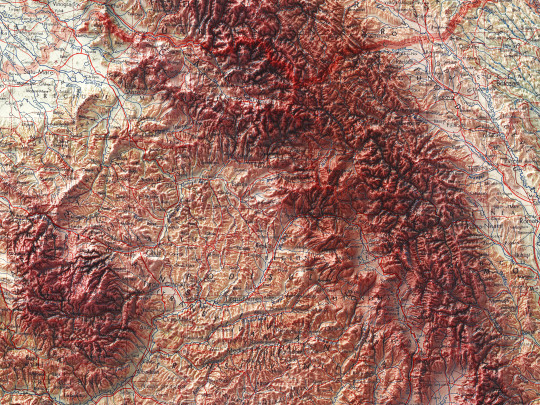
Shaded relief map with 3D effect of a topographic map of Fort Collins, Colorado (United States of America), in the quadrangle series and prepared and published by U.S. Geological Survey in 1906.
If you like our work, want to see our daily updates (or want to say hello to our studio), consider to follow our Instagram or Twitter account. Otherwise if are interested in our prints or have a custom request check our shop.
#homedecor#shadedrelief#shadedreliefmaps#map#cartography#cartographer#cartographie#cartographycommunity#vintagecartography#usa#usa🇺🇸#fortcollins#fortcollinsart#fortcollinscolorado#coloradogram#coloradotography#coloradosprings#3darts#digitalart#digitalartist#blendercycles#blenderartist#fineartprints#fineartprintshop#fineartprintstore#fineartprintstudio
7 notes
·
View notes
Photo
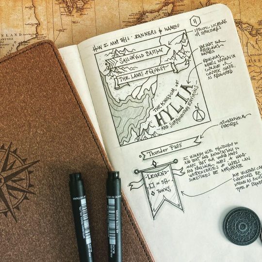
Been quiet for a bit because my dog, Scully, had been sick and we’ve been busy trying to get her back to 100%. Unfortunately, I haven’t been as productive as I’d like to be considering I have a ton of patron projects to finalize, but life takes priority, I think.anyway, enough ramblings from me - here are my belated Days 11-19 of the #howyoumap challenge! Still got some catching up to do but there’s more on the way! #maps #cartography #cartographyart #handdrawn #drawing #sketch #penandink #ttrpg #worldbuilding #worldbuildingart #mapmaking #fantasyart #fantasymapmaking #fantasymaps #fantasy #cartographycommunity https://www.instagram.com/p/CMxOGcphYE5/?igshid=1uqi8j0hjoc7a
#howyoumap#maps#cartography#cartographyart#handdrawn#drawing#sketch#penandink#ttrpg#worldbuilding#worldbuildingart#mapmaking#fantasyart#fantasymapmaking#fantasymaps#fantasy#cartographycommunity
4 notes
·
View notes
Text
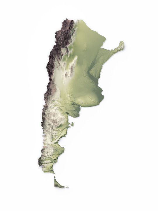
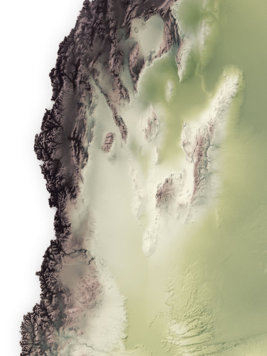
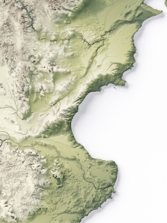

We made a series of elevation maps of Argentina.
The first shows the geological gradient starting with deep green and ending with the highest point on dark brown.
If you like our work, want to see our daily updates (or want to say hello to our studio), consider to follow our Instagram or Twitter account. Otherwise if are interested in our prints or have a custom request check our shop.
#argentina#argentinaig#argentinatravel#argentina🇦🇷#southamerica#southamericatrip#sudamérica#latinamerican#mappe#map#cartography#cartographyartist#cartographycommunity#cartographymagazine#cartographycollective#cartographyproject#GIS#elevationmap#america#geography#geografía#shadedreliefmaps#mapoftheworld
13 notes
·
View notes
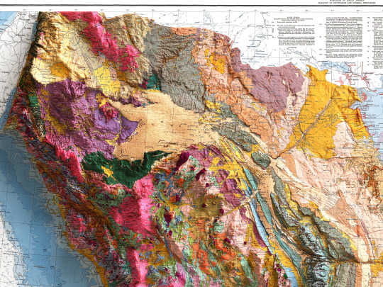
Text


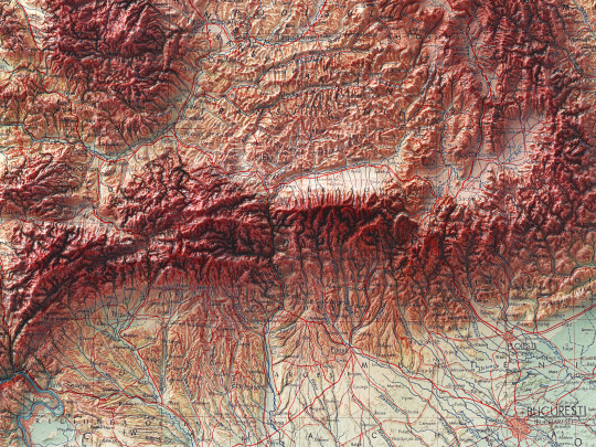
Another Pergamon map join to our family!
Lightly restored, with exaggered relief, this piece set off our return to topographic and geological maps.
So say hello to Romania!
🗺️ 𝗠𝗔𝗣 𝗜𝗡𝗙𝗢
Romania. (inset) Iron Gate. (inset) Bucharest. Pergamon World Atlas. Pergamon Press, Ltd. & P.W.N. Poland 1963. Sluzba Topograficzna W.P.
Source: David Ramsey collection
If you like our work, want to see our daily updates (or want to say hello to our studio), consider to follow our Instagram or Twitter account. Otherwise if are interested in our prints or have a custom request check our shop.
#cartography#mapstagram#googlemaps#map#topography#topographyart#topographymap#cartographycommunity#cartographytravel#gis#qgis#blender3d#blenderart#blendercycles#blendercommunity#romaniamagica#românia#romanianblogger#bucharestlife#bucharest#europemap#shadedreliefmap#3dmaps#Atlas
5 notes
·
View notes
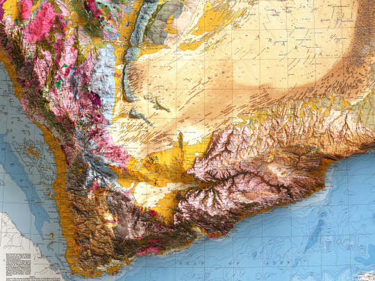
Text

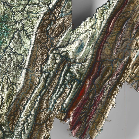

A new map from the past.
This was supposed to be part of a great new series on North America, but we are not currently free enough to plan a thematic collection, so we hope you will still enjoy the end result and digital restoration of this 1932 Geological map of West Virginia.
🗺️ 𝗠𝗔𝗣 𝗜𝗡𝗙𝗢
Geological map of West Virginia, West Virginia Geological and Economic Service, 1932.
If you like our work, want to see our daily updates (or want to say hello to our studio), consider to follow our Instagram or Twitter account. Otherwise if are interested in our prints or have a custom request check our shop.
#printdesign#3dmap#topographic#VintageMap#vintagemaps🗺#storicalmaps#usamap#usamaps#USGS#WestVirginia#westvirginiamountains#westvirginiauniversity#Virginia#UnitedStates#cartography#cartographyproject#cartographycommunity#geologia#geological#geologists
0 notes
Text

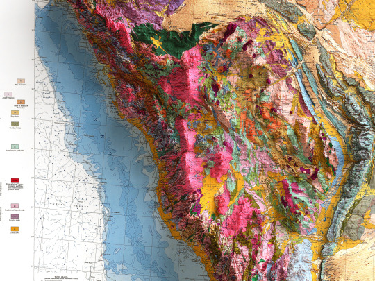
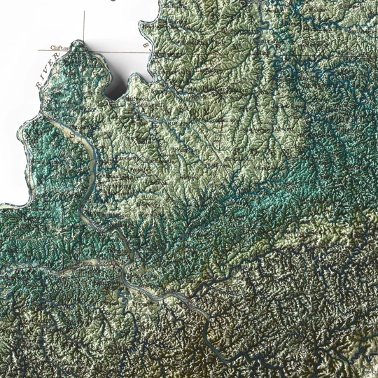
With this soil map, we go a long way from home as we explore the Arabian Peninsula.
The map was realised in 1963 through the joint sponsorship of the governments of the United States and Saudi Arabia.
🗺️ 𝗠𝗔𝗣 𝗜𝗡𝗙𝗢
Soil map of the Kingdom of Saudi Arabia. Ministry of petroleum and mineral resources. Compiled by the U.S. Geological Survey and the Arabian American Oil Company untder the joint sponsorship of the Kingdom of Saudi Arabia, Ministry of the Petroleum and Mineral Resources, and the U.S. Department of State; 1963.
If you like our work, want to see our daily updates (or want to say hello to our studio), consider to follow our Instagram or Twitter account. Otherwise if are interested in our prints or have a custom request check our shop.
#saudiarabia#saudiarabian#arabianpeninsula#geologyporn#mapporn#cartography#cartographyart#cartographycommunity#oilcompany#geologicalsurvey#shadedrelief#petroleum#petroleumgeology#3dmap#3dmapping#yémen#asiamaps
1 note
·
View note
Last Seen Blogs

accirax
nous arrivons a silly


adry-flowers
Miss Flowers

himawariart
sketches & stuff

clarasunflowers
🌻🌻🌻