#cape engano
Text
Porte-avions japonais Zuiho attaqué par des avions de l'USS Enterprise pendant la bataille du Cap Engano – Bataille du golfe de Leyte – Campagne des Philippines (1944-1945) – Guerre du Pacifique – Luçon – Philippines – 25 octobre 1944
#WWII#guerre du pacifique#pacific war#campagne des philippines (44-45)#philippines campaign (44-45)#bataille du golfe de leyte#battle of leyte gulf#bataille du cap engano#battle off cape engano#marine impériale japonaise#imperial japanese navy#ijn#porte-avions#aircraft carrier#classe zuiho#zuiho-class#zuiho#cap engano#cape engano#luçon#luzon#philippines#25/10/1944#10/1944#1944
16 notes
·
View notes
Photo

“A near miss on Japanese battleship Ise, during the battle off Cape Engano, 25 October 1944.”
(NHHC: 80-G-288106)
42 notes
·
View notes
Photo


You know that thing when you’re getting old (yup, hello titohood), you easily get tired of noisy parties and rowdy crowd, and you just want a place where you can share your epic stories with the people closest to you. So in our quest to avoid the crowd in hopes of discovering totally off the path and more serene destinations, our journey had taken us to this otherworldly paradise situated north of Sta. Ana Cagayan that was Palaui Island. This jewel is a protected landscape and seascape and has been a Natural Reserve since 1994. Home to some of the most abundant ocean waters and captivating views, Palaui Island is set to leave you in awe for the rest of your life.
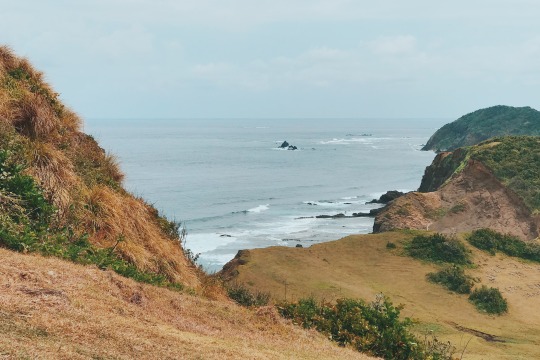
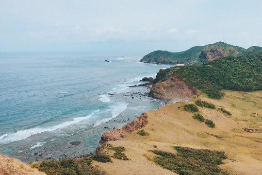
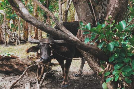
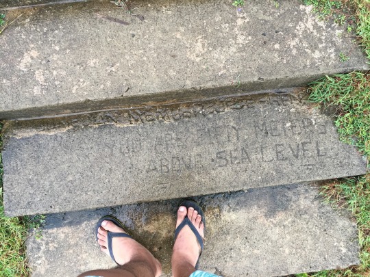
The view went from beautiful to breathtaking the higher we went. I was mostly alone during the hike up to the parola as I kept on pausing to look back and take a picture (read: I am a slow walker). Eventually, the two sides of Palaui Island came into view, the coral beach on the right and another smaller beach, blasted by enormous waves from the Pacific Ocean, on the left. And in between these, the rolling hills of Palaui Island. I gazed at the scene as a herd of carabaos was right on the cliff (i mean, how?!).
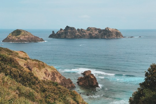
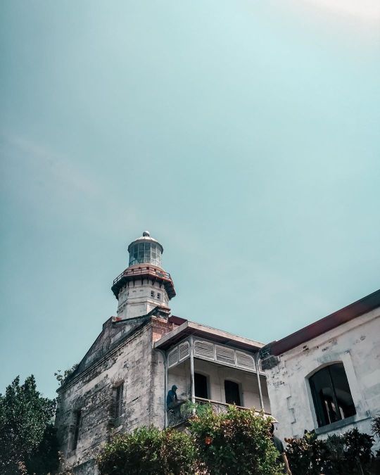
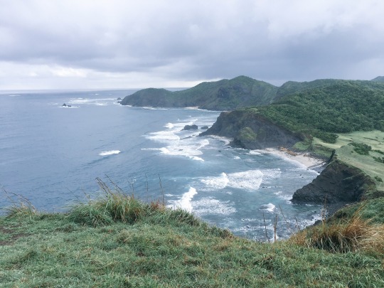
Sadly, the Cape Engaño Lighthouse is now in disrepair, with its two-foot walls doing the Angkor Wat routine—being eaten and reclaimed by wilderness in poetic slow motion. Besides the towering twin sentinels of an island dubbed as the Dos Hermanas, there’s nothing here but the full orchestra of the Earth; the gust of the wind, the massive sound of the crashing waves, and the full grandness of the ocean.
Lush, rough-hewn and deserted, Palaui exudes an ends-of-the-earth beauty.


The trail to Cape Engano involved some light hiking passing inside a forest filled with marked trees and to a wide grassland with rolling terrain reminiscent of the landscape in Batanes. The highlight of the trail is what remains of Cape Engano, a lighthouse built during the Spanish colonization period, completed in 1898. (Note: Those who don't want to hike can opt for a boat ride from Punta Verde).
To cap off the day, our last destination is the Anguib Beach which is 40 minutes away from Cape Engano. It is actually not located in Palaui Island anymore but on mainland Cagayan. Among all the beaches we’ve seen so far (Punta Verde, Cape Engano Beach, Mabolbol Shore) in this trip, Anguib beach is most ideal for swimming. It boasts a long stretch of fine white sand and clear waters. Staying overnight in Anguib beach is also possible, just bring your own tent.
Palaui is a rural area of a fishing community with most homes powered only by generators and solar panel. Electricity in the island is not available at night so if you are planning to stay over, make sure to bring a power bank or fully charge your gadgets ahead. Despite Palaui only a sight away from Santa Ana, it is still advised to visit during the summer days of late March to May when seas are calm. Getting to the island would mean heading out to the open sea where waves can be wild and rough.


After this adventure, on the way to our hotel peeking through the windows, the road was eerily quiet as if it was already past midnight in this part of the world when in reality, it was still 7 in the evening. I guess this is what I missed about the life in the province – there is no need to rush.
Everyone can take a rest without feeling guilty like time is being wasted.
#original photographers#photographers on tumblr#photography#travel#cagayan#palaui island#vsco#lensblr#vsco film#Philippines
42 notes
·
View notes
Text
The 10 Decisive Battles of World War II
U.S. Landing Ships delivering vehicles and supplies to American troops on Omaha Beach during the Allied invasion of Normandy. Many regard this as the decisive battle in the European Theater of World War II.
In the seventy years since the end of World War II, the legacy of the largest and deadliest conflict in human history remains prevalent to this very day. It was a global conflict fought with incredible ferocity, leaving entire nations devastated, millions dead, and many more wounded. To forget the lessons of this great and terrible war would be a disservice to the sacrifices made by so many. At least 50 million people died in World War II, but others suggest that the total number is higher than 80 million, including war-related factors such as disease and famine. The conflict pitted the Axis Powers, a fascist military alliance made up of Nazi Germany, Italy, the Empire of Japan, and several other nations, against the Allied Powers, an international coalition led by the United States of America, Great Britain, France, the Soviet Union, and China.
The war began on September 1, 1939, after Nazi Germany invaded Poland, compelling Great Britain and France to declare war against Germany. The conflict expanded into the Pacific on December 7, 1941, after the Empire of Japan launched a pre-emptive strike against the U.S. Pacific Fleet based at Pearl Harbor, Hawaii. This list covers a series of battles fought during the war which held the greatest strategic implications, where the difference between victory and defeat could have changed the course of history. These are the ten decisive battles that ultimately decided the outcome of World War II.
10) The First and Second Battle of El Alamein
Date: July 1- November 11, 1942
Location: El Alamein, Egypt

July 17, 1942: British troops man defensive positions just outside El Alamein, Egypt.
For two years, the North African Campaign had been a series of seesaw battles fought back and forth across the Libyan Desert between the Axis Powers of Nazi Germany and Italy, and Allied forces primarily from British Commonwealth nations. In June 1942, German and Italian troops of Panzer Army Africa were pushing deep into Egyptian territory. Led by the legendary German Field Marshal, Erwin Rommel, Axis forces were threatening to advance on Alexandria, Cairo, and the Suez Canal. With the fate of North Africa and the Middle East in the balance, the British Eighth Army made a stand at the coastal town of El Alamein. Confined along a narrow front between the Mediterranean Sea to the north and the impassable Qattara Depression to the south, Panzer Army Africa was unable to outflank the British defense line. The First Battle of El Alamein (July 1- 27) ended in a bloody stalemate with heavy losses on both sides, but the Allies had finally managed to stop the Axis advance.
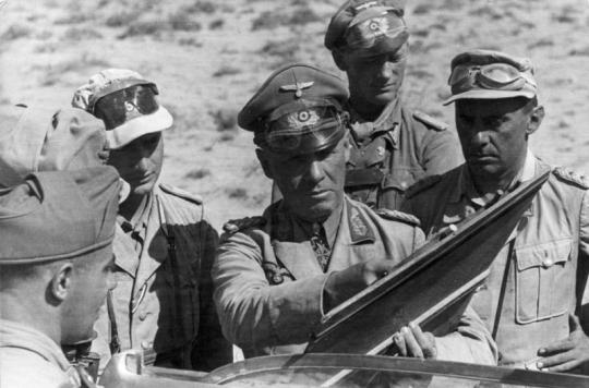
June 21, 1942: The commander of Panzer Army Africa, Field Marshall Erwin Rommel, speaks with German and Italian officers during the Western Desert Campaign.
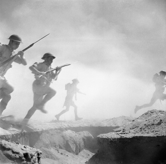
October 24, 1942: Australian troops of the 9th Infantry Division charge into combat during the Second Battle of El Alamein.
Rommel desperately needed reinforcements and supplies, but Germany and Italy had committed their efforts to defeating the Soviet Union on the Eastern Front, while the Allies poured troops and resources into Egypt for a major counter-offensive. In the Second Battle of El Alamein (October 23- November 11), the British Eighth Army, now led by the audacious General Bernard Montgomery, launched an all-out attack that finally broke through the Axis defense line after bitter fighting and heavy losses on both sides. Losing almost one third of their strength, Panzer Army Africa was forced to retreat all the way back through Libya with Montgomery’s Eighth Army in pursuit. Not only had the Allies secured Egypt, they denied the Axis Powers vital access to the oilfields of the Middle East. The critical victories at El Alamein combined with Allied amphibious landings in Morocco and Algeria doomed the Axis to defeat in the North African and Mediterranean Theater.
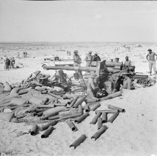
November 7, 1942: British troops inspect an abandoned German 88mm artillery gun along the Coastal Road near El Alamein, as Axis forces begin retreating to Libya.
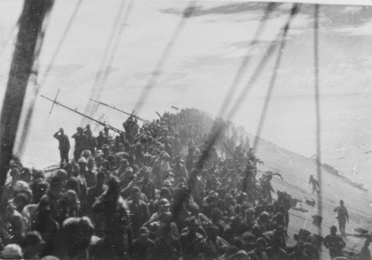
9) The Battle of Leyte Gulf
Date: October 23- 26, 1944
Location: Leyte Gulf, the Philippines

October 23-26, 1944: A map detailing the four major naval engagements that occurred during the Battle of Leyte Gulf in chronological order (1. Sibuyan Sea, 2. Surigao Strait, 3. Cape Engano, 4. Samar).
The largest naval battle of World War II was the decisive battle of the Pacific Theater. On October 20, 1944, American-led Allied forces began their long- awaited campaign to liberate the Philippines from Japanese occupation with amphibious landings at Leyte Gulf. If the Empire of Japan lost control over the Philippines, they would be cut off from their vital supply of oil from the Dutch East Indies (Indonesia). Despite two years of heavy losses in the Pacific, the Imperial Japanese Navy (IJN) launched a desperate all-out offensive to destroy the U.S. landing force at Leyte Gulf. The IJN Center Force, led by Admiral Takeo Kurita, lost two heavy cruisers to U.S. Navy submarines while sailing through the Palawan Passage in the Western Philippines. The Task Force then came under intense air attacks in the Sibuyan Sea, forcing Kurita to withdraw his ships. The IJN Southern Force was utterly decimated by battleships of the U.S. 7th Fleet further south in the Surigao Strait. The IJN Northern Force centered around three light carriers and Japan’s last major aircraft carrier, Zuikaku, took a severe beating by the Americans at Cape Engano but succeeded in luring the powerful U.S. 3rd Fleet under Admiral William Halsey away from Leyte Gulf.

October 24, 1944: The Japanese super battleship, Yamato, under attack by U.S. Naval aircraft in the Sibuyan Sea. This photograph was taken just after a bomb had struck the ship’s forward gun turret.

October 24, 1944: An American light aircraft carrier, USS Princeton (CVL-23), burns and explodes just east of Luzon after suffering catastrophic damage during the Battle of Leyte Gulf.
Meanwhile, the IJN Center Force, which the Americans believed was retreating, actually turned around and broke through the unguarded San Bernardino Strait, just north of Leyte Gulf, and headed south. With the 3rd Fleet out of position, the U.S. landing force was left exposed and vulnerable. A valiant stand made by a small task force of U.S. screening vessels just east of Samar successfully repulsed the Japanese outside Leyte Gulf and secured victory for the Allies. The result of the battle was the near total destruction of the once powerful Imperial Japanese Navy. Over 12,500 Japanese were killed, and two dozen ships were sunk, including the aircraft carrier Zuikaku, and the super battleship Musashi. The Liberation of the Philippines was all but guaranteed by that point. The United States had severed the link between the Empire of Japan and the oil fields of the Dutch East Indies, and the Allies had secured total naval superiority in the Pacific. For the Japanese, Leyte Gulf had all but assured their defeat in World War II.
October 25, 1944: With their ship listing heavily and on the verge of sinking, the crew of the aircraft carrier, Zuikaku, salute as the Imperial Japanese flag is lowered.
8) The Battle of Moscow
Date: October 2, 1941- January 7, 1942
Location: Moscow, Russia, Union of Soviet Socialist Republics
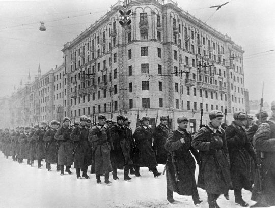
December 1, 1941: Soviet troops of the Red Army march through Moscow on their way to fight the Germans on the frontlines just outside the city.
Four months after invading the Soviet Union in Operation Barbarossa, the German Wehrmacht was within striking distance of Moscow. But an offensive on the Soviet capital was delayed due to stubborn resistance by the Red Army at Smolensk and Hitler’s insistence on capturing Leningrad and Kiev first. German commanders argued for an immediate attack on Moscow while the Red Army was still weak and in disarray, but Hitler believed that the fall of Leningrad and the Ukraine would do far more damage economically and militarily to the Soviet Union. This delay gave the Red Army invaluable time to reorganize and reinforce their defenses for the coming battle.
The Soviet Union raised reserve armies, elite units were brought in from Siberia, and several formidable defensive lines were established around Moscow. Only when the Ukraine had been captured and Leningrad encircled did the Wehrmacht resume their advance on the Soviet capital. After two months of intense fighting, the German offensive was bogged down just outside the city due to fierce Soviet defenses, heavy losses, chronic supply shortages, severe winter weather, and Soviet guerrilla fighters operating in the occupied territories. German troops actually came within 15 miles of the Kremlin, but they were woefully unprepared to wage a winter campaign, and thousands froze to death.

November 30, 1941: Two German soldiers on guard duty just west of Moscow endure the harsh conditions of the Russian Winter.
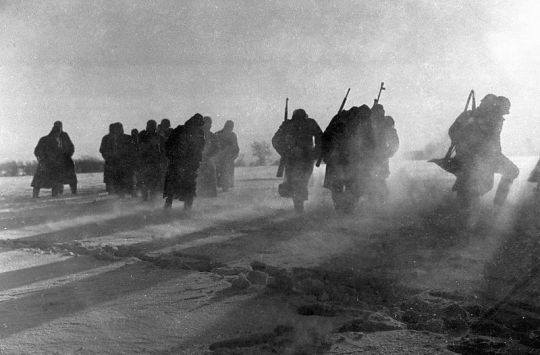
December 27, 1941: A group of German soldiers march across an icy snow-covered field during the Battle of Moscow.
Reinforced by reserve units and Siberian troops, the Red Army launched a massive counteroffensive with over 1,100,000 men. Unlike the Germans, the Russians were perfectly trained and equipped to fight in winter conditions. Despite determined resistance, the exhausted German Army was gradually driven back and defeated.
The Battle of Moscow was a major symbolic and psychological victory that galvanized the Soviet Union. While the losses of 1941 were horrific, the Red Army would rebuild and grow stronger as the war went on. Hitler originally believed that the Soviet Union would be defeated by the end of 1941, but this assessment proved to be wildly optimistic. Nazi Germany was confronted with the prospect of fighting a long war of attrition on the Eastern Front. The Axis Powers were unprepared for a prolonged campaign of this scale, which they were bound to lose the longer it went on.
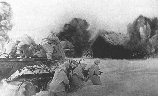
December 31, 1941: A Soviet T-34 Tank with supporting Infantry attack a German-controlled village just outside Moscow.
7) The Battle of Kursk
Date: July 5- August 23, 1943
Location: Kursk, Russia, Union of Soviet Socialist Republics
July, 1943: German Tiger I tanks prepare to attack Soviet defenses in the northern sector of the salient around Kursk, Russia.
Seeking to regain the initiative on the Eastern Front after the catastrophic defeat at Stalingrad, Nazi Germany assembled a massive force to encircle and destroy Red Army formations around the city of Kursk. Soviet and British intelligence agencies had attained information of the coming offensive months in advance, giving the Red Army plenty of time to prepare defenses. German forces along the Eastern Front were already badly under strength; gathering troops and resources for an attack on Kursk would take time. The Germans significantly delayed the start of the offensive as they waited for the delivery of additional armored vehicles, including the new advanced Panther tanks and the fearsome Tiger Tanks. Meanwhile the Red Army continued to fortify its positions. By the time the Germans attacked, the Soviets had established a series of formidable defensive lines around Kursk, turning the area into a giant fortress. The ensuing battle would go down in history as the largest clash of tanks in the annals of warfare, including a particularly savage tank battle at the town of Prokhorovka just southeast of Kursk.

July, 1943: German troops from the 2nd SS Panzer Division with a Tiger I Tank on the offensive against the Red Army during the Battle of Kursk.
July, 1943: Soviet troops armed with PTRD-41 anti-tank rifles come under heavy fire as they defend the southern sector of the Kursk salient.
The Soviets suffered incredibly heavy losses, but German losses in tanks, equipment, and personnel were irreplaceable. The exhausted Wehrmacht had barely made it halfway through Soviet defenses when, at the height of the battle, Hitler called off the offensive. He then proceeded to transfer troops from Russia to Italy in preparation for an Invasion by the Western Allies. By July 16, the Wehrmacht had withdrawn to its original frontline around the Kursk salient. Once the Germans had been significantly weakened, the Red Army unleashed its massive reserves in a crushing counteroffensive to the north and south of Kursk, capturing key cities, and inflicting even heavier losses on the Wehrmacht. From that point on, the Soviet Union would remain on the offensive until the end of the war. The Red Army had evolved dramatically from the disasters of 1941, transforming itself into an efficient military force to be reckoned with. The Battle of Kursk had completely shattered the Wehrmacht’s offensive capabilities on the Eastern Front. Nazi Germany was doomed to fight a defensive war it could not hope to win against a massive army that was growing in strength and numbers.

September, 1943: Following their victory in the Battle of Kursk, the Red Army launches a major counteroffensive against the Germans near Bryansk, Russia.
6) The Battle of Britain
Date: July 10- October 31, 1940
Location: British Airspace

September 7, 1940: A Heinkel He 111 bomber flown by the German Luftwaffe takes part in a bombing raid over the docks in the East End of London, England.
After the fall of France in June 1940, Nazi Germany had established its dominance over Western Europe. Only Great Britain remained unscathed. When the British refused to accept Germany’s terms for peace, Adolf Hitler ordered the Luftwaffe (Air Force) to establish air superiority over Britain in preparation for a large-scale airborne and amphibious invasion codenamed Operation Sea Lion. Wave after wave of German fighters and bombers flew across Southern England attacking key military and industrial sites while seeking to destroy British fighter aircraft in air-to-air combat. From the start of the campaign, the Luftwaffe faced stubborn resistance from the fighter pilots of the Royal Air Force (RAF). Advancements in the development of radar gave the British a critical advantage, allowing them to detect and track German aircraft taking off from airfields in Nazi-occupied Europe. This, along with information from ground observers, allowed the British to scramble fighters and accurately intercept Luftwaffe formations over England. The Battle of Britain became a grueling war of attrition with heavy losses on both sides. As the air battles intensified in scale and frequency, RAF Fighter Command was increasingly pushed to its breaking point. British airfields were continuously being bombed, the RAF was struggling to field adequately trained new pilots to replace those lost in battle, and those who were still flying were on the brink of exhaustion.

September 7, 1940: Smoke rises from fires raging at the Surrey Docks in London following a Luftwaffe bombing raid.

September 7, 1940: A group of Czech fighter pilots and their British flight commanders with Squadron 310 enjoy a much-needed break at their airfield in Duxford, England. Foreign volunteers from around the world would help play a vital role with the RAF in the Battle of Britain.
On the night of August 25, RAF bombers launched a surprise attack against Berlin in retaliation after German aircraft had accidentally bombed London the previous night. In response, an enraged Hitler ordered the Luftwaffe to bomb British cities into ruins. By targeting the civilian population instead of military airfields, the Germans gave the RAF invaluable time to rebuild their fighter squadrons and repair their infrastructure. Believing that the RAF had been neutralized, the Germans were shocked when the British took to the skies with renewed strength, inflicting heavy losses on Luftwaffe formations. Unable to achieve air superiority over Southern England after three months of bitter fighting, Hitler cancelled Operation Sea Lion so he could focus on the coming war with the Soviet Union. For the British, this was a huge symbolic and psychological victory. It was the first major defeat suffered by Nazi Germany, and it would come to have major strategic ramifications. Great Britain would become the staging point for Allied campaigns to liberate Africa and Europe from Axis control. The failure to knock Britain out of the war would ultimately come back to haunt Hitler.

September 25, 1940: A gun camera records the action as a Supermarine Spitfire flown by a British pilot in the Royal Air Force (RAF) 609 Squadron, engages a formation of Heinkel He 111 bombers near Bristol, England.
5) Operation Barbarossa
Date: June 22- December 5, 1941
Location: Union of Soviet Socialist Republics (Ukraine, Belarus, the Baltic States, Russia, and Eastern Poland).

June 22, 1941: Troops of the German Wehrmacht invade the Soviet Union in what would become the largest and bloodiest campaign in the annals of warfare.
Operation Barbarossa was the largest military campaign in the history of warfare. Led by Nazi Germany, the Axis Powers amassed over four million troops for the invasion of the Soviet Union. Taken completely off guard by the speed and ferocity of the German Blitzkrieg, Soviet units along the western frontier were utterly decimated. The German Wehrmacht demonstrated clear superiority in leadership, training, tactics, weaponry, and combat experience over the Red Army. The Soviet Union suffered over four million casualties, entire formations were destroyed, and large swaths of territory fell under Nazi occupation. But as time went on, the invasion gradually lost momentum. The Germans were slowed by stubborn Soviet defenses in key battles at Brest Fortress, Minsk, Smolensk, Uman, Odessa, Kiev, Sevastopol, and Rostov. The deeper the Axis forces pushed into the Soviet Union, the further they stretched their supply lines to the breaking point. Months of savage fighting and the ongoing logistical crisis took its toll on the invaders.

July 16, 1941: German Cavalrymen enter a town near Mogilev, Byelorussia (Belarus) after intense fighting with the Red Army.

September 1, 1941: Soviet troops man defensive positions around Leningrad. Unable to capture the city during Operation Barbarossa, Axis forces would lay siege to Leningrad for over two years until the Red Army finally relieved the city on January 24, 1944.
While the Red Army had suffered appalling losses, the Soviet Union was able to mobilize its vast resources in manpower and industry to replace what they had lost. The Soviets were also aided tremendously by massive logistical and economic aid provided to them by the United States through the Lend-Lease Act. Soviet troops fought with increased skill and tenacity after learning harsh lessons from the early stages of the war. Far from breaking the Soviet Union, the Wehrmacht was confronted with increasingly fierce resistance. The Germans lacked the strength to seize Leningrad by force, so they laid siege to the city for over two years in a failed attempt to starve the defenders into submission. Elsewhere, German troops were slowed by the autumn rains which turned the roads to mud, and the onset of winter grounded them to a halt just outside Moscow. Despite achieving spectacular victories during the initial period of the invasion, Operation Barbarossa ended in failure for the Axis Powers. Both sides faced the prospect of a long war of attrition, which Nazi Germany had little hope of winning. With superior manpower and resources, the Soviet Union would grow stronger as the war progressed. Hitler’s dream of expanding the German Reich by conquering the Russian homeland would ultimately set the stage for his demise.

October, 1941: Mechanized German units battle Soviet troops in the streets of Kharkov, Ukraine.
4) The Battle of the Atlantic
Date: September 3, 1939- May 8, 1945
Location: Atlantic Ocean

October, 1941: Escorting a large supply convoy across the Atlantic Ocean, officers on the bridge of a British destroyer scan the waters for signs of German U-Boats.
The Battle of the Atlantic was the longest and most bitter campaign fought during World War II. It lasted from September 1939, when the war in Europe broke out, to May 1945 when Nazi Germany surrendered. It was also the largest battlefield in history, covering the entire Atlantic Ocean, from the shores of Europe and Africa, to the coasts of North and South America. As an island nation, Great Britain was entirely dependent on a constant flow of supplies shipped in from across the Atlantic. The German Kriegsmarine (War Navy) sought to cut Britain’s lifeline by enforcing a naval blockade. Germany's surface fleet proved to be no match for the powerful Royal Navy, but their most effective ships against the British hid silently beneath surface, striking with little to no warning. German U-Boats swarmed the Atlantic, hunting and sinking Allied merchant ships at will. The period from 1940 to 1941 was the most difficult for the Allies as hundreds of ships and their precious cargo were sunk.

November 27, 1941: An American SB2U Vindicator Scout-Bomber from the aircraft carrier, USS Ranger (CV-4), flies an anti-submarine patrol for an Allied supply convoy headed for Cape Town, South Africa.

March, 1942: Allied tanker, Dixie Arrow, begins to break in half and sink to the bottom of the Atlantic after being torpedoed by German submarine U-71.
Despite traveling with armed surface escorts, Allied merchant convoys were facing coordinated hit-and-run attacks by U-Boats operating in groups called “wolf packs.” At times, the Germans actually came close to severing the shipping routes to Great Britain. But by 1942, the tide of the war was turning against Germany. A combination of new tactics, technology, and intelligence helped the Allies defeat the U-Boats, such as the development of sonar, improved anti-submarine countermeasures, increased air cover by Allied aircraft, the massive production of merchant ships and escorts by the United States, and the breaking of the enigma code used by U-Boats to communicate via radio. The tables had turned in the Atlantic, as the hunters became the hunted. By 1943, the U-Boat threat had been effectively neutralized. From 1939 to 1945, 3,500 Allied merchant vessels were sunk, along with 175 warships, and 72,000 Allied seamen had lost their lives in the Atlantic. The Germans lost 783 U-Boats, and out of the 40,000 men who served in the U-Boat fleet, 30,000 were killed. Germany’s campaign to starve the British into submission, had ended in failure. With the naval blockade broken, the Allies were able to build up their forces in Great Britain for the coming invasion of Nazi-occupied Europe.

November 5, 1943: German submarine U-848 comes under attack by U.S. Naval aircraft in the South Atlantic.
3) The Battle of Midway
Date: June 4- 7, 1942
Location: Midway Atoll, 1,300 miles west of Hawaii

June 6, 1942: A Squadron of American SBD Dauntless dive bombers from the aircraft carrier, USS Hornet (CV-8), fly over a burning Japanese heavy cruiser near Midway.
This was the battle that many regard as the turning point of the Pacific Theater. By May 1942, the Empire of Japan had conquered most of the western Pacific, while the U.S. Pacific Fleet was still weakened from losses suffered during the surprise Japanese attack on Pearl Harbor five months earlier. During the Battle of the Coral Sea (May 4- 8), the Pacific Fleet managed to repel a Japanese offensive in New Guinea and cripple two IJN aircraft carriers, but the Americans lost the aircraft carrier USS Lexington. The U.S. Navy was left with only three aircraft carriers to counter Japan’s next move in the Pacific. Meanwhile the Imperial Japanese Navy was planning a major offensive which they hoped would destroy the U.S. Pacific Fleet once and for all. By seizing a strategic airfield just west of Hawaii on the island of Midway, Japanese commanders hoped to force the U.S. Navy to commit its valuable aircraft carriers to repel the invasion. Once lured out of Pearl Harbor, the American carriers would be destroyed by superior Japanese forces in a battle to retake the island. But unbeknownst to the Japanese, U.S. naval intelligence had deciphered their radio transmissions and uncovered their plan to invade Midway.

June 4, 1942: The American aircraft carrier, USS Yorktown (CV-5), suffers a direct hit from a torpedo dropped by a Japanese B5N torpedo bomber during the Battle of Midway.

June 6, 1942: The Japanese Heavy Cruiser, Mikuma, suffers catastrophic damage from U.S. Naval air attacks during the Battle of Midway. This picture was taken by an SBD Dauntless shortly before the Mikuma sunk into the Pacific Ocean.
When the Combined Japanese Fleet sailed in to attack, all three American aircraft carriers were already waiting near Midway, ready to spring the trap. Taken completely by surprise, four Japanese aircraft carriers were sunk for the destruction of one American carrier, the USS Yorktown. For the United States, this was a victory of epic proportions. The Japanese carriers sunk near Midway: Akagi, Hiryu, Kaga, and Soryu, were four of the six carriers that had carried out the attack on Pearl Harbor. Imperial Japan’s aura of invincibility was shattered and their ability to carry out offensive operations had been severely degraded. It was a devastating defeat from which the Japanese would ultimately never recover from. The scale of their victory at Midway gave the United States invaluable time to gather their strength as they prepared to go on the offensive in the Pacific. The Americans were able to raise and repair many of the ships lost at Pearl Harbor and their massive industrial economy produced new warships at a rate that the Japanese could never match. For the Empire of Japan, the Battle of Midway was the beginning of their downfall.

June 20, 1942: USS Ballard picks up survivors from the Japanese aircraft carrier, Hiryu, two weeks after it was sunk by U.S. Naval aircraft during the Battle of Midway.
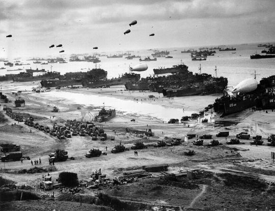
2) The Invasion of Normandy
Date: June 6- August 30, 1944
Location: Normandy, France

June 6, 1944: U.S. troops from the 1st Infantry Division disembark from a Coast Guard Landing Craft and advance towards a section of the Normandy coastline designated Omaha Beach during the Allied Invasion of Nazi-occupied France.
This was the battle that decided the fate of Western Europe. After years of planning, preparations, and training, Allied forces based in Great Britain were finally ready to launch the long-awaited Invasion of Nazi-occupied Europe. Across the English Channel, the Germans constructed a series of formidable defensive fortifications along the European coastline, dubbed the “Atlantic Wall.” Stretching from the Bay of Biscay in western France all the way to the arctic coast of Norway, the Nazi regime began building the wall in 1942 to repel any Allied Invasion of Western Europe. The Allies finally chose to carry out landings on the Normandy Peninsula, a region of Northern France which was reported to be the weakest section of the Atlantic Wall. In the meantime, Allied Intelligence carried out an elaborate deception campaign that kept the Germans confused as to where and when the invasion would take place.
In the early morning hours of D-Day, June 6, 1944, nearly 160,000 troops from several nations crossed the English Channel by sea and air destined for Normandy, France. Just after midnight, Allied airborne units were dropped inland behind German coastal defenses. Even though the paratroopers were badly scattered across Normandy, they still managed to capture key targets and were highly successful in creating chaos and confusion among German forces. The French Resistance assisted the Allies by harassing enemy troops and carrying out acts of sabotage on the German transportation and communication network in the region.

June 6, 1944: Landing craft carrying Canadian troops of the Royal Winnipeg Rifles towards Juno Beach during the D-Day Invasion of Normandy.
June 6, 1944: Royal Marine Commandos attached to the 3rd Infantry Division of the British Army advance into Normandy after landing on Sword Beach.
At dawn, the amphibious landings were successfully carried out along the Normandy coast with Allied troops capturing Gold, Sword, Juno, and Utah Beaches. U.S. troops faced the strongest defenses on Omaha Beach, where they suffered heavy casualties but still managed to overcome fierce German resistance to secure a small beachhead. Assisted by overwhelming air and naval firepower, the Allies were able to establish a foothold in Normandy. Allied troops gradually pushed further inland capturing key cities, such as Carentan, Cherbourg, and Caen. On July 25, the Allies launched Operation Cobra, a major offensive from Normandy, which lead to a rapid advance across France. The once powerful German Wehrmacht collapsed in the face of the onslaught. On August 25, Allied troops marched triumphantly into Paris, liberating the French Capital after four years of occupation. For the Western Allies, it was the defining Battle of World War II. For Nazi Germany, it was the beginning of the end as they were slowly crushed by the combined forces of the United States, Great Britain, France, and the Soviet Union.

July, 1944: U.S. troops of the 4th Armored Division advance through the town of Coutances during Operation Cobra, a major Allied offensive that would lead to the breakout from Normandy and the collapse of German armies across France.
1) The Battle of Stalingrad
Date: August 23, 1942- February2,1943
Location: Stalingrad (Volgograd), Russia, Union of Soviet Socialist Republics.

February, 1943: Soviet troops fighting across the ruins of Stalingrad, Russia. For over five months, the Red Army and the Wehrmacht fought bitterly for control of the city, resulting in the bloodiest and most destructive battle of World War II.
Many have regarded Stalingrad as the turning point of World War II. Not only was it the bloodiest urban battle ever fought, it was the single deadliest battle in history. After failing to outright destroy the Soviet Union during the initial invasion in 1941, Adolf Hitler sought to cripple the Soviet economy by seizing the oilfields of the Russian Caucasus. As Axis forces advanced into southern Russia, the German 6th Army was sent to capture the city of Stalingrad. Named after Soviet dictator Joseph Stalin, the city was symbolically meaningful for both sides. It was also a key industrial and transportation center for the region. Before the battle, the Luftwaffe mercilessly bombed Stalingrad, turning it into a heap of burning rubble. When the Wehrmacht finally launched its ground assault, they were met with fanatical resistance. German and Soviet troops fought block by block, street by street, and house to house for control of the city. Soviet reinforcements were rushed across the river Volga under heavy fire, and despite appalling casualties they managed to help prevent the city from falling completely into enemy hands. Parts of Stalingrad such as Mamayev Kurgan, the Central Railway Station, the Red October Factory, Pavlov’s House, the Grain Elevator, and even the sewers attained a level of infamy for the scale of death and suffering both sides endured during the battle.

October, 1942: A German soldier armed with a Russian PPSh-41 submachine gun looks out over the rubble of the Barrikady Factory in Stalingrad.

October, 1942: Soviet soldiers armed with German and Russian submachine guns defend the Red October Factory in Stalingrad from German attacks.
The Germans committed scores of troops and resources to the takeover of Stalingrad but left their flanks guarded by weaker Romanian, Hungarian, and Italian units. With the Russian winter on its side, the Red Army launched a massive counteroffensive with over one million troops against the weakened flanks to the north and south of Stalingrad. The Soviets broke through as the Romanians, Hungarians, and Italians collapsed in disarray. German troops in and around Stalingrad were horrified to find that they had been completely encircled by the massive Red Army. An offensive to break through to the city along with attempts by the Luftwaffe to resupply Stalingrad by air ended in complete failure. Freezing in subzero temperatures, ravaged by frostbite, starvation, and disease, German troops inside the shattered city fought valiantly but were eventually overwhelmed by the Red Army. Never before had Nazi Germany suffered a defeat so catastrophic.
The Battle of Stalingrad led to the destruction of the German 6th Army, elements of the 4th Panzer Army, along with the Romanian, Hungarian, and Italian Armies on the Eastern Front. In total, the Axis Powers suffered 850,000 casualties. It was a devastating loss from which they would never recover from. It is estimated that the Soviet Union suffered over 1,129,000 total casualties during the battle, but they had still prevailed. Galvanized by their historic victory, Soviet forces relentlessly pushed westward, driving the Germans all the way back to Berlin, culminating in the collapse of Hitler’s Third Reich in May 1945.
February 2, 1943: Soviet soldiers move through the center of Stalingrad following it’s liberation from German occupation.
(c) Daniel Ramos. January, 2016. No part of this article shall be reproduced in any manner without attribution to the author.
#world war II#battle of el alamein#north african campaign#battle of leyte gulf#philippines campaign#pacific theater#battle of moscow#eastern front#battle of kursk#battle of britain#western front#operation barbarossa#siege of leningrad#battle of the atlantic#u-boats#battle of midway#invasion of normandy#normandy landings#operation overlord#d-day landings#battle of stalingrad
11 notes
·
View notes
Photo
Cape Bojeador Lighthouse — a cultural heritage structure in the rustic town of burgos, also known as Burgos Lighthouse, established during the Spanish Colonial Period in the Philippines. It stands on top of Vigia de Nagparitan Hill, overlooking Cape Bojeador. The cape used to be very busy as galleons used to pass by. It’s been more than 100 years since it was established and it is still fully functional — a beacon signaling to ships that they have entered the Philippine territory. Marking the northwesternmost point of mainland Luzon, Cape Bojeador Lighthouse is the counterpart of Cape Engano Lighthouse in Palaui, Santa Ana, Cagayan, which marks the northeasternmost tip. I’m not really a fan of lighthouses but there was something in this place that was just attractive. It was very peaceful up there and it was very cinematic. It’s the kind of location that would be a perfect setting for a romantic film. Even from the staircase, we could already see the restless South China Sea. We entered the courtyard and started camwhoring away. There are few service buildings in the courtyard and lots of staircases. It was very, very windy. And looking up, you could see the tower as if it was moving and falling down on you. — swipe swipe swipe🥰 (at Cape Bojeador Lighthouse, Burgos Ilocos Norte) https://www.instagram.com/p/CAwdjENgqqW/?igshid=12kvetu4q13pq
0 notes
Photo

Battle off Cape Engano, 25 October 1944. Transferring Vice... http://ift.tt/2EF9GtR
1 note
·
View note
Photo

*+* Taito figure Shimakaze decisive battle mode Shimakaze Engano Cape decisive b... https://ift.tt/3eGObdL
0 notes
Link
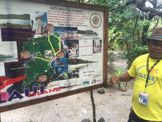
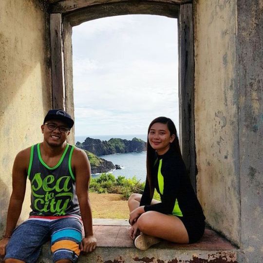
#CagayanValleyTour series. Got the chance to post this on IG over the weekend. On our second day, activities lined up were island hopping & swimming. It was a little over 45 minutes of boat ride to Palaui Island. (There was a Survivor season that featured Palaui.)
First stop was Cape Engano Cove & Lighthouse. More trekking & upward climb. 234 steps if I remember correctly. Sounds easy? It depends on how fit your are & how ready you are for physical activities such as trekking. Of course, it didn’t help that the sun was out so brightly, as Cagayan weather was a bit too hot and humid. A major challenge indeed. Lots of stops & photo opps along the way. Most of our photos have been shared on FB. I post a recap more or less on IG. Then, I blog here for the details.
More adventures next time... ta-tah! ^_^
#CagayanValleyTour#StaAnaCagayan#capeEngano#EnganoCove#EnganoLighthouse#travelgoals#bucketlist#wanderlust#itsmorefuninthephilippines
0 notes
Photo


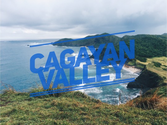
Cagayan
Cagayan Province is a bio-diverse province in the Cagayan Valley Region (CAR) in the Philippines. Its capital is the City of Tuguegarao. It’s bordered by mountains, has plains and valleys and different bodies of water. The largest river, Cagayan River which flows’ begins in Quirino also passes by Cagayan Province.
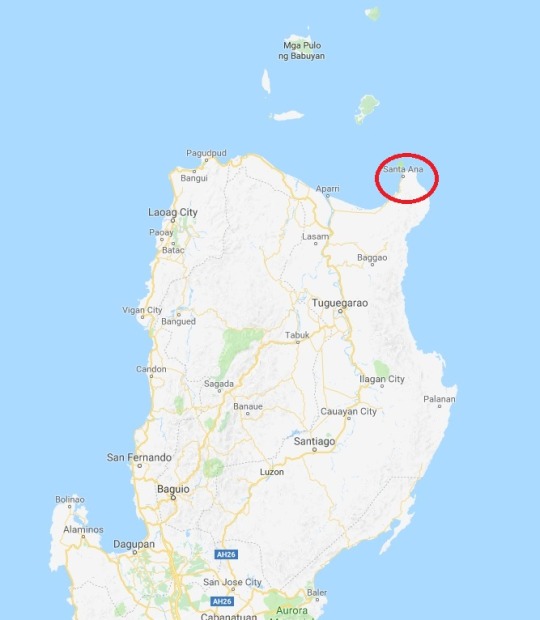
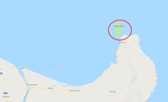
PALAUI ISLAND IN STA. ANA, CAGAYAN: The Hidden Paradise Up North
White Sand Beach in Palaui Island
Palaui Island was listed by CNN as one of the top 10 beaches in the world. It’s a certified eco-tourism area and where several water sports can be enjoyed by visitors and people who like fishing. The marine life of Palaui is very colorful and the island houses one of the two lighthouses built during the Spanish colonization, Cape Engano. This lighthouse is still functioning properly.
How to Get to Palaui Island?
Make your way to Tuguegarao, the capital city of Cagayan Province.
From there, ride a bus (~P240.00 as of December 2016) or van (P250.00 as of February 2017) going to Santa Ana, travel time is around three hours.
In Santa Ana, proceed to PASAMOBA office in San Vicente port for registration and to charter a boat to the island.
San Vicente port is a short trike ride from Sta. Ana town proper (P15.00 per passenger).
Activities:
Trek to the Picturesque Cape Engaño Lighthouse in Palaui Island
Beach Bumming at the Pristine White Sand Beach of Anguib
Meet the Locals or Trek to the Lighthouse via Punta Verde in Palaui Island
Explore Crocodile Island
Other activities:
Check Siwangag Cove, Find the hidden waterfalls, snorkeling and scuba diving, fishing, bird watching, sunrise and sunset viewing, hiking, camping, visit Jerolinda beach and Buacag Fall (mainland Sta. Ana), see Gotan mangrove and visit manidad falls, among many other activities in Palaui Island.
What is it known for?
Sta. Ana is the Philippine Sailfish Capital famous worldwide for its abundant marine life and is site of national and international game fishing competitions. The Cape Engaño Lighthouse in Palaui Island dates back to the Spanish Regime and is the only operational lighthouse in the northeastern coast.
Delicacies:
The best place to eat while island-hopping would be Jerolynda’s White Beach Resort and Restaurant in Mapurao, Brgy. San Vicente, Santa Ana. The delicious seafood lunch of local specialties including lobsters, prawns, lato, lumot (a type of seaweed), fish, sinigang and adobo.
DESIREE P. DULDULAO
0 notes
Photo

Cape Engano crew. 😎 #lakwatSEEras and #friends #summer2019 #roadtrip #islandhop #staana #cagayanvalley #itsmorefuninthephilippines🇵🇭 #yayontan #seeyayontan #yayontravels #comewithme https://www.instagram.com/p/BwvqZkllKYpSPAuCJ2SnhZNkBJhoorYyTvQ1nk0/?utm_source=ig_tumblr_share&igshid=1rustm25ybiwr
#lakwatseeras#friends#summer2019#roadtrip#islandhop#staana#cagayanvalley#itsmorefuninthephilippines🇵🇭#yayontan#seeyayontan#yayontravels#comewithme
0 notes
Photo

“Japanese aircraft carriers Zuikaku (center) and (probably) Zuiho (right) under dive bombing attack during the Battle off Cape Engano.
Bombs have hit the water near Zuikaku's port side. Patterns of explosions ahead of her and aft of the other carrier are from bursting anti-aircraft shells. Photographed from a USS Enterprise (CV-6) aircraft, whose wing is visible in the lower foreground. Data at bottom of print indicates the view was taken during the day's first attack. This view appears to have been taken shortly after that seen in Photo # 80-G-281767. Copied from an original print in the USS Enterprise action report for this battle, 1985.”
(NHHC: NH 95543)
#Military#History#Zuikaku#Aircraft carrier#Zuiho#Light carrier#Imperial Japanese Navy#IJN#WWII#WW2#Pacific War#World War II
41 notes
·
View notes
Text
Terceira tarefa
FLORES, Daniel. Transformação digital por inovação sustentada ou tecnologias disruptivas em arquivos. In: CAMPOS, Maria Luiza de Almeida et al. (Org.). Produção, tratamento, disseminação e uso recursos informacionais heterogêneos [recurso eletrônico]: diálogos interdisciplinares. Niterói, RJ: IACS/UFF, 2018. (Estudos da Informação, 5). p. 71-79.
O presente artigo foi apresentado na quinta edição do evento “Seminários de Estudos da Informação”, do Programa de Pós-graduação em Ciência da Informação (PPGCI) da Universidade Federal Fluminense (UFF). Uma iniciativa que possibilita um diálogo interdisciplinar a respeito da produção, tratamento, disseminação e uso de recursos informacionais heterogêneos, advindos de instituições de memória e cultura, como arquivos, museus e bibliotecas. A apresentação do artigo fez parte do eixo “Aquisição, seleção, avaliação e preservação de acervos”.
O artigo está dividido em uma introdução com desenvolvimento e considerações finais. Este foca nas transformações tecnológicas as quais a sociedade perpassa e a necessidade de uma análise dessas transformações a fim de assegurar que essas inovações possam ser utilizadas da maneira mais adequada. É abordado o conceito de transformação digital o qual pode ser desmembrado em duas alternativas: a inovação sustentada e a disrupção tecnológica.
A inovação sustentada é uma alternativa a qual é a mais almejada pela área, pela ciência; ela está relacionada aos referencias da Ciência, da Academia, da cientificidade. Como observador por Christensen (2013 apud FLORES, 2018), as inovações sustentadas ajudam organizações líderes ou inovadoras a criarem melhores produtos ou serviços que frequentemente podem ser vendidos com maiores lucros aos seus melhores clientes. Elas servem aos consumidores existentes de acordo com a definição original de desempenho – ou seja, de acordo com o modo como o mercado historicamente definiu o que é bom.
Esses transformações caracterizam-se por produtos que foram implementados com base nos referenciais da área. São produtos que, além de serem frutos de uma investigação prévia, buscam aprimoramento, um produto ou serviço melhor. Por outro lado, caso os agentes envolvidos em um cenário de transformação digital não consigam realizar uma transformação através de inovações sustentadas, essa fará com que, inevitavelmente, ocorra uma disrupção tecnológica.
As inovações disruptivas, conforme Christensen (2013 apud FLORES, 2018), não procuram trazer produtos melhores para clientes existentes em mercados estabelecidos. Em vez disso, elas oferecem uma nova definição do que é bom – assumindo normalmente a forma de produtos mais simples, mais convenientes e mais baratos que atraem clientes novos ou menos exigentes. Com o tempo, elas se aperfeiçoam o suficiente para que possam atender às necessidades de clientes mais exigentes, transformando um setor.
Sendo assim, a disrupção tecnológica demonstra-se um pouco preocupante ao sistema, já que não é tão estruturada que a inovação sustentada. Isso ocorre, pois, o mercado lança um novo produto, porém, este não possui base em um estudo, em uma análise ou em um referencial, apenas tem o intuito de quebrar o status quo. Ainda de acordo com Christensen (2013 apud FLORES, 2018), um engano comum a respeito da teoria da inovação disruptiva é o de que as inovações disruptivas são boas, enquanto as inovações sustentadas são ruins. Isto é falso. As inovações sustentadas são vitais para um setor saudável e robusto, na medida em que as organizações se esforçam para fazer melhores produtos e oferecer melhores serviços para seus melhores clientes.
Como exemplo de inovação sustentada na Arquivologia e nos aruivos, o autor cita o AtoM (ICA-AtoM), Archivemática e o RDC-Arq. Esses são produtos que foram implementados com base nos referenciais da área, além de serem frutos de uma investigação prévia, buscam um aprimoramento, um produto ou serviço melhor. Por outro lado, como exemplo de inovação disruptiva, o autor discute a questão da digitalização, que vem sendo realizada no cenário brasileiro sem considerar os referenciais arquivísticos. A questão do sistema SEI também foi abordada como uma disrupção tecnológica, pois o mesmo apresenta diversos problemas arquivísticos, já que dossieliza documentos digitais, não classifica, não avalia, não recolhe documentos ao arquivo permanente digital, entre outros.
Por fim, o autor destaca o papel de protagonista que o arquivista necessita possuir em relação à transformação digital nos arquivos. Diante desses cenários, é mister o profissional arquivista trazer à luz cinco elementos para melhor entendimento, a saber: normas, políticas, padrões, modelos e requisitos. Sendo assim, o profissional deve estar sempre atualizado a fim de enfrentar, assim, as demandas da sociedade.
O artigo em questão é útil e bastante informativo, trazendo elementos essenciais para quem busca entender as mudanças tecnológicas que estão ocorrendo. Serve, também, como base de argumentação em discussões como a implantação do sistema SEI, que está ocorrendo em praticamente todas as esferas do governo. A respeito do autor, Daniel Flores é Professor Pesquisador da Universidade Federal Fluminense - UFF, Pesquisador do CNPq PQ2 - Bolsista de Produtividade em Pesquisa, Doutor em Documentação pela USal, concluiu o Doutorado em “Metodologías y Líneas de Investigación en Biblioteconomía y Documentación” - Universidad de Salamanca/España (Revalidado/reconhecido no Brasil ao título de Doutor em Ciência da Informação pela UFRJ/IBICT com bolsa CAPES). Desenvolveu estágio de Pós-Doutorado financiado pela Fundação Carolina na Espanha em Documentos Digitais: Gestão e Preservação Digital. Concluiu o mestrado em Engenharia de Produção na linha de pesquisa Tecnologia da Informação pela UFSM - Universidade Federal de Santa Maria, tornou-se especialista em Organização de Arquivos pela USP - Universidade de São Paulo, graduou-se como bacharel em Arquivologia pela UFSM.
Explicando o artigo

O artigo utiliza traz à discussão o conceito de transformação digital e seus desdobramentos: transformação digital por inovação sustentada e transformação digital por disrupção tecnológica. Resumidamente, a transformação digital por inovação sustentada é aquela que está ligada intrinsecamente à Ciência, pois, para suprir as demandas da sociedade, essa inovação é fruto de um estudo aprofundado, uma análise do estado da arte. Isso resulta em um produto que a sociedade necessita e está em busca.
Já a transformação digital por disrupção tecnológica não possui o intuito de produzir produtos melhores para clientes existentes em mercados estabelecidos, ou seja, é ditado um novo modelo ao qual é dito que é melhor, tentando ser mais simples para atrair mais clientes e se aperfeiçoa aos poucos para atender clientes mais exigentes. Após o entendimento desses conceitos, é importante relacioná-los com o que está ocorrendo no cenário da Arquivologia e dos arquivos no Brasil.

Por exemplo, a digitalização pode ser considerada uma disrupção tecnológica, pois, da maneira que é realizada no Brasil, aparentemente não está de acordo com os referenciais teóricos da Arquivologia. A digitalização ocorre basicamente como é apresentada na imagem: o armazenamento é simplesmente em pastas, não há uma preocupação com a questão da segurança, com a forma de acesso, com a criação de metadados etc. Outra ilustração que pode ser citada é o caso do sistema SEI.

O sistema apresenta diversos problemas os quais, para o que foi proposto, não leva em consideração os referenciais teóricos arquivísticos, como o e-ARQ Brasil. Primeiramente, o SEI não representa um Sistema Informatizado de Gestão de Arquivística de Documentos (SIGAD), sendo assim, não existe um controle do ciclo de vida dos documentos. A inexistência desse controle é mais exposta, ainda, por não ser possível classificar e nem avaliar os documentos. Outrossim, não existe um ambiente de preservação e muito menos descrição, difusão e acesso utilizando normas arquivísticas, ou seja, a preservação em longo prazo está em risco. Dito isso, considera-se o sistema SEI como um cenário disruptivo nos arquivos.

Fonte: LIMA; FLORES, 2016.
Por outro lado, como ilustrado acima, no ambiente dos arquivos, existem diversas propostas que são consideradas interessantes de inovações sustentadas, como a Cadeia de Custódia, RDC-Arq, o próprio SIGAD, OAIS e sua versão nacional SAAI, AtoM (ICA-AtoM) e Archivemática. O blockchain é uma disrupção tecnológica que coloca em risco a cadeia de custódia em um ambiente autêntico. Entende-se como cadeia de custódia o ambiente pelo qual perpassa o ciclo de vida dos documentos digitais, porém, no caso do blockchain, o objeto digital não é preservado, mas sim, apenas o documento que contem o registro das transações. É possível observar essas inovações sustentadas sendo utilizadas em um ambiente informatizado na figura abaixo:
Fonte: FLORES; ROCCO; SANTOS, p. 129, 2016.
Fonte: FLORES; ROCCO; SANTOS, p. 128, 2016.
Outra questão corriqueira é o armazenamento de documentos em repositórios. A opção da inovação sustentada seriam os repositórios arquivísticos digitais confiáveis (RDC-Arq), este é responsável por “proteger características do documento arquivístico, como a autenticidade e organicidade, possibilitando o acesso em longo prazo desses documentos” (FLORES; ROCCO; SANTOS, 2016). A imagem abaixo demonstra, mais ainda, como uma inovação sustentada é baseado em referenciais teóricos da área:

Fonte: DISTRETTI, 2013.
Outro modelo que também pode ser considerado para a preservação de objetos digitais é o OAIS (Open Archival Information System, ou Sistema Aberto para Arquivamento de Informação, SAAI em português). O OAIS é uma infraestrutura para o entendimento de requisitos de sistemas de preservação em longo prazo.
Por logo ter uma ampla aceitação e ter sido utilizado como modelo por diversos repositórios, em 2002, o OAIS tornou-se um modelo que é parte da iniciativa para a criação de normas que fossem capazes de regular a preservação digital em longo prazo pela International Organization for Standardization (ISO) em uma colaboração coordenada pelo Consultive Commitee for Space Data Systems vinculado à NASA (SAYÃO, 2010, p. 14).
Fonte: THOMAZ; SOARES, 2004.
Sendo assim, como observado pelo autor em suas considerações finais, é importante o profissional arquivista estar atento às transformações tecnológicas e entender o conceito dessas transformações, pois, muitas vezes, o que pode ser apresentado a ele, aparenta ser algo realmente novo (ruptura), porém, analisando criticamente com base nos referenciais teóricos da área, é possível verificar se não é apenas mais uma “reinvenção da roda”.
Referências
DISTRETTI, Henrique Alvares. Repositório arquivístico digital confiável – RDC-Arq. Disponível em: <http://intra.serpro.gov.br/tema/artigos-opinioes/repositorio-arquivistico-digital-confiavel-2013-rdc-arq>. Acesso em: 20 abr. 2019.
FLORES, Daniel. Transformação digital por inovação sustentada ou tecnologias disruptivas em arquivos. In: CAMPOS, Maria Luiza de Almeida et al. (Org.). Produção, tratamento, disseminação e uso recursos informacionais heterogêneos [recurso eletrônico]: diálogos interdisciplinares. Niterói, RJ: IACS/UFF, 2018. (Estudos da Informação, 5). p. 71-79.
______.; ROCCO, Brenda Couto de Brito; SANTOS, Henrique Machado dos. Cadeia de custódia para documentos arquivísticos digitais. Acervo, Rio de Janeiro, v. 29, n. 2, p. 117-132, jul./dez., 2016. Disponível em: <http://oaji.net/articles/2017/3932-1484338245.pdf>. Acesso em: 20 abr. 2019.
LIMA, Eliseu dos Santos; FLORES, Daniel. A utilização do ICA-AtoM como plataforma de acesso, difusão e descrição dos documentos arquivísticos de instituições públicas. Inf. Inf., Londrina, v. 21, n. 3, p. 207-227, set./dez., 2016. Disponível em: <10.5433/1981-8920.2016v21n3p207>. Acesso em: 20 abr. 2019.
SAYÃO, Luis Fernando. Uma outra face dos metadados: informações para a gestão da preservação digital. Encontros Bibli: Revista Eletrônica Biblioteconomia e Ciência da Informação, Florianópolis, v. 15, n. 30, p. 1-31, 2010. Disponível em: < https://periodicos.ufsc.br/index.php/eb/article/view/12528>. Acesso em: 05 jul. 2013.
THOMAZ, Katia P., SOARES, Antonio José. A preservação digital e o modelo de referência Open Archival Information System (OAIS). DataGramaZero: Revista de Ciência da Informação, Rio de Janeiro, v. 5, n. 1, 2004. Disponível em: <http://www.dgz.org.br/fev04/Art_01.htm>. Acesso em: 23 nov. 2013.
#transformação digital#inovação#inovação sustentada#tecnologia#tecnologia disruptiva#arquivo#arquivologia#inovação disruptiva#oais#atom#blockchain#sei#pen-sei#sei-rj#digitalização#archivematica#e-arq#rdc-arq#cadeia de custódia
0 notes
Text
A 3800 PHP ($73) Trip to Cagayan Valley (3 Days 2 Nights)
I’ve always wondered how it would feel to reach the tip of Luzon or to visit the farthest island down south. I’m from Luzon but south part of it so I’m kind of living in the middle part of the Philippines (not really middle I know, but you get my point), and reaching the farthest parts of this beautiful country is something I’ve been dreaming of. And because of pagiging kaladkarin, I was able to tick one of the two from my bucket list: REACHING THE TIP OF LUZON!
Above is a map of Luzon which, of course, I screenshot-ted lol from google images and edited through paint. Haha. But that tip is what I’m talking about! Traveling all the way from Laguna to that part of the map is tiring. Just by looking at it, you know it would consume so much time, energy and money but believe me, it’s worth every single minute and effort of your life!

Let’s lay down everything you need to know about transportation to Tuguegarao which will be the jump start of your trip to this awesome destination. You have two options: one is riding a plane to Tuguegarao thru Cebupac. Rates would vary depending on the date you will be booking your flight. I would suggest you choose this first option if you have very limited time since the flight would only be for an hour and 10 mins. It would save you so much time which you could use to explore the province.
But if you’re like me who doesn’t care about time and wants to experience all the hustle and bustle of commuting, then choose option B: the bus. Just to set your expectation, the bus ride would be for more or less 12 hours. Much cheaper but definitely much longer.

DAY 0
We arrived at Victory Liner in Kamias at around 10PM and was waiting to book for a ticket when we learned that the next trip was scheduled at 6AM. That was way out of our plan.
Tip: Book your tickets ahead of time especially if you’re going there on a holiday.
We asked for other routes but it would take so much more of our time and 12 hours was all we had alloted for the travel to Tuguegarao. Fortunately, Jac Liner, which is just near Victory Liner in Kamias, also has trips going to Tuguegarao. The seats aren’t as spacious as Victory Liner, but it would do for spontaneous travelers. A ticket would cost you around 650-700php ($13.49) one way. Make sure to bring food with you during the trip because it would really be a long travel. There will be a series of stop overs but since we traveled at night, we consumed it mostly for sleep for the itinerary the next day.

This was us on our way to Tuguegarao. I look like I’m already tired but the trip wasn’t even half there yet. LOL
DAY 1
We arrived in Tuguegarao and awra na agad us. We were so eager to start exploring! We just had a quick breakfast before we headed to the first stop. There’s a Chowking near where you’ll get off from the bus. There’s also Jollibee so a quick fix for your food would not be a problem.
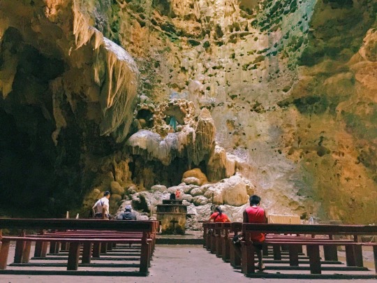
1ST STOP - CALLAO CAVE
From where you’ll be eating, you can ride a tricycle going to another tricycle terminal which will bring you to Callao Cave. Fare is for 20php. From the terminal, there are other modes of transportation going to Callao Cave but it’s very seldom. Best option would be to rent a tricycle. Fare would be much higher (in our case, 200php each and we were 3 so total of 600php) but the travel time would be for around 30 to 40 mins and the place is not that accessible. So the amount I paid is actually just fair.


Other fees you need to pay when you arrive at the venue would be:
Entrance Fee - 20php
Bangka Rental - 40php each
Tour Guide - 100php each
It’s actually really cheap when you’ll have this view after:

2ND STOP - PANSIT BATIL PATUNG
After exploring the whole cave, we went back to town to eat their famous pansit batil patung.

Don’t be deceived by its looks. This serving is actually for 3 people!
After trying my best to eat the whole plate, we decided to spend the night in Sta. Ana, Cagayan since we need to leave very early in the morning for the next stop. We were able to get a very cheap hotel for 1500php a night for 3 people: Eden’s Lodging Hotel. you can check their facebook here for details and pictures of the rooms.
Day 1 Expenses
Chowking breakfast - 120php
Tricycle to terminal of Callao Cave - 20php
Tricycle to Callao Cave - 600php (max of 4 people) ; 200php each
Entrance in Callao Cave - 20php
Bangka - 40php
Tour Guide - 100php
Ref Magnet (because you know) - 50php
Water - 20php
Pansit Batil Patung - 90php
Mt Dew - 32php
Tricycle to Terminal of Sta Ana - 10php
Van to Sta Ana - 180php
Eden’s Lodging House - 1500php ; 500php each
TOTAL: 1382PHP - $26.83
DAY 2
We woke up extra early since we needed to travel to the port of Sta. Ana where we will be riding a more than an hour boat ride to Palaui Island! We left the hostel we were staying at 4 in the morning and rode a tricycle going to the port. Tricycle ride will cost you 50php each (not bad for the distance you’ll actually travel). Once we arrived, we went to an office which handles tours to Palaui Island. The boat trip will cost you 850php back and forth. Quick reminder: since it’s located at the tip of Luzon, the boat ride will be challenging. The water’s not calm so you have to anticipate rough waters and high waves, but the people driving the motorboat are skilled so you’ll be able to reach the island safe but wet.


Wasn’t able to take much photos during the boat trip because I was scared that my camera would get thrown off the boat or I would get thrown off the boat. lol
After an hour of rough boat ride, we arrived in paradise. The local tour guide gave us a quick orientation about the history and topography of the island.
It is also with them that you need to pay 70php environmental fee and 100php each for the tour guide.

The view once you get off the boat.

And the hike begins. We did not have the proper footwear for this trip. We just had slippers and the bad news was it just rained so the hike was more challenging than what we expected. We badly wanted to see the famous Cape Engano Lighthouse which was used by early Filipinos to welcome incoming ships from the north.
Once you reach half of the hike you’ll have this majestic view:


At that moment, I just felt so lucky to be witnessing this beauty!

The entrance to the lighthouse.

Finally! After an almost hour of hike, we arrived here. And the bonus part was, we were the only people.
Now this was already breathtaking, but the view on the other side was much more than what we signed up for this trip.


Just casually sitting down and letting everything sink in. This is why I feel in love with discovering different places in the Philippines. When you think you’ve already seen everything, you’ll be surprised at how much more there is to see and explore!
Stayed here for hours when we decided we had to check one more hidden gem in this island before we head back.

Trail back down.

Don’t get tips from me about trekking and hiking. I’m not the best person to give advice. LOL

After 20 mins of trekking, this welcomed us!
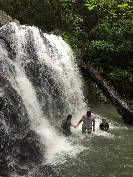
And of course, we can’t leave without taking a dip!
After a whole day tour in the island, we went back to our hostel. It was ‘leg day’ for us since we had to hike to the top of the island to see the famous lighthouse and to witness that breathtaking view, plus that waterfalls! Before we hit the sack, we went out to get some dinner. There are only a few stores near our hostel but we really didn’t mind because we just wanted something to eat and then sleep immediately. If you’re someone who really needs full meals, you can bring canned goods with you, or ask the hostel if they can cook for you. There’s also a restaurant nearby but it closes early.
Day 2 Expenses
Tricycle to Port - 50php
Boat ride - 850php (285php each)
Environmental Fee - 70php
Tour Guide - 100php
Tricycle back to Eden’s Lodge - 20php
TOTAL: 525php - $10.12
DAY 3
We woke up early the next day to commute going back to Tuguegarao. We needed to catch a van trip going to a friend’s house to get some free lodging and food. Sa buhay ngayon, importante ang mga ganitong bagay. Haha.
Before the trip, we decided to have brunch first. Rode a van back to Tuguegarao and another van to Piat, Cagayan where our friend lives. Spent the whole night there and decided to go back to Manila early morning the next day.
Day 3 Expenses
Brunch - 120php
Van to Tuguegarao - 180php
Tricycle to terminal of Piat - 20php
Van to Piat, Cagayan - 70php
Tricycle to termina back to Manila - 20php
Bus to Manila - 700php
Bus to Laguna - 71php
Jeepney - 8php
Tricycle to home - 20php
TOTAL: 1,209php - $23.30
TOTAL EXPENSES FOR THE WHOLE TRIP:
3,816php - $73.54
This trip will always be one of the most memorable for me. Got to tick this off my bucket list plus only spent less than what I usually spend on my trips.
#cagayanvalley#cagayan#callaocave#palauiisland#travel#explorethephilippines#itsmorefuninthephilippines#travel guide#travelguide#cagayantrip#cagayan trip#budget trip#budgetarian#lostinph
0 notes
Photo
Random photos @ Cape Engano Light House 🌱 (at Cape Engaño Lighthouse)
1 note
·
View note
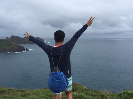
Photo


Day 3.1: Palaui, Ocean and Islets on the North End of Luzon
It was frighteningly beautiful. I have always been a lover of the ocean, and this time, we would be going against the tides on the northern end of Luzon. I can’t stop myself from imagining crazy things like what if at some point of the ocean, we would be finding a loophole in space and it would distort time and space which would unconsciously lead us to an alternate universe, or what if a giant sea monster came out, and those other kinds of idea. Haha.
Anyway, so for the third day of our backpacking adventure, we did island hopping in Palui with our motorboat. Of course, since there were only two of us, we had the whole motorboat on our own, and we didn’t need to catch up with the phase of other passengers.
We started going to Cape Engano Lighthouse. It was one of the oldest functional lighthouses in the country. It took us some uphill steps, but upon reaching the lighthouse itself, the whole view was majestic. We could see the islets and the vast ocean, and how the waves hug the shores, and how the sky kissed the waters. It was really breathtaking.
Our next destination was a calm peaceful clear-water beach known as Anguib. We took some time to splash into the waters, swim and float, and get some sunburns. The water was so clear and blue that it felt really refreshing to bounce in and out of the water.
Then, we headed to Punta Verde to hike up to their mini Balatubat Falls. Actually, the mother falls was hours up the mountain so we just decided to enjoy the really cool water and relaxing rush of the baby falls. We stayed there for quite sometime as the falling waters massaged our back with pressure. Haha.
After the falls, we went snorkeling on the diving site near Punta Verde. We had our fins, goggles and snorkels readied as the diver-guide toured us underwater. It was my first time so I was so amazed by the underwater civilization I saw. There were schools of fish swimming, and huge corals, and other various species. We even saw an open giant clam with its inner muscles, or whatever you call that, moving. Even thought it was straining to keep on swimming against the waves and having your body submerged into the water, the sight was really something to behold. We were even swimming together with the fishes. It was so so so beautiful.
Before going back to San Vicente Port, we headed to our last destination - Crocodile Island. The rock formation looked like a crocodile so there I was, imagining again that it was really huge crocodile but it was cursed so it was turned into stone. Oh well.
8 notes
·
View notes
Photo
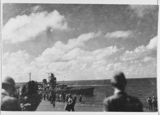
Battle off Cape Engano, 25 October 1944. Transferring Vice Admiral Ozawa's flag from the damaged Japanese aircraft carrier Zuikaku to the light cruiser Oyodo, 1100 hrs. on 25 October. Photographed from the listing Zuikaku's flight deck, with Oyodo approaching from her port quarter. [1280 x 925] Check this blog!
0 notes
Last Seen Blogs

worthless-chickenscratch
Miscellany

tirsden
we're all mad here

dirk-bat
Prettiest Boy You Ever Did See

lazymentalitylove
Meu cantinho

valeeriee
Sin título