#bottomland forests
Text
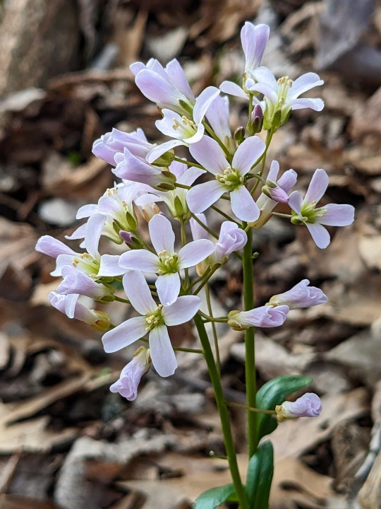
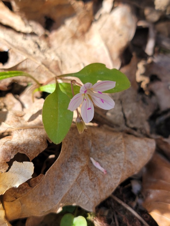
Purple Cress
Cardamine douglassii
Also known as Limestone Cress, this species in the mustard family features clusters of light purple flowers in early spring and can be found in wet and swampy forests with calcium carbonate rich soils. It's native to parts of the eastern United States and southern Ontario, Canada.
The plants I photographed are part of an isolated population remaining in a tiny bottomland forest remnant in St. Charles County, Missouri. Unfortunately, the rest of the forest has been lost due to suburban sprawl and what little of it remains has many invasive species, including winter creeper, callery pear, and japanese honeysuckle trying to encroach from surrounding developments and outcompete native plants like this one.
March 12th & 13th, 2024
St. Charles County, Missouri, USA
Olivia R. Myers
@oliviarosaline
#botany#cardamine douglassii#cardamine#purple cress#bittercress#brassicaceae#nature#naturecore#forest#fairycore#woods#missouri#native plants#native flowers#forests#hiking missouri#suburban sprawl#urban sprawl#ecology#plants#flowers#wildflowers#purple flowers#native plants of america#forest floor#bottomland woods#bottomland forests#nature photography#flower photography#spring
36 notes
·
View notes
Text
I love that of the three violets I planted in a barren but violet-friendly section of the back yard, the violet with just two leaves seems to have acclimated…
Two are V. sororia (she’s native) and one’s V. hederacea (if her runners take just pray for me)… predicting the hederacea will spread faster, but sororia goes crazy with late-season cleistogamy, and the ants might help her spread her reign.
#violets actually do grow here but most prefer the moist bottomlands :o) as opposed to drier habitats#so you’ll usually see them in older forests close to creeks and bayous that are seasonally wet but rarely fully inundated#they die back when it gets hot but are actually pretty hardy perennials#I hope they take because they make good ground cover where grass won’t grow
0 notes
Text
Inktober Days 22-24
Day 22: "Scratchy"

Saguaro, cholla, prickly pear, pincushion, hedgehog, barrel cactus—how magical are these amazing plants? Iconic, unique, perfectly tuned to their environment. The pleats on a saguaro help it bulge and shrink to accommodate water availability, and the inhospitable trunks provide shelter for desert birds.
Saguaro NP produces some of my favorite educational videos in the system, thanks in part to Feature Fridays with Ranger Freddy Gutiérrez Fernández-Ramírez. Just to add to the scritchy-scratchy theme of this prompt, some of the more unusual videos featuring Ranger Freddy show how to remove jumping cholla barbs from your skin and clothes. Rangers in Saguaro carry hair combs in their first aid kits—and it’s not to fix flat-hat hair!
Day 23: "Celestial"

In recent decades, park managers have come to recognize natural soundscapes and pristine night skies as tangible resources, just like clean air, land, and water. As I was entering the NPS field, a big effort was kicking off to designate certain units as Dark Sky parks, and Big Bend is the king of them all. It has the lowest levels of light pollution of any park in the lower 48 and is famous across the NPS for its breathtaking starscapes.
Protecting natural darkness opens up amazing new opportunities for visitors and rangers. I love assisting with night sky programs, because I remember how I felt when I first traveled away from the greater I-85 corridor and saw my first pristine night sky. It’s a primordial type of magic to see stars unveiled from urban lights and humid haze. And the good news is, unlike other endangered resources, dark skies are salvageable. When towns and cities take steps to reduce their light and air pollution, there’s no slow, agonizing recovery—the stars come right back. They’re just up there, waiting to peek at us again.
Day 24: "Shallow"

I have to confess—I used to look down on Congaree, despite it being the only national park in my home state of South Carolina. I thought of it as muggy, buggy, and a bit boring. But when I was researching wetland habitat for A Field Guide to Mermaids, I was stunned to realize just how special this landscape is. Our country used to be covered in immense floodplain forests along river corridors, but the natural flood cycles that made these lowlands so fertile also meant the land was prized for agriculture. Rivers were straightened, forests were cut down, and the rich soil was planted with crops. Because of this, Congaree protects the largest swathe of bottomland floodplain forest left in the United States.
And it’s a gorgeous park, as well. There’s something evocative and eerie about walking the elevated boardwalks over tea-colored water. Spooky cypress knees reach up through the water like outstretched arms, and several massive national and state champion trees loom up out of the thick forest.
This park may not have the accolades some of the grander, more storied parks have, but I’m proud that it’s my home state’s park and glad that it protects one of the last intact forests of its kind.
------
Another big thank you to the folks who have preordered Thirty-One Days of National Parks: The Artbook! The Big Bend page features a little guide to starhopping from the Big Dipper out to other stars!
103 notes
·
View notes
Text
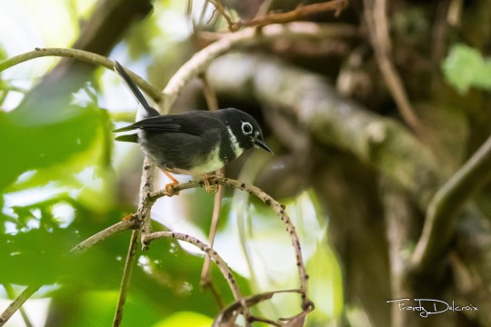
Warbler Showdown; Bracket 9, Poll 3

Swainson's Warbler (Limnothlypis swainsonii)
IUCN Rating: Least Concern
Range: migrant; breeds in the Southeast and overwinters in the Caribbean, as well as the Yucatan Peninsula
Habitat: prefers a dense understory with lots of leaf litter and few herbaceous ground cover. Breeds in bottomland hardwood and montane forests, and early-growth seral pine stands, but is less picky when overwintering.
Subspecies: none
Whistling Warbler (Catharopeza bishopi)
IUCN Rating: Endangered
Range: resident; St. Vincent island
Habitat: primary growth montane forests, especially those thick with undergrowth.
Subspecies: none
Image Sources: Swainson (Dorian Anderson) Whistling (Frantz Delcroix)
#NWW Showdown#swainsons warbler#whistling warbler#parulidae#passeriformes#wood warblers#new world warbler
16 notes
·
View notes
Text
Dragons, By Devin Johnston
We gathered in a field southwest of town,
several hundred hauling coolers
and folding chairs along a gravel road
dry in August, two ruts of soft dust
that soaked into our clothes
and rose in plumes behind us.
By noon we could discern their massive coils
emerging from a bale of cloud,
scales scattering crescent dapples
through walnut fronds,
the light polarized, each leaf tip in focus.
As their bodies blotted out the sun,
the forest faded to silverpoint.
A current of cool air
extended from the bottomlands
an intimation of October,
and the bowl of sky deepened
its celestial archaeology.
Their tails, like banners of a vast army,
swept past Orion and his retinue
to sighs and scattered applause,
the faint wail of a child crying.
In half an hour they had passed on
in search of deep waters.
Before our company dispersed,
dust whirling in the wind,
we planned to meet again in seven years
for the next known migration.
Sunlight flashed on windshields
and caught along the riverbank
a cloudy, keeled scale
about the size of a dinner plate,
cool as blanc de Chine
in the heat of the afternoon.
#IT"S APPRECIATE A DRAGON DAY BABYYYYYY#I had wondered why one of my poem a day emails was about dragons#And it was so much fun I wanted to share#Dragon#Dragons#Appreciate a Dragon Day#Poem#Poetry#Words
14 notes
·
View notes
Text
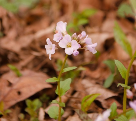
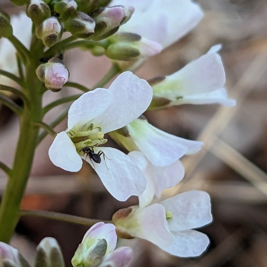
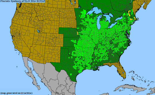
Rich woods, bluffs, mesic bottomland forests, rocky hillsides, floodplains, seepage of bogs, springy areas.
Colors range from purple to a purplish white, it is important to note that entirely white petals are rare among this species. The flowers are borne in a raceme and are typically born in early spring from mid-March to late April. ❤️🌸
#awesome#photography#nature#nature photography#photography is magic#spring photography#spring vibes#woods#flowers#wildflowers
11 notes
·
View notes
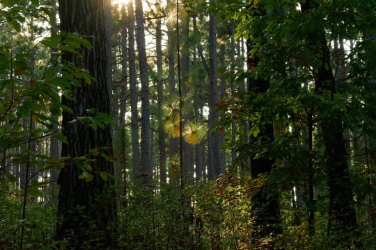
Text
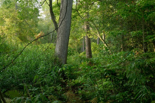
Bottomland Forest, Weymouth Wood Tract
9 notes
·
View notes
Text
updated environment of Western Beleriand part one
Flora, fauna, geography and environment masterlist
Disclaimer: I used both what we can extrapolate is likely indigenous to the region based on descriptions of the landscape and climate as well as my own headcanons and inspirations and reference books on similar habitats as well as books like The Atlas of Middle Earth and The Flora of Middle Earth
Please feel free to ask about any of this, it’d very much a brief overview
Important note: this post is meant to be about the environment in canon with some of my own ideas! That being said Tolkien had obvious bias in his environmental imaginings and I love to explore Beleriand as inspired by other locations! Please feel free to send requests for that!
-Western Beleriand was divided from the East by the River Sirion. It faced the sea to the West.
-Western Beleriand encompasses the coastal regions of Nevrast, the Havens of the Falas and Arvernien. It also includes the landlocked region of Nargothrond, Brethil, parts of Doriath and the woods of Nuath. Some maps and accounts also include Hithlum though this is often considered a region north of Greater Beleriand.
-The River Sirion has two tributaries in western Beleriand, River Narog and River Teglin. Both of these have tributaries of their own.
-Narog was the Southernmost tributary and was one of the largest rivers in Western Beleriand and is the largest of the tributaries to the River Sirion
Ginglith was one tributary to Narog, sourced in wells in the small forest of Núath. It bordered Tumhalad on the West and met Narog some ways North of Nargothrond.
Ringwil, another tributary to Narog was sourced from hills around Nargothrond and ran through the forest Taur-en-Faroth. It was tiny.
-Teglin/Taeglin both met the River Sirion on the borders of Doriath, Teglin flowed from the West through Brethil. Teglin was one of the larger tributaries and had several of its own.
-Celebros meaning ‘silver foam’ was a tributary to Taeglin. It met Taeglin on the western border of Brethil and ran through the forest. At the gorge of Cabed-en-Aras (leap of the deer) near where Celebros met Teglin, Glaurung was slain by Túrin and Niënor took her own life afterwards. The ravine was renamed Cabed Naeramarth or the leap of dreadful doom.
-Maudlin, meaning Golden River, was another tributary to Teglin and ran Northeast to Brethil. Glithui was the third tributary to Teglin and began in the Ered Wethrin from around Amon Darthir. On the other side of this mountain, the source of Nen Lalaith was located.
--One estimate from The Lost Road puts the region at 99 leagues across at its widest but this is not considered Canon and Tolkien often had difficulties in his numerical estimations
My own thoughts!
--Given the descriptions of the region and the different habitats, it is likely a temperate region with temperate coastal parts. That being said, the descriptions are often vague enough that the environment of many different real life places can be explored through it. For example, a Mediterranean climate would fit many of the coastal regions, and Mediterranean forest and scrublands could fit the more inland regions. In real life examples of this can be found throughout coastal Europe, parts of Asia and north Africa, and parts of Australia and New Zealand
-Parts of the river Narog flow underground and have species not found elsewhere in Beleriand outside of the deeper realms of Angband rarely considered by its own inhabitants. On a similar note, Nargothrond is one of the main places outside these deeper parts of Angband (not including marine life) where bioluminescence is found. There are a few bioluminescent species in Menengroth, Nan Tathren, the caves of Nevrast and western Dor-lómin, and Nan Emloth as well.
-West Beleriand consisted of lowlands and bottomlands (the usually flatter floodlands along a watercourse), plains and hilly areas and moorlands. There were also more scattered forested areas and woodlands, as well as the denser Forest of Brethil.
-Resources, imports and goods differ from region to region but overall some of the most prominent resources are timber, clay, wool, orchard fruits, flint, and salt.
-Due to the coastal areas some of the most prominent and advanced shipwrights, cartographers and navigators, and fishers are also found. Many of the coastal communities have studied and mapped the stars as well (I think I have something about this on my post and Barad Nimras)
-The climate was mild though humid without either harsh winters or hotter summers. Colder fronts did occasionally arise from the Encircling Mountains however. The coastal regions, especially around Nevrast, are somewhat warmer and gentler.
-Biodiversity is highest in coastal regions and in the surrounding marshlands.
17 notes
·
View notes
Text

@actualblanketgremlin stoke the fire, pull up a chair, draw the blanket round your shoulders. do not heed the tap at the window.
lost ships. haunted beaches. wildfires and mother bears. getting older. starting this post was a slap in the face at first because I had to conclude I've had this blog almost ten years. I entered this sphere of the internet in an age where everything had a neat label and correspondence-- and I could have never written about the great lakes back then. their spirits are ancient and wild, inland seas that cast off anyone's bridle.
I spoke on Superior being a psychopomp, but it's lake michigan with the most recorded drownings in her waters. it helps that she borders chicago, and besides the city it also has the most developed shoreline for tourists. I spent every childhood summer there, camping in the dunes. the crashing waves call to you all night until you wake to their sound in the morning.
we all believe in the spirits here, but whether you do or not you are compelled to agree that the lake is haunted. sometimes we just don't recognize a ghost staring us in the face. when the great lakes were some of the country's busiest trading routes there were great ships crossing back and forth day and night-- and some of these the lake never gave back. michigan.org talks about the lost ships we managed to find and cling to:
"The bottomland of the Great Lakes is a time capsule of another era, with thousands of lost schooners, steamers and barges carefully preserved by the cold, fresh waters. They're also now preserved by the Michigan Underwater Preserve System, created by legislation in 1980 that preserves them for generations by making it a felony to remove portholes, anchors, even a fork from a wreck within."
now you can find some with just a snorkel-- if you feel ready to look in the mirror. with all of the wrecks we honor, there is a lingering presence beyond the horizon of the souls we never found. did you know we have our own bermuda triangle of lost things? the michigan triangle is said to stretch from around ludington down to benton harbor or so, and then its third point concludes across the lake in wisconsin. the violent storms in this region have swallowed ships and planes throughout the history of colonization in the area. what do you need accomplished so badly that you would cross a sea of storms to see it achieved? can you confront and embrace that kind of power in your life without letting arrogance drag you to the depths? this is the type of working you can bring to her.
there's an anishinaabe legend that I assume was read aloud to everyone who went to public school in michigan. in ancient wisconsin a mother bear and her two cubs were trapped on the shoreline of lake michigan as the forest they lived in burned to ash. in a desperate bid to save her young, she led them into the water and they began to swim. as they were nearing the opposite shore (about 118 miles later) her struggling cubs succumbed to the depths and drowned. the mother bear reached the shore and collapsed facing the lake, waiting for her cubs that would never come. the Great Spirit took pity on her after watching the events unfold. They raised the cubs from the depths and turned them into the North and South Manitou Islands. the mother bear became the Sleeping Bear Dune, an ecological highlight that still waits for her cubs to this day. can you define a maternal energy in your life? who would you address as mother and what protections can that bring? if nothing else just go climb the dune, the view is worth it.
this post is getting long so I'm going to stick with this maternal discussion, which leans into is very upg. I take from lake michigan a high priestess/suit of cups energy which aligns well with a lot of the hekatean rites I make up. in lighter magic I have drawn a lot of healing energy from this lake and I think others would say the same. I'm not really in the "thin veil" crowd but many lake michigan beaches are a gorgeous, powerful place to make an outdoor altar and connect with both ancestors and the locals. use the driftwood and stones of every color. consulting your preferred divination tool on the shore can reveal very interesting threads. storm water collected respectfully from this lake has shattering results-- good luck collecting it.
choose your own adventure on lake michigan. I leave out years' worth of stories-- ghost towns, lights in the woods, the time I found the Hunt. along with many afternoons on a towel with a good book. if visiting for spiritual purposes, take care in putting up your protections, and that includes sunscreen! 💋

(planning to write more of these about michigan but hearing interest or perhaps requests is nice!)
22 notes
·
View notes
Photo
Broad leaf or Carolina spring Beaut’
Claytonia caroliniana
Virginia spring beaut leaves in background just starting to leaf out
Claytonia virginica
Photographed in RRG in mixed mesophytic woodland, Carolina spring beaut has a few great lakes region United States pops and is mainly found in the core regions of the Appalachian Mountains. A true disjunction as a lower ozark plat pop is in Arkansas; where as the rich alkaline mesic woods and bottomland forests are packed with Virginia spring beaut until you hit semi arid regions and where the central plains starts becoming the rocky mountain region.

26 notes
·
View notes
Text
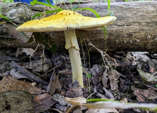
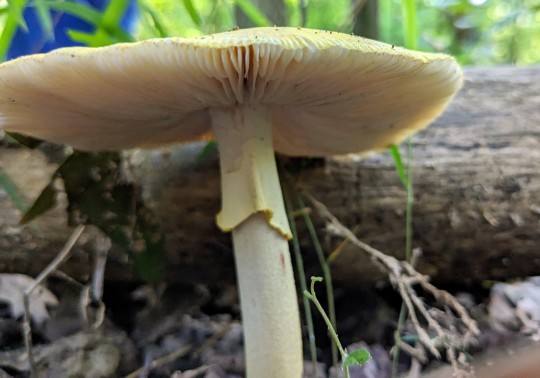
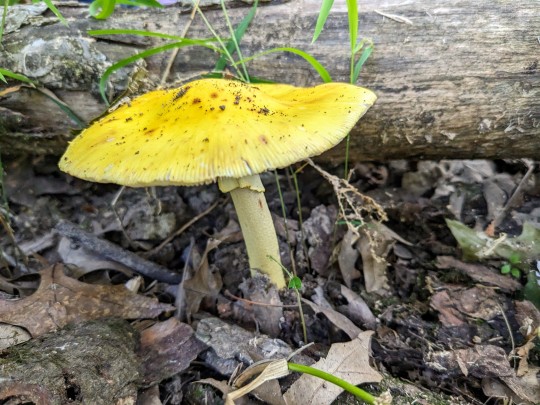
Amanita section Validae
I found this gorgeous, lemon yellow amanita mushroom in a healthy bottomland forest surrounded by pin oaks, river birches, and American elms.
July 26th, 2023
Arnold, Jefferson County, Missouri, USA
Olivia R. Myers
@oliviarosaline
#mycology#Amanita Sect. Validae#amanita mushrooms#amanita#nature#woods#naturecore#forest floor#fairycore#missouri#cottagecore#ozarks#the ozarks#forest#mushrooms#fungi#wild fungi#wild mushrooms#bottomland woods#naturalist#mushroomcore#yellow mushrooms#mushroom photography#nature photography#fungi photography#exploring the woods#mushroom#toadstool
45 notes
·
View notes
Text
Excerpt from this press release from the Department of the Interior:
The Department of the Interior today announced the expansion of four existing national wildlife refuges, which will allow for the voluntary conservation of up to 1.13 million acres of wildlife habitat in New Mexico, North Carolina and Texas.
Investing in and expanding the National Wildlife Refuge System, managed by the U.S. Fish and Wildlife Service, furthers the Biden-Harris administration’s work to support community-driven efforts to conserve and restore the nation’s lands and waters through the America the Beautiful initiative. Under Secretary Haaland’s leadership, the Department has also established four new Refuges that will help conserve important fish and wildlife habitat, support working lands, and expand opportunities for outdoor recreation.
The new expansion areas include:
Roanoke River National Wildlife Refuge (NC) may now conserve up to 287,000 acres of floodplain habitat along a 137-mile stretch of the Roanoke River from Weldon to the Albemarle Sound, to support rare and at-risk species like the Atlantic sturgeon, cerulean and Swainson's warbers, bald eagles and migratory waterfowl. The refuge was established in 1991 to protect the forests in the Roanoke River floodplain, considered to be the largest intact, and least disturbed, bottomland forest ecosystem remaining in the mid-Atlantic region.
Aransas and Big Boggy National Wildlife Refuges (TX) may now conserve up to 150,000 additional acres of habitat in the Gulf Coast Prairies and Marshes ecoregion of Texas to support whooping crane, Eastern black rail, Attwater's prairie chicken, mottled duck and other wintering waterfowl. Established in 1937, Aransas NWR serves as a refuge and breeding ground and for migratory birds and other wildlife and is best known as the wintering home of the last wild flock of endangered whooping cranes. Establishing in 1983 and designated an Internationally Significant Shorebird Site by the Western Hemisphere Shorebird Reserve Network, Big Boggy NWR is a stronghold for the threatened eastern black rail and provides seasonal and year-round habitat for large populations of waterfowl, wading birds, waterbirds, and shorebirds.
Muleshoe National Wildlife Refuge (NM and TX) may now conserve up to 700,000 acres of habitat in the Southern High Plains along the Texas-New Mexico border to support sandhill crane, pronghorn and lesser prairie chicken, as well as a full suite of other wildlife that rely on the grasslands, playa wetlands and saline lake habitats of the Central Grasslands. Established in 1935, the refuge is the oldest national wildlife refuge in Texas and is best known for hosting one of the largest concentrations of lesser sandhill cranes in North America.
The four final Land Protection Plans for these expansions were developed through public processes and informed by input from local landowners, Tribal leaders, state wildlife agencies, and other stakeholders. The Plans outline land protection priorities for these refuges that will inform the Service’s interest in acquiring parcels from landowners who are willing to sell property (fee-title) or property rights (conservation easements or cooperative agreements) through purchase or donation.
4 notes
·
View notes
Photo

Scientific Name: Chasmanthium latifolium
Common Name(s): Inland sea oats, inland wood oats
Family: Poaceae (grass)
Life Cycle: Perennial
Leaf Retention: Deciduous
Habit: Graminoid
USDA L48 Native Status: Native
Location: Plano, Texas
Season(s): Fall
When I first heard the name “inland sea oats,” I wondered if it was an oat that grew near an inland sea or if it was some variant of a sea oat that grew inland. Short answer: it’s the latter. Sort of. Then it gets complicated. For starters, there are more names. This plant must’ve hit the jackpot in the common name lottery, because, in addition to inland sea oats and inland wood oats, it’s also called river oats, wood oats (without the “inland”), Indian wood oats, upland oats, wild oats, northern sea oats, plus regional variations, and endless permutations of all these.
This is a shade-tolerant plant native to the southeastern U.S., as shown by the green-tinted areas in the USDA map below. It is found along riverbanks, on floodplains, and in bottomland forests, giving rise to the names “river oats” and “wood oats.”
Its seedheads resemble those of sea oats (Uniola paniculata), which grows on coastal sands. However, since this species is not a coastal plant, the combination of its similar appearance but dissimilar habitat get mashed together into the awkward name “inland sea oats.” As both of these plants were once classified under the same genus (Uniola), it’s not clear to me if they’re as genetically distinct as the separate genera would suggest. So the slightly longer answer to my original question is: it’s a maybe, maybe-not sea oat that grows inland.
However, neither plant has ever been associated with Avena, which is the genus to which our breakfast oats belong. I thnk using the name “wild oats” on this plant is just going to cause confusion, because the farmed oat (Avena sativa) has a wild relative (Avena fatua), and its common name is — wait for it — wild oat.
It should be clear by now that common names can be unreliable, but perhaps the most nonsensical one here is “northern sea oats,” because this species is not native to the north, not a seaside plant, and not an oat. How anyone came up with that name is a complete mystery to me.

#Chasmanthium latifolium#inland sea oats#inland wood oats#Poaceae#perennial#deciduous#graminoid#native#Plano#Texas#fall#autumn#fruit#brown#tan#plantblr
6 notes
·
View notes
Text
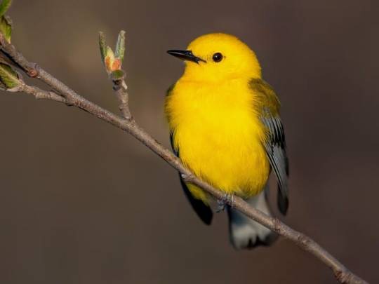
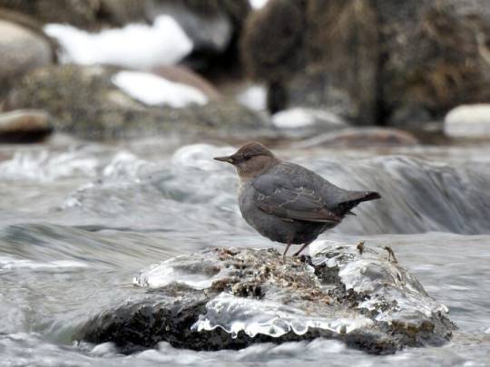
Round 3, Poll 1
Prothonotary Warbler vs American Dipper
sources under cut
Prothonotary Warbler
"Truly a sleeper warbler. Classy color scheme, lots of spunk. We saw a handful at Magee Marsh last month and I've been calling him America's little darling ever since."
"prothonotary warblers are an indicator species for healthy bottomland hardwood forests in the lower Mississippi"
The only Eastern warbler that uses cavity nests! There are only two warbler species- out of 117!- that use cavities like nest boxes or old woodpecker nests.
American Dipper
"absolutely absurd to see them swim up-current. they're like fish to me. also i love their bounciness"
hey so who decided to let a songbird get in the water?? Most birds associated with water belong to the non-passerine families, but dippers decided no one else was jumping in those cold mountain streams and decided to do it themselves.
"They have even been known to place their nests behind waterfalls, so the birds must fly straight through falling water to access them."
22 notes
·
View notes
Text

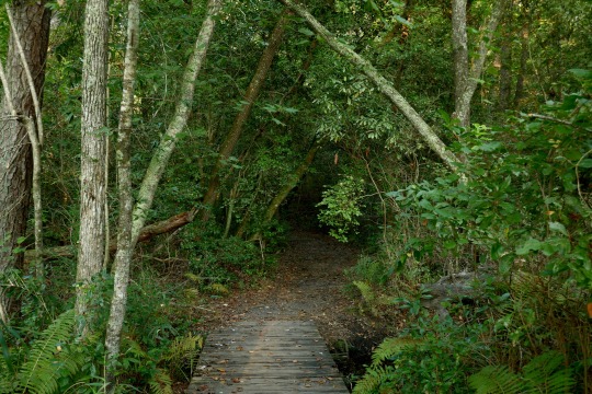
A Few Steps Along Lighter Stump Trail, Weymouth Woods
At times the forest seems like a house—light and airy rooms above, ceilings high enough to accommodate the height of pines singing in the wind, but then take the stairs down to the basement, light retreats into shadow and the walls lean-in, down there a cellar full of hardwoods and vines talking about bottomland life as they sip on sedate waters.
6 notes
·
View notes
Photo
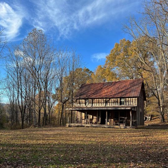
Abandoned Farmhouse #LifesTrails #AdventureCreatively #daily #adventure #abandoned #abandonedplaces #farmhouse #farm #Beautifuldestinations #vacations #discover #explorepage #exploremore #explore #hiking #mountains #outdoors #outside #gooutside #forest #photography #photooftheday #nature #northcarolina #otto #franklin #asheville #vacation #travel #travelgram (at Tessentee Bottomland Preserve) https://www.instagram.com/p/CkPQrk6sBAb/?igshid=NGJjMDIxMWI=
#lifestrails#adventurecreatively#daily#adventure#abandoned#abandonedplaces#farmhouse#farm#beautifuldestinations#vacations#discover#explorepage#exploremore#explore#hiking#mountains#outdoors#outside#gooutside#forest#photography#photooftheday#nature#northcarolina#otto#franklin#asheville#vacation#travel#travelgram
5 notes
·
View notes
Last Seen Blogs

kitakamis-best-ogre
Ogerpon

thegabecole
Gabe

my-past-disgusts-me
stink binker

giuliodilemmi
GIULIO DILEMMI'S OFFICIAL TUMBLR

miltacos
#1000tacos2015