#bettergeology
Text
(Lava) Bomb on the Mountain (volcano)
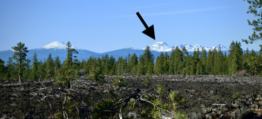
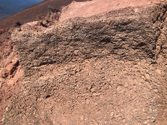
South Sister is Oregon's 3rd tallest peak. It's a stratovolcano 10,363 ft (3,158 m) tall, part of the Three Sisters complex which includes dozens of smaller volcanoes and several older eroded mountains.
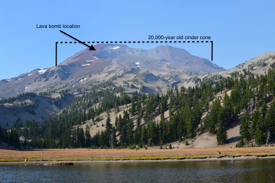
The upper 2,000 feet or so (~650 m) is a 20,000 year-old cinder cone, the result of a fire-fountain-type eruption of lava. One of the common features of that style of eruption are lava bombs - chunks of liquid lava flung through the air that cool in streamlined and elongated shapes. The upper flank of the mountain is very steep, and makes for slow climbing through cinders. Slope pitches average 30˚ in this area, and get as high as 58˚!
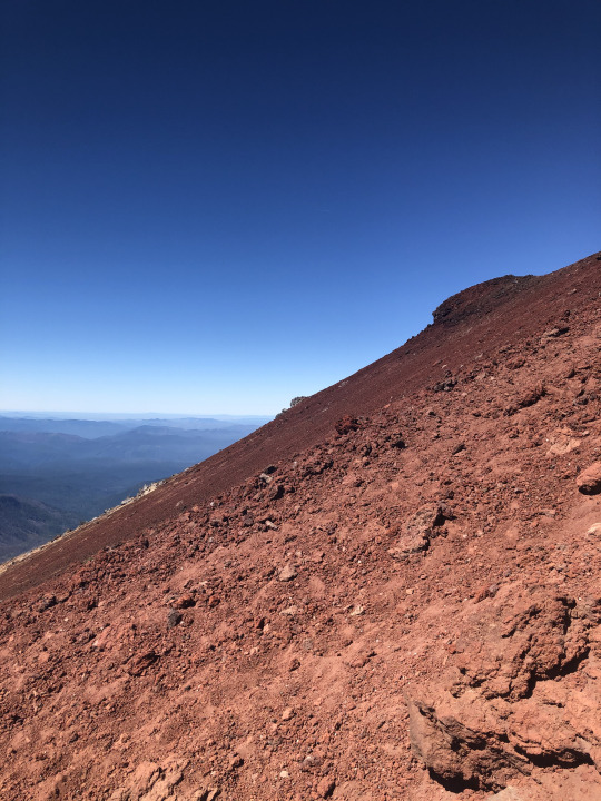
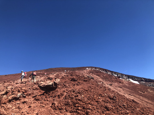
Perched at random on this slope is probably the largest lava bomb I've ever seen! It's probably about a meter across and shows the streamlined, elongated nature of a bomb very well. I'm not sure why it's still sitting at that precarious location, but up close you can see the vesicular texture of erupted lava (basaltic andesite). This might be classified (yes, there are sub-classifications of lava bombs - geologists love classifications!) as a breadcrust bomb because it looks almost like a crusty bread with cracked crust. These are very common on volcanoes like this. It's hard to see in this picture, but amidst the vesicles (bubbles) in the rock are numerous plagioclase feldspar crystals ~0.5-1 mm across.

Anyway, volcanoes are cool.
#oregon#geology#pacific northwest#bettergeology#rocks#volcano#three sisters#deschutes#lava#basalt#cascade volcanoes#high cascades#cascadia#pnwexplored#mountain climbing#mountains#hiking#outdoors#nature#geology is cool#adventures
169 notes
·
View notes
Text
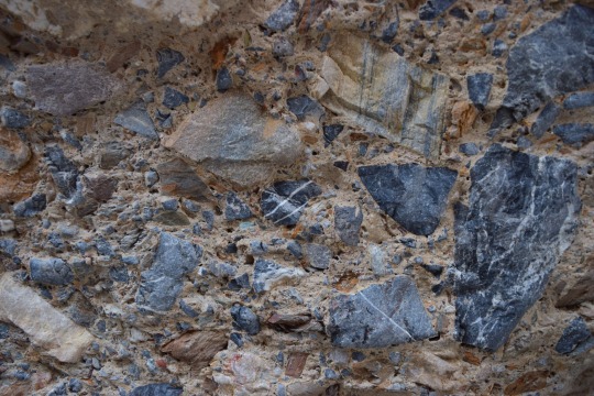
Debris-flow breccia, Mosaic Canyon, Seath Valley National Park, California, USA.
#geology#photography#california#bettergeology#rocks#death valley geology#death valley national park#california geology
53 notes
·
View notes
Text
youtube
Much of western Washington's recent geology has been dominated by giant ice sheets stretching from the Canadian Rockies to central Washington. This ice gouged out the Salish Sea, Puget Sound, and carved up the rest of the landscape. Port Townsend sits on a peninsula made up of the junk giant glaciers left behind. This is typically sandstone, gravel, and mud but weird stuff starts happening when the giant glacier meets the ocean and starts to melt. There's lots of cool geology in Port Townsend, once you know where to look!
#BetterGeology#geology#geology video#science video#science#earth science#nature video#video#youtube#glacier#washington geology#Glacier#glaciology#ice age#cordillera#olympic peninsula#port townsend#PNW#Pacific Northwest#Youtube
67 notes
·
View notes
Text
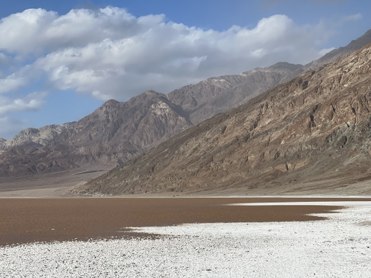

Taking a stroll in the ephemeral brines of Death Valley.
As a basin completely isolated from the sea, Death Valley is the ultimate sink and final destination for all of the surface and groundwater for an immense area of eastern California and central Nevada. Following an unusually wet summer and winter of 2023/2024, a lake as deep as 3 feet filled the salt pan on the flood of Death Valley and brought back a glimpse of how it must have looked when the valley contained a permanent lake in the geologic past.
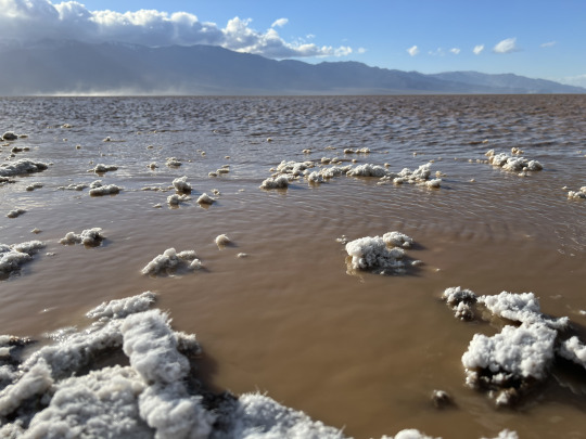
Strong winds during my last visit actually pushed the lake some two miles to the north, churning up the sediment and mud of the lake bottom and turning the water to the color and consistency of chocolate milk. As the salty water evaporates from the surrounding mud, it draws the salt into long, threadlike crystals that turn the salt flats fuzzy for a brief time.


37 notes
·
View notes
Text
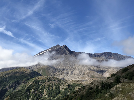
Keeping an eye out

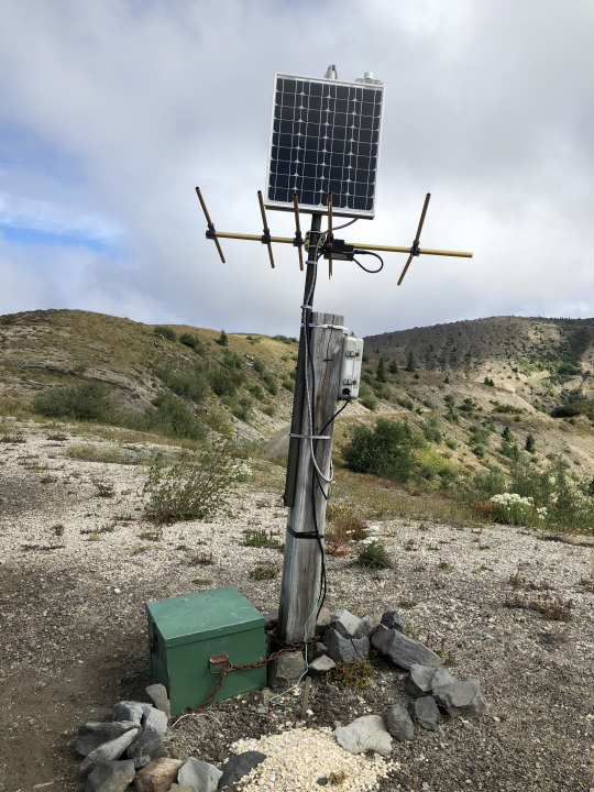
Mount St. Helens is the most active volcano in the Cascades. It's major eruption in 1980 has been succeeded by about 10 other smaller eruptions and maintains near-constant microseismicity. The first pictures show one of the close-in monitoring stations at Windy Ridge. The USGS Cascade Volcano Observatory maintains a number of large monitoring stations close to the mountain, near the vent, where they've been armored to protect from eruptive activity. These stations typically include a seismometer (seismogram here), a GPS station (the white dome), and other equipment like geophones or a webcam. Volcanoes never erupt spontaneously, they are always preceded by some kind of activity - usually small earthquakes - and let you know when they're ready to go. St. Helens hasn't done anything since about 2010, taking a well-deserved rest after the major lava dome growth in 2004-2008.

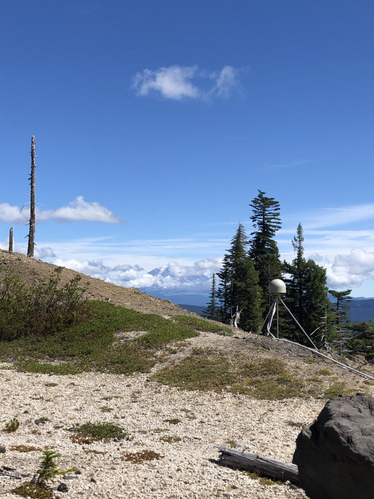
Around the mountain to the southeast, you can hike through the Plains of Abraham's pumice fields and past the slot-canyon head of Ape Canyon to the rim of the Muddy River, where another monitoring station reports seismicity and GPS data. The GPS stations observe the shape of the volcano over time. As gas, fluids, and magma move around inside the mountain, the surface deforms. Rapid or dramatic deformation is often indicative of impending eruption or other activity, and is one of the most important parameters in the volcanologists' arsenal.
#geology#pacific northwest#washington state#washington geology#mount st helens#volcano#cascade volcanoes#gifford pinchot national forest#volcanology#geohazard#loowit#bettergeology#adventures
36 notes
·
View notes
Text

Basalt columns in basalt of Newberry Volcano, lower Crooked River Gorge, central Oregon. Each one is 60-120 cm across (2-4 feet).
#oregon#geology#photography#pacific northwest#bettergeology#rocks#oregon geology#basalt#basalt columns#central oregon
35 notes
·
View notes
Text
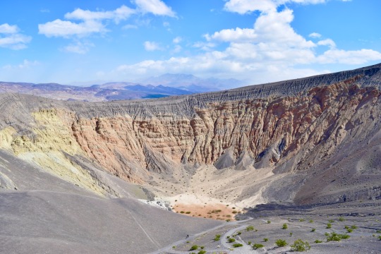

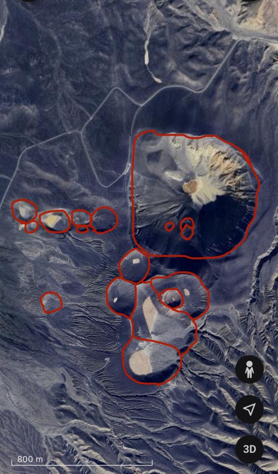
Ubehebe Crater
At the north end of Death Valley sits a small volcanic field. About 2,100 years ago, a body of basaltic magma forced its way to the surface along the Tin Mountain Fault, reaching the surface near the floor of Death Valley.
2,100 years ago, Death Valley was a different place. It more closely resembled the rest of the Mojave Desert's scrubby vegetation, and cooler temperatures allowed for more water to be present across the region. A shallow lake permanently occupied what is now called Badwater Basin, and other marshy regions were found along the length of Death Valley. As the body of basaltic magma rose to the surface, it encountered the significant groundwater deposits present. When lava meets water, explosive things happen.
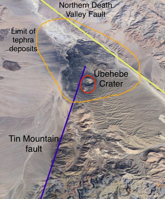
(looking SW along the Tin Mtn. Fault)
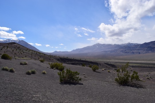
A phreatomagmatic eruption occurs when magma encounters water and creates a near-continuous steam explosion. Ubehebe Craters consists of about 15 explosion craters, called maars. These many craters probably all formed about the same time, with the main Ubehebe Crater being the last one formed and therefore not filled with volcanic ejecta and debris. As the steam-magma slurry rose, it blasted through the surrounding rock which is a conglomerate composed of solidified alluvial fans coming off the surrounding mountains. Of the material erupted and thrown across the landscape, only about 1/3 of it is lava! The dark blanket surrounding the volcanic field consists mostly of fragments of this conglomerate baked and altered by its proximity to lava. You can find basaltic cinders with chunks of conglomerate trapped within, often baked orange or white by the heat.
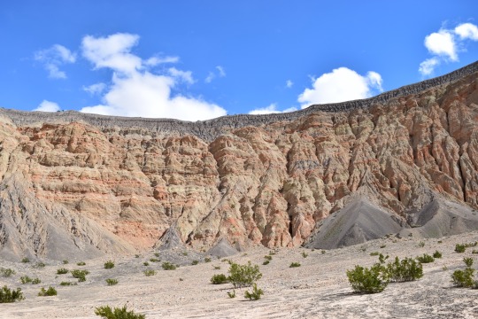
The main Ubehebe Crater is quite large, about 800 m wide (1/2 a mile) and 270 m deep (800 feet). There's a steep and slippery path to the bottom, from which you can get a true appreciation of the size and power available in the inside of a volcano. The surrounding layers of alluvial conglomerate are faulted and cooked, showing that this area has seen some intense geologic activity in its lifetime.


Brown and gray layers show the surge deposits left by individual explosions during the eruptive period which probably lasted between a few days and several weeks. They sit directly atop the preexisting arroyo/bajada/alluvial fan surfaces.
#geology#california#adventures#rocks#bettergeology#photography#death valley#volcano#california geology#mojave desert#nationalpark#eastern california#lava
22 notes
·
View notes
Text
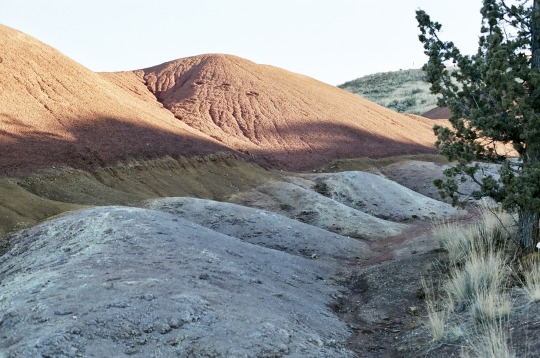
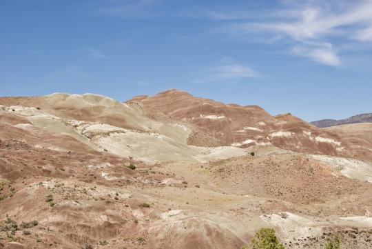
Colorful Clays of the Painted Hills area

The Painted Hills are one of the most popular and well-known of Oregon's scenic treasures. The towering ridges of yellow, red, and black clays reveal part of the complex geologic story of Oregon when the area was a tropical rainforest, or a hardwood temperate forest, or a volcanic hellscape at different times. The different bands and layers are folded, warped, and faulted by complex plate tectonics. Here though, at Painted Cove just behind the main Painted Hills viewpoint, the story is just a little different.

Painted Cove is a couple of shallow gullies linked in a loop by a boardwalk and trail. In here, you pass through areas of bold red and yellow clays before reaching a gully flanked with a light purple rock. The light purple is of a completely different origin than the clays, which are effectively fossilized soil layers.
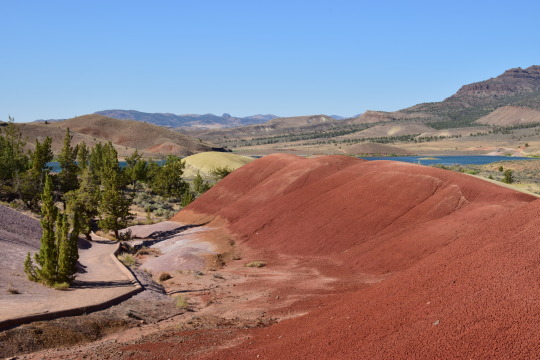
This is a weathered outcrop of rhyolite lava, a lava composition that is mostly quartz by mass. This area grades from purple to brown to red. This is an actual preserved soil horizon. If you dig a hole, you go through different soil horizons - or chemical and physical conditions - before you reach bedrock. Commonly these are O (for organic-rich), A, B, and C. B and C are closest to bedrock and include chunks of weathered, eroded source rock. Here, the purple is that C horizon, then the brown layer is B, and the red is an A horizon mantling the rhyolite lava flow. This whole stack of soil is somewhere around 25 million years old!
This is one of my favorite rock outcrops in all of Oregon because of how elegantly and simply it displays soil development processes from more than 25 million years ago!
(A note for other geologists: my soil horizon analogy isn't completely accurate since these paleosols have different classifications than regular young soils do, and I'm not very well-versed in those at all)
If you're in to photography, these are (with the exception of the 2nd to last shot) shot on Fuji Color 400 with my Nikon FM2.
#oregon#geology#photography#pacific northwest#bettergeology#adventures#rocks#fujifilm#photographers on tumblr#nikon#film photography#central oregon#eastern oregon#painted hills#john day fossil beds national monument#john day fossil beds
20 notes
·
View notes
Text
All natural fudge swirls

In this remote canyon of Eastern Oregon, claystone has eroded into barren badlands and mounds. The mineral content of the clays, which are the fossil remains of 30 million year-old rainforest soil, is rich in iron oxide and clay minerals that form in warm, wet conditions. The white stripes, which resemble marshmallow cream in a chocolate sundae, are ash deposits from volcanic eruptions that covered the landscape in thick layers of volcanic debris.
The dry, hot conditions of this area of Oregon are already unfavorable to any plants other than grass, sagebrush, and juniper. If you take away soil, add steep slopes and impermeable clay, then you get barren badlands slowly eroding into whimsical mounds. The layers are folded and faulted, which adds to the complexity of the white stripes. What once was nicely ordered is now a mind-boggling puzzle of different layers.
#oregon#geology#pacific northwest#bettergeology#rocks#clay#ice cream#eastern oregon#john day fossil beds#soil#jeep#adventures#oregon desert
19 notes
·
View notes
Text

youtube
While it's easy to mistake this outcrop for the Painted Hills, this is actually older rock of a very similar origin. To summarize, this red claystone is a geologic library of ancient climate. The various minerals and microfossils found in this red clay tell a story of a time when Oregon was a volcano dominated subtropical rainforest. This is rock older than the Cascade Mountains! What exactly can we learn from it? Find out on BetterGeology!
#geology#oregon#pacific northwest#rocks#oregon geology#bettergeology#science video#geology video#videos#clay#central oregon#john day fossil beds#Youtube
10 notes
·
View notes
Text
High flow on the Trukee River through downtown Reno, May 2023. This high flow event followed the record-shattering snowfall in the Sierra Nevada of that past winter.
8 notes
·
View notes
Text
Geology of the Alvord Desert
youtube
The Alvord Desert, a huge playa in southeast Oregon, is the closest you can get in the Pacific Northwest to Death Valley - or any proper desert. From a geologic perspective, the two places are different but share similarities in their geologic structure. Tall mountains on one side, shorter mountains on all other sides, all bounded by geologic faults. There's a lot more than that though that makes the Alvord Desert truly special and unique - learn more on BetterGeology!
#geology#oregon#oregon geology#volcano#faults#earthquake#alvord desert#eastern oregon#geology video#videos#nature video#science video#bettergeology#Youtube
17 notes
·
View notes
Text
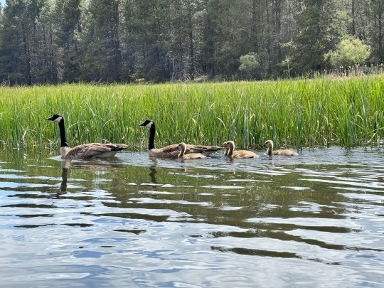
Thinking about this wonderful Canada goose family we saw on the Deschutes River last spring. There are still four or five months of winter until spring reaches central Oregon again.
In this stretch, the Deschutes River meanders lazily through verdant wetlands, the floor of an ancient lake. Many times in its life, the river has been dammed by lava flows from Newberry Volcano, Oregon’s largest active volcano. The river ponds behind the lava flows and builds up a large lake that can last for decades before it eventually erodes through (or around) the offending lavas and empties. The fertile lakebed soil historically made this high altitude plain a center of agriculture, but now it’s mostly vacation homes and lovely kayak routes through a -mostly- healthy ecosystem.
#oregon#photography#geology#pacific northwest#bettergeology#adventures#kayaking#goose#geese#baby geese#Deschutes River#Deschutes
7 notes
·
View notes
Text

Film panoramic camera shot (Horizon Kompakt) of the Strawberry Mountains from near where I dug my research trench last year. Last sunset of the field season.
#oregon#geology#photography#pacific northwest#bettergeology#35mm film#panorama#panoramic#landscape photography
7 notes
·
View notes
Note
What your Favorite thing which exists below sea level?
Good question! If we're talking about things on land below sea level, then it's Death Valley. The floor of Death Valley's salt pan is 282 (86 m) feet below sea level, the product of complex plate tectonics.
In the ocean, my favorite natural* feature has to be the Challenger Deep, the deepest point of the Marianas Trench over 35,800 feet (10,920 m) below the surface of the sea.
6 notes
·
View notes
Text

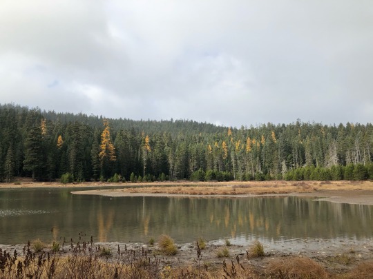


Studying and mapping the recently discovered Twin Lakes Fault on Mount Hood, Oregon. This segment bounds Frog Lake, and the lake is being dropped down while the mountain is being uplifted. This is called a normal fault. In most places, the scarp is about 1.5m high. The downed tree crosses the scarp.
#oregon#geology#adventurouswatermelon#adventures#pacific northwest#bettergeology#faulting#faults#earthquake#high cascades
87 notes
·
View notes
Last Seen Blogs

designtool5-blog
Design Tool 5

too-many-egos
an ego filled blog

archeoenlutte
Les archéologues enterrés

ruki-mukami-dl
𝐑𝐮𝐤𝐢 𝐌𝐮𝐤𝐚𝐦𝐢

james-errand
The Errand Observer