#archaeological excavations
Text
WOW.
Scientists found an amazingly well-preserved village from 3,000 years ago
Text below, in case article access dries up:
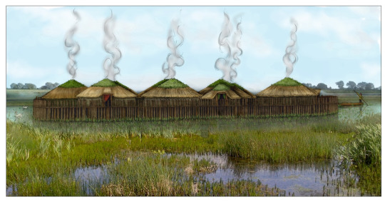
LONDON — A half-eaten bowl of porridge complete with wooden spoon, communal rubbish bins, and a decorative necklace made with amber and glass beads are just a handful of the extraordinarily well-preserved remnants of a late Bronze Age hamlet unearthed in eastern England that’s been dubbed “Britain’s Pompeii” and a “time capsule” into village life almost 3,000 years ago.
The findings from the site, excavated in 2015 to 2016, are now the subject of two reports, complete with previously unseen photos, published this week by University of Cambridge archaeologists, who said they cast light onto the “cosy domesticity” of ancient settlement life.
“It might be the best prehistoric settlement that we’ve found in Britain,” Mark Knight, the excavation director and a co-author of the reports, said in an interviewThursday. “We took the roofs off and inside was pretty much the contents,” he said. “It’s so comprehensive and so coherent.”
The reason for the rare preservation: disaster.
The settlement, thought to have originally consisted of several large roundhouses made of wood and constructed on stilts above a slow-moving river, was engulfed by a fire less than a year after being built.
During the blaze, the buildings and much of their contents collapsed into a muddy river below that “cushioned the scorched remains where they fell,” the university said of the findings. This combination of charring from the fire and waterlogging led to “exceptional preservation,” the researchers found.
“Because of the nature of the settlement, that it was burned down and its abandonment unplanned, everything was captured,” Knight added.
“As we excavated it, there was that feeling that we were picking over someone else’s tragedy,” he said of the eerie site in the swampy fenland of East Anglia. “I don’t think we could smell the fire but the amount of ash around us — it felt close.”
Researchers said they eventually unearthed four large wooden roundhouses and an entranceway structure, but the original settlement was probably “twice as big.”
The site at Must Farm dates to about 850 B.C., eight centuries before Romans came to Britain. Archaeologists have been shocked at “just how clear the picture is” of late Bronze Age life based on the level of detail uncovered, Knight said.
The findings also showed that the communities lived “a way of life that was more sophisticated than we could have imagined,” Duncan Wilson, head of Historic England, the public body responsible for preserving England’s historic environment, said in a statement.
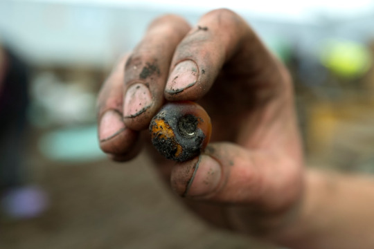
The findings unearthed include a stack of spears, possibly for hunting or defense; a decorative necklace “with beads from as far away as Denmark and Iran”; clothes of fine flax linen; and a female adult skull rendered smooth, “perhaps a memento of a lost loved one,” the research found.
The inhabitants’ diet was also rich and varied, including boar, pike and bream, along with wheat and barley.
A pottery bowl with the finger marks of its maker in the clay was also unearthed, researchers said, still containing its final meal — “a wheat-grain porridge mixed with animal fats” — with a wooden spatula resting inside the bowl.
“It appears the occupants saved their meat juices to use as toppings for porridge,” project archaeologist Chris Wakefield said in the university’s news release. “Chemical analyses of the bowls and jars showed traces of honey along with ruminant meats such as deer, suggesting these ingredients were combined to create a form of prehistoric honey-glazed venison,” he added.
Skulls of dogs — probably kept as pets and to help with hunting — were also uncovered, and the dogs’ fossilized feces showed they fed on scraps from their owners’ meals, the research found.
The buildings, some connected by walkways, may have had up to 60 people living there all together, Knight said, along with animals.
Although no intact sets of human remains were found at the site, indicating that the inhabitants probably fled the fire safely, several sheep bones were found burned indoors. “Skeletal remains showed the lambs were three to six months old, suggesting the settlement was destroyed sometime in late summer or early autumn,” according to the university’s news release.
Ceramic and wooden vessels including tiny cups, bowls and large storage jars were also found. Some pots were even designed to nest, stacked inside one another, Knight said — evidence of an interest in aesthetics as well as practicality.
A lot of similar items were found replicated in each home, Knight added, painting the picture of completely independent homesteads for each family unit rather than distinct buildings for shared tasks — much like we live today.
Household inventories often included metal tools, loom weights, sickles for crop harvesting, axes and even handheld razors for cutting hair.
The roundhouses — one of which had almost 50 square meters (nearly 540 square feet) of floor space — had hearths and insulated straw and clay roofs. Some featured activity zones for cooking, sleeping and working akin to modern-day rooms.
The Must Farm settlement has produced the largest collection of everyday Bronze Age artifacts ever discovered in the United Kingdom, according to Historic England, which partly funded the 1.1 million pound ($1.4 million) excavation project.
The public body labeled the site a “time capsule,” including almost 200 wooden artifacts, over 150 fiber and textile items, 128 pottery vessels and more than 90 pieces of metalwork. Some items will go on display at the nearby Peterborough Museum next month.
Archaeologists never found a “smoking gun” cause for the fire, Knight said. Instead, they suspect it was either an attack from “outside forces,” which may explain why the inhabitants never returned to collect their possessions from the debris, or an accidental blaze that spread rapidly across the tightly nestled homes.
“Probably all that was left was the people and what they were wearing; everything else was left behind,” Knight said of the fire.
But the preservation has left a window for people to look back through in the future. “You could almost see and smell their world,” he said.
“The only thing that was missing was the inhabitants,” Knight added. “And yet … I think they were there — you certainly got glimpses.”
2K notes
·
View notes
Text

Original excavations of Pompeii
181 notes
·
View notes
Text

Young Girl at the Excavations of Pompeii
by Filippo Palizzi
#filippo palizzi#art#excavation#excavations#excavating#history#antiquity#archaeology#europe#european#pompeii#italy#southern italy#girl#maiden#archaeologists#architecture#ancient rome#ancient roman#roman#ruins#fresco#frescoes#painting
854 notes
·
View notes
Link
KICKING OFF THE HALLOWEEN SEASON WITH A REAL BANG, POLAND
Although also very practical, sickle across the neck. Even if she does wake up, she’s not going anywhere...at least not very far...
668 notes
·
View notes
Photo
We began work on January 28, but the highlight of this week was the January 31 visit to the site by Anne Pasternak, the Brooklyn Museum Director, and members of the Museum’s Board of Governors. We were thrilled to be able to show them the site where Brooklyn has worked for the past 40+ years. We hope they enjoyed their visit.

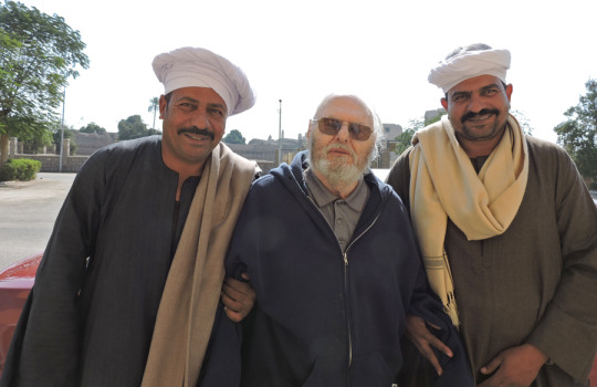
As promised last week, here are the members of our team. Our foreman again this year is Abdel Aziz Farouk Sharid (left). He and our inspector, Haitham Mohamed Sa’ad el-Din are discussing the season’s work. The Supreme Council of Antiquities (SCA) assigns an inspector to every expedition to act as liaison with the SCA and help facilitate the work. We are happy to have Haitham with us this season.

Besides Abdel Aziz, the Qufti who working with us this year are Abdel Aziz’s brother Ayman Farouk Sharid (center), the foreman for the Johns Hopkins University expedition who works with us when Hopkins isn’t in the field; and Mamdouh Kamil, who has worked with us for many seasons. All are from the village of Quft (ancient Coptos), which has a long tradition of archaeology going back to the late 19th century. Ayman and Abdel Aziz are the sons of one of the great Egyptian archaeologists, the late Farouk Sharid Mohamed, who was a beloved friend and treasured colleague. His sons are worthy successors to him.
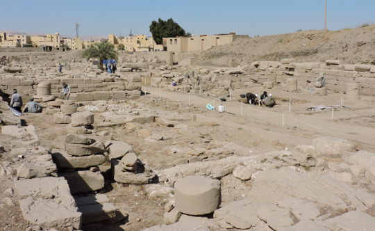
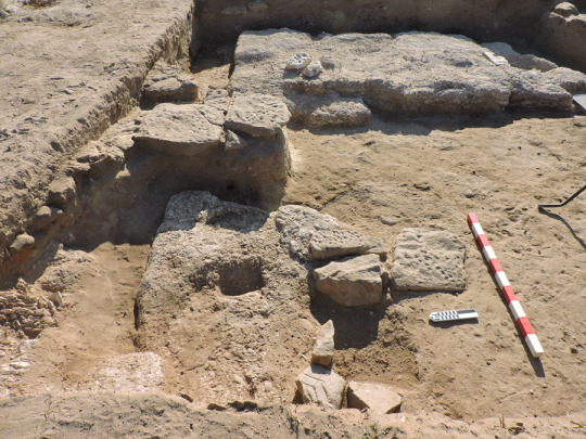
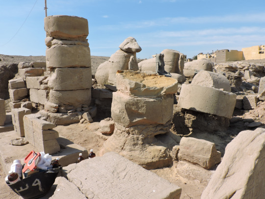
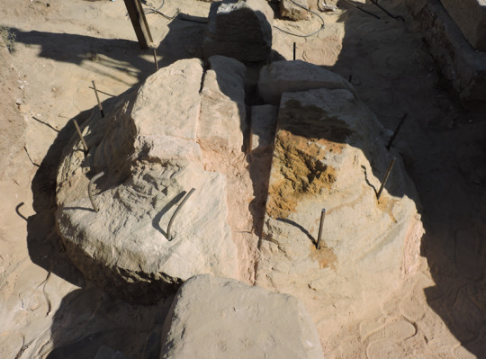
You are looking northwest at the first court of Temple A, which stands northeast of the Mut Temple. We are working in two areas of the court this year. In 2019 we were able to confirm that that the row of limestone features on the court’s south side were sphinx bases. This season we want to see if there are remains of corresponding bases on the north side (right). We are also clearing the corridor between the south colonnade and the south wall of the court (left).
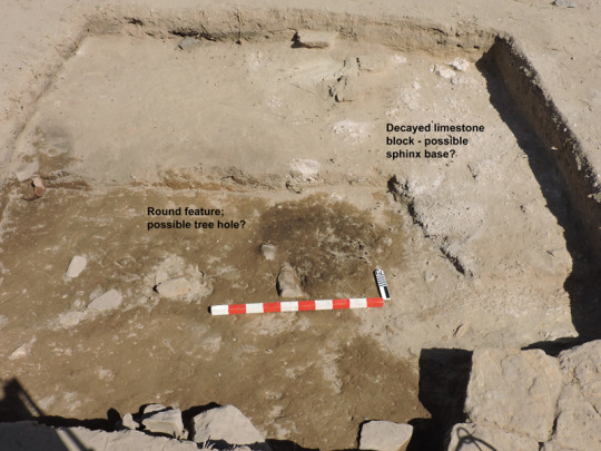
By the end of the week (February 2) the results in the north square were equivocal. Looking north, you can see an area of decayed limestone on the right side of the square that might be the remains of a sphinx base. On February 1, Mamdouh uncovered the round, dark feature to the left of the “sphinx base” that might be a tree hole. Sphinx avenues often had trees planted between the sculptures.

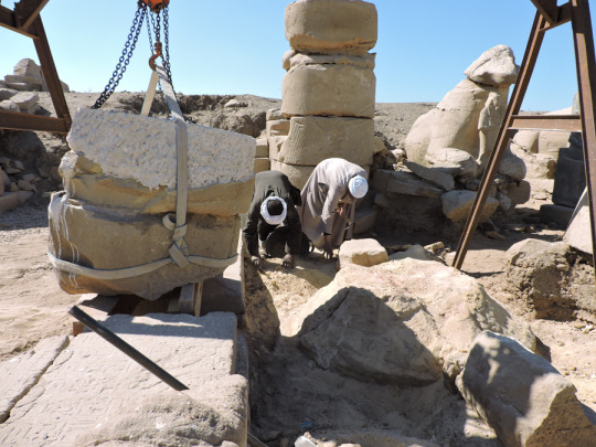
The work on the corridor was more productive. By the middle of the week Ayman had cleared a mass of broken stone and revealed the lowest course of the court’s south wall (left) and the footing of the temple’s 2nd Pylon. Both sit on a sand foundation that you can see below the blocks of stone. It was common to use sand in the foundations to level out uneven ground.
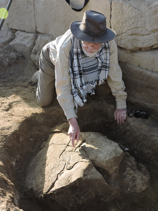
On February 1 our Dutch colleague, Jacobus (Jaap) van Dijk joined us for another season. First thing on the morning of February 2, Ayman called us over to show us an interesting find: a large relief-decorated block. Jaap immediately got down to have a look.

The block has a beautifully carved relief of Amun that clearly is Thutmoside in style, that is, from the reign of Hatshepsut and/or Thutmosis III, of the mid-15th century BC. What makes it particularly interesting is the small, shallowly carved graffito of a God’s Wife of Amun facing the Amun and dating stylistically to Dynasty 25 or 26, about 700 years after the god’s face was carved. God’s Wives of Amun were priestesses, usually the sisters or daughters of kings, who wielded great political power in the Third Intermediate Period and later.
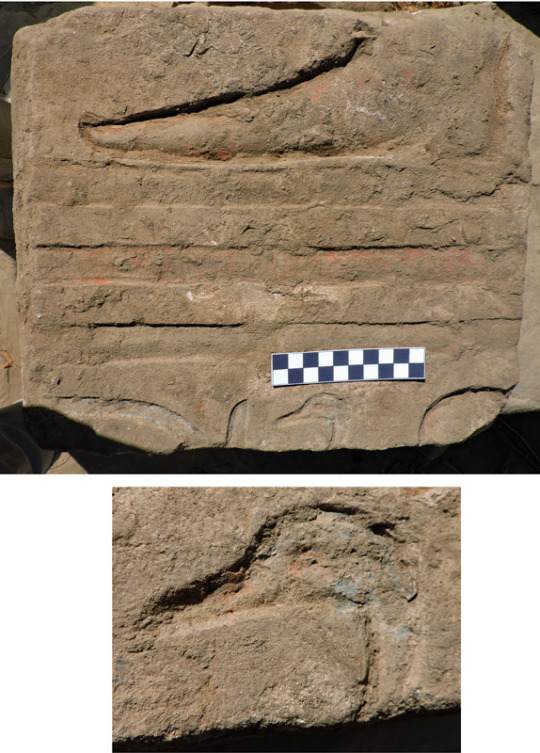
Just west of the Amun block was smaller cube of stone with a sunk relief depiction of a man’s foot on base lines with the top of a cartouche and the “son of Re” title below. The style of the foot (very long) and the vertical element of the cartouche date it to the reign of Akhenaten. It probably came originally from his temple in East Karnak, built before the king moved the capital to Amarna. The artist paid attention to detail when painting the relief, painting the head of the goose (“son”) blue but its beak and eye red. The Brooklyn Museum has an interesting group of Amarna Period reliefs showing a pastoral scene.
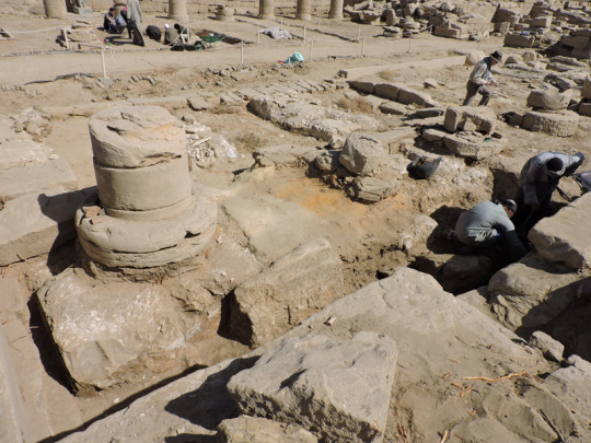
By the end of the week Ayman and his crew had cleared the bases of the first 3 columns of the colonnade, working from west to east. The blocks of the bases are large: 70 cm by 125 cm and almost 100 cm thick.
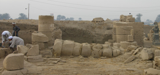
We are also planning on restoring 2 fallen columns in the colonnaded porches in front of the Mut Temple. The one in the East Porch is shown here as it was found in 1979. Work hasn’t started on these yet; there will be more about the restoration next week.
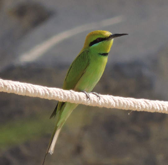
One of our favorite birds is the tiny, bright bee eater, so called because it catches insects in mid-air. This is the first we’ve seen this season.

An unusual cloud formation seen at sunset one night. Angels? Extraterrestrials?
Posted by Richard Fazzini and Mary McKercher
#BkMMutDig#MutDig#Mut#temple#Egypt#excavation#BkMEgyptianArt#egyptian art#egyptian#amarna period#Akhenaten#Thutmoside#archaeology#Brooklyn Museum#brooklyn#museum#art
223 notes
·
View notes
Text


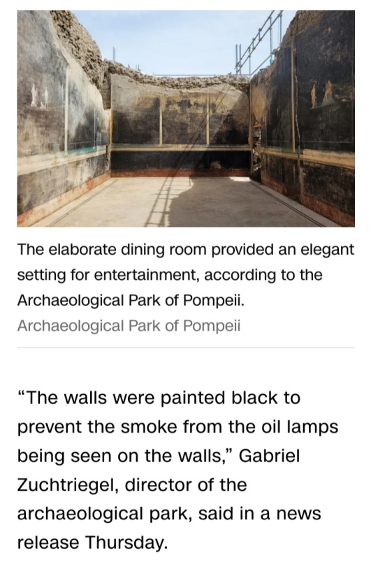
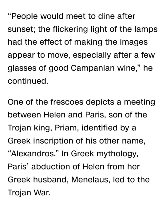

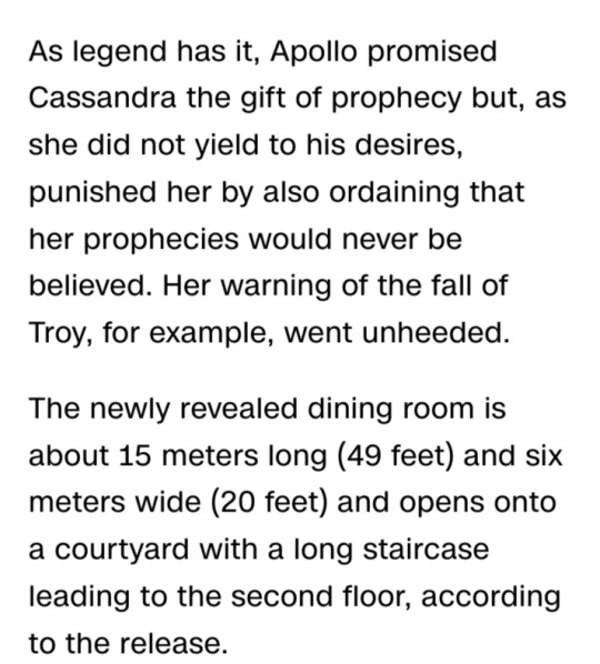


#Pompeii#Ancient Romans#frescoes#Apollo#Cassandra#King Priam of Troy#banquet halls#Archaeological Park of Pompeii#Helen#Paris#Menelaus#Trojan War#Mount Vesuvius#79 CE#excavation#archaeology
22 notes
·
View notes
Text

sing me silence, my soldier / sing us gently into death...
#em draws stuff#em is posting about sharpe#sharpe#daniel hagman#rifleman harris#once again I've drawn something where the pose is borrowed off archaeological excavation photos - this one is the lovers of modena#to make a long story short I got real sad and wanted to draw them a bit more of a goodbye. a quiet moment and a gift to see them off.#see the previous post in my sharpe-watching tag for a longer thought-scramble to go with this thing#reached the end of the drawing process and had to ask 'why does this feel familiar' before remembering the emotional experience I had#some years ago while reading 'the apparitionists' and also the formative time that was ken burns' the civil war... anyway. that aside.#this was going to be printed out for dorm decor but I think I could not look at this every day it would be far too much#I could have had my pick of appropriate folk songs for the caption lyrics but no this is a modified version of something from seawife#o'er the hills and o'er the main through flanders portugal and spain. y'know. y'know.
70 notes
·
View notes
Text
Dear early archaeologists,
Human remains are not your property. I am fully aware that the governments under which you attained the excavation material did not exercise their right to stop you from removing said remains.
However, any desecration of the individual’s remains, (such as some who have permanently arranged them in a manner for display like pouring resin over the remains, retained their bones for purposes other than scientific analysis, or any purposeful ignorance of the direct wishes of their modern ancestors) is proof of not only your unnecessary abandonment of the personhood of these ancient peoples, your disregard for those who are simply unlike you in any manner, and, finally, your carelessness for their culture in which you seem to have forgotten you have dedicated your time and likely quite a lot of your own money to.
Human remains as well as the material culture of these people is not yours to deserve, obtain, or hoard.
I understand that what you did was legal. In your eyes, it may have even been the most moral thing to do to preserve a person’s memory. However, there is no excuse to permit such irreversible behavior. Archaeology is a destructive science. You must understand that your worldview is not the collective goal of the world.
Remember the humanity of those from whom you seek to learn.
#dear early archaeologists#archaeology#history#writing letters#morality#letters to dead people#life as a modern archaeologist#we have to deal with this crap#excavation#ethics#respect the dead#human remains
130 notes
·
View notes
Photo


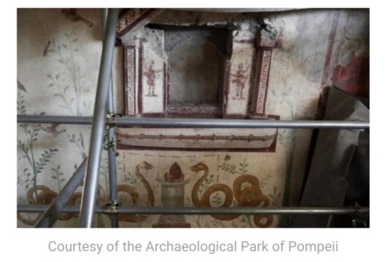
Excavations at Thera
The destruction of Pompeii by the volcano Vesuvius has become synonymous with the nature disaster of volcanic eruptions. The eruption of Vesuvius, among the deadliest in history, was the first natural disaster of its kind to have a first-handwritten account and this documented event has persisted in the public consciousness for nearly two millennia. Yet, despite being the one of the most famous and the deadliest, the eruption of Vesuvius is far from the most destructive. That honor might well go to the eruption of Thera in the 16th or 17th century BCE.
Excavations conducted on this Cycladic Island (among the Aegean Islands), such as the ones recorded in Excavations at Thera a seven-volume set of reports written by by the noted Greek archaeologist Spyridon Marinatos and published by Archaiologikē Hetaireia en Athēnais between 1967-1971, showed that during the Minoan period (2000-1200 BCE) Thera once held an integral port city. Remains showed that though the city was flourishing, its inhabitants abandoned the island for reasons that would soon become apparent to the excavators. It didn’t take long for archaeologists to discover that Thera once held an oval shape, differing greatly to the crescent it is today. Further inspection revealed that several ancient structures were far underwater, pointing to the island collapsing in on itself after their construction. It wasn’t long before the pieces were put together, leading to the discovery that Thera once held an active volcano that erupted in the Minoan period, destroying the island in its entirety.
The collapse of the Minoan civilization has been a mystery that persists to this day, yet finding this once active volcano led many to draw lines of connection between the two events. The reports written by Professor Marinatos reference this theory as near fact when describing the history of the ancient civilization. Such a theory does make a good amount of sense as this eruption would have been much greater than that of Vesuvius with estimated effects reaching all the way to China with reports of a series of harsh winters. Yet as excavations on both the Cycladic Islands and Crete continued, the date for the eruption got pushed back as the fall of the Minoan civilization crept forward. Currently the most accurate date for the eruption of Thera is 1628 BCE with some room for error while the fall of the Minoans sits between 1200-1100 BCE.
View more of my Classics posts.
– LauraJean, Special Collections Undergraduate Classics Intern
#Eruption of Thera#Thera#volcanoes#greek history#Minoan history#Cyclades#volcanic eruptions#Crete#Excavations at Thera#Spyridon Marinatos#archaeology#Greek archaeology#Archaiologikē Hetaireia en Athēnais#Archaeological Society at Athens#Classics#LauraJean
65 notes
·
View notes
Text
hey do you guys want to see another bollock dagger

why am I asking of course you do
#provenance: excavated in 1990 near the hoogstraat in rotterdam (netherlands)#it's 32.5cm long and dates to 1350-1550AD#description in alt text#bollock dagger#ballock knife#archaeology
149 notes
·
View notes
Text
youtube
Discover the wonder of the secrets of King Herod’s Temple from ancient carvings to beautiful gold from 2,000 years ago.
#WalktheBible#kingHerod#HerodsTemple#Temple#Carving#Jerusalem#TempleMount#DomeoftheRock#SecondTemple#FoundationStone#Israel#WellofSouls#ThirdTemple#visitisrael#jerusalemoftheday#jerusalemcity#Excavations#ArchaelogicalExcavations#AncientJerusalem#UnderJerusalem#UndergroundJerusalem#VisitJerusalem#WalkIsrael#WalkJerusalem#ChristianTravel#ChristianTraveller#Jesus#God#Archaeology#BiblicalArchaeology
7 notes
·
View notes
Photo

tools
#© victor s. brigola#brigola#tools#tool#digging tools#digging#excavation#archaeology#archaeological site#square#germany#stilllife#fuji x-pro 3
33 notes
·
View notes
Text
Archaeologists use a lot of different tools when excavating. These will differ depending on the geographical area you are working in, the site conditions, and the type of archaeology you are doing. [Read More]
#archaeologists#archaeology#fieldwork#archaeologist#archeology#crm#museum#artifacts#trowel#excavation#survey#safety
7 notes
·
View notes
Text

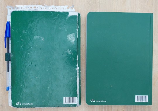
my 240 page archaeology notebook is full! carried it around with me & used it every single day for 9 months
to be loved is to be changed
#to be loved is to be changed#i had it with me on excavation in turkey and lost it twice but found it both times and got myself a second one just in case#it's a plain dotted dtv notebook special edition for piatti's 100th birthday idk if it's still available but yeah. did its job and more!!#didn't think it'd survive turkey tbh it already fell apart at the spine when i left for the airport but it did!! and served another 4 month#gremlin speaks#notebook#archaeology#writing
6 notes
·
View notes
Photo

Imagine waking up to this view every morning. This picture was taken at sunrise on February 15. The view of the Theban cliffs never gets old.
This is something of a bittersweet post. This is our last season in the field, which means we must say goodbye to Ayman and Abdel Aziz. We have known them since they were children and have worked with them as adults for many years. We treasure them and their friendship greatly and regret that we will likely never see them again. Partings are hard.

We had to cut this season short because of health problems, but we managed to accomplish what we set out to do. This photo from the precinct’s enclosure wall shows Temple A’s First Court with the north square with its sphinx bases in the foreground and the colonnade along the south side of the court in the rear
We now have not one but two sphinx bases. You are looking east across what is left of the second base in the northwest corner of the square. Only the northern part of the base remains; the rest is completely gone. The better-preserved base is in the background. The discovery of this second base is even more confirmation that there was once a row of sphinxes on the north side of the court as on the south.
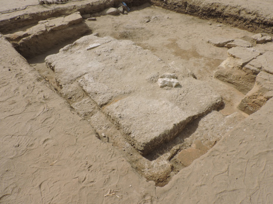
Something of a surprise was the discovery of part of the original paving along the north and east sides of the larger base. It took Mamdouh great patience and skill to bring this paving to light.

Ayman went as far as he could in the corridor on the south side of the court. In addition to the usual broken stone, it is clear that the south wall of the court collapsed at this point, with large blocks now completely blocking the corridor

This view of the corridor, looking east, was taken on February 14, our second last day at the site. The columns and their massive limestone and sandstone foundations are now clear, although we did not find any trace of the corridor’s original flooring, which had been removed in antiquity.
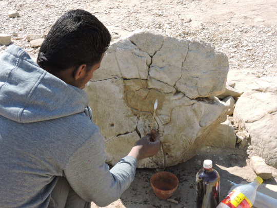
Unlike sandstone, which can decay into sand but is otherwise pretty stable, limestone has a tendency to fracture. When we removed the beautiful limestone block with the head of Amun and the God’s Wife of Amun, it broke to pieces. An Egyptian conservator is painstakingly putting it back together (the block is upside down). He hadn’t finished by the time we left, but Abdel Aziz has promised a photo of the finished restoration that we can show in the next post
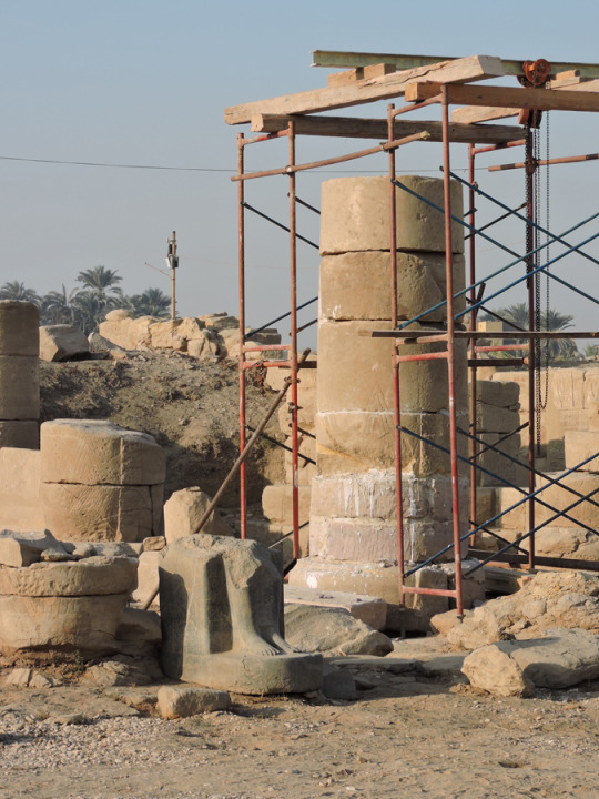
This is the east, better-preserved side of the column in the East Porch at the end of the season.

The other side of the column was much more damaged, so the restorers have been filling in the missing portions with a cement mixture. The man on the scaffold is roughing up the surface so that the finishing coat can be applied. Once that’s done, all the drips will be cleaned up.

The second column to be restored this season was found when we cleared the Mut Temple’s West Porch in 2005. We haven’t talked about it yet as it is a more complicated project that couldn’t begin until the repairs to the east column were well underway. As you can see, it, too, collapsed to the west, but what remained standing has been seriously damaged by flooding, which causes sandstone to decay. The top block has turned mostly to sand, and the column base is very decayed as well.
By the start of this season, little was left of the upper block, so the restorers’ first task was to clean up the base and remove the sand from the upper block so that what is left could be consolidated. This photo shows the state of the column on February 4.
The next step was to build a form to fill in the missing part of the upper block to a uniform height. Then both column drums were moved onto a temporary platform so the base could be cleaned. It, too, had largely turned to sand, so Mamdouh went to work to clear the sand down to solid stone.
This is the condition of the column base on February 15, our last day at the site. Interestingly it is made up of several small blocks rather than the usual pair of semi-circular blocks. The metal bars will reinforce the fill that will bring the base up to a proper level.
Work on both columns will go on after we have gone. When the repairs are complete, Abdel Aziz will send us photos that we will post to show the result of their efforts. The work is expected to take another 10 days, so there will be something of a gap between this post and the final one of the season.

On Sunday Mary spotted this painted lady butterfly near where we are working, the first we’ve ever seen at Mut. Only a few inches across, this small creature migrates across the Sahara Desert every year. Amazing! We thank our niece, naturalist Rosemary Mosco, for identifying it for us.
Posted by Richard Fazzini and Mary McKercher
#BkMMutDig#MutDig#Brooklyn Museum#art#excavation#Egypt#temple#BkMEgyptianArt#archaeology#brooklyn#museum#sahara desert#amun#column#limestone
88 notes
·
View notes
Text
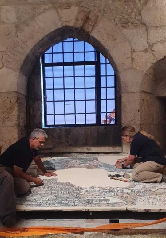
What did Jerusalem’s main road look like about 1,500 years ago?
An archaeological excavation conducted by the Israel Antiquities Authority in 2010 near the Old City’s Jaffa Gate brought to life a 1,500 year-old map.
The Madaba Map is an ancient mosaic map that paves the floor of Saint George’s Church in the city of Madaba, Jordan.
The map, created in 6th-7th centuries CE, depicts the Land of Israel during the Byzantine period.
It clearly shows the entrance into Jerusalem from the west via a central single gate that led to the main street of the city.
In the past, the reliability of the map, which, among other buildings, provides the earliest visual description of the Church of the Holy Sepulchre, has been questioned.
The excavation, located near David Street known to tourists as the terraced shopping street exposed for the first time, archaeological evidence of Jerusalem’s central street from about 1,500 years ago.
The salvage excavation, carried out in the wake of infrastructure works undertaken in the area and funded by the Jerusalem Development Authority, gave the archaeologists and the public a rare glimpse into archaeological remains underlying the asphalt and the paving stones.
Familiar with the Madaba Map, Dr. Ofer Sion, Director of the Excavation on behalf of the Israel Antiquities Authority, suspected that the ancient main street underlay the modern road.
"After removing a several archaeological layers, about 4.5m below modern street level, we were excited to discover the large stone slabs, each about one meter long, that were part of the ancient street.
It’s great to see that today’s bustling David Street preserves the route of the Byzantine-period busy street from 1,500 years ago.”
The Madaba Map, whose extant part measures 16x5m, depicts the land of Israel as known to the mosaic artist.
Map encompasses the entire country, with emphasis on Jerusalem and its Christian sites.
It shows that many churches were first constructed in Jerusalem during this period, when city underwent a religious transformation from a pagan to a Christian city.
The churches can be identified by their red tiled roofs illustrated on the map.
© Israel Antiquities Authority
#Madaba Map#Jerusalem#Israel Antiquities Authority#Old City#Jaffa Gate#archaeological excavation#archaeology#ancient mosaic map#mosaic map#Israel#Byzantine period#Saint George’s Church#Church of the Holy Sepulchre#Jerusalem Development Authority#ancient main street#streets#churches#maps#6th century#7th century
7 notes
·
View notes
Last Seen Blogs

idkokstop
livin
idkokstop
livin

17gz
𓆣

welcome-to-roomba-fazbender
50 YEARS still no kids dead

fricka
Got hit with bows and arrows oh