#Near Surface Geophysics
Text

Alcatraz Island still draws tourists for its history as a federal penitentiary. But it also has a rich past as little-known military base, erected to guard against foreign invasion. Image Credit: Mbprojekt Maciej Bledowski, iStock
Ground-Penetrating Radar Reveals Military Structures Buried Beneath Alcatraz Penitentiary
Using non-invasive techniques, archaeologists have confirmed the presence of a coastal fortification beneath what was once the prison’s recreation yard.
— By Katherine J. Wu, Published March 4, 2019 | August 02, 2023
Alcatraz might be best known as a popular tourist destination, the site of the former high-security prison that once held Al Capone. But a team of archaeologists has now unveiled new evidence of this San Francisco Bay island’s often overlooked military history.
In the study, published last Thursday in the journal Near Surface Geophysics, researchers used non-invasive technologies to pull back the curtain on a stunningly well-preserved 19th century coastal fortification that lies beneath the ruins of this infamous federal penitentiary. The work confirms that while prison construction in the early 1900s destroyed much of the former military installation, several structures were buried more or less intact, enshrining a critical sliver of Alcatraz’s colorful past.
“This really changes the picture of things,” says study author Timothy de Smet, an archaeologist at Binghamton University. “These remains are so well preserved, and so close to the surface. They weren’t erased from the island—they’re right beneath your feet.”
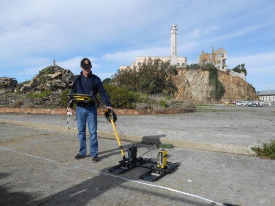
Study author Timothy de Smet used non-invasive techniques to create a subsurface map of remains of Alcatraz Island's former military fortification. Image Credit: Timothy de Smet, Binghampton University
Prior to the mid-1800s, Alcatraz Island was a barren strip of land capable of supporting little more than a raucous population of seabirds. But in the wake of the California Gold Rush, the United States government looked to the rocky outcrop as a potential military base to protect the newly bustling city from foreign invasion. Over the next several decades, a stone- and brick-based fortification was erected, then rebuilt as earthen structures better equipped to handle erosion. But Alcatraz struggled to keep pace with the rapid changes in artillery during and after the Civil War era, and by the late 1800s, the island’s defenses were essentially obsolete. Military pursuits on Alcatraz were abandoned shortly thereafter.
When the island’s prison was erected around the turn of the 20th century, little physical evidence of its former architecture remained—or so many thought. The new study, led by de Smet, says otherwise. To look beneath the surface, the researchers deployed ground-penetrating radar, which pulses electromagnetic waves into the earth, returning signals that can visualize remains without excavation. The strategy uncovered a labyrinth of subterranean structures, including an earthwork traverse, a kind of defensive trench, running beneath the penitentiary’s former recreation yard.
“Below the Surface, Alcatraz is Still Full of Mysteries”
“This really reinforces what several historians and archaeologists had long suspected,” says study author and Alcatraz historian John Martini. “Up until this point, we had nothing to go on except for a few visible trace remains and maps—and a lot of suspicion.”
In a way, Martini says, the findings reflect just how limited real estate was on Alcatraz, which clocks in at less than 50 acres. “On a small island, there’s only so many places you can build,” he says. “And it’s unlikely they went to the trouble of demolishing all this stuff.”

A 15-inch Rodman cannon and its gun crew, 1869. These were the largest guns mounted on Alcatraz. Image Credit: National Park Service, Golden Gate National Recreation Area
Because they’re both sensitive and non-destructive, techniques like ground-penetrating radar are crucial for these kinds of investigations, and can complement historical records that survived the era, says Jolene Babyak, an Alcatraz historian who was not involved in the study.
With these results in hand, de Smet and his colleagues plan to continue archaeological investigations under Alcatraz. Going forward, only time will tell what this rock will reveal, Martini says. “Below the surface, Alcatraz is still full of mysteries,” he says. “There’s still a whole lot to be learned.”

Soldiers posing in the island’s ordnance yard. A brick Citadel capped the summit of Alcatraz. 1869. Image Credit: National Park Service, Golden Gate National Recreation Area
#NOVA | PBS#Ground-Penetrating Radar#Military Structures#Alcatraz Penitentiary#Non-invasive Techniques#Archaeologists#Coastal Fortification#Tourist Destination#High-Security Prison#Al Capone#San Francisco Bay#Military History#Near Surface Geophysics#Timothy de Smet#Binghamton University#California Gold Rush#Civil War Era
3 notes
·
View notes
Text
youtube
youtube
NASA’s Juno Gives Aerial Views of Mountain, Lava Lake on Io
Scientists on NASA’s Juno mission to Jupiter have transformed data collected during two recent flybys of Io into animations that highlight two of the Jovian moon’s most dramatic features: a mountain and an almost glass-smooth lake of cooling lava. Other recent science results from the solar-powered spacecraft include updates on Jupiter’s polar cyclones and water abundance.
The new findings were announced Wednesday, April 16, by Juno’s principal investigator Scott Bolton during a news conference at the European Geophysical Union General Assembly in Vienna.
Juno made extremely close flybys of Io in December 2023 and February 2024, getting within about 930 miles (1,500 kilometers) of the surface, obtaining the first close-up images of the moon’s northern latitudes.
“Io is simply littered with volcanoes, and we caught a few of them in action,” said Bolton. “We also got some great close-ups and other data on a 200-kilometer-long (127-mile-long) lava lake called Loki Patera. There is amazing detail showing these crazy islands embedded in the middle of a potentially magma lake rimmed with hot lava. The specular reflection our instruments recorded of the lake suggests parts of Io’s surface are as smooth as glass, reminiscent of volcanically created obsidian glass on Earth.”
Maps generated with data collected by Juno’s Microwave Radiometer (MWR) instrument reveal Io not only has a surface that is relatively smooth compared to Jupiter’s other Galilean moons, but also has poles that are colder than middle latitudes.
Pole Position
During Juno’s extended mission, the spacecraft flies closer to the north pole of Jupiter with each pass. This changing orientation allows the MWR instrument to improve its resolution of Jupiter’s northern polar cyclones. The data allows multiwavelength comparisons of the poles, revealing that not all polar cyclones are created equal.
“Perhaps most striking example of this disparity can be found with the central cyclone at Jupiter’s north pole,” said Steve Levin, Juno’s project scientist at NASA’s Jet Propulsion Laboratory in Southern California. “It is clearly visible in both infrared and visible light images, but its microwave signature is nowhere near as strong as other nearby storms. This tells us that its subsurface structure must be very different from these other cyclones. The MWR team continues to collect more and better microwave data with every orbit, so we anticipate developing a more detailed 3D map of these intriguing polar storms.”
Jovian Water
One of the mission’s primary science goals is to collect data that could help scientists better understand Jupiter’s water abundance. To do this, the Juno science team isn’t hunting for liquid water. Instead, they are looking to quantify the presence of oxygen and hydrogen molecules (the molecules that make up water) in Jupiter’s atmosphere. An accurate estimate is critical to piecing together the puzzle of our solar system’s formation.
Jupiter was likely the first planet to form, and it contains most of the gas and dust that wasn’t incorporated into the Sun. Water abundance also has important implications for the gas giant’s meteorology (including how wind currents flow on Jupiter) and internal structure.
In 1995, NASA’s Galileo probe provided an early dataset on Jupiter’s water abundance during the spacecraft’s 57-minute descent into the Jovian atmosphere. But the data created more questions than answers, indicating the gas giant’s atmosphere was unexpectedly hot and — contrary to what computer models had indicated — bereft of water.
“The probe did amazing science, but its data was so far afield from our models of Jupiter’s water abundance that we considered whether the location it sampled could be an outlier. But before Juno, we couldn’t confirm,” said Bolton. “Now, with recent results made with MWR data, we have nailed down that the water abundance near Jupiter’s equator is roughly three to four times the solar abundance when compared to hydrogen. This definitively demonstrates that the Galileo probe’s entry site was an anomalously dry, desert-like region.”
The results support the belief that the during formation of our solar system, water-ice material may have been the source of the heavy element enrichment (chemical elements heavier than hydrogen and helium that were accreted by Jupiter) during the gas giant’s formation and/or evolution. The formation of Jupiter remains puzzling, because Juno results on the core of the gas giant suggest a very low water abundance — a mystery that scientists are still trying to sort out.
Data during the remainder of Juno’s extended mission may help, both by enabling scientists to compare Jupiter’s water abundance near the polar regions to the equatorial region and by shedding additional light on the structure of the planet’s dilute core.
During Juno’s most recent flyby of Io, on April 9, the spacecraft came within about 10,250 miles (16,500 kilometers) of the moon’s surface. It will execute its 61st flyby of Jupiter on May 12.
More About the Mission
NASA’s Jet Propulsion Laboratory, a division of Caltech in Pasadena, California, manages the Juno mission for the principal investigator, Scott Bolton, of the Southwest Research Institute in San Antonio. Juno is part of NASA’s New Frontiers Program, which is managed at NASA’s Marshall Space Flight Center in Huntsville, Alabama, for the agency’s Science Mission Directorate in Washington. The Italian Space Agency (ASI) funded the Jovian InfraRed Auroral Mapper. Lockheed Martin Space in Denver built and operates the spacecraft.
5 notes
·
View notes
Link
5 Min Read Why is Methane Seeping on Mars? NASA Scientists Have New Ideas Filled with briny lakes, the Quisquiro salt flat in South America’s Altiplano region represents the kind of landscape that scientists think may have existed in Gale Crater on Mars, which NASA’s Curiosity Rover is exploring. Credits: Maksym Bocharov The most surprising revelation from NASA’s Curiosity Mars Rover — that methane is seeping from the surface of Gale Crater — has scientists scratching their heads. Living creatures produce most of the methane on Earth. But scientists haven’t found convincing signs of current or ancient life on Mars, and thus didn’t expect to find methane there. Yet, the portable chemistry lab aboard Curiosity, known as SAM, or Sample Analysis at Mars, has continually sniffed out traces of the gas near the surface of Gale Crater, the only place on the surface of Mars where methane has been detected thus far. Its likely source, scientists assume, are geological mechanisms that involve water and rocks deep underground. If that were the whole story, things would be easy. However, SAM has found that methane behaves in unexpected ways in Gale Crater. It appears at night and disappears during the day. It fluctuates seasonally, and sometimes spikes to levels 40 times higher than usual. Surprisingly, the methane also isn’t accumulating in the atmosphere: ESA’s (the European Space Agency) ExoMars Trace Gas Orbiter, sent to Mars specifically to study the gas in the atmosphere, has detected no methane. Why do some science instruments detect methane on the Red Planet while others don’t? “It’s a story with a lot of plot twists,” said Ashwin Vasavada, Curiosity’s project scientist at NASA’s Jet Propulsion Laboratory in Southern California, which leads Curiosity’s mission. Methane keeps Mars scientists busy with lab work and computer modeling projects that aim to explain why the gas behaves strangely and is detected only in Gale Crater. A NASA research group recently shared an interesting proposal. Reporting in a March paper in the Journal of Geophysical Research: Planets, the group suggested that methane — no matter how it’s produced — could be sealed under solidified salt that might form in Martian regolith, which is “soil” made of broken rock and dust. When temperature rises during warmer seasons or times of day, weakening the seal, the methane could seep out. Led by Alexander Pavlov, a planetary scientist at NASA’s Goddard Space Flight Center in Greenbelt, Maryland, the researchers suggest the gas also can erupt in puffs when seals crack under the pressure of, say, a rover the size of a small SUV driving over it. The team’s hypothesis may help explain why methane is detected only in Gale Crater, Pavlov said, given that’s it’s one of two places on Mars where a robot is roving and drilling the surface. (The other is Jezero Crater, where NASA’s Perseverance rover is working, though that rover doesn’t have a methane-detecting instrument.) Pavlov traces the origin of this hypothesis to an unrelated experiment he led in 2017, which involved growing microorganisms in a simulated Martian permafrost (frozen soil) infused with salt, as much of Martian permafrost is. Pavlov and his colleagues tested whether bacteria known as halophiles, which live in saltwater lakes and other salt-rich environments on Earth, could thrive in similar conditions on Mars. The microbe-growing results proved inconclusive, he said, but the researchers noticed something unexpected: The top layer of soil formed a salt crust as salty ice sublimated, turning from a solid to a gas and leaving the salt behind. Permafrost on Mars and Earth “We didn’t think much of it at the moment,” Pavlov said, but he remembered the soil crust in 2019, when SAM’s tunable laser spectrometer detected a methane burst no one could explain. “That’s when it clicked in my mind,” Pavlov said. And that’s when he and a team began testing the conditions that could form and crack hardened salt seals. Pavlov’s team tested five samples of permafrost infused with varying concentrations of a salt called perchlorate that’s widespread on Mars. (There’s likely no permafrost in Gale Crater today, but the seals could have formed long ago when Gale was colder and icier.) The scientists exposed each sample to different temperatures and air pressure inside a Mars simulation chamber at NASA Goddard. Periodically, Pavlov’s team injected neon, a methane analog, underneath the soil sample and measured the gas pressure below and above it. Higher pressure beneath the sample implied the gas was trapped. Ultimately, a seal formed under Mars-like conditions within three to 13 days only in samples with 5% to 10% perchlorate concentration. This is a sample of mock Martian regolith, which is “soil” made of broken rock and dust. It’s one of five samples that scientists infused with varying concentrations of a salt called perchlorate that’s widespread on Mars. They exposed each sample to Mars-like conditions in the Mars simulation chamber at NASA’s Goddard Space Flight Center in Greenbelt, Maryland. The brittle clumps in the sample above show that a seal of salt did not form in this sample because the concentration of salt was too low. NASA/Alexander Pavlov This image is of another sample of mock Martian “soil” after it was removed from the Mars simulation chamber. The surface is sealed with a solid crust of salt. Alexander Pavlov and his team found that a seal formed after a sample spent three to 13 days under Mars-like conditions, and only if it had 5% to 10% perchlorate salt concentration. The color is lighter in the center where the sample was scratched with a metal pick. The light color indicates a drier soil underneath the top layer, which absorbed moisture from the air as soon as the sample was removed from the simulation chamber, turning brown. NASA/Alexander Pavlov That’s a much higher salt concentration than Curiosity has measured in Gale Crater. But regolith there is rich in a different type of salt minerals called sulfates, which Pavlov’s team wants to test next to see if they can also form seals. Curiosity rover has arrived at a region believed to have formed as Mars’ climate was drying. Improving our understanding of methane generation and destruction processes on Mars is a key recommendation from the 2022 NASA Planetary Mission Senior Review, and theoretical work like Pavlov’s is critical to this effort. However, scientists say they also need more consistent methane measurements. SAM sniffs for methane only several times a year because it is otherwise busy doing its primary job of drilling samples from the surface and analyzing their chemical makeup. In 2018, NASA announced that the Sample Analysis at Mars chemistry lab aboard the Curiosity Rover discovered ancient organic molecules that had been preserved in rocks for billions of years. Findings like this one help scientists understand the habitability of early Mars and pave the way for future missions to the Red Planet.Credit: NASA’s Goddard Space Flight CenterDownload this video in HD formats from NASA Goddard’s Scientific Visualization Studio “Methane experiments are resource intensive, so we have to be very strategic when we decide to do them,” said Goddard’s Charles Malespin, principal investigator for SAM. Yet, to test how often methane levels spike, for instance, would require a new generation of surface instruments that measure methane continuously from many locations across Mars, scientists say. “Some of the methane work will have to be left to future surface spacecraft that are more focused on answering these specific questions,” Vasavada said. By Lonnie ShekhtmanNASA’s Goddard Space Flight Center, Greenbelt, Md. Share Details Last Updated Apr 22, 2024 Contact Lonnie Shekhtman [email protected] Location Goddard Space Flight Center Related Terms Curiosity (Rover) Goddard Space Flight Center Mars Mars Exploration Program Mars Science Laboratory (MSL) Missions NASA Directorates Planetary Science Division Science Mission Directorate The Solar System
2 notes
·
View notes
Text
The rocks are located near an area named Reiner Gamma, the small group of meter-sized rocks stood out because they are covered in a layer of dust with special reflective properties.
This will help us understand how moon dust moves and about magnetic properties on the moon.
Discovery of a Dust Sorting Process on Boulders Near the Reiner Gamma Swirl on the Moon
Journal of Geophysical Research: PlanetsVolume 129, Issue 1 e2023JE007910 Research Article
https://agupubs.onlinelibrary.wiley.com/doi/10.1029/2023JE007910
From a database of lunar fractured boulders
After a photo-geologic investigation and determined that the features correspond to a dust mantling on top of boulders with a unique photometric behavior.
2 notes
·
View notes
Text
NASA Goddard to Build Quake Detector for Artemis III Moon Landing - NASA
New Post has been published on https://sunalei.org/news/nasa-goddard-to-build-quake-detector-for-artemis-iii-moon-landing-nasa/
NASA Goddard to Build Quake Detector for Artemis III Moon Landing - NASA
NASA’s Goddard Space Flight Center in Greenbelt, Maryland, will build a moonquake detector for astronauts to deploy on the Moon in 2026 during the Artemis III mission, which will return astronauts to the lunar surface for the first time in more than 50 years.
NASA selected the instrument, the Lunar Environment Monitoring Station (LEMS) as one of the first three potential payloads for Artemis III. LEMS is a compact, autonomous seismometer designed to carry out continuous, long-term monitoring of ground motion from moonquakes in the region around the lunar South Pole. The data LEMS gathers will help scientists study the Moon’s internal structure and could help refine our understanding of how the Moon formed.
Planetary scientist Mehdi Benna, of the University of Maryland Baltimore County (UMBC) Center for Space Sciences Technology (CSST), leads the LEMS team at NASA Goddard.
“The LEMS project is the culmination of several years of collaboration between UMBC, University of Maryland, College Park, and NASA Goddard,” Benna said.
Benna began conceptualizing the idea behind the LEMS instrument in 2018 after realizing the need for technology that could withstand the Moon’s harsh conditions to measure lunar geophysical activity for a long duration of time.
The team began developing his idea of a small, self-sustaining station that operates almost like a buoy in the ocean — what Benna calls a “lunar buoy” — that can survive on the surface through the lunar night and operate during the day. In 2018, Benna’s team received funding from NASA’s Development and Advancement of Lunar Instrumentation program to develop LEMS to flight readiness.
LEMS is intended to operate on the lunar surface from three months up to two years and could become a key station in a future global lunar geophysical network.
Moonquakes were first observed after Apollo astronauts placed seismometers on the lunar surface during their missions between 1969 and 1972. Moonquakes’ sources include the same tug of gravity between Earth and the Moon that cause ocean tides. In addition, the Moon trembles as it expands and contracts due to temperature changes, like a house creaking when the weather heats up or cools down.
The Apollo seismic data was collected on the Earth-facing side of the Moon near the lunar equator. “We don’t have seismic data from the lunar South Pole that can inform us on the local and global lunar subsurface structure,” said Naoma McCall, LEMS co-investigator and seismologist at NASA Goddard.
UMBC leads LEM’s science investigation. NASA Goddard will build and operate LEMS. The University of Arizona will supply LEMS’ two state-of-the-art seismometer sensors; Morehead State University in Kentucky will provide LEMS’ telecommunication system and the homebase of the mission’s operation center, and Washington University in St. Louis, Missouri, will manage the instrument’s data processing and dissemination to the larger scientific community.
The other candidate instruments selected alongside LEMS are the Lunar Effects on Agricultural Flora instrument, led by researchers at Space Lab Technologies in Boulder, Colorado, and the Lunar Dielectric Analyzer instrument, led by researchers at the University of Tokyo and supported by JAXA (Japan Aerospace Exploration Agency).
Together these instruments could collect valuable scientific data about the lunar environment, the lunar interior and how to sustain a long-duration human presence on the Moon, helping prepare NASA to send astronauts to Mars. Final manifesting decisions for Artemis III will be made at a later date.
By Adriana Fraser,
University of Maryland, Baltimore County
Edited by Rani Gran,
NASA’s Goddard Space Flight Center, Greenbelt, Md.
0 notes
Text
Alaska Volcano Observatory
February 27 at 2:22 PM ·
Volcano: #Kanaga (VNUM #311110)
Current Volcano Alert Level: NORMAL
Previous Volcano Alert Level: ADVISORY
Current Aviation Color Code: GREEN
Previous Aviation Color Code: YELLOW
Issued: Tuesday, February 27, 2024, 11:10 AM AKST
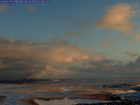
Volcanic unrest at Kanaga Volcano has subsided over the past several weeks and the Aviation Color Code is being decreased to GREEN and the Volcano Alert Level to NORMAL. Seismicity, which was elevated following a small explosion and ground-cracking event on December 18, 2023, has decreased to background levels. Satellite data show that there have been no recent surface changes, elevated temperatures, or gas emissions. When atmospheric conditions are favorable, web camera and satellite data show intermittent steaming from the crack near the summit crater.
Image: Webcam still from Kanaga cam KIMD, taken on February 26 at 9:07 AM local time (10:07 AM AKST). This image shows a sunrise shot of snow-covered Kanaga Volcano in the background, mostly visible amid some low clouds. The foreground is much more flat and dusted with snow between patches of brown winter grass. A small portion of ocean is visible on the left-hand side of the image.
#Alaska #volcano
USGS Volcanoes @usgsvolcanoes UAF Geophysical Institute @uaf.gi Alaska DGGS
See less
0 notes
Text
NASA’s flagship Artemis program aims to return humans to the lunar surface and to ultimately build a permanent lunar outpost. The first crewed missions of the program, Artemis 2 and 3, were recently delayed by nearly one year in order to address technical challenges impinging upon crew safety. Artemis 3 might slip further due to the long development roadmap for the Starship lunar lander. However, these setbacks have not diminished NASA’s ambitions for the long-term future of its lunar program. A recent paper by three aerospace engineers provides the first details on the interior of the Foundation Surface Habitat, which will become humanity’s first permanent home on the Moon.
The ultimate goal of the Artemis program is to establish a research outpost on the lunar surface. This facility, known as the Artemis Base Camp (ABC), will be situated near the lunar south pole in order to access deposits of water ice in permanently-shadowed craters. It will feature pressurized and unpressurized rovers, nuclear power systems, cargo landers for logistics, and instruments for geophysics and astronomy. The keystone of the base camp will be a large Foundation Surface Habitat (FSH). Astronauts will inhabit the habitat for a month or more at a time. Two of the four crewmembers will venture into the lunar outback to collect samples in a pressurized rover. Meanwhile, their colleagues will study the samples which they collect inside the habitat.
0 notes
Text
A New Way to Characterize Habitable Planets - Technology Org
New Post has been published on https://thedigitalinsider.com/a-new-way-to-characterize-habitable-planets-technology-org/
A New Way to Characterize Habitable Planets - Technology Org
For decades, science fiction authors have imagined scenarios in which life thrives on the harsh surfaces of Mars or our Moon, or in the oceans below the icy surfaces of Saturn’s moon Enceladus and Jupiter’s moon Europa. But the study of habitability—the conditions required to support and sustain life—is not just confined to the pages of fiction.
As more planetary bodies in our solar system and beyond are investigated for their potential to host conditions favorable to life, researchers are debating how to characterize habitability.
Dramatic plumes spray water ice and vapor from many locations along the famed “tiger stripes” near the south pole of Saturn’s moon Enceladus. The tiger stripes are four prominent, approximately 84-mile- (135-kilometer-) long fractures that cross the moon’s south polar terrain.
Image credit: NASA/JPL-Caltech/Space Science Institute
While many studies have focused on the information obtained by orbiting spacecraft or telescopes that provide snapshot views of ocean worlds and exoplanets, a new paper emphasizes the importance of investigating complex geophysical factors that can be used to predict the long-term maintenance of life. These factors include how energy and nutrients flow throughout the planet.
“Time is a crucial factor in characterizing habitability,” says Mark Simons, John W. and Herberta M. Miles Professor of Geophysics at Caltech. “You need time for evolution to happen. To be habitable for a millisecond or a year is not enough. But if habitable conditions are sustained for a million years, or a billion…? Understanding a planet’s habitability takes a nuanced perspective that requires astrobiologists and geophysicists to talk to each other.”
This perspective paper, which appears in the journal Nature Astronomy, is a collaboration between Caltech scientists on the Pasadena campus and at JPL, which Caltech manages for NASA, along with colleagues representing a variety of fields.
The study emphasizes new directions for future missions to measure habitability on other worlds, using Saturn’s icy moon Enceladus as a primary example. Enceladus is covered in ice with a salty ocean beneath. In the last decade, NASA’s Cassini mission acquired chemical measurements of plumes of water vapor and ice grains jetting out from fissures at Enceladus’s south pole, discovering the presence of elements like carbon and nitrogen that could be conducive to life as we know it.
These geochemical properties are sufficient to describe the moon’s “instantaneous” habitability. However, to truly characterize Enceladus’s long-term habitability, the paper emphasizes that future planetary missions must study geophysical properties that indicate how long the ocean has been there, and how heat and nutrients flow between the core, the interior ocean, and the surface. These processes create important geophysical signatures that can be observed, as they affect features such as the topography and thickness of Enceladus’s ice crust.
This larger framework for studying habitability is not limited to the study of Enceladus. It applies to all planets and moons where researchers search for the conditions necessary for life.
“This paper is about the importance of including geophysical capabilities in future missions to the ocean worlds, as currently being planned for the Europa Clipper mission targeting Jupiter’s moon Europa,” says Steven Vance, a JPL scientist and deputy manager for the Lab’s planetary science section, as well as a co-author of the paper.
Written by Lori Dajose
Source: Caltech
You can offer your link to a page which is relevant to the topic of this post.
#Astronomy#Astronomy news#billion#caltech#carbon#chemical#Collaboration#crust#Enceladus (Saturn's moon)#energy#Europa#Evolution#Exoplanets#extraterrestrial life#factor#Features#framework#Future#geophysics#habitable planets#Heat#how#how to#it#JPL#Jupiter#life#Link#mars#measure
0 notes
Text
EARTH SCIENCE
STRATIGRAPHY: How layering of rocks and strata are analyzed to measure geologic time.
PALEONTOLOGY: How organisms evolve and their interaction with the environment by studying fossil records often found in rocks.
MICROPALEONTOLOGY: How microfossils are characterized. Paleo is short for “paleolithic” which often refers to the geologic past.
PALEOMAGNETISM: How to reconstruct previous magnetic fields in rocks including the direction and intensity to explore pole reversals in different time periods.
GEOMORPHOLOGY: How landforms, physical features and geological structures on Earth were created and evolved.
PALEOSEISMOLOGY: The scientific study of prehistoric earthquakes and seismic activity by examining geological evidence, such as fault lines and sediment layers, to understand the history of seismic events in a region.
MAGNETOSTRATIGRAPHY: How sedimentary and volcanic sequences are dated by geophysically correlating samples of strata deposited with the Earth’s magnetic field polarity. In a nutshell, this is the field of study that studies magnetic fields in rocks and past pole reversals.
GEOCHRONOLOGY: How old rocks and geological events are dated using signatures inherent in rocks. Studying layers of rock as they relate to geologic time.
TECTONICS: How Earth’s crust evolves through time contributing to mountain building, old core continents, and earthquakes/volcanoes. This field applies the underlying principles of plate tectonics to seismology, volcanoes, earthquakes, and other geological events.
VOLCANOLOGY: How and where volcanoes and related phenomena erupt and form. As tectonics plays a key role in volcanoes, volcanology describes the types of volcanoes on Earth and their associated risk of impacting the biosphere.
SEISMOLOGY: How seismic waves travel through and around the Earth from earthquakes. We use seismic tomography from earthquakes to see inside our planet and create 3D models of the surrounding layers of Earth’s core.
NEOTECTONICS: The study of recent geological processes and their impact on the Earth’s crust, focusing on the deformation and movements occurring in the Earth’s surface in the present and near past.
TECTONOPHYSICS: How the Earth’s crust and mantle deform specific to its physical processes. Moreover, this field does target the physical process that acts on the behavior of waves.
SEISMOTECTONICS: How earthquakes, active tectonics, and individual faults are related to seismic activity.
PETROLOGY: How types of rocks (igneous, metamorphic, and sedimentary petrology) form in their specific environment. For example, petrology uses mineralogy and rock types to understand geological formations from drilling. In addition, they study the chemical properties and how atoms are arranged.
GEOLOGY: The study and science of how Earth’s landforms were created, have changed over time and how they will evolve.
■MINERALOGY: The
branch of geology that
focuses on the study of
minerals, their
composition, structure,
properties, and distribution
in nature.
GEMOLOGY: How natural and artificial gems are identified and evaluated, encompassing their identification, evaluation, and understanding of their properties and origins.
CRYSTALLOGRAPHY: The scientific study of crystals, focusing on the arrangement of atoms within crystalline solids and their geometric properties, aiding in the understanding of material structures and properties.
SOIL SCIENCES: How soil relate as a natural resource including their formation factors, classification, physical, chemical, and fertility properties. Engineering fields consider soil as regolith. But for agriculture production, soil is considered a natural resource.
■PEDOLOGY: The
scientific study of soils,
encompassing their
formation, classification,
distribution, and how they
interact with the
surrounding environment.
■EDAPHOLOGY: The
branch of soil science that
examines the influence of
soils on plants, their
growth, and the
surrounding ecosystem,
encompassing the study of
soil properties, fertility, and
their impact on agriculture
and ecology.
AGRONOMY: How the field of agriculture involves science such as crop production, biotechnology, and soil science.
HYDROGEOLOGY: How groundwater is transported and distributed in the soil, rock, and Earth’s crust. Hydrogeology specializes in anything from surface-groundwater interactions, the direction of flow for groundwater, and measuring depths to the water table.
POMOLOGY: How fruits and nuts grow. And how they are cultivated. Pomology is loosely tied to horticulture, agronomy, and agrology with a focus on producing successful crops.
SEDIMENTOLOGY: How sand, silt, and clay are deposited and the processes that act on them. By understanding erosion, movement, and deposition of sediments, sedimentologists support the search for oil reserves and contaminated sites in mining, petroleum, and research.
SURFICIAL GEOLOGY: How surface sediment (till, gravel, sand, clay, etc.) overlying bedrock was formed such as during glacial retreat or in lakes associated with these periods.
GLACIOLOGY: How ice and glacial deposits have reconstructed landforms as well as how existing (polar) glaciers behave and are distributed. Also, this field of study understands glacial movement including isostatic rebound.
GEOPHYSICS: How physical processes and properties relate to Earth and its surrounding space. Geophysicists conduct surveys to explore what’s happening beneath our feet. For example, this includes anything from searching the ground for new sources of energy or the internal structure of Earth.
BEDROCK GEOLOGY: How the intact, solid rock beneath surficial sediments formed including age (stratigraphic sequences), morphology and rock properties (folds, faults, fractures).
OROGRAPHY: How topographic relief in mountains is distributed in nature. The main focus is orography which studies topographic relief and how mountains are distributed. In addition, it’s concerned with plate tectonics which is a focal point for mountain-building events.
TOPOGRAPHY: How physical features (natural and artificial) are arranged on the landscape. We use topography in climate models, air and water flow, land formations and to better understand past tectonic activity.
HYPSOMETRY: How the height and depth of physical features are measured land from mean sea level. Hypsometry maps the terrain and processes that act on it. For example, geologists use hypsometry to understand the profile of Earth and landscape evolution.
1 note
·
View note
Text
The Moon's mass is about one-sixth of Earth's; its density and surface gravity (at 0.1654 g) are rivaled among Solar System satellites only by Jupiter's moon Io. It is a satellite planet in geophysical terms and among all planetary-mass objects of the Solar System larger and more massive than all of its known dwarf planets.[17] Its diameter is 3,474 km (2,159 mi), which is roughly one-quarter that of Earth or about the width of Australia,[18]making it by far the largest and most massive satellite in the Solar System in relation to its parent planet and the fifth-largest Solar System satellite overall. The body of the Moon is differentiatedand terrestrial, with no significant hydrosphere, atmosphere, or magnetic field. It formed 4.51 billion years ago, not long after Earth's formation, out of the debris from a giant impact between Earth and a hypothesized Mars-sized body called Theia.
The lunar surface is covered in impact craters and is marked, mostly on the near side of the Moon, by dark maria ("seas"), which are plains of cooled magma. These maria formed when large impacts on the far side of the Moon heated up low lying layers of its crust on the near side. The Moon is, beside when passing through Earth's shadow during a lunar eclipse, always illuminated by the Sun, but from Earth the visible illumination shifts during its orbit, producing the lunar phases.[19] The Moon is the brightest celestial object in Earth's night sky. This is mainly due to its large angular diameter, while the reflectance of the lunar surface is comparable to that of asphalt. The apparent size is nearly the same as that of the Sun, allowing it to cover the Sun almost completely during a total solar eclipse. From Earth about 59% of the lunar surface is visible over time due to cyclical shifts in perspective (libration), making parts of the far side of the Moon visible.
For humans the Moon has been an important source of inspiration and knowledge, having been crucial to cosmography, mythology, religion, art, time keeping, natural science, and spaceflight. On September 13, 1959 the Soviet Union's Luna 2was the first human-made object to reach the Moon and any extraterrestrial body, and the first soft landing was achieved in 1966 by Luna 9. On July 20, 1969 the United States' Apollo 11mission landed humans for the first time on the Moon, and any extraterrestrial body, at Mare Tranquillitatis with the lander Eagle. Five more crews were sent between then and 1972, each with two men landing on the surface. The longest stay was 75 hours by the Apollo 17 crew. Thereafter exploration of the Moon has continued robotically, with crewed missions being planned to return starting in the late 2020s.

0 notes
Text
New findings point to an Earth-like environment on ancient Mars
Manganese-rich sandstones indicate there were once habitable conditions in the Gale Crater
A research team using the ChemCam instrument onboard NASA’s Curiosity rover discovered higher-than-usual amounts of manganese in lakebed rocks within Gale Crater on Mars, which indicates that the sediments were formed in a river, delta, or near the shoreline of an ancient lake. The results were published today in Journal of Geophysical Research: Planets.
“It is difficult for manganese oxide to form on the surface of Mars, so we didn’t expect to find it in such high concentrations in a shoreline deposit,” said Patrick Gasda, of Los Alamos National Laboratory’s Space Science and Applications group and lead author on the study. “On Earth, these types of deposits happen all the time because of the high oxygen in our atmosphere produced by photosynthetic life, and from microbes that help catalyze those manganese oxidation reactions.
“On Mars, we don’t have evidence for life, and the mechanism to produce oxygen in Mars’s ancient atmosphere is unclear, so how the manganese oxide was formed and concentrated here is really puzzling. These findings point to larger processes occurring in the Martian atmosphere or surface water and shows that more work needs to be done to understand oxidation on Mars,” Gasda added.
ChemCam, which was developed at Los Alamos and CNES (the French space agency), uses a laser to form a plasma on the surface of a rock, and collects that light in order to quantify elemental composition in rocks.
The sedimentary rocks explored by the rover are a mix of sands, silts, and muds. The sandy rocks are more porous, and groundwater can more easily pass through sands compared to the muds that make up most of the lakebed rocks in the Gale Crater. The research team looked at how manganese could have been enriched in these sands—for example, by percolation of groundwater through the sands on the shore of a lake or mouth of a delta—and what oxidant could be responsible for the precipitation of manganese in the rocks.
On Earth, manganese becomes enriched because of oxygen in the atmosphere, and this process is often sped up by the presence of microbes. Microbes on Earth can use the many oxidation states of manganese as energy for metabolism; if life was present on ancient Mars, the increased amounts of manganese in these rocks along the lake shore would have been a helpful energy source for life.
“The Gale lake environment, as revealed by these ancient rocks, gives us a window into a habitable environment that looks surprisingly similar to places on Earth today,” said Nina Lanza, principal investigator for the ChemCam instrument. “Manganese minerals are common in the shallow, oxic waters found on lake shores on Earth, and it's remarkable to find such recognizable features on ancient Mars.”
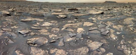
IMAGE....NASA’s Curiosity rover continues to search for signs that Mars’ Gale Crater conditions could support microbial life. Credit NASA/JPL-Caltech/MSSS
2 notes
·
View notes
Link
21 Min Read The Marshall Star for February 14, 2024 Marshall Chief Scientist Provides Valuable Insight into NASA Moonquake Study By Jonathan Deal The Moon holds clues to the evolution of Earth, the planets, and the Sun, and a new NASA-funded study is helping scientists better understand some of the mysteries beneath the surface of our nearest cosmic neighbor. The co-author of that study is chief scientist of NASA’s Marshall Space Flight Center, Renee Weber, who is also a member of NASA’s Artemis Science Team – a broad group of scientists from around the agency working to commence a new era of deep space science and exploration. As a lunar seismologist and lunar geophysicist, Weber provides expertise to the Artemis Science Team, including knowledge of the types of seismic events that can occur on the Moon, to better understand its internal geology and surface environment. The epicenter of one of the strongest moonquakes recorded by the Apollo Passive Seismic Experiment was in the lunar south polar region. However, the exact location of the epicenter could not be accurately determined. A cloud of possible locations (magenta dots and light blue polygon) of the strong shallow moonquake using a relocation algorithm specifically adapted for very sparse seismic networks are distributed near the pole. Blue boxes show locations of proposed Artemis III landing regions. Lobate thrust fault scarps are shown by small red lines. The cloud of epicenter locations encompasses a number of lobate scarps and many of the Artemis III landing regions.NASA/LROC/ASU/Smithsonian Institution The latest study revealed that the Moon is still geologically active and presents evidence that tectonic faults, generated as the Moon’s interior gradually cools and shrinks, are found near some of the areas NASA identified as candidate landing regions for Artemis III – the first Artemis mission planned to have a crewed lunar landing. “This study looked at tectonic faults and steep slopes in the lunar South polar region and found that some areas are susceptible to seismic shaking and regolith landslides,” Weber said. “Once the faults were mapped, we calculated the sizes of potential moonquakes that could be generated to create a map of seismic hazard in the vicinity of tectonic faults and steep slopes.” The study discovered that relatively small, young thrust faults, called lobate scarps, are widely distributed in the lunar crust. The scarps form where contractional forces break the crust and push, or thrust, rock on one side of the fault up and over rock on the other side. The contraction is caused by cooling of the Moon’s still-hot interior and tidal forces exerted by Earth, resulting in global shrinking. The scarps were identified in images taken by the Lunar Reconnaissance Orbiter Camera onboard NASA’s LRO (Lunar Reconnaissance Orbiter). The formation of the faults is accompanied by seismic activity in the form of shallow-depth moonquakes. Such shallow moonquakes were recorded by the Apollo Passive Seismic Network, a series of seismometers deployed by the Apollo astronauts, and could potentially also be recorded by a new seismic instrument scheduled to launch next year aboard an upcoming CLPS (Commercial Lunar Payload Services) flight. That instrument – the Farside Seismic Suite – will return the agency’s first seismic data from the far side of the Moon, helping scientists to understand the region’s tectonic activity. The data may also reveal how often the lunar far side is impacted by small meteorites and determine if the seismicity is different on the far side of the Moon from what was measured during Apollo on the lunar near side. “To better understand the seismic hazard posed to future human activities on the Moon, we need new seismic data, not just at the South Pole, but globally,” Weber said. “Missions like the upcoming Farside Seismic Suite, as well as future potential missions like the Lunar Geophysical Network concept, will expand upon measurements made during Apollo and add to our knowledge of global seismicity.” Renee Weber is chief scientist at NASA’s Marshall Space Flight Center.NASA As NASA develops long-term infrastructure on the lunar surface, Weber’s research will provide invaluable insight for the Artemis Science Team that will be refining mission architectures that preserve flexibility for science and operations at a variety of landing sites and will apply new scientific knowledge, such as continued research on seismic measurements, gathered along the way. “Being able to go back to the Moon, gather more data, and pick up more samples will help us improve our understanding of the Moon and answer our fundamental questions – how did it form? How did it evolve? Where are the resources? More seismic measurements like the ones conducted during Apollo could help us better characterize seismicity in the lunar South Pole region,” Weber said. The study does not impact the Artemis III landing region selection process, according to Weber, because estimating how often a specific region experiences a moonquake is difficult to do accurately, and like earthquakes, scientists can’t predict moonquakes. Additionally, for a shorter duration mission like Artemis III, the likelihood of experiencing hazards due to seismic shaking is much lower. As NASA develops long-term infrastructure, the agency will identify potential regions for where different elements can be established closer to the dates of future Artemis missions. In this site selection process, some of the factors for consideration could be geographic characteristics such as proximity to tectonic features and terrain, making Weber’s research all the more valuable. Deal is a public affairs officer with Marshall’s Office of Communications. › Back to Top Solar Sail Technology Passes Crucial Deployment Test By Wayne Smith In his youth, NASA technologist Les Johnson was riveted by the 1974 novel “The Mote in God’s Eye,” by Jerry Pournelle and Larry Niven, in which an alien spacecraft propelled by solar sails visits humanity. Today, Johnson and a NASA team are preparing to test a similar technology. NASA continues to unfurl plans for solar sail technology as a promising method of deep space transportation. The agency cleared a key technology milestone in January with the successful deployment of one of four identical solar sail quadrants. The deployment was showcased Jan. 30 at Redwire Corp.’s new facility in Longmont, Colorado. NASA’s Marshall Space Flight Center leads the solar sail team, comprised of prime contractor Redwire, which developed the deployment mechanisms and the nearly 100-foot-long booms, and subcontractor NeXolve, of Huntsville, which provided the sail membrane. In addition to leading the project, Marshall developed the algorithms needed to control and navigate with the sail when it flies in space. NASA and industry partners used two 100-foot lightweight composite booms to unfurl the 4,300-square-foot sail quadrant for the first time Oct. 13, 2022, at Marshall Space Flight Center, making it the largest solar sail quadrant ever deployed at the time. On Jan. 30, 2024, NASA cleared a key technology milestone at Redwire’s new facility in Longmont, Colorado, with the successful deployment of one of four identical solar sail quadrants.NASA The sail is a propulsion system powered by sunlight reflecting from the sail, much like a sailboat reflects the wind. While just one quarter of the sail was unfurled in the deployment at Redwire, the complete sail will measure 17,780 square feet when fully deployed, with the thickness less than a human hair at 2 and a half microns. The sail is made of a polymer material coated with aluminum. NASA’s Science Mission Directorate recently funded the solar sail technology to reach a new technology readiness level, or TRL 6, which means it’s ready for proposals to be flown on science missions. “This was a major last step on the ground before it’s ready to be proposed for space missions,” Johnson, who has been involved with sail technology at Marshall for about 25 years, said. “What’s next is for scientists to propose the use of solar sails in their missions. We’ve met our goal and demonstrated that we’re ready to be flown.” A solar sail traveling through deep space provides many potential benefits to missions using the technology because it doesn’t require any fuel, allowing very high propulsive performance with very little mass. This in-space propulsion system is well suited for low-mass missions in novel orbits. “Once you get away from Earth’s gravity and into space, what is important is efficiency and enough thrust to travel from one position to another,” Johnson said. Some of the missions of interest using solar sail technology include studying space weather and its effects on the Earth, or for advanced studies of the north and south poles of the Sun. The latter has been limited because the propulsion needed to get a spacecraft into a polar orbit around the Sun is very high and simply not feasible using most of the propulsion systems available today. Solar sail propulsion is also possible for enhancing future missions to Venus or Mercury, given their closeness to the Sun and the enhanced thrust a solar sail would achieve in the more intense sunlight there. Moreover, it’s the ultimate green propulsion system, Johnson said – as long as the Sun is shining, the sail will have propulsion. Where the sunlight is less, he envisions a future where lasers could be used to accelerate the solar sails to high speeds, pushing them outside the solar system and beyond, perhaps even to another star. “In the future, we might place big lasers in space that shine their beams on the sails as they depart the solar system, accelerating them to higher and higher speeds, until eventually they are going fast enough to reach another star in a reasonable amount of time.” Learn more about solar sails and other NASA advanced space technology. Smith, a Media Fusion employee and the Marshall Star editor, supports the Marshall Office of Communications. › Back to Top NASA Sets Coverage for SpaceX, Intuitive Machines First Moon Mission As part of NASA’s CLPS (Commercial Lunar Payload Services) initiative and Artemis campaign, SpaceX is targeting no earlier than 12:05 a.m. CST on Feb. 15 for a Falcon 9 launch of Intuitive Machines’ first lunar lander to the Moon’s surface. Liftoff will be from Launch Complex 39A at the agency’s Kennedy Space Center. The launch of the mission was postponed Feb. 13 due to off-nominal methane temperatures prior to stepping into methane load. The Nova-C lunar lander is encapsulated within the fairing of a SpaceX Falcon 9 rocket in preparation for launch as part of NASA’s CLPS (Commercial Lunar Payload Services) initiative and Artemis campaign.SpaceX Live launch coverage will air on NASA+, NASA Television, the NASA app, and the agency’s website. NASA TV launch coverage begins at 11:20 p.m. Coverage is subject to change based on real-time operational activities. Follow the Artemis blog for updates. Intuitive Machines’ Nova-C lander is expected to land on the Moon on Feb. 22. Among the items on its lander, the IM-1 mission will carry NASA science and technology instruments focusing on plume-surface interactions, space weather/lunar surface interactions, radio astronomy, precision landing technologies, and a communication and navigation node for future autonomous navigation technologies. Demonstrating autonomous navigation, the Lunar Node-1 experiment, or LN-1, is a radio beacon designed to support precise geolocation and navigation observations for landers, surface infrastructure, and astronauts, digitally confirming their positions on the Moon relative to other craft, ground stations, or rovers on the move. LN-1 was developed, built, and tested at NASA’s Marshall Space Flight Center. › Back to Top Telescopes Show the Milky Way’s Black Hole is Ready for a Kick An artist’s illustration depicts the findings of a new study about the supermassive black hole at the center of our galaxy called Sagittarius A* (abbreviated as Sgr A*). As reported in a press release, this result found that Sgr A* is spinning so quickly that it is warping spacetime – that is, time and the three dimensions of space – so that it can look more like a football. These results were made with NASA’s Chandra X-ray Observatory and the National Science Foundation’s Karl G. Jansky Very Large Array, or VLA. A team of researchers applied a new method that uses X-ray and radio data to determine how quickly Sgr A* is spinning based on how material is flowing towards and away from the black hole. They found Sgr A* is spinning with an angular velocity that is about 60% of the maximum possible value, and with an angular momentum of about 90% of the maximum possible value. This artist’s illustration depicts the findings of a new study about the supermassive black hole at the center of our galaxy called Sagittarius A* (abbreviated as Sgr A*). This result found that Sgr A* is spinning so quickly that it is warping spacetime – that is, time and the three dimensions of space – so that it can look more like a football.NASA/CXC/M.Weiss Black holes have two fundamental properties: their mass (how much they weigh) and their spin (how quickly they rotate). Determining either of these two values tells scientists a great deal about any black hole and how it behaves. In the past, astronomers made several other estimates of Sgr A*’s rotation speed using different techniques, with results ranging from Sgr A* not spinning at all to it spinning at almost the maximum rate. The new study suggests that Sgr A* is, in fact, spinning very rapidly, which causes the spacetime around it to be squashed down. The illustration shows a cross-section of Sgr A* and material swirling around it in a disk. The black sphere in the center represents the so-called event horizon of the black hole, the point of no return from which nothing, not even light, can escape. Looking at the spinning black hole from the side, as depicted in this illustration, the surrounding spacetime is shaped like a football. The faster the spin the flatter the football. The yellow-orange material to either side represents gas swirling around Sgr A*. This material inevitably plunges towards the black hole and crosses the event horizon once it falls inside the football shape. The area inside the football shape but outside the event horizon is therefore depicted as a cavity. The blue blobs show jets firing away from the poles of the spinning black hole. Looking down on the black hole from the top, along the barrel of the jet, spacetime is a circular shape. Chandra X-ray image of Sagittarius A* and the surrounding region.NASA/CXC/Univ. of Wisconsin/Y.Bai, et al. A black hole’s spin can act as an important source of energy. Spinning supermassive black holes produce collimated outflows such as jets when their spin energy is extracted, which requires that there is at least some matter in the vicinity of the black hole. Because of limited fuel around Sgr A*, this black hole has been relatively quiet in recent millennia with relatively weak jets. This work, however, shows that this could change if the amount of material in the vicinity of Sgr A* increases. To determine the spin of Sgr A*, the authors used an empirically based technique referred to as the “outflow method” that details the relationship between the spin of the black hole and its mass, the properties of the matter near the black hole, and the outflow properties. The collimated outflow produces the radio waves, while the disk of gas surrounding the black hole is responsible for the X-ray emission. Using this method, the researchers combined data from Chandra and the VLA with an independent estimate of the black hole’s mass from other telescopes to constrain the black hole’s spin. The paper describing these results led by Ruth Daly (Penn State University) is published in the January 2024 issue of the Monthly Notices of the Royal Astronomical Society and appears online. The other authors are Biny Sebastian (University of Manitoba, Canada), Megan Donahue (Michigan State University), Christopher O’Dea (University of Manitoba), Daryl Haggard (McGill University) and Anan Lu (McGill University). NASA’s Marshall Space Flight Center manages the Chandra program. The Smithsonian Astrophysical Observatory’s Chandra X-ray Center controls science operations from Cambridge, Massachusetts, and flight operations from Burlington, Massachusetts. › Back to Top NASA Expedition 71 Astronauts to Conduct Research Aboard Space Station Studies of neurological organoids, plant growth, and shifts in body fluids are among the scientific investigations that NASA astronauts Matthew Dominick, Michael Barratt, Jeanette Epps, and Tracy C. Dyson will help support aboard the International Space Station as part of Expedition 71. NASA’s SpaceX Crew-8 mission is targeting launch to the space station later this month. A flag for Crew-8 will be raised Feb. 26 outside the HOSC (Huntsville Operation Support Center) at NASA’s Marshall Space Flight Center. The HOSC is a multi-mission facility that provides engineering and mission operations support for NASA’s Commercial Crew Program, Space Launch System rocket, Artemis lunar science missions, and science conducted on the space station. Brain organoid cells from the previous investigation Cosmic Brain Organoids are made of cells from people with Parkinson’s Disease and primary progressive multiple sclerosis. The sixth space station organoid investigation funded by the National Stem Cell Foundation, HBOND, includes for the first time Alzheimer’s iPSCs and testing of the effects of drugs in development to treat neuroinflammation.New York Stem Cell Research Institute The Payload Operations Integration Center within HOSC operates, plans, and coordinates the science experiments onboard the space station 365 days a year, 24 hours a day. Here are details on some of the work scheduled during this upcoming expedition aboard the microgravity laboratory: Modeling Neuroinflammation HBOND (Human Brain Organoid Models for Neurodegenerative Disease & Drug Discovery) studies the mechanisms behind neuroinflammation, a common feature of neurodegenerative disorders. Researchers create organoids using patient-derived iPSCs (induced pluripotent stem cells) from patients who have Parkinson’s disease and primary progressive multiple sclerosis. The sixth space station organoid investigation funded by the National Stem Cell Foundation, HBOND includes for the first time Alzheimer’s iPSCs and testing of the effects of drugs in development to treat neuroinflammation. Results could help improve diagnostics, provide insights into the effects of aging, accelerate drug discovery, and identify therapeutic targets for patients suffering from neurodegenerative diseases. The organoid models also could provide a way to anticipate how extended spaceflight affects the brain and support development of countermeasures. Protecting Plants from Spaceflight Stressors Plants can serve as a source of food and provide other life-support services on long-term missions to the Moon and Mars. The Study on Plant Responses Against the Stresses of Microgravity and High Ultraviolet Radiation in Space (Plant UV-B) examines how stress from microgravity, UV radiation, and the combination of the two affect plants at the molecular, cellular, and whole organism levels. Results could increase understanding of plant growth in space and support improvements in plant cultivation technologies for future missions. This image shows the Plant Experiment Unit (PEU) hardware for the Plant UV-B investigation.NASA Reversing Fluid Shifts Weightlessness causes fluids in the body to move toward the head, which can cause changes in eye structure and vision known as Spaceflight Associated Neuro-ocular Syndrome (SANS) along with other health problems. Mitigating Headward Fluid Shifts with Veno-constrictive Thigh Cuffs During Spaceflight (Thigh Cuff) examines whether thigh pressure cuffs could provide a simple way to counter this shift in body fluids and help protect astronauts from SANS and other issues on future missions to the Moon and Mars. Thigh cuffs also could help treat or prevent problems for patients on Earth who have conditions that cause fluid accumulation in the head, such as long-term bedrest and diseases. Incredible Edible Algae Arthrospira-C (Art-C), an investigation from ESA (European Space Agency) analyzes how the cyanobacterium Limnospira responds to spaceflight conditions and whether it produces the same quantity and quality of oxygen and biomass in space as on Earth. These microalgae, also known as Spirulina, could be used to remove carbon dioxide exhaled by astronauts, which can become toxic in an enclosed spacecraft, and to produce oxygen and fresh food as part of life support systems on future missions. Correct predictions of oxygen and biomass yields are crucial for design of life support systems using bioprocesses. Spirulina also has been shown to have radioprotective properties and eating it could help protect space travelers from cosmic radiation, as well as conserve healthy tissue in patients undergoing radiation treatment on Earth. Search this database of scientific experiments to learn more about those mentioned above. › Back to Top NASA Awards Inaugural Grants to Support Emerging Research Institutions NASA has awarded $3.7 million to 11 teams to support new collaborations between the agency and United States institutions not historically part of the agency’s research enterprise. These are the first awards given through a new program from the agency’s SMD (Science Mission Directorate) to improve diversity, equity, inclusion, and accessibility in the science and engineering communities, as well as NASA’s workforce. “As the agency continues to build relationships with under-resourced institutions through initiatives like the bridge program, we are intentionally increasing equitable access to NASA for the best and brightest talents in our nation,” said Shahra Lambert, NASA senior advisor for engagement. “These partnerships will help NASA develop a diverse and capable workforce to further our understanding of the cosmos.” NASA’s SMD Bridge Program provides seed funding for research projects that will build strong foundations for long-lasting relationships with the agency. The projects offer hands-on training and mentorship for students, as well as new research opportunities for faculty, to help science and engineering students transition into graduate schools, employment by NASA, or science, technology, engineering, and math careers generally. The teams are led by faculty at institutions that represent new collaborations for NASA. These include Hispanic-serving institutions, Historically Black Colleges and Universities, Asian American and Native American Pacific Islander-serving institutions, and primarily undergraduate institutions. The research projects connect these institutions to seven NASA centers, including the agency’s Marshall Space Flight Center, and could benefit more than 100 students. “We applaud this inaugural cohort of grant recipients for their innovative research projects, which will make important connections between students, faculty, and NASA,” said Michael New, Science Mission Directorate deputy associate administrator for research at NASA Headquarters. “These awards are a first and important step for the SMD Bridge Program in supporting long-term relationships toward creating a more diverse and robust STEM workforce.” There is an additional opportunity to apply for seed funding through the SMD Bridge Program. Applications are open until March 29. The following projects were selected as the first cohort to receive seed funding: Additive Manufacturing of Electronics for NASA Applications This project, a collaboration between Florida A&M University and Marshall and NASA’s Goddard Space Flight Center, will explore technology solutions through additive manufacturing approaches to manufacture strain and gas sensors. Diversifying Student Pipelines in STEM: Environmental Pollution Reduction Inspired by Planetary Science This project, a collaboration that brings California State University, Los Angeles, together with NASA’s Jet Propulsion Laboratory, and California State Polytechnic University, Pomona, draws from the field of planetary science to address environmental pollution. FireSage: SJSU-NASA ARC Bridge Seed Program FireSage is a collaboration between San Jose State University’s Wildfire Interdisciplinary Research Center and the Earth Science Division at NASA’s Ames Research Center. It engages students in a computing, artificial intelligence, and machine learning research project and training activities in wildfire science. Hampton University STEM Experience with NASA Langley Research Center Doppler Aerosol Wind Lidar This collaboration between Hampton University and NASA’s Langley Research Center offers a foundation in the advancement of planetary boundary layer studies with Lidar remote sensing. Development of Antireflection Coatings for Future NASA Missions This project is a collaboration between Delaware State University and Goddard, working with transparent, electrically conductive films to design and produce an environmentally durable anti-reflection coating for guidance, navigation, and control Lidar. CUBES: Capacity Building Using CubeSats for Earth Science This collaboration between Tuskegee University, the Laboratory for Atmospheric Science and Physics at University of Colorado, and Ames uses CubeSats to provide faculty and students with experience designing and executing science mission flight projects. Space Materials and Microbiome Research: A Bridge to Future JSC Workforce In this project, the University of Houston-Clear Lake collaborates with NASA’s Johnson Space Center. The project’s Composite Materials track will develop a protective nanocomposite shield for spacecraft materials, while the Microbiome track will create a comprehensive library of draft bacterial genomes. The HALOQUEST: Halobacterium Astrobiological Laboratory for Observing and Questioning Extraterrestrial Signatures and Traits Project This collaboration between California State University, Northridge, and JPL will study Halobacterium salinarum NRC-1 grown under simulated stressful environmental conditions, which could help understand possibilities for life on other planets. Observations of Ice-Water and Isotopes Using Mid-Infrared Laser Heterodyne Radiometer LIDAR In collaboration with Goddard, Delaware State University will develop Earth science, planetary exploration, and sensing technologies, including a lunar rover payload with instruments to simultaneously detect and correlate water isotopes with other trace gas species. Application of Remote Sensing for Predicting Mosquito-Borne Disease Outbreaks This project is a collaboration between Southern Nazarene University and JPL to identify areas at risk for mosquito-borne disease outbreaks using remote sensing data. Building a Diverse, Sustainable, and Robust Undergraduate-to-Graduate STEM Network through Inter-Institutional, Interdisciplinary Research Collaborations in Complex Fluids/Soft Matter This project is a collaboration between Colorado Mesa University and NASA’s Glenn Research Center to strengthen and grow a research, education, and training network centered around problems in complex fluids and soft matter, with initial emphasis on heat transfer and multiphase flows. › Back to Top Juno, Lucy Missions Highlighted on ‘This Week at NASA’ Two missions that are part of programs managed by NASA’s Marshall Space Flight Center for the agency’s Science Mission Directorate are featured in “This Week @ NASA,” a weekly video program broadcast on NASA-TV and posted online. NASA’s Lucy spacecraft recently completed the second and largest planned main engine burn of its 12-year mission. These burns, combined with the mission’s second Earth gravity assist maneuver targeted for December 2024, will help Lucy transition from its current orbit around the Sun to a new orbit that will carry it beyond the orbit of Jupiter and into the realm of the never-before-explored Jupiter Trojan asteroids. NASA’s Goddard Space Flight Center provides overall mission management, systems engineering, and safety and mission assurance. Lockheed Martin Space in Littleton, Colorado, built the spacecraft. Lucy is the 13th mission in NASA’s Discovery Program. Marshall manages the Discovery Program for the Science Mission Directorate at NASA Headquarters. On Feb. 3, NASA’s Juno spacecraft made a second close flyby of Jupiter’s moon Io. Like Juno’s previous flyby of Io in late December 2023, this second pass took Juno about 930 miles above Io’s surface. The twin flybys were designed to gain new insight into how the moon’s volcanic engine works and investigate whether a global magma ocean exists under the moon’s rocky, mountainous surface. NASA’s Jet Propulsion Laboratory, a division of Caltech, manages the Juno mission for the principal investigator, Scott J. Bolton, of the Southwest Research Institute in San Antonio. Juno is part of NASA’s New Frontiers Program, which is managed at Marshall for the Science Mission Directorate. Lockheed Martin Space in Denver built and operates the spacecraft. View this and previous episodes at “This Week @NASA” on NASA’s YouTube page. › Back to Top
0 notes
Text
Morocco’s earthquake wasn’t unexpected – building codes must plan for them

- By José A. Peláez Montilla , Universidad de Jaén , The Conversation -
More than 2,000 people died when a powerful magnitude 6.8 earthquake struck Morocco on 8 September.
The epicentre was in the High Atlas Mountains, 71km (44 miles) south-west of Marrakesh. Moina Spooner, from The Conversation Africa, asked José A. Peláez, a professor in geophysics who has carried out research on seismic activity in Morocco, about what led to this situation.
What geological factors contributed to this earthquake?
The Earth’s surface is constituted of several tectonic plates, large segments of the planet’s outer layer, which move against each other. This movement is responsible for various geological phenomena, such as earthquakes, volcanoes, and the formation of mountains and ocean basins.
The tectonic activity in Morocco primarily involves the convergence of the Eurasian and the Nubian (African) plates. The Eurasian Plate pushing against the Nubian Plate is what led to the formation of the Atlas Mountains, which run through Morocco, Algeria and Tunisia. The mountains are where the epicentre of this recent earthquake was.
Currently, the collisions between the plates are causing a shortening of the Atlas Mountains, explaining the area’s seismicity. We know this because of data from GPS measurements, which show that they are moving about 1 millimetre closer to each other every year.
This shortening and compression is causing what are known as faults, huge friction between plates. These faults are the likely cause of this earthquake. Scientists think that these faults have been active for a long time, going back a few million years.
In addition, as pointed out by various researchers, the High Atlas Mountains have a unique geological feature where the Earth’s outermost and hard layer, called the lithosphere, is thinner than usual, combined with an unusual rise of the mantle. All these features could have influenced the occurrence of this high magnitude earthquake.
What is Morocco’s history of earthquakes?
Seismic activity and its phenomena, like earthquakes, are not unusual in Morocco.
Over the last thousand years, earthquakes affecting Morocco have tended to take place mainly in two areas. Offshore, along the Azores-Gibraltar transform fault and the Alboran Sea, and another one onshore, along the Rif mountains in northern Morocco and the Tell Atlas mountain range in north-western Algeria. Earthquakes along the Atlas Belt are smaller in number, but not unusual.
The most significant, recent earthquakes affecting Morocco were in 1994, 2004 and 2016, with magnitudes ranging between 6.0 and 6.3. These occurred in the most seismically active region in Morocco and also in the western Mediterranean region.
A bit further back in history, there was the devastating Agadir earthquake in February 1960, with a magnitude of 6.3. It was located around the boundary between the western High Atlas and the Anti Atlas, to the south. Available data indicates that between 12,000 and 15,000 people died due to this event. In addition, near the location of the recent event, there was another earthquake in 1955, with an estimated magnitude of about 5.8.
Even further back, prior to the establishment of seismometers, several significant events were recorded in Morocco. Among them were the 1624 Fès earthquake, with an estimated magnitude of 6.7, and the 1731 Agadir earthquake, with a magnitude of 6.4.
Could it have been predicted?
Earthquakes cannot be predicted, even with the current knowledge in seismology. In fact, many researchers think that it will not be possible to do so in the future either. What seismologists can do is establish the areas in which earthquakes are most likely to occur, even establish the probability of their occurrence and its uncertainty.
This is that we call a long-term prediction, carried out from specific seismic hazard studies in the region. They are based on knowledge of past seismicity in the area, both historical and instrumental, and on the existence and knowledge of active tectonic structures (faults) that could generate earthquakes. The greater the knowledge that one has on these two topics – seismicity and active faults in the region – the more knowledge one will have about the future seismicity that may occur in the area, and the less the uncertainty will be.
Seismic hazard studies also include the study of near-surface soil conditions and the characteristics of buildings. This helps to assess the possible damage from these potential earthquakes.
What can be done to lessen the impact of future earthquakes in Morocco?
The best tool we have to mitigate the impact of earthquakes is to conduct reliable seismic hazard studies. The results of these must then be implemented into national building codes. This way engineers can incorporate seismic safety into building designs.
Building codes need to take into account several factors, including the characteristics of the soil, the way seismic waves move and how the soil can amplify its movement during an earthquake. Also the expected shaking of the ground, which influences the behaviour and damage of buildings. These factors vary from one city to another, and in some cases from one district to another.
Seismologists know that earthquakes do not kill people – buildings do. Buildings with lack of regulation and lack of structural support are potential killers in high seismic hazard areas. Building codes must therefore be mandatory, and should be updated periodically. As more is learned about earthquake geology and the impact of earthquakes on buildings, building codes should be updated regularly. This is the best way to protect ourselves against these catastrophic phenomena. Territorial planners and rulers must know this and take it into account.
José A. Peláez Montilla, Professor of Geophysics, Universidad de Jaén
This article is republished from The Conversation under a Creative Commons license. Read the original article.
--
Read Also
Turkey-Syria earthquakes: A seismologist explains what has happened
#earthquake#morocco#africa#north africa#seism#seismology#natural disasters#Earthquakes#Morocco#tectonic plates
0 notes
Text
Slime in the sea is not inherently unusual. “Mucus is everywhere,” says Michael Stachowitsch, a marine ecologist at the University of Vienna. “There’s no marine organism that doesn’t produce mucus, from the lowly snail to the slimy fish.” But in healthy waters, mucus doesn’t amass to epic proportions. The current sea-snot outbreak can be blamed on phytoplankton, a type of algae that produces the small bits of mucus that turn into flakes of marine snow. When these phytoplankton receive an infusion of imbalanced nutrients from fertilizer runoff or untreated wastewater, they make an overabundance of mucus. Beads of that mucus accumulate into stringers, which accumulate into clouds, which accumulate into the unending sheets now washing up on Turkey’s coast.
But pollution alone doesn’t explain the appearance of so much sea snot—or marine mucilage, to use the scientific term. This much slime buildup also requires specific weather conditions: hot and calm. In spring and summer, the sun heats up the top layer of seawater, leaving a layer of cool, denser water underneath. (Salinity also plays a role in the density gradient: Saltier water will sink beneath fresher water.) Because of this gradient, the mucus will sink until it starts to float; then it lingers. The longer it stays, the more it accumulates. And without strong winds or storms, nothing creates turbulence to churn the water and rip the mucus apart.
Bacteria trapped in the mucus will eventually start to eat and digest it, creating air bubbles that ultimately float the whole sheet of sea snot up to the surface. In the Adriatic Sea, the arm of the Mediterranean just east of the Italian peninsula, the floating mucus can dry and toughen in the sun. Seagulls are known to walk on it.
Mass outbreaks of sea snot have appeared dozens of times in the Adriatic over the past three centuries, probably because its geography and calm winds create the perfect conditions for large sheets to form. Sea snot has had big economic consequences there. “The main problems are fisheries and tourism,” Michele Giani, an oceanographer at the National Institute of Oceanography and Applied Geophysics, in Italy, told me. Boats cannot go to sea at all because mucus clogs up the seawater intake that cools the motor. “A motor can have a meltdown within a minute,” Stachowitsch said. Fishing nets become slimy and heavy. And tourists, of course, want nothing to do with the mess. It doesn’t help that as sea snot degrades on the surface, its smell can turn quite nasty too.
The first description of mare sporco, or “dirty sea,” in Italian dates back to 1729. But in the early 2000s, marine mucilage started breaking out pretty much every year, which scientists, in a 2009 paper, linked to climate change. (Huge swaths of marine mucilage have also turned up near Turkey at least once before, in 2007.) You might think of the snot as a symptom of “ocean flu,” says Antonio Pusceddu, a marine ecologist at the University of Cagliari, in Italy, who co-authored that paper: The snot’s appearance is a sign of deeper sickness in the sea, caused by climate change and pollution.
The link between marine mucilage on the surface and the clouds and stringers underwater became clear during the 1980s, when researchers diving in the Adriatic first observed the unusual masses. Scientists had missed this phenomenon earlier, Stachowitsch said, “because the instruments that were used to bring up water samples from the ocean were quite brutal, so they shook up the water,” destroying the mucus. Humans could see it only if they went down themselves, either with scuba gear or in submersibles. Gerhard Herndl, an oceanographer now at the University of Vienna, told me that while diving in the ’80s, he mistook the first cloud of mucus he ever saw for a shark. Until that moment, he had not known that sea snot could grow to such behemoth proportions.
The mucus floating underwater was fascinating—even beautiful—but what scientists saw on the seafloor was disturbing. They already knew that unsightly layers of the mucus could float to the surface. Now they discovered that they could also sink, covering corals, sponges, brittle stars, mollusks, and any other unlucky creatures on the seafloor, cutting them off from oxygen. “They’re literally smothered,” says Alice Alldredge, an oceanographer at UC Santa Barbara. “Sure, it’s uncomfortable for us as human beings to have all this gunk at the surface. But the bottom-dwelling organisms are going to die.” An ecosystem takes years to fully recover from such a mass mortality.
— Why Turkey's Coast Is Covered in Sea Snot
#sarah zhang#environmentalism#climate change#global warming#ecology#oceanology#marine biology#microbiology#mucilage#turkey#italy#sea of marmara#adriatic sea#algae#phytoplankton#michael stachowitsch#michele giani#antonio pusceddu#alice alldredge
0 notes
Text
NASA Selects First Lunar Instruments for Artemis Astronaut Deployment - NASA
New Post has been published on https://sunalei.org/news/nasa-selects-first-lunar-instruments-for-artemis-astronaut-deployment-nasa/
NASA Selects First Lunar Instruments for Artemis Astronaut Deployment - NASA
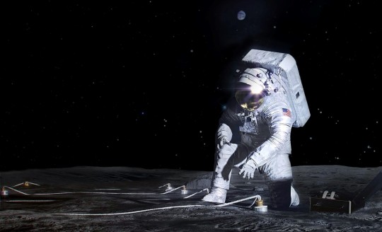
NASA has chosen the first science instruments designed for astronauts to deploy on the surface of the Moon during Artemis III. Once installed near the lunar South Pole, the three instruments will collect valuable scientific data about the lunar environment, the lunar interior, and how to sustain a long-duration human presence on the Moon, which will help prepare NASA to send astronauts to Mars.
“Artemis marks a bold new era of exploration, where human presence amplifies scientific discovery. With these innovative instruments stationed on the Moon’s surface, we’re embarking on a transformative journey that will kick-start the ability to conduct human-machine teaming – an entirely new way of doing science,” said NASA Deputy Administrator Pam Melroy. “These three deployed instruments were chosen to begin scientific investigations that will address key Moon to Mars science objectives.”
The instruments will address three Artemis science objectives: understanding planetary processes, understanding the character and origin of lunar polar volatiles, and investigating and mitigating exploration risks. They were specifically chosen because of their unique installation requirements that necessitate deployment by humans during moonwalks. All three payloads were selected for further development to fly on Artemis III that’s targeted to launch in 2026, however, final manifesting decisions about the mission will be determined at a later date. Members of these payload teams will become members of NASA’s Artemis III science team.
The Lunar Environment Monitoring Station (LEMS) is a compact, autonomous seismometer suite designed to carry out continuous, long-term monitoring of the seismic environment, namely ground motion from moonquakes, in the lunar south polar region. The instrument will characterize the regional structure of the Moon’s crust and mantle, which will add valuable information to lunar formation and evolution models. LEMS previously received four years of NASA’s Development and Advancement of Lunar Instrumentation funding for engineering development and risk reduction. It is intended to operate on the lunar surface from three months up to two years and may become a key station in a future global lunar geophysical network. LEMS is led by Dr. Mehdi Benna, from the University of Maryland, Baltimore County.
Lunar Effects on Agricultural Flora (LEAF) will investigate the lunar surface environment’s effects on space crops. LEAF will be the first experiment to observe plant photosynthesis, growth, and systemic stress responses in space-radiation and partial gravity. Plant growth and development data, along with environmental parameters measured by LEAF, will help scientists understand the use of plants grown on the Moon for both human nutrition and life support on the Moon and beyond. LEAF is led by Christine Escobar of Space Lab Technologies, LLC, in Boulder, Colorado.
The Lunar Dielectric Analyzer (LDA) will measure the regolith’s ability to propagate an electric field, which is a key parameter in the search for lunar volatiles, especially ice. It will gather essential information about the structure of the Moon’s subsurface, monitor dielectric changes caused by the changing angle of the Sun as the Moon rotates, and look for possible frost formation or ice deposits. LDA, an internationally contributed payload, is led by Dr. Hideaki Miyamoto of the University of Tokyo and supported by JAXA (Japan Aerospace Exploration Agency).
“These three scientific instruments will be our first opportunity since Apollo to leverage the unique capabilities of human explorers to conduct transformative lunar science,” said Joel Kearns, deputy associate administrator for exploration in NASA’s Science Mission Directorate in Washington. “These payloads mark our first steps toward implementing the recommendations for the high-priority science outlined in the Artemis III Science Definition Team report.”
Artemis III, the first mission to return astronauts to the surface of the Moon in more than 50 years, will explore the south polar region of the Moon, within 6 degrees of latitude from the South Pole. Several proposed landing regions for the mission are located among some of the oldest parts of the Moon. Together with the permanently shadowed regions, they provide the opportunity to learn about the history of the Moon through previously unstudied lunar materials.
With the Artemis campaign, NASA will land the first woman, first person of color, and its first international partner astronaut on the Moon, and establish long-term exploration for scientific discovery and preparation for human missions to Mars for the benefit of all.
For more information on Artemis science, visit:
https://science.nasa.gov/lunar-science
-end-
Karen Fox / Erin Morton
Headquarters, Washington
202-358-1257 / 202-805-9393
[email protected] / [email protected]
0 notes
Text
What Are The Different Types Of NDT Methods?
There are more than one NDT methods. Non-destructive testing or NDT is an analysis and testing-based technique that is used by industry for evaluating the properties of a component, structure, material, or system for welding defects or characteristic differences and discontinuities without causing any damage to its original part. NDT is also called Non-destructive Inspection (NDI), Non-destructive Evaluation (NDE) or Non-destructive Examination (NDE).
Different Types of NDT Testing Methods
The current NDT testing methods include the following.
1. Acoustic Emission Testing (AE)
Acoustic Emission Testing is a type of passive NDT technique that depends on detecting the short bursts of the ultrasound waves that are emitted from the active cracks under a load. The sensors that are dispersed over the structural surface detect AE. AE can also be detected with the help of ultrasonic flaw detectors from plasticization in stressed surfaces before the crack forms.
2. Electromagnetic Testing (ET)
The method of Electromagnetic Testing makes use of a magnetic field or an electric current that is passed through a conductive part. There are three different kinds of Electromagnetic Testing that include Eddy Current Testing, Remote Field Testing (RFT), and Alternating Current Field Measurement (ACFM).
3. Ground Penetrating Radar (GPR)
Ground Penetrating Radar is a geophysical NDT method that uses an ultrasonic flaw detector machine to send radar pulses through the material’s surface. The waves either get reflected or refracted when they come across a material boundary or a buried object having different electromagnetic properties.
4. Laser Testing Methods (LM)
The Laser Testing Method is divided into three categories that include laser profilometry, holographic testing and laser shearography.
Laser profilometry makes use of a high-speed rotating laser light source along with miniature optics for detecting pitting, cracks, corrosion and erosion when it detects the changes in the surface through a 3D image generation via surface topography.
Holographic testing incorporates a laser for detecting the changes in the surface of the material that is subjected to pressure, vibration or heat.
Laser shearography uses laser light for making the image even before the surface is subjected to stress and creates a new image.
5. Magnetic Flux Leakage (MFL)
The method of Magnetic Flux Leakage makes use of a powerful magnet for creating magnetic fields that saturate the structure of steel such as storage tanks and pipelines. A sensor is used for detecting the changes in the magnetic flux density that shows any kind of reduction due to erosion, corrosion or pitting.
6. Magnetic Particle Testing (MT)
The Magnetic Particle Testing method uses magnetic fields for finding the discontinuities near or at the surface of the ferromagnetic materials. This magnetic field is generated either through a permanent magnet or an electromagnet.
The magnetic field shows any sorts of discontinuities as the magnetic flux lines show leakage that can be seen easily via magnetic particles that are drawn towards the discontinuities.
7. Neutron Radiographic Testing (NR)
Neutron Radiography NDT technique makes use of low beam energy neutrons for penetrating the workpiece. While the beam remains transparent in the metallic materials, most of the organic materials allow this beam to be visible. This helps the internal and structural components to be examined and viewed for detecting flaws.
8. Radiographic Testing (RT)
The technique of Radiographic Testing incorporates radiations that are passed through the test piece for detecting the defects. X-rays are generally used for less dense or thin materials whereas gamma rays are used for denser or thicker objects. The results are then processed by using computed radiography, film radiography, digital radiography, or computed tomography. Whatever method is used, the radiations would show discontinuities in the material because of the higher strength of the radiations.
9. Ultrasonic Testing (UT)
The method of Ultrasonic Testing transmits high-frequency sound into an object for interacting with the features present within the material that attenuate or reflect it by using ultrasonic crack detection. The method of Ultrasonic Testing is broadly classified into Through Transmission (TT), Time of Flight Diffraction (ToFD) and Pulse-Echo (PE).
Choosing the right NDT method is crucial to optimize the performance of the NDT inspection. Since there are so many different kinds of techniques and ultrasonic flaw detectors with each having its distinct characteristics, some are perfectly suited for certain applications while they can be ineffective in the rest of the cases.
Modsonic, specializing in the area of Portable Ultrasonic Flaw Detector, features EINSTEIN-II DGS, an ultrasonic flaw detector that helps in evaluating the flaw size effectively with its built-in DGS/AVG curves and Time Controlled Gain.
Modsonic has also come up with the New Arjun Series Ultrasonic Flaw Detectors that have three different models, Arjun10, Arjun 20 and Arjun 30.
Out of all, Arjun30 is the most advanced ultrasonic flaw detector machine that brings in revolutionary changes in the field of conventional flaw detection through its recordability as well as offline analysis, which wasn’t available in the past.
Despite its smaller size and less weight, the functions and features of Arjun30 meet all the requirements of modern conventional ultrasonic testing.
Arjun30 = Features of Arjun10 + Features of Arjun20 + Recordability and Offline Analysis
1 note
·
View note
Last Seen Blogs

faezaainaka
Untitled

liyuesbian
at your service, my liege

jewbear23
I AM THE ENEMY OF MY OWN DESIGN

gaineboyone
My Weight Gain Blog

gamesharkakaflash
reddy :3