
submonitor
The SUbMonitor
The Sustainable Urban Mobility monitor is a dedicated platform, interested in the different aspects related to the policy and planning of public transport, and the attempts at achieving sustainable urban mobility. Sometimes, we look at other urban issues too.
23 posts
Don't wanna be here? Send us removal request.
Last Seen Blogs

lonestarbattleship
Battleship Texas and more

ning1998
Untitled

syea-say
janna

muzearsiv
MÜZE ARŞİVLERİ

thestargirlfromoon
MoonGirl
Text
Op-ed: Finally high speed? Egypt’s Long awaited HSR Line 1.
One of the most important projects in Egypt to date, albeit requiring (some) urgent extensions to fulfill its potential.
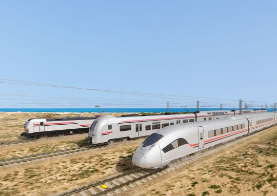
Picture 1: Rendering of the new HSR trains from Siemens press relase, date 28th of May 2022. (Source: Siemens)
An important disclaimer needs to be made: the analysis made here is arm–chair planning. While I am confident enough to publish this piece, this is neither a report nor is it academic. However, I think it is important to raise questions and put forward policy proposals to help make good transit even better. Also any sources used will be either hyperlinked or attached as a PDF.
Egypt’s High-Speed Railway projects provide genuine reasons for optimism. This opinion piece focuses on the High-Speed Railway (HSR) Line 1, which will run from Marsa Matrouh to Ain Sokhna, via West Alexandria and Greater Cairo.
According to the National Authority for Tunnels (NAT), the national agency responsible for the construction of HSR 1, along with Siemens Egypt, the high-speed “express“ trains which will consist of Valero trainsets (akin to Germany’s ICE trains) will reach a top speed of ca. 230 km/h. The “regional” trains will be based on Desiro trainsets (which are akin to Germany’s Regiobahn/ regional trains), which will run at a top speed of ca. 160 km/h.
For reference, the Cairo-Alexandria railway corridor is ca. 200 km. Due to the current conditions of the legacy railway mainline (run by Egypt National Railways - ENR) and factoring in the other stops in between, the train ride between Cairo and Alexandria takes around 3 hours. For other express trains on the line, such as the new Talgo trains, that journey could take up to 2 hours and 30 minutes. The Talgo trains have a top speed of 160 km/h but due to the stops and the conditions of some of the railway segment, the average speed is 80 km/h.
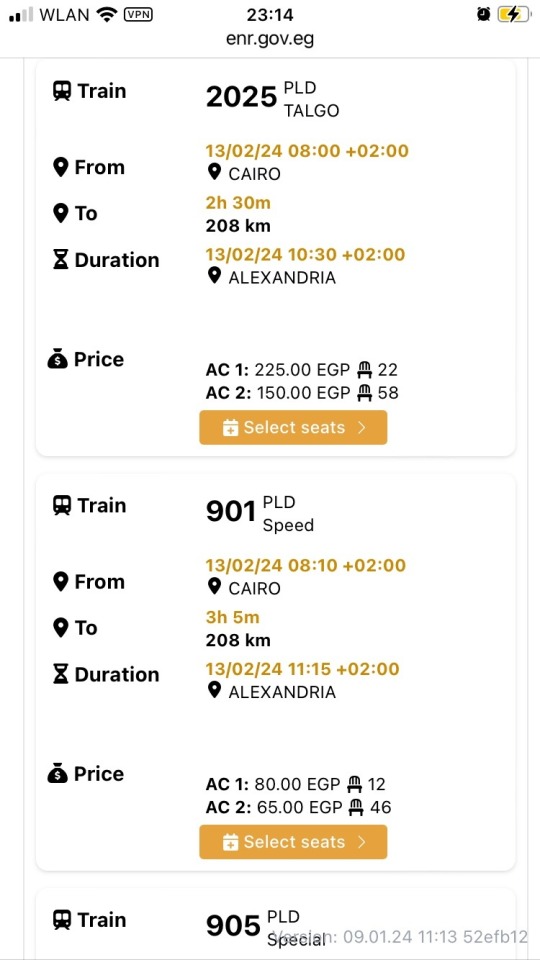
Picture 2: Screenshot showing the average time and distance between Cairo and Alexandria. Notice duratiom difference between Train 2025 (a Talgo train) and 901 a regular “speed” train (Source: ENR official booking website).
With HSR 1, there will be an alternative train route from Cairo to Alexandria (via the area adjacent to the Cairo-Alex Desert Road) that runs on dedicated high speed railway tracks, and will connect Cairo to the North Coast area; the latter only serviced at the moment by a low-frequency legacy single track that runs from Alexandria to Marsa Matrouh. The railway line as it is currently planned, is already going to be a great addition to the Egyptian transport network.
However, some issues can hinder achieving the potential this HSR line has for commuters and travelers alike. Those issues include the distance between the Cairo HSR stations and the nearest urban agglemoration or metro station. Also, many missed opportunities to connect important facilities and areas within the vincinity of the new HSR. Implementing solutions to close these gaps will be a change changer for sustainable mobility in Egypt and would be a good step forward in encouraging the transition to sustainable mobility across the Middle East and North Africa.
What is HSR 1?
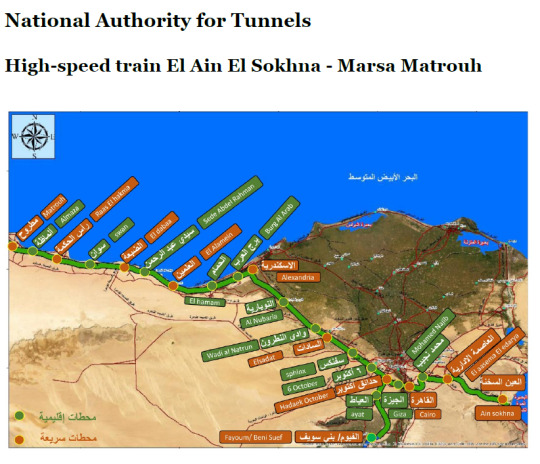
Picture 3: An official map of the HSR Line 1. Stations in green are designated as “Regional” and those in orange are “Express” stations. (Source: National Authority of Tunnels (NAT), Egypt)
The Line begins from Marsa Matrouh on the western end of Egypt’s Mediterranean North Coast, passing by the North Coast towns and cities until Alexandria, then heading to the Greater Cairo Region, passing by the further most western parts of the Nile Delta, before it crosses over the Nile, encircling Giza and Cairo proper, then passes by the outermost outskirts of New Cairo and the New Capital, before terminating at Ain Sokhna on Egypt’s Red Sea. It is, so far, the only direct true RED2MED (Red Sea to Mediterranean Sea) rail link in existence. In addition, there is a planned short link to the Fayoum, south of Giza.
Here is a list of the railway stations along the line:
Legend:
LRT: Light Rail Transit
NAC: New Administrative Capital
HSR: High-Speed Rail
→: Branch off the mainline.
Express: Serviced mainly by Valero trainsets.
Regional: Serviced mainly by Desiro trainsets.
Table 1: A list of the stations and their planned intermodality. (Source: Own work)
One of the issues noticed, from analyzing the information provided online and in the media, and by having a look at Google Earth's latest imagery, one finds that the moment the railway bends away from the North Coast towards Greater Cairo, we start seeing missing connections and gaps.
Below is a breakdown of the issues that I believe are a hinderance to achieving a higher future revenue and utilization of the HSR line 1.
Borg ElArab Int. Airport: passing by but not stopping?

Picture 4: Borg ElArab airport, the only civilian airport that currently serves Alexandria and Borg ElArab area. It also is popular with budget airline travelers, including those heading to Giza and Cairo. (Source: felekmaster, wikimedia).
That didn’t matter much as the railway service on the legacy route served the rural hinterland of the North Coast, and the capacity of the legacy rails there prevented increasing services that could have been useful to the airport.
The North coast section of HSR 1 goes parallel to the legacy railway line from Marsa Matrouh until the town of Borg ElArab, after which it diverges into two sections: a section going to Alexandria in the East, and a section that is the continuation of the main HSR line heading southeast. It disturbingly passes by the Airport perimeter, on both its North and East sides, without having a single station or set of tracks heading to the Passenger Terminal.
This will prove crucial in the future, as Borg ElArab airport is set to expand even further and a second passenger terminal, leading to increased traffic in the area.
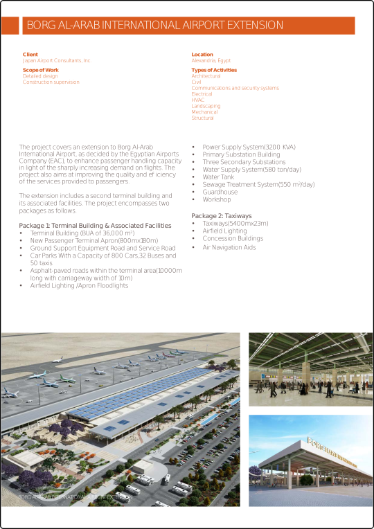
Picture 5: Brochure by Japan Airport Consultants, retrieved from the Engineering Consultants Group SA’s website , detailing the planned expansion of Borg ElArab Airport and Terminal 2’s capacity. (Source: ECGSA.com)
Sadat City station: a tad out of reach?
The station dedicated to Sadat City, a sprawling new town northwest of Cairo, is not directly adjacent to any of the city’s main districts or even close to the city limits. This issue could have been prevented had the station’s location moved around 2 km North West, where it would have been at a nearer location to the city limits. Just moving the station 2 km in that direction makes it easier for those commuting to and from Sadat City to access the HSR line.

Picture 6: Sadat city HSR is ca. 2 km, as the crow flies, from the city limits (shown on maps as dotted red line) of the city it aims to serve. (Source: Google Maps)
Sphinx Airport and Smart Village: why not?
Between Sphinx and 6th of October city, there is a wide gap without a railway station (neither express nor regional) despite the HSR 1 mainline passing by yet not serving Sphinx International Airport (Cairo’s 2nd International airport), Smart Village (a business park with many financial and telecommunications corporations) and AbuRawash Industrial area.
6th of October City: an oversight in need of correcting!
Despite its importance as a major inter-modal node with the Monorail West line, and being in the heart of a major metropolitan area like 6th of October city, it’s currently designated as a “Regional” only station. This obviously needs to change.
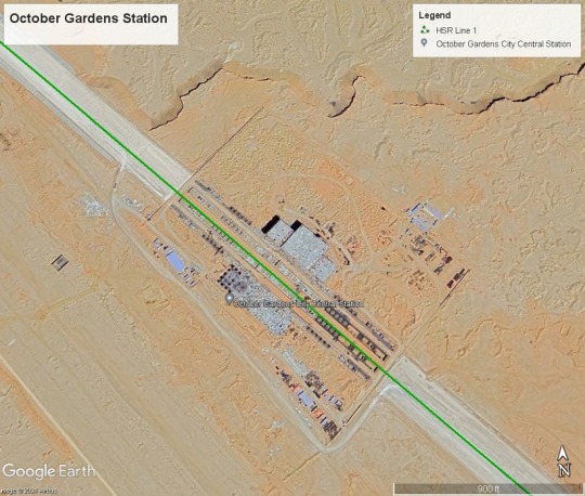
Picture 8: Screenshot of the October Gardens station from Google Earth (Source: Own work using Google Earth)
Although the nearby station “October Gardens/Hadayek October” is planned to be an intermodal station for lines 1 and 2, it is far more logical and far more efficient and revenue minded to either designate the 6th of October station as the intermodal station between HSR 1 and 2, since the area around the station is already built up and central to the 6th of October city. Also, the Monorail West line station is nearby, therefore connecting to other parts of 6th of October city and Giza.

Picture 9: Screenshot of the 6th of October station from Google Earth (Source: Own work using Google Earth)
South Giza: Blocked path?
The new South Giza HSR station is being built on the path of the former railway curve leading from the ENR mainline to the Wahat line. Instead of keeping the railway curve and utilizing it within the station as a potential for quick platform change station, and possibly a cheaper way to connect the HSR to the mainline in the future, the tracks were removed, and station was built atop it.
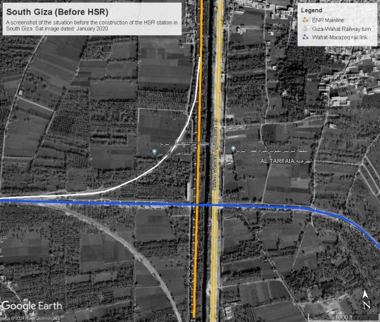
Picture 10: Screenshot of the South Giza area before the start of the HSR construction works, from Google Earth (Source: Own work using Google Earth)

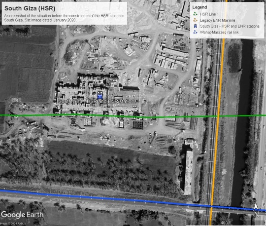
Pictures 11 and 12: Screenshot of the South Giza new HSR and ENR multimodal station. See how a new railway station is being built atop the now demolished Giza-Wahat railway curve. (Source: Own work using Google Earth)
South Cairo/Helwan HSR: A bit far?
Despite being the only HSR station that is within the city limits of Cairo proper, it is by far the farthest station of all to central Cairo. It will be a great service to the residents of Helwan, of course, and that is a positive aspect. However, the Helwan Metro station is a Kopf Bahnhof/ Terminus station, meaning an expansion of the line 1 metro to meet the new railway will be unfortunately out of the question in the foreseeable future.
The closeness of the often overlooked Marazeq bridge, on the other hand, might come to the HSR’s rescue.
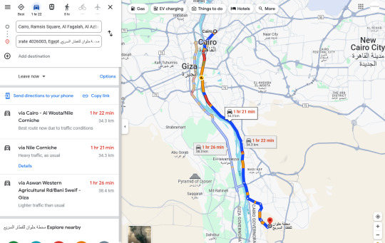

Pictures 13 and 14: Screenshots from Google Maps, with live traffic view, showing how long it would take to travel from Downtown Cairo to the Helwan HSR on an average weekday at 6:15 pm Cairo time (06/02/2024). (Source: Google Maps).

Picture 15: Screenshot of the Helwan Metro terminal station from Google Earth (Source: Google Earth).

Picture 16: Screenshot of Google Maps, with live traffic view, showing how long it would take to travel from the nearest metro station (Helwan) to the new HSR station in South Helwan, on an average weekday at 6:30 pm Cairo time (06/02/2024). (Source: Google Maps).
Mohamed Nagiub's New Cairo station: not even close.
This HSR station is supposed to serve New Cairo and is named after one of its main avenues (Mohamed Nagiub axis). The station lies 9 km south of the current southern limits of New Cairo city. The area around the station definitely has potential for transit-oriented development/ small rail town, being in the desert and not surrounded by any other development or agricultural works except by a powerline and a highway.
Picture 17: Screenshot of Google Earth’s ruler feature to measure the road path from the new Mohamed Nagiub HSR station to the nearest ‘edge’ of New Cairo. The distance from the station to the nearest New Cairo proper residential area is ca. 9 km. Marakez is closer but is still some 6 km away from the station. (Source: Google Earth)

Picture 18: Screenshot from Google Earth showing the new Mohamed Nagiub HSR station being constructed and its surroundings. Sat image dated 5/4/2023. (Source: Google Earth)
What can be done to fix HSR Line 1?

Picture 19: Can Egypt’s future Express trains be as successful and popular as its German ICE counterpart? The door is open to make that happen now, while construction works are still underway.
(Source: Flickr.d5e via Wikimedia Commons, CC4.0 license. Photo description: Center coach with open door of Deutsche Bahn, BR 412 ICE 4 train, heading to Frankfurt Main, Süd, taken in Berlin Ostbahnhof)
1-: Changing the designation of certain stations to "Express railway"
Starting from the cheapest of interventions to fix the HSR 1, the following stations need to be immediately designated as dual-use stations (both express and regional trains) or as half-express (fewer Express trains/more regional trains): Burg AlARab/Borg ElArab, 6th of October City, South Giza, Mohamed Nagiub.
Cost: Zero.
How:
A schedule that differentiates between Sprinter trains that don’t stop at smaller stations. The remaining Express trains can stop at an alternate set of stations. Hence, keeping the number of extra stops low and the duration of the journey manageable. eg. Sprinter trains to stop only at the main Express station. Then have the configuration of trains, that stop either at all express stations, then stop at 6th of October city, then Mohamed Nagiub. The alternating configuration could then stop at express stations, plus Borg ElArab, and South Giza.
Even though these regional stations are not getting full express train service, having at least these alternating services will make it easier for folks to plan their commutes around express trains if they need to, and use the regional trains if they want to spontaneously or to travel a few stations up or down the line.
Tip: DB already does this on many of its routes in Germany.
2- Closing the HSR and ENR gap: ENR Legacy - HSR link via Marazeq bridge
Build 1 km of new rails from West of South Cairo station to the Marazeek cargo line, repair and increase the efficiency of 6.85 km of existing railway. This includes the cargo route and the Marazeek bridge (the 2nd railway bridge in the North of Cairo, but lesser known and forgotten except by Egyptian railfans like myself).
Picture 20: A photo, dated sometime in 2020, of a Henschel 3096 Diesel ENR Locomotive, going over the Marazeek Bridge. Al Marazeek bridge is a multimodal bridge (single railway track, 2 lane roadway and a pedestrian path). (Source: User “Na Na” - Google Maps)
From here we have two solutions:
2-a- least cost possible: Run Bi-mode EDMUs (like the British Rail Class 802). These trains can run on both diesel and electrical overhead wires. This would be crucial to help bridge the gap between the ENR and HSR: The class 802 can run on diesel from Cairo Central station in Ramsis Square all the way to the South Cairo/Helwan station, then switch to the electrical overhead power supply on the rest of its journey along the HSR.
Picture 21: The British Rail Class 802 Trainset, a Bi-mode EDMU trainset manufactured by Hitaschi, operated by the Great Western Railway of the UK. These trains can run on both diesel and when available, use an overhead electric powerline. (Source: Superalbs via Wikimedia Commons, CC4.0 License)
Using bi-mode trains will allow for these routes to be possible:
Cairo central to West Alex
Cairo central to North Coast and Matrouh
Cairo central to New Cairo (see solution 3)
Cairo Central to the New Capital
Cairo is central to Sphinx and Borg ElArab Airports (see solution 3)
Cairo central to Ain Sokhna
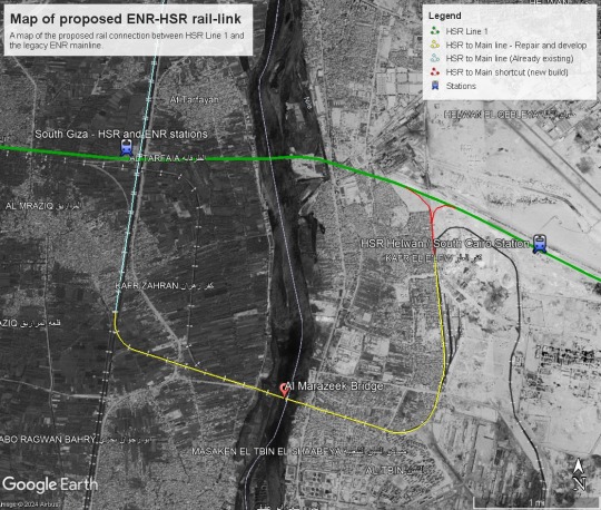

Pictures 22, 23, and 24: Maps of proposed ENR-HSR Rail-link in the Greater Cairo region (Source: Own work using Google Earth).
2-b- the future-proof yet costlier option: electrify the gap from South Cairo/Helwan to Cairo central station. This would guarantee that all of the HSR trains can enter Central Cairo and would not require the Rail Class 802 units.
How did I calculate the costs:
It’s not entirely clear how much 1 km of electrified rail costs in Egypt. However, the entire 660 km of rails, signaling systems, compensations paid, stations and the train sets cost about 4.5 billion euros.
Now if we make the very prejudiced assumption - based on the study “Economic investigation for building a high-speed rail in developing countries: The case of Egypt” by Belal et. al 2020 - that the actual Infrastructure (rails and overhead wiring etc) costs only 15% of the 4.5 billion, that means, (4.5 billion € /660 km+all stations and facilities)*0.15= 1 million € per km of rails and overhead wires.
Also, assuming that the rehabilitation of existing railways costs a third of placing a completely new set of tracks, that means rehabilitation of rails costs 333 thousand euros per km. Let’s assume that the electrification costs of existing rails costs also 333 k.
Cost of 2-A plan:
1 km of new rails: 1 million euros
7 km of rehabilitation of the existing tracks: 330 thousand x 7 km = 2.3 million Euros
Total: 3.3 million euros
Percentage of this plan to the main project expenses: 0.07 percent of the total project cost (i.e. peanuts!).
Cost of 2-B plan:
1 km of new rails: 700 thousand euros
7 km of rehabilitation of the existing tracks: 300 thousand x 7 km = 2.1 million Euros
Total: 2.8 million euros
Percentage of this plan to the main project expenses: 0.06 percent of the total project cost (i.e. peanuts!).
Cost of 2-B plan:
1 km of new rails: 700 thousand euros
7 km of rehabilitation and electrifying existing tracks: 666 thousand euros 00x 7 km = 4.6 million Euros
38 km of electrifying existing tracks (from Marazeek to Cairo Central) = 12.6 million Euros.
Total: 17.2 million euros
Percentage of this plan to the main project expenses: 0.38% of total project cost, (a bag of salted peanuts in comparison!).
My opinion on this: I think for the time being, and given the financial crisis, it is much better to resort to the EDMUs that are similar to the UK’s Great Western Rail Class 802. These were designed to run on British railways which are not only of similar age and design but were actually built by British Engineers in the 1880s. Instead of reinventing the wheel, we can simply adopt it as a literal stop-gap solution until we have more money to electrify the ENR legacy mainline.
Besides, a great chunk of the ENR network will not be electrified anytime soon. Therefore, if the section between South Cairo/Helwan and Central Cairo proves to be of popular demand and electrification then becomes due, these EDMU units can still be deployed on many other sections across Egypt’s rail network, including from Ain ElSokhna to Suez, bridging HSR and ENR networks from the Eastern end of the line.
3- Build slip paths and branch-offs
Several slip paths and branches need to be built urgently to connect crucial infrastructure and provide real accessible and intermodal transport.
3-a- Borg ElARab airport slip path and train station.

Pictures 24 and 25: Maps of proposed Borg ElArab Airport - HSR Line 1 Rail-link (Source: Own work using Google Earth).
This is an obvious slip path and absolutely necessary.
Cost:
6.5 km of new rails = 4.5 million euros
1 new station (Between T1 and the new T2 passenger buildings at Borg ElArab International Airport): 1 million euros
Total: 5.5 million euros.
3b- Sphinx Airport branch off
While Smart Village and Abu Rawash Industrial area are a tad too far for a slip path, a branch off may do the job (to connect the airport, and possibly a light rail from airport to Smart village and Abu Rawash in the future) with a main train terminus station adjacent to the Sphinx Airport passenger terminal. It would connect HSR 1 with Sphinx Airport and allow for this mix of routes to take place:
Sphinx Airport - Central Cairo
Sphinx Airport - Borg ElArab airport - this would put these airports on the map of the budget airline transit industry, with passengers changing between airports using the HSR Line 1.
Sphinx Airport - West Alex
Sphinx Airport - North Coast and Matrouh
Sphinx Airport - New Cairo
Sphinx Airport - New Capital
Sphinx Airport - Ain Sokhna
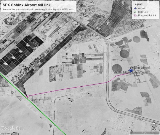

Pictures 26 and 27: Maps of proposed Sphinx Airport - HSR Line 1 Rail-link (Source: Own work using Google Earth).
4- New Cairo First mile/Last mile?
Given the massive distance of the station from the city, and the social and economic importance of New Cairo, the only long term solution is to connect the HSR to New Cairo and its passenger volume potential, is by a rail branch off.
However, some form of LRT or Sbahn-styletrain connecting the Mohamed Naguib station to New Cairo’s different districts can help establish the mobility demand at a lower budget, and that would financially support a future branch off into New Cairo.

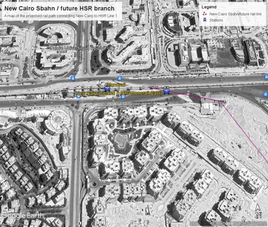
Pictures 28 and 29: Maps of proposed Mohamed Nagiub to New Cairo ‘sbahn’ link / future HSR branch (Source: Own work using Google Earth).
This may be true at Ain ElSokhna too: Where an LRT or coastal suburban line can help connect the small towns and resorts along the shore to the station.
Conclusion
The logic of these suggestions and ideas proposed here revolves around 5 key concepts:
1- Accessiblity and Intermodality:
If we want as many people as possible to benefit from the service and pay for HSR (to cover the costs and make net revenue), we need to make it as accessible and intermodal as possible. You need to reduce the number of changes at important stops (such as airports, metro/monorail/major bus stations, and terminals) by having direct connections to them. A bus from the HSR station to the nearest airport or metro station just won’t cut it for many people. Also, people traveling with luggage do not want to change more than a handful of times if ever.
2- Prioritize service to Urban areas:
Major urban agglomerations must always have their own train stops, and depending on their location and Population size, they must also be served by all types of trains (express, regional, and suburban). People living in well-established urban areas are less likely to drive to a stop more than 2 km away from the urban core. This is especially the case if the total journey time on existing trains eventually adds up to the same journey time expected, leading to no savings in time or fuel/trip costs.
3- Encourage Transit oriented development:
Whenever possible, if we have a stop next to empty undeveloped land, we should encourage the building of transit-oriented developments. These will become very much-needed and sought-after Housing units and will make maximum use of the existing railway and its adjacent services.
4- Closing the gap between the legacy and HSR systems:
In places where there is a phased transition or the construction of new railway systems, there must be a goal to close the gap between the two systems by finding ways to integrate them. This is particularly true between the HSR and ENR systems. If they both become integrated, it increases the resiliency of both systems and will help with the electrification of all the non-HSR railways, making it easier to provide new route combinations and have fewer transfers and modal changes due to the gap between electrified and non-electrified train routes.
5- Stations aren’t the end of the journeys:
If a station is not within a dense urban agglomeration, LRT or suburban rail services can help connect the station with its neighboring towns or villages.
I would even argue that in the medium and long run, it is in the interest of Siemens and DB to build these extensions and branches. In their paper, Belal et. al (2020) included a very important piece of advice to DB and Siemens:
“There is no doubt that the passenger flow (PF) on HSR is a crucial factor shown on ticket revenue. It has a direct impact on the total income of the project. Therefore, it has a significant role in project feasibility.” (page 1006)
As people in Egypt start getting to know the HSR network, folks regularly traveling between Cairo and Alexandria, for example, may begin to prefer traveling via the HSR network, if they know that they can get on an express train in Cairo Central and get to Alexandria or Borg ElArab Airport in one go, and much faster than they were used to traveling on the legacy line, that would make the HSR network a game changer of mobility in Egypt; and perhaps also benefit DB on the long run too.
Links:
#cairo#high speed rail#egypt#siemens#deutsche bahn#mobility#trains#British Rail#german railway#alexandria#Marsa Matrouh#Ain Sokhna#Red2Med#red sea#mediterranean sea
1 note
·
View note

Text

The SUbMonitor's Unofficial Amman BRT map!
After trying out and navigating the Amman BRT system myself, I noticed there are no official Schematic maps showing the BRT's stops and directions. Therefore, I decided to put my skills in use and make an unofficial map for Amman's BRT system!
If you have any questions or feedback, please leave a comment or send us a message.
In the coming weeks, there will be a follow up post talking about my experience on the Amman BRT, my thoughts on it and recommendations for the future.
P.S: I would like to thank my dear friend and colleague, Hazem Zureiqat, for his insights and for his tips on how to navigate the BRT system as a new user. I thank him a lot for his advice and also recommend that you have a look at his article on this topic:
(in Arabic) https://www.7iber.com/environment-urban/making-bus-rapid-transit-work/
(in English) https://web.archive.org/web/20160630105729/http://www.venturemagazine.me/2016/06/making-brt-work/
0 notes
Text
Buseet, a promising mobility startup that got tossed under the (micro)bus of a giant competitor, or a textbook example of gross fleet mismanagement?

Caption: Buseet had a lot of promising services, making it a comfier ride to a regular microbus. Credit: Buseet Egypt Instagram page.
Full disclosure: Several attempts were made to reach out to Amr ElSawy - CEO of Buseet Egypt - through various channels of communication. At some point, we even agreed to have a zoom chat after last Eid. However Eid came and went by without any response or concrete answer from ElSawy.
Not wanting to keep this story away from the readers’ eyes for too long, I have decided to move ahead and publish this article, and will post an update if ElSawy or any representative on his behalf sends in a comment or statement in response to this article.
Writing about public transport projects in Egypt is not particularly a happy task. On many occasions one feels the need to applaud the fact that a metro or high speed rail is being built in cities dominated by car traffic. However, the devil lies in the details and the little fine print on where the stations are placed and intermodal integration etc.
However, writing this article about Buseet has been one of the most depressing acts of writing about transit and mobility in Egypt.
In 2016, after Buseet’s buses began to sprawl the city’s streets, many spectators particularly in the startup scene speculated that it would end up being one of the most promising startups in the MENA region. Now, according to multiple sources both in the transport and startups sectors, the CEO and founder Amr El-Sawy is preparing to dissolve the company and has already moved to Dubai on a new endeavor. As mentioned earlier, multiple attempts were made to seek comments or any statements from the former CEO Buseet, in vain.
Where did things go wrong?
Multiple sources, who asked their identities to be withheld, said that Buseet simply did not have enough passengers using their buses on a regular basis, which meant they could not cover the costs of their daily operations, despite the growing demand for the service Buseet provided.
One source, who was close to multiple employees and the founder of the company, said that Buseet had a high rate of running costs mainly because they neither owned their microbuses, nor did they actually hire full time drivers to operate them. Buseet’s business model relied on making use of existing tourist bus companies that were experiencing a slump of demand due to the decline of tourism following the events of January 25th 2011 and onwards, and outsourcing the operations to them.
While initially lucrative, this left them vulnerable to the fluctuations of market rates of microbus rentals, particularly that the Tourism industry in Egypt picked up and demand on tourist bus companies rose back up in 2018, jeopardizing Buseet’s operations.
Another factor that led to Buseet’s decline was the lack of fleet and human power to achieve a sufficient enough frequency that would then incentivize passengers to change their daily commuting habits, and pick Buseet as their daily commute. In addition, Buseet - despite not having a significant fleet - cast a wide web of routes across Greater Cairo, leading them to stretch their availability slim by having a very limited schedule, offering on many routes only 2 trips a day.
While Swvl - Buseet’s arch nemesis - had a gigantic fund, and therefore could afford to lose a ton loads of money while continuing to gain a consumer base, Buseet had not been able to raise more than 3.7 million USD in 6 rounds of funding (Crunchbase - a, n.D). Swvl on the other hand got 254 million USD in only 8 rounds of funding (Crunchbase - b, n.D). Such an amount is not insignificant, yet Buseet seems to have gone around spending the amount running empty microbuses that people did not have incentives to ride due to lack of flexible scheduling and frequency.
Caption: Mohamed Neamatalla’s post on Buseet’s facebook wall, thanking them for their qualitatively much better service and customer service than Swvl, its main competitor.
Credit: Mohamed Neamatalla - Facebook, 2020.
The lack of a reliable fleet, coupled with an overambitious yet under-staffed network of routes, led to few passengers picking up rides with Buseet, despite it providing a qualitatively better service than its main competitor, Swvl. For instance, Swvl prioritized more profitable journeys over less popular ones, leading them to sporadically canceling trips booked by customers and simply refunding them or giving them credit on their account. On the other hand, Buseet honored its routes, even if only there was 1 person per journey. That racked up the costs of operations and ate away at Buseet’s already fragile finances.

Caption: Screen shot of Buseet's instagram account January 25, 2017, showing a buseet route going from ElSherouk, Madinity, Rehab to Mohandiseen. Only two trips a day, one leaving ElSherouk heading to Mohandiseen in the morning, and another trip returning from Mohandiseen in the afternoon.
Credit: Buseet Egypt Instagram account - January 2017.
Ironically, honoring routes and journeys would have been the more sound policy in comparison to what Swvl does. However, Buseet did not have the money to keep these journeys going, nor did they consolidate their minimal fleet on a single route/a handful of routes to achieve maximum frequency and increase the ridership of their buses.
Having a somewhat expensive price per journey in comparison to a regular microbus, without the frequency of a regular microbus route might have been the most lethal element to Buseet’s operations. Consolidating its fleet operations on to 1 or 2 routes where no other competition operates and running a much more frequent service would have generated the ridership they needed to be able to not only stay afloat, but also gain a wider customer base that would support them and use their services in any future expansion of Buseet’s network.

Caption: A rare example of a Buseet route with more than 2 trips a day: Sheikh Zayed-6th of October city to Maadi. 6 trips a day. Focusing more fleet and service on such routes, and reducing costs by making sure the route overall covers its costs, by using revenue from crowded trips to cover costs of less crowded trips could have helped Buseet stay afloat.
Credit: Buseet Egypt Instagram account - January 2017.
Not to mention that Buseet banked on so called Business to Business (B2B) operations, which for a while brought in some desperately needed cash, up until COVID 19 hit and caused many of these companies to ask their employees to work from home, and therefore canceling their contracts with Buseet. Another element that is related and has had an impact on Buseet, is the lack of secure cash flow for the business, and having to chase client companies to pay their dues in time. That made Buseet always strapped for cash.
And while Swvl might have survived (for now) due to its unfathomable ability to fundraise and even having enlisted on the NASDAQ index (Wamda News 2022), Buseet lost this battle not only because it kept its eyes on the (unsustainable) operations of their main competitor, but also it put all its eggs in the basket of B2B operations, which got blown away by the COVID 19 pandemic.
The fatal blow was their inability to read the mobility situation of Greater Cairo, or learn from how regular microbus routes have actually managed to achieve such great success (in a much more hostile environment in comparison to what Buseet had on its side). Frequency and a wise fleet management could have been the saving grace of Buseet, but the lack of them thereof has led to their demise.
Unfortunately this is a shame and a great loss to the mobility mix of Greater Cairo. It seems like so far, CTA buses and the Microbus routes of Cairo will remain the most robust mode of transit to achieve the missing first mile and last mile links to the metro network, alongside some of Swvl’s and Uber’s vehicles. In fact, Swvl has been able to secure a contract with the Ministry of Transport, to provide “first mile/last mile” services to and from the planned Cairo BRT station (Zawya 2023). Will Swvl be able to survive and stay afloat in a sphere that is narrowing by the day, and consolidating into other mega startups like Uber? This is a question for another post.
Related links and sources:
Instagram. (n.d.). Buseet Egypt. https://www.instagram.com/buseeteg/
Facebook. (n.d.). Buseet. Buseet Egypt. https://www.facebook.com/buseeteg
Farid, D. (n.d.). Is Egypt finally ready for ride-sharing?. Wamda. https://www.wamda.com/memakersge/2017/04/egypt-finally-ready-for-ride-sharing
Crunchbase. Buseet - funding, financials, valuation & investors. Crunchbase. (n.d.-a). https://www.crunchbase.com/organization/buseet/company_financials
Crunchbase. SWVL - funding, financials, valuation & investors. Crunchbase. (n.d.-b). https://www.crunchbase.com/organization/swvl/company_financials
Wamda News. SWVL debuts on Nasdaq, sets initial offer price at $9.95 per share. Wamda. (2022, March 31). https://www.wamda.com/2022/03/swvl-debut-nasdaq-sets-initial-offer-price-10
Zawya. (2023, June 8). SWVL obtains 1st license in Egypt to operate Smart Transport. ZAWYA. https://www.zawya.com/en/economy/north-africa/swvl-obtains-1st-license-in-egypt-to-operate-smart-transport-fu42kl2s
0 notes
Text
Cairo Airports metro links: Can they, finally, be completed?
Credit: M. ElKhateeb 2020
Perhaps you’re wondering, “Did I just read the title correctly? What do you mean by ‘Cairo Airports’ (with an “s” at the end)?”. Well, friends and colleagues, Cairo is no longer served by a single commercial airline hub. Cairo now has -gasp- 3 civilian-use airports, not counting the airfields and private airstrips/training airports (such as the 6th of October city airport, etc). Officially, Greater Cairo has Cairo International Airport, Sphinx International Airport, and Capital (International?) Airport.
You might say, but Sphinx International Airport is in Giza Governorate, and the Capital Airport is at the farthest eastern edge of Cairo Governorate, bordering the edges of the Suez Governorate. That may be true. However, both airports are, in fact, at the very edges of Greater Cairo. The Greater Cairo region is a semi-official entity that includes the Cairo Governorate and parts of Giza, Qaluibia, ElSharkia Governorates, and the "new administrative capital". This isn’t only a classification used by researchers and urbanist nerds like myself, it is also classified as such according to the Egyptian Local Governance law (EGY-SIS n.d).
A little bit of background…
Today marks the three year anniversary since the Cairo Airport metrolink was officially cancelled by the NAT, National Authority for Tunnels (Habashi 2020). I already made a video about why Cairo Airport is so difficult to reach by public transport, and in it I mention the transport situation at Cairo Airport.
Yet three years after the Heliopolis-Airport extension has been cancelled, we find ourselves in an interesting situation. There are yet to be any updates regarding the Adly Mansour-Cairo Airport shuttle bus service (Habashi 2021), nor does Cairo Airport have a designated BRT station, as of writing these words (see figure 1). Had the project continued as planned, we could have already inaugurated the Cairo Airport metro station, particularly given how the 3rd Line (aka Green line) is almost complete.
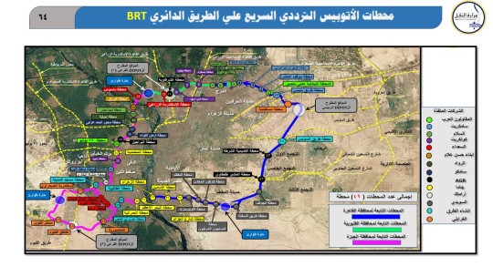
Figure 1: Map published by the Egyptian Ministry of Transport, showing the proposed sections of the Cairo Ringroad Bus Rapid Transit (BRT) project. n.d
Not only is there no high frequency mode of public transport, other than some of the commuter services run by Cairo Transport Authority (CTA), we also have two new airports that are yet to have any public transport connected directly to their terminals or within their premises.
So, how did we get here?
Sphinx Airport was a response to the need to have a western air hub for Cairo and Giza, that could a) relieve Cairo Airport, particularly during peak tourist seasons, and b) actually serve the folks living on the west side of the Nile in Greater Cairo (Varley 2023). Cairo International Airport is 27 km away from Giza square and 74 km away from the 6th of October city by road.

Figure 2: Distance by road from Cairo International to Giza Square. Credit: Screenshot from Google Maps.
And, needless to say, the New Capital airport was built alongside what is known as the new administrative capital. So, yeah, Cairo now has 3 airports.This begs the question: Are these airports a) connected to the metro/lrt/rail network? b) can they be somehow connected directly to each other?
These two questions can be answered in two folds:
Yes, Cairo International and Sphinx International can very easily be connected to the metro network. In fact, Cairo Airport came very close to having its very own 3rd line metro station, until it was "put on hold" due to "cost considerations". Sigh.
And yes, Cairo International and Sphinx International once connected to the 3rd line metro, would have a direct high-density rail connection, making them a super air hub (that is much more doable and reasonable than the Gatwick-Heathrow link proposals - see Jay Foreman’s video here: https://youtu.be/KXmpdJO9UOc).
As for connecting the Capital airport to its sibling ports, it gets a little bit trickier. The Capital airport technically has its own station on the LRT line heading to the new administrative capital. However, the station is quite far from the airport terminal. Making it beyond walking distances for commuters and passengers.
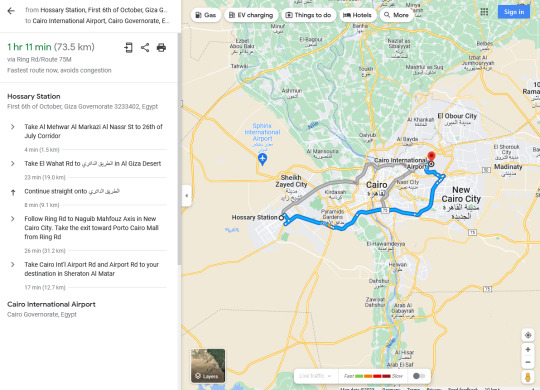
Figure 3: Distance by road from Hossary Square - 6th of October city to Cairo International. Credit: Screenshot from Google Maps.
Yet, given that this area is yet to be densely populated and there is PLENTY of free and empty land around, it will be very easy to link up the airport to the station, perhaps even using a simple electric tram running along the street connecting the airport to the station.
This would mean however, that anyone transferring from Cairo International or Sphinx International would have to take the metro to Adly Mansour station, change there to the LRT, then get off at the Capital Airport train station and take the tram to the airport. Needless to say, this is still doable and perhaps even not as expensive as people might think.
What can be done?
For starters, the Heliopolis Metro station was built with the foresight that one day an airport connection will be extended out of the station. The original plan, though, included tunnelling under restricted areas and into Masaken Sheraton, making the plan pricey, leading to its unfortunate cancellation (Habashi 2020). However, if we amend this plan to find a much more direct route to the airport, with the possibility of turning a section of this track into an overground route, this will slash the costs and reduce the construction time by half at the very least. Not to mention that many local private construction companies such as Orascom, and public companies such as the Arab Contractors, have built up the experience to build overground metro links (having completed the overground sections of Line 3). Hence this will probably be a piece of cake for these companies.
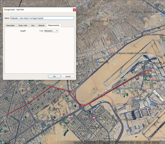
Figure 4: Proposed low cost metro extension from Heliopolis to Cairo International Airport. Proposed route skips going through Masaken Sheraton, and instead follows along the old Airport road, terminating at Cairo Airport’s Airmall, right next to Terminal 1 and connecting to other terminals via the automated people mover. It also passes by the main Airport administrative buildings and Terminal 1-Hall4, hence providing metro access to hundreds if not thousands of employees and airline staff. Credit: Screenshot from Google Earth.

Figure 5: A map previously published by the National Authority for Tunnels (NAT), that includes a proposed detour into Masaken Sheraton, and terminating at the west side of Terminal 3. Credit: NAT 2017
As for the Sphinx airport, despite the massive distance from the Line 3 terminus at Rod ElFarag, the path from the metro station to the airport terminal is surprisingly easy and wide open. Quite literally. Since the most difficult part of making this section of this route has been completed, building through some of the densest parts of Imbaba, Giza, the proposed route from the station to the airport would simply use the embankment or the Rod Elfarag axis all the way to the airport. There would only be a need for a few bridges here and there, which we all know are built far too easily in Cairo. Basically, the path is literally calling for it to be used for the metro construction. It has minimal curves, and not that many intersections that could make any construction work expensive.
Also aside from some emergency platforms along the way, you don't need to build that many stations between the Rod ElFarag Station and the Sphinx airport, cutting the costs down even further!
Figure 6: Proposed low cost metro extension from Rod ElFarag to Sphinx Airport. Credit: Screenshot from Google Earth.
Do we really need the Airport metro-links?
The short answer is: Yes, of course!
What would be the benefit of such links? They would be huge! First, this would put Greater Cairo firmly in the airport transit industry, catching up to its sibling hubs in the Arab World/middle east such as Dubai and Doha. Second, they would also serve thousands of government and airline employees, including customs officers, airport staff, and other staff working in industries associated with the airport industry.
Figure 7: Platform at Airport Terminal 3 Red Line Dubai Metro station, Dubai International Airport, Dubai, UAE, for trains to Jebel Ali (since June 2015 UAE Exchange) station, on 4 April 2012. Credit: Cornelius Kibelka - Wikimedia Commons - URL https://commons.wikimedia.org/wiki/File:Metro_Dubai_%287069089103%29.jpg
These links would also actually help relieve Cairo airport by making Sphinx a sibling airport that can take up some of the extra charter and seasonal flights, while still giving the passengers the possibility to connect to other flights at the other airport much more easily.
Needless to say, they would also boost all kinds of transit tourism and one-day tourism, of folks who were either domestically visiting other parts of Egypt like Sharm ElSheikh or Aswan, and instead of just connecting through Cairo for their flights, they can also make use of any layover time to visit the city, pass by the Grand Egyptian museum or the Giza pyramids (both of which will very soon have their very own metro stations on line 4), or simply visit downtown Cairo for its urban and food attractions etc.
Building these extensions would provide some of the remaining missing links Cairo has in its overall multi-modal transport plan and would, with a very limited construction plan, put Cairo back firmly into the urban tourism list and provide tourists, visitors, and residents alike a transit alternative that would help them move around during Cairo's everlasting traffic rush hours without the frustrations of being stuck in Taxi on the 6th of October bridge, anxiously hoping they will make it to their flight in time.
And in all cases, before anyone jumps at me saying "But what about taxis and limousines going to the airport?" To them I say there will always be tourists and visitors who must take a taxi because they are a) a family, b) have heavy luggage, c) have the time, want to avoid the metro crowds, and can afford to take an uber/taxi/limousine to the airport. In fact, with an increased number of passengers, and with Cairo's airports being more attractive for all kinds of airlines, the number of folks who will use Uber/taxis and limousines will rise, because there will simply be higher capacities in at the airports leading to more folks coming into town and dropping by for a visit.
Figure 8: Cairo International Airport, Terminal 3 at the shuttle bus stop. Credit: Alensha - Wikimedia Commons - URL: https://commons.wikimedia.org/wiki/File:Cairo_Airport_Terminal_3.jpg
References
Government of Egypt State Information Service (EGY-SIS). (n.d.). Local Administration (in Egypt). State Information Service. https://www.sis.gov.eg/section/275/2565?lang=en-us
Habashi, R. (2020, July 8). National Authority for Tunnels cancels Cairo Airport Metro extension, replaces with a “shuttle bus.” Youm7.com. https://www.youm7.com/story/2020/7/8/%D8%A7%D9%84%D9%82%D9%88%D9%85%D9%8A%D8%A9-%D9%84%D9%84%D8%A3%D9%86%D9%81%D8%A7%D9%82-%D8%AA%D9%82%D8%B1%D8%B1-%D8%A5%D9%84%D8%BA%D8%A7%D8%A1-%D9%88%D8%B5%D9%84%D8%A9-%D9%85%D8%AA%D8%B1%D9%88-%D9%85%D8%B7%D8%A7%D8%B1-%D8%A7%D9%84%D9%82%D8%A7%D9%87%D8%B1%D8%A9-%D9%88%D8%AA%D8%B3%D8%AA%D8%A8%D8%AF%D9%84%D9%87-%D8%A8%D9%80/4866381
Habashi, R. (2021, March 8). Plans to operate eBuses between Adly Mansour and Cairo Airport. Dedicated 3 km path to connect Cairo airport with NAT LRT. At cost of 280 mil USD. Youm7.com. https://www.youm7.com/story/2021/3/8/%D8%AE%D8%B7%D8%B7-%D8%AA%D8%B4%D8%BA%D9%8A%D9%84-%D8%AE%D8%B7-%D8%A3%D8%AA%D9%88%D8%A8%D9%8A%D8%B3%D8%A7%D8%AA-%D9%83%D9%87%D8%B1%D8%A8%D8%A7%D8%A6%D9%8A%D8%A9-%D8%AA%D8%B1%D8%A8%D8%B7-%D9%85%D8%AD%D8%B7%D8%A9-%D9%85%D8%AA%D8%B1%D9%88-%D8%B9%D8%AF%D9%84%D9%89-%D9%85%D9%86%D8%B5%D9%88%D8%B1/5236430
Varley, L. (2023, May 29). Flynas to launch direct flights to Sphinx International Airport. AviationSource News. https://aviationsourcenews.com/airline/flynas-to-launch-direct-flights-to-sphinx-international-airport/
0 notes
Text
TUMI 2023 Report. Feminist voices in Transport: Transport planning is not gender neutral!
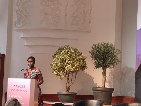
It was such an honor to be invited to the latest iteration of the Transformative Urban Mobility Initiative’s (TUMI) “Women Mobilize Women” conference held at the Leipziger Kongresshalle on May 23rd, 2023. For the first time after the COVID-19 pandemic, I did have the chance to meet up once again with my colleagues and friends in the field of Sustainable Mobility and to get to meet new colleagues from all over the globe.
Out of dozens if not hundreds of international conferences tackling the issues of Sustainable Mobility and the related aspects of urbanity, TUMI’s conference provides a rare opportunity to meet Women leaders and researchers in the field of mobility. It also provides a much-needed platform for like-minded folks and supporters of making the case for gender-sensitive mobility solutions and research, especially in the post-COVID-19 world.
To reiterate the words of Christine Toetzke, the director general for the departments of Asia; South Eastern and Eastern Europe; Middle East, and Latin America at the German Ministry for International Cooperation (BMZ), we need to keep on restating the case for “why we need feminist voices for gender transformative planning”. We need to, according to Toetzke, try to explain all over again why feminism is important, particularly to urban transport and city planners. It is important we are committed to enabling all people to participate in all facets of life regardless of gender/clan/race and so on.
Christine Toetzke - director general for the departments of Asia; South Eastern and Eastern Europe; Middle East and Latin America at the German Ministry for International Cooperation (BMZ) - speaking during the Confernece.
These words and sentiments were not exclusive to Toetzke, but in fact, were a shared sentiment across the board. Robin Chase, co-founder of Zipcar and Tucows, about her story as a mum in the US, having to figure out a way to have access to mobility despite the sprawl and lack of public transport, leading to the establishment of Zipcar. Her startup led the way for other startups such as Blabla Car and other care-sharing startups across the world.
This was shared by the other panelists, including Yasmine Al Moghrabi who shared her own personal experiences with regard to road safety and the loss of life that we seem to have normalized car crash and collisions casualties, and deaths on the road. This then shifted the focus onto the contributions of Cyrpine Odada - the executive director of Critical Mass Nairobi, Kenya - and Keisha Mayuga - the director of AltMobility, Philippines - which focused on encouraging and making active mobility modes such as cycling safe and accessible to all. Odada specifically talked about her efforts promoting safe cycling by forming “bike trains” or gathering points and routes where cyclists can cycle together in shuttles to work/school etc and make use of their numbers to make their daily cycling commute safe for all of its participants.
Afterward, Andrea San Gil Leon - from the Global Network for Popular Transportation, Costa Rica - talked about breaking the mold of the so-called “informal transit” or “para-transit”, which their core are terms that carry an inherent amount of shaming and euro-centric (if not colonial) projection over modes of transport that have thrived and worked for decades, providing the communities they serve with essential and reliable mobility, albeit not fancy-looking or potentially comfortable as other modes of mass transit. San Gil Leon calls for replacing the word informal with a much more honest and representative term, Popular transport.
As the name suggests, these are modes of transit that may not fit in the so-called “official” transit, such as Government runs buses or trams/metro, etc. However, they do, honestly, represent what kind of transit it is: a popular mode that communities have come to rely on, especially women and other people who have caretaking.
Such popular transport services, while they may form profound obstacles to the traditional gender insensitive planning (aka gender neutral planning), they in fact fill a needed gap in the absence of formal, regulated services for women and other marginalized groups.
Later that day, one of the breakout sessions “Importance of Gender Responsiveness for Climate and Social Resilience in Transport” focused on how climate change increases the vulnerability of transport and mobility systems. Such new challenges posed higher risks and greater burdens on women and marginalized groups across the world. A discussion and group brainstorming took place examining the linkages between gender, transport, climate change adaptation, and socioeconomic resilience of transport systems.
One of the most profound keynote speeches of the day was Senator Crystal Asige’s words on the multiple layers of disadvantages facing BIPOC (Black, Indigenous, People of Color) with disabilities, particularly women with disabilities. Speaking of her very own experience of navigating the public space both in Kenya, the UK, and elsewhere while black and having glaucoma. Her words helped shed light on the intersectionalities of disability and gender and were an inspiration for the closing panel, which included speakers like Dr. Amani Abou-Zeid from the African Union Commission, Chiara Corazza - the French Representative of G20 EMPOWER initiative and a member of the G7 Gender Equality Advisory Council, Maruxa Cardama from the SLOCAT partnership on Sustainable Low Carbon Transport, Emmanuel John a Sustainable Urban Mobility Expert from Nigeria and CEO of Ochenuel Mobility, and Sonai Shah - founder of the Urban Catalysts and the executive director of C-SEC (Center for Sustainable and Equitable Cities).
Senator Crystal Asige from Kenya, during her keynote speech.
In the last panel discussion, the aforementioned wo/men leaders and experts of mobility spoke about the way forward and how to implement and finance Gender-Transformative measures in the Urban Transport sector. Dr. Abou-Zeid particularly spoke about Africa and the potential African nations have in leapfrogging and working out a more sustainable urban mobility reality in African cities and metropolises.
At the end of the day, Mary Crass - the head of Institutional Relations and summit at the International Transport Forum (at the OECD) - summarized some of the main findings from the “Women mobilize women 2023” conference. She stressed the importance of continuing to work together, grounding our reports in reality, the need to dig a little deeper into the OECD findings report, and announced that a gender toolkit is now online and available for experts and other stakeholders in the field.
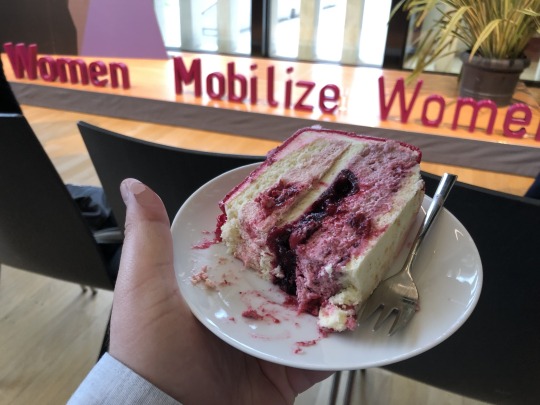
Caption of photo above: "Let's fight for equality AND have some cake!"
The organizers of the conference brought in cake for all the participants in celebration of TUMI's "Women Mobilize Women" initiative’s anniversary.
Caption of Photo below: Screenshot of the Global Network for Popular Transport website.

Main highlight: “Popular Transport” instead of “Informal Transport”.
Andrea San Gil Leon from the Global Network for Popular Transportation introduced a concept to the conference that I think is - from my personal experience of someone growing up in the Global South - essential and overlooked despite its importance and salience. San Gil Leon proposes that as researchers, leaders, and experts we should refrain from the word “informal” when describing non-government-owned modes of transport in the Global South such as Service cars, Microbuses, Tuktuks, and rickshaws. Instead, a more honest term that does not carry the same negative connotation would be “popular transport”. These modes of transit might suffer from a lot of issues and in some cases may be problematic in certain cities. However, they are only so, because of how they have been approached, studied, and in most cases made illegal or placed in a legal gray zone with the aim of removing them off the streets without necessarily providing any genuine reliable alternatives.
Approaching individual-owned and operated modes of public transport as a “popular” transport helps with its regulation, its development, and its integration into the modal split of systems. It also takes into account the households and families that rely on income-based from the operation of such vehicles, either directly as the families of the drivers/owners, the feeding industries of repair and maintenance, and those who rely on such popular transit to go to work, schools, markets and access government and social services.
For more information on this concept, and on the work of the Global Network for Popular Transportation, visit their website: https://www.populartransport.net/
#Tumi 2023#Feminism#Feminist voices#Transport#sustainable mobility#Equality#Disability rights#rights of BIPOC#the right to the city
0 notes
Photo

Photo Description: Screenshot of a twitter post showing 2 trucks/SUVs parked on a side walk along with a green lime e-scooter, somewhere in the United States. The twitter user @MattRuscigno comments (in a sarcastic tone): “So tired of these scooters blocking sidewalks). Also visible in the photo is a wide road with a parked row of cars next to the sidewalk.
One of the most annoying bad takes in the field of transit is the hyperfocus on how bad e-scooters are in terms of how they often end up blocking sidewalks. While it is true that, especially in the beginning, a lot of e-Scooters littered the sidewalks and were a cause of public nuisance, and in some cases outright dangerous for people with disabilities.
However, as the e-scooters apps get better at preventing such sidewalk littering, by forcing the user to take a photo of where they parked their e-scooter, the discussion that is not actually taking place is why scooters block sidewalks. Why are sidewalks so narrow that a single scooter can, and often does, effectively block a sidewalk, particularly for wheelchair users? Why don’t we say the same about massive SUVs and trucks parking on part or all of the sidewalk?
In my opinion, it boils down to normalizing giving the vast majority of the street or avenue space to cars, pushing pedestrians, cyclists, and scooter users to the edges of these roads. In fact, not only do cars end up taking the bulk of the road, they end up competing with the other streets users by parking right next to the narrow sidewalk (forming a hard border between the road and users) and at times parking on a section of the sidewalk, making it much harder for the rest of the people to navigate and use the sidewalks.
Source of twitter post: https://twitter.com/MattRuscigno/status/1661833236467830784
1 note
·
View note
Text
The (mighty) bus stop.
Like many things we overlook, the humble bus stop just around the corner from where you live might have a much mightier role than one might think. The role of bus stops, and specifically their infrastructure (if any), is usually underappreciated by many planners and residents alike. However, having a good bus stop can have a significant impact on the uptake of public transport by daily commuters. But what is a good bus stop?
On the superficial level, there is the actual look of the stop. The waiting area or bus shelter must be distinct and identifiable from other street furniture or sidewalk paving. It must stand out visually, and preferably also have facilities to aid people with visual impairments to find their way to the cusp of the bus stop, or “the platform”. Just like a train’s platform, the side of the bus stop facing buses must have some distinction or elevation to allow safe and easy embarkment/disembarkment by passengers.
The stop must have some sort of protection against the elements and bad weather, and a bench or chairs for waiting passengers. It should also have the basic amount of Passenger information: A) the name of the stop, B) the number and direction/Terminus of the route, C) an illustration or list of upcoming bus stops and a timetable, D) a map of the network, and preferable a map of the area near the stop, E) Fare and ticketing information, and F) information on how to contact the transit agency or retrieve more information online, etc.
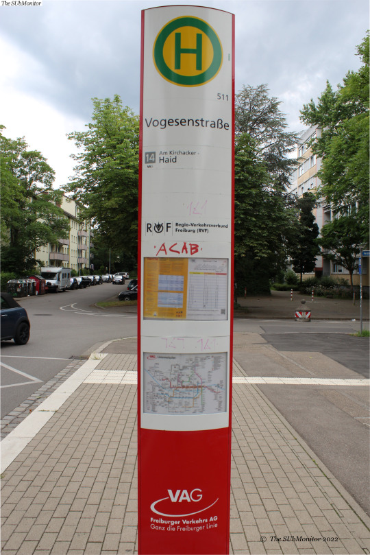
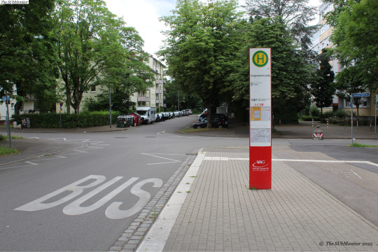
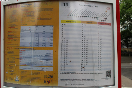
Here are two examples of bus stops: 1) the bus stop Vogesenstraße in Freiburg, Germany. While the bus stop lacks a shelter and a sitting area, it does check the mark on all of the other aspects, including a timetable and a map of the network. The lack of shelter or seats could be to reduce the chances of loitering and damage by graffiti since this is a small bus stop on a side street with a bus route that runs once an hour.
The assumption here is that people who need to use the bus will “know” when to head to the bus stop, and will not wait at the actual stop except for a few moments. This bus stop serves a low-frequency route (a variation of Line number 14) and while it provides a vital link to the central station (in the other direction/not visible in the photo), links to other parts of the city and the other more frequent modes of transit (such as the Tram), it remains an underutilized facility and many residents around here own private modes of transport (mostly bicycles, which is great of course, but also a lot of people own cars here too. Far too much, actually).

2) The second bus stop is a slightly busier stop called “Eschholstraße”, albeit serving essentially the same bus route. The two variations of Line 14, including the variation where the bus detours and goes to Vogessenstraße and other stops, stop here. The bus stop has a bus shelter, chairs, an information ticker giving real-time updates regarding the bus, information about the timetable, tariff zones, and a map of the network are also available.
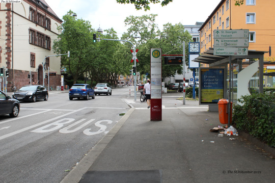
The bus stop is linked by a short sidewalk and a traffic light crossing to the nearby tram stop with the same name.

The tram stop is serviced by 4 tram lines with frequent service, which reaches up to a tram every 5 minutes during peak hours.


In the design of the bus route, the assumption might have been that residents can walk to the nearest tram stop (around 7 to 10 minutes walk), use their own modes of transit, or just plan ahead if they want to use the bus. The argument here isn’t that this bus stop particularly needs more services, but that how frequently the bus drives by has had an impact on neighborhood bus stops such as Vogessenstraße. Waiting for a bus that comes around only once or twice every hour will make fewer people want to rely on this service, which in turn would keep the number of passengers low and insinuate/and act as confirmation bias to planners that nobody wants to use this bus shelter and or stop, and hence maybe they should cut back services even more to save money and redirect the funds elsewhere. This is called repressed demand for mobility. It’s all the trips that could have been taken by bus, but are now car rides. There are a lot of people who walk and cycle here, yet ignoring the needs of other users is ableist, and makes the case for a significant number of families living here to think of having at least one car shared among them.
1 note
·
View note
Video
youtube
لقاء مع الباحث أحمد طارق الأحول بخصوص الدراجات الهوائية (العجل) في مصر
شكر جزيل للأحمد ومشروع "وصلة" لمشاركتهم في الحوار، لمزيد من المعلومات عن مشروع "وصلة" يمكنكم زيارة صفحتهم على الفسيبوك على الرابط:
https://www.facebook.com/waslaprojectegypt
ولمزيد من الفيديوهات والمقالات بخصوص قطاع النقل في مصر يمكنكم الإشتراك في القناة ومتابعة صفحتنا على الفيسبوك https://www.facebook.com/thesubmonitor
كما يمكنكم ايضا زيارة موقعنا على الرابط:
https://thesubmonitor.com
ويمكنكم التواصل معنا عن طريق صفحتنا على الفيسبوك او عن طريق البريد الإلكتروني [email protected]
شكرا لمتابعتكم لقناتنا وصفحتنا ولا تنسوى الضغط زر "اعجبني" اذا اعجبكم الفيديو وترك تعليق اسفل الفيديو اذا كان لديكم اي مقترحات أو افكار بخصوص ما ورد في الفيديو.
قائمة مصادر الروابط والصور الواردة في الفيديو:
Bossa Antigua by Kevin MacLead
Link: https://incompetech.filmmusic.io/song...
License: https://filmmusic.io/standard-License
Cairo tactical urbanism 2018
222 views
15 Apr 2019
https://www.youtube.com/watch?v=s8dJs...
إنشاء مسارات للدراجات بشوارع وسط البلد بعرض 1.70 متر.. تبدأ بشوارع محمد فريد وطلعت حرب وقصر النيل ومصطفى كامل و26 يوليو بطول 2 كيلومتر.. تنفيذ 30 محطة للدراجات بتكلفة 30 مليون جنيه ضمن مشروع "بسكلته"
الخميس، 14 نوفمبر 2019 07:30 م
كتب سيد الخلفاوى
https://www.youm7.com/Article/NewsPri...
Tabdeel تبديل
November 22, 2018
https://www.facebook.com/tabdeel4/pho...
Tabdeel تبديل
June 18, 2020
الأولوية للمشاة...
https://www.facebook.com/tabdeel4/pho...
مصر جميلة بالعجلة - الجزء الثانى
1,230 views
25 May 2020
https://www.youtube.com/watch?v=2FToZ...
UNDP Egypt - Shibin El Kom Bicycle lanes
https://www.facebook.com/UNDPEgypt/ph...
Uploader., Public domain, via Wikimedia Commons
https://commons.wikimedia.org/wiki/Fi...
Barrylb, Public domain, via Wikimedia Commons
https://commons.wikimedia.org/wiki/Fi...
The role of advertisements in the marketing of gated communities as a new Western suburban lifestyle: a case study of the Greater Cairo Region, Egypt | SpringerLink
https://link.springer.com/article/10....
Media Centre - Hyde Park
https://www.hydeparkdevelopments.com/...
Transformative Urban Mobility Initiative (TUMI), CC BY-SA 4.0 https://creativecommons.org/licenses/..., via Wikimedia Commons
https://commons.wikimedia.org/wiki/Fi...
موتوسيكل صيني بحاله ممتازة 150سي سي الماتور مفيهوش اي حاجه 2015
https://www.olx.com.eg/ad/150-2015-ID...
دراجة جديدة من٥ايام
https://www.olx.com.eg/ad/-IDcwAGj.html
دراجة كهربائية26 للبيع
https://www.olx.com.eg/ad/26-IDcxqAE....
مطالب بإنشاء خط سير بين أبنوب وأسيوط الجديدة.. وهذا تعليق المحافظ
https://weladelbalad.com/2019/09/17/%...
The S-Bahn in Berlin: On the Way with the Bike, During Spring
On the way with the S-Bahn: Train Station S-Bahn Charlottenburg, Enter with bike, In the train
Editor: S-Bahn Berlin GmbH
Author: J. Donath
https://sbahn.berlin/en/about-us/pres...
https://sbahn.berlin/en/about-us/pres...
الصفحة الرسمية لمترو القاهرة - الشركة المصرية لإدارة وتشغيل المترو
https://www.facebook.com/CairoMetropa...
ITDP Africa: Cairo tactical urbanism 2018
https://youtu.be/s8dJsiVUnl0
Carfree cities alliance
https://www.carfreealliance.org/
#cycling#bike lanes#infrastructure#New Cities#cairo#Assiyut#Sohag#6th of October city#Sheikh Zayed city#Egypt#berlin sbahn#Cairo Metro
1 note
·
View note
Text
The four horsemen of urban immobility: the case of paralysis in Greater Cairo. (An Op-Ed)
The four horsemen of urban immobility: the case of paralysis in Greater Cairo. (An Op-Ed)
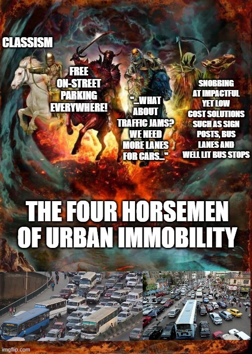
(Meme can be found on https://imgflip.com/i/5rsesh)
One might argue that there isn't a single solution for the urban mobility crisis in any city or metropolitan area. And while that is generally true, I argue that the regardless of the solutions proposed, we must account for and acknowledge some of the main pitfalls and logically fallacies both the lay persons and experts fall into when it comes to urban mobility issues in the global south: particularly something the megalomaniac size and intensity as the Greater Cairo Region.
In this article I list four main pitfalls and logical fallacies that have not only hindered our ability to find low-cost solutions to the issues of urban mobility in Cairo, but also are actively threatening to completely paralyze the city and exacerbate its problems to apocalyptic levels (hence the reference to the four horsemen).
1. Grandeur bias: Wasting low-cost opportunities to gradually fix public transport:
Massive investments in public transport is (in no question) a good thing for any city. Having that said, however, some policy makers and mid-level executive officials overlook the benefits of conducting small and gradual improvements to the public transport system; basically overlooking the low hanging fruit in favor for Grandeur projects.
A good example is fixing the Passenger information systems (both analog and digital) and making sure real-time scheduling data is available. Now with the proliferation of GPS tracking among the fleets of the CTA and CTA affiliate buses, its become much more easy to provide such service, and may only require hiring a small team of programmers (maybe even a single programmer) to write the code or make the piece of software that would connect the VDL (Vehicle Data Link), or the vehicle tracking software used by local bus operators, to Google Maps and other online map providers.
You may even take it a stretch further and hire a bunch of programmers or – young transit startup such as TfC- to write you a code or a city wide public transit app, or even just outsource the whole thing to a company like City Mapper. That would still be a cheap and low hanging fruit that would almost instantaneously improve the public transport experience in Cairo.
Another low-hanging fruit is maintaining a consistent and functioning yet bare-bones presence of bus stops along all the bus lines in Cairo. Several years ago, Cairo governorate attempted at doing such a thing and placed mass-produced concrete bus shelters all over Cairo (donated by a cement manufacturer). However, the locations of where these bus stops were was questionable and lacked the basics of a bus shelter (See images below): A banner or shield showing the name of the bus stop and the bus services that stop there, a functioning light source/light bulbs at night for safety purposes, and along major corridors an LED screen showing real-time transit data and delay/incident messages.


Newly installed bus shelters in different parts of Cairo. Last image is from Sherouk City, part of Greater Cairo. Note that lack of standard lighting fittings or any bus signage indicating name of the stop and buses operating on the route. The only sign that appears in the last image is not indicating the bus stop, rather a directional sign posts for passing vehicles. Sources: Masrawy, ElYoum ElSabea, ElAhram Daily.
With the advancement of technology, the costs of doing this are very low and attainable. In fact, many tuk-tuks and taxis decorate their vehicles with a ticker-like LED screens. So, it's not that expensive at all.
TukTuk with LED display and lights. Source: ArabNews/AP
2. Traffic-Oriented Disillusionment: Identifying the issue as a traffic congestion problem and not that the mobility system is fundamentally broken, and the heavy use of private vehicles is the real issue at hand.
While some people will absolutely need to use a car, either for certain trips or to fulfill all of their mobility needs, not all people need to use their car every single day. However, since the mobility system is fundamentally broken, people don't even recognize anymore that them having to drive everyday is the real problem and not the actual traffic congestion.
Therefore, traffic congestion is rather the symptom not the issue at hand.
However, lay persons, (many) city planners and experts continue to talk about the issue and frame it as a traffic congestion problem that needs to be resolved either through innovation (car-sharing apps/ride sharing apps) or in other heavy handed measures, by prioritizing Car traffic over all other forms of mobility such as CTA buses, micro-buses, trams, bicycles and even intercity coach buses. This, could be the argued, is a main logical fallacy that contributes to the rise of the other logical fallacies mentioned in this article.
The issue with this thinking is two-fold:
1- Cars, as a medium of transport, take a massive space on the road relative to the maximum number of passengers it can transport. In essence, cars are an inefficient mode of transport for everyday commuters within a metropolitan region. During the morning commute hours, private cars carry an average of 1.2 persons per vehicle (meaning most cars only have 1 person in them, while some others may have two passengers eg.) and take up an average 9.3 m2 of street space at any given time.
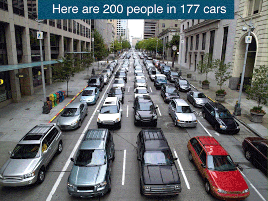
GIF showing 200 people in 177 cars, without cars, on bikes, on 3 buses and 1 Tram/LRT carriage. Source: imgur.
If an average private vehicle has a full capacity of 5 passengers per vehicle (assuming the commuters are car sharing in a single vehicle) that is a utilization (or density) of 0,54 persons/m2 of street space per vehicle (not counting in breaking distance or spaces between vehicles). In reality, only 1.7 passengers are in any given private vehicle on a weekday morning rush hour commute, translating to a lower density of 0.19 persons/m2. Multiply that by hundreds and thousands of cars within any stretch of road and you get the picture. That is simply an inefficient use of the very scarce space we have in cities.
3. Free Street Parking everywhere:
In a related manner, car owners think that free parking everywhere – or the expectation that any empty spot next to side walk/barrier/park/street median – and leave their vehicles parked for 95% of its life on public or shared property is fair game, which seems to be a notorious yet well-established fallacy. The Egyptian government recently attempted to place a law to regulate illegal parking attendants, that work off the streets by guiding car owners to park in tighter spots, or attempt to utilize all space available to park a vehicle. They also at times act as valets, and demand as such petty payments for their custom. Many car owners consider the illegal parking attendant (known in Egyptian Arabic as Sayis سايس) as a pest or the but of the joke.
However, what many of these car drivers conveniently overlook, is that the proliferation of these illegal parking attendants is due to their excessive ownership of private vehicles in such a dense city scape, compounded by the lack of state or city enforced parking regulations and pricing. As a result, an organic form of parking enforcement evolved and formed by the illegal parking attendants (albeit for an ulterior motive).
Hence, the state did do the right thing (and this is a statement I find myself seldom saying) in attempting to trying to reign in this madness and decide that on-street parking should not be a form of subsidy to car owners.
And thus the uproar by the 15% of families that own cars (this figure is based on the last National Census in 2017) in Cairo and the fact that it was for a brief moment taken seriously indicates that these car owners and their expectations contribute negatively to the well-being of Cairo and its residents overall (including the car owners themselves).
4. Classism:
Finally, one cannot proclaim an apocalyptic urban paralysis without mentioning the White Knight or urban mobility: Classism. City planners historically catered to car ownership by setting all kinds of regulations and standards that excluded people of color, minorities and blue collar workers.
In clearing buildings and green street medians of Heliopolis to build thoroughfares that only benefit outsiders to drive through with their space and gas guzzling private vehicle is the epitome of the privilige the comes with car ownership in Cairo.
In his essay "The right to the city", David Harvey talks about the attempts of the infamous Robert Moses, who (in his own words) "took a meat axe to Brooklyn", to reshape New York City in a fashion similar to what Haussmann did to Paris. Harvey wrote:
"Moses changed the scale of thinking about the urban process and through the system of (debt-financed) highways and infrastructural transformations, through suburbanization and through the total re-engineering, not just of the city but of the whole metropolitan region, he absorbed the surplus product and thereby helped resolve the capital surplus absorption problem. For this to happen, he needed to tap into new financial institutions and tax arrangements (subsidies to homeownership) that liberated the credit to debt-finance the urban expansion. This process, when taken nation-wide, as it was in all the major metropolitan centers of the United States (yet another transformation of scale), played a crucial role in the stabilization of global capitalism after World War II (this was a period when the US could afford to power the whole global non-communist economy through running trade deficits). The suburbanization of the United States was not merely a matter of new infrastructures. As happened in Second Empire Paris, it entailed a radical transformation in lifestyles and produced a whole new way of life in which new products from housing to refrigerators and air conditioners as well as two cars in the driveway and an enormous increase in the consumption of oil, all played their part in the absorption of the surplus. It also altered the political landscape as subsidized home ownership for the middle classes changed the focus of community action towards the defense of property values and individualized identities (turning the suburban vote towards conservative republicanism). In any case, it was argued, debt encumbered homeowners are less likely to go on strike. This project succeeded in absorbing the surplus and assuring social stability, albeit at the cost of hollowing out the central cities and generating a so-called urban crisis of revolts in many US central cities of impacted minorities (chiefly African-American) who were denied access to the new prosperity."
What happened to Cairo, especially its central and dense neighborhoods, is similar in a sense to what Haussmann and Robert Moses did to their cities. One cannot really tackle the issue only from a technocratic perspective without considering class, gender and race issues that befell urban planning processes and decisions. The Right to the sustainable urban mobility, i.e. the availability of public transit at an affordable rate and with decent services is essential to the right to the city, and not just a municipal or a technocratic matter.
List of URLs/Cited References:
Four Horsemen of the Apocalypse – Wikipedia, URL as on 26/10/2021: https://en.wikipedia.org/wiki/Four_Horsemen_of_the_Apocalypse
"Project Completion Report on Egypt - Greater Cairo Urban Development Project (Loan 2176-EGT)" – World Bank (1993), URL as on 26/10/2021: https://documents1.worldbank.org/curated/en/730531468235161396/pdf/multi-page.pdf
Cairo Transport Authority (CTA) – Wikipedia, URL as on 26/10/2021: https://en.wikipedia.org/wiki/Cairo_Transportation_Authority
Mwasalat Misr, URL as on 26/10/2021: https://www.mwasalatmisr.com/
Medium/Heavy Duty Truck Engines, Fuel & Computerized Management Systems - Sean Bennett (2020), URL as on 26/10/2021: https://books.google.de/books?id=SQfFDwAAQBAJ&pg=PA1181&lpg=PA1181&dq=VDL+remote+vehicle+tracking&source=bl&ots=9mcqKFFR4U&sig=ACfU3U3JPsG275xFLiqYxEbZVaHUS1-lsA&hl=en&sa=X&ved=2ahUKEwj6kKDB5OjzAhUKxBQKHZjDB_MQ6AF6BAgUEAM#v=onepage&q=VDL%20remote%20vehicle%20tracking&f=false
Transport for Cairo, URL as on 26/10/2021: https://transportforcairo.com/
Cairo Traffic Congestion Study : Final Report – World Bank (2013), URL as on 26/10/2021: https://openknowledge.worldbank.org/handle/10986/18735
Traffic congestion: the problem and how to deal with it, Edited by Alberto Bull, UN ECLAC (2003), URL as on 26/10/2021: https://repositorio.cepal.org/bitstream/handle/11362/37898/1/LCG2199P_en.pdf
La'nat AlTatwiir todared Sokan Madinet Nasr (Development Curse of Mustafa ElNahas St. follows the residents of Nasr City) - لعنة تطوير شارع «مصطفى النحاس» تطارد سكان مدينة نصر – ElWatan News (2019), URL as on 26/10/2021 https://www.elwatannews.com/news/details/4071623
Heliopolis Municipality Completely Removes Tram Line, Egypt – Environmental Justice Atlas, URL as on 26/10/2021: https://ejatlas.org/conflict/decommissioning-of-the-heliopolis-neighbourhood-tram-line1
How Cars Waste Space — In Six Simple Images, Streetsblog USA (2020), URL as on 26/10/2021: https://usa.streetsblog.org/2020/01/13/how-cars-waste-space-in-six-simple-images/
PERSONAL TRANSPORTATION FACTSHEET, Center for Sustainable Systems, University of Michigan (2021), https://css.umich.edu/factsheets/personal-transportation-factsheet
Today’s Cars Are Parked 95% of the Time, Fortune, URL as on 26/10/2021: https://fortune.com/2016/03/13/cars-parked-95-percent-of-time/
New vehicle parking regulations under assessment: Egypt's local development minister– URL as on 26/10/2021, Ahramonline (2021): https://english.ahram.org.eg/NewsContent/1/64/419687/Egypt/Politics-/New-vehicle-parking-regulations-under-assessment-E.aspx
Egypt's Sayes Law: 13 New Rules Set To Transform Parking In Cairo – NileFM (2018), URL as on 26/10/2021: https://nilefm.com/news/article/1288/13-new-requirements-and-regulations-for-el-sayes-to-work-in-egyptian-streets
Why Free parking is bad for everyone, Vox (2014), URL as on 26/10/2021: https://www.vox.com/2014/6/27/5849280/why-free-parking-is-bad-for-everyone
Cairo drivers see red over new parking charges, The National (2021), URL as on 26/10/2021: https://www.thenationalnews.com/mena/egypt/2021/08/25/cairo-drivers-see-red-over-new-parking-charges/
Egypt’s National Census 2017, URL as on 26/10/2021: https://www.enow.gov.eg/Report/EgyptCensus2017.pdf
The Right to the City, David Harvey (2008), URL as on 26/10/2021: https://purochioe.rrojasdatabank.info/harvey2008.pdf
0 notes
Photo

First of all, I would like to thank you all for all your support and patience in the past couple of months. I have had some back-to-back things I needed to attend to personally (including doctor visits/surgery for wisdom teeth extraction, but also happier stuff such as my wedding, and starting a new temporary job).
I apologize for not having made any posts or updates in the past couple of months.
Second, I have had a chance recently to pick up on some of the things that I had promised to follow up on in my last video. The good news is that I have now a better understanding of how the Cairo Airport public Airport-City buses work, and I would be happy to share some of that knowledge with you here.
The bad news, however, is that I won't be able to produce the Airport-to-City guide that I have promised earlier, or at least I won't be able to make it as accurately as possible and be some sort of a user guide at the same time.
After obtaining some of the Cairo Metro Geographic Information System (GIS) files needed from a good friend of mine, and using the Esri Shapefiles produced by Transport for Cairo and available as a creative commons online, I managed to map out the Cairo Airport bus and how they connect with the Cairo Metro.
I thought I was close to finishing the guide when I realized that much of the bus route information available online differs from what is actually operating on the ground. Also, there are a lot of anecdotes and asterixis that make the production of this guide even more complex and difficult. For example, Mowasalat Misr buses don't operate on weekends and during bank holidays. The Cairo Transit Authority buses on the other hand may or may not operate through until late evening. In addition, almost all of the bus routes operate on the main trunk of bus routes going from Cairo East (Heliopolis, Cairo Airport, Nasr City) to Central Cairo (specifically Abdelmoneim Riad). A few notable exceptions to that are the bus routes that continue further west to Zamalek and to Mohandiseen (in Giza), some other routes that pass by downtown Cairo but then turn north to enter Shubra. Also, 2 odd bus routes that stand out, as they don't go through downtown: such as bus 925 to Dawarn Shubra (which takes the Ismalia canal road passing by Aboud microbus terminal) and the 530 heading to goes to Qalyoub (which is not even in Cairo or Giza Governorates).
Mapping out the bus routes the way I did in the image attached, helped me get a good idea and a visualization of the kind of bus services that are currently connecting Cairo Airport, in light of the cancellation of Heliopolis Sq.-Cairo Airport underground metro link. It's not only that the Cairo Airport bus terminal is not located within easy walking distance to the terminals, but also that these buses mainly cater to a commuter base such as the employees working at the different facilities at the airport. Only very recently did Cairo Airport get public bus services that cater to solo travelers and passengers (basically those who are traveling light/with not extra bags).
And as mentioned in my video earlier, it is only likely that the demand for these bus services will increase and that more travelers will be using these services in the future.I am happy to consider revisiting this topic in the future if you, the readers, and fellow colleagues, think this is worth going the extra mile. There could be a part two video on this, so let me know what you think.
And if you are a traveler/solo passenger trying to figure out how to use the airport bus, I recommend to check Goolge Maps/Google Transit (as it has the up-to-date transit data), and I recommend you watch Gus's video on the "Egypt Adventures Travel" YouTube channel. I would only add that if you are not heading to downtown Cairo or Zamalek/Mohandiseen, or if your destination is within walking distance of a metro station, you can take bus #381 heading to Bulak ElDakrour via Zamalek/Mohandiseen, and get off the bus at the Cairo Fair grounds (Ard ElMaared) and take the metro (line 3).
Or just take bus #356 (which is the bus that Gus took in his video) and get off at Hegaz Sq. (Midan ElHegaz), then take the metro (line 3). Note: Bus #356 actually (mostly) covers the distance from Cairo Airport to Hegaz Sq, which was supposed to be the canceled metro link.
0 notes
Video
youtube
A persistent and ever disappointing quest for passengers, greeters, and staff to commute from Cairo International Airport to town.
Thank you for watching my video! If you like it, give it a thumbs up and subscribe to my channel. Also, if you got some change and feel a bit charitable, subscribe to my Patreon. It's still a work in progress but I do plan to put more focus on Patreon only content and work on improving my workflow.
If subscriptions are not your cup of tea, no worries! You can make a onetime small contribution or invite me for a coffee by Paypal to the following account ( [email protected] ). Thank you!
Patreon: https://www.patreon.com/thesubmonitor
Facebook: https://www.facebook.com/thesubmonitor
Website: https://thesubmonitor.com/
Email: [email protected]
-------------------------------------------------------------------------------
Attribution, links and sources:
Music by: Bossa Antigua by Kevin MacLeod
Link: https://filmmusic.io/song/3454-bossa-antigua
License: https://filmmusic.io/standard-license
WikiMedia Commons, User:Mo7amedsalim, Bus Stop in Cairo international airport. https://commons.wikimedia.org/wiki/File:Bus_Stop_in_Cairo_Int._Airport.JPG
Yellow cab at T1
https://www.egypttours4all.com/transfers/
https://www.egypttours4all.com/wp-content/ex_files/trans_cairo.jpg
Cairo International Shuttle Bus Stop T3
Alensha
wikimedia Commons
https://commons.wikimedia.org/wiki/File:Cairo_Airport_Terminal_3.jpg
Obelisk with bus terminal in the back
Amr-hany
wikimedia Commons
https://commons.wikimedia.org/wiki/File:2017-09-14-056sams4.jpg
Taxi limousine sign
John Yannopapas
https://i.ytimg.com/vi/hDWqI0SUVNw/maxresdefault.jpg
https://www.youtube.com/watch?v=hDWqI0SUVNw
Shuttle bus photos
رحاب نبيل
https://www.youm7.com/
https://www.youm7.com/story/2019/5/26/%D8%B5%D9%88%D8%B1-%D9%83%D9%8A%D9%81-%D8%AA%D8%AA%D9%86%D9%82%D9%84-%D8%AF%D8%A7%D8%AE%D9%84-%D9%85%D8%B7%D8%A7%D8%B1-%D8%A7%D9%84%D9%82%D8%A7%D9%87%D8%B1%D8%A9-%D8%A8%D9%88%D8%B3%D9%8A%D9%84%D8%A9-%D8%B3%D9%87%D9%84%D8%A9-%D9%88%D8%A8%D8%AF%D9%88%D9%86-%D8%AA%D9%83%D9%84%D9%81%D8%A9/4258508
SKYTRAX - Cairo International Airport rating
https://skytraxratings.com/airports/cairo-international-airport-https://skytraxratings.com/airports?regions=africa&types=hub
Heathrow Express train prepares to depart from platform 3 at Heathrow Terminal 5 station with a service to London. - WikiMedia Commons, User: Adambro, File:Heathrow T5 station AB.JPG
ICE 3 (Tz 354) im Fernbahnhof des Frankfurter Flughafens in Hessen (Deutschland) - WikiMedia Commons, User: Jivee Blau
File:Frankfurt am Main Flughafen Fernbahnhof- auf Bahnsteig zu Gleis 4- ICE 403 554-9 (Tz 354) 18.10.2009.jpg
KLIA Express entry at klia2, WikiMedia Commons, User: Superfast1111
https://commons.wikimedia.org/wiki/File:KLIA_Express_entry_at_KLIA.JPG
Dubai Metro – Terminal 3
u/RyanSmith
https://www.reddit.com/r/InfrastructurePorn/comments/42sbh8/terminal_3_departure_and_metro_station_of_dubai/
MARTA's Airport Station at the South Airport Terminal of Hartsfield–Jackson Atlanta International Airport, in Atlanta, Georgia, USA.
WikiMedia Commons, User: DeKalb
File:MARTA Airport Station; Atlanta Airport.jpg
https://commons.wikimedia.org/wiki/File:MARTA_Airport_Station;_Atlanta_Airport.jpg
FIFA World Cup hosts
https://en.wikipedia.org/wiki/FIFA_World_Cup_hosts#2010_FIFA_World_Cup
Fifa Inspectors report
https://img.fifa.com/image/upload/tthxkpbb7zazciztfsuj.pdf
Spending
$3 billion spent on 2010 World Cup
https://www.espn.com/soccer/news/story/_/id/1237339/south-africa-spent-$3-billion-on-2010-world-cup
Footing South Africa's World Cup bill
http://news.bbc.co.uk/2/hi/africa/8718696.stm
South Africa still counting the cost of the 2010 World Cup
https://www.enca.com/south-africa-still-counting-cost-2010-world-cup
Events Tourism: Critical Insights and Contemporary Perspectives
Violet V. Cuffy, Fiona Bakas, Willem J. L. Coetzee
Routledge, 29.10.2020 - 268 Seiten
https://books.google.de/books?id=ujv_DwAAQBAJ
https://www.zawya.com/mena/en/economy/story/Egypt_transforms_into_hosting_hub_for_major_tournaments-SNG_199354435/
https://www.zawya.com/mena/en/economy/story/Egypt_transforms_into_hosting_hub_for_major_tournaments-SNG_199354435/
Yellow taxi dead
https://www.youm7.com/Article/NewsPrint/532409
https://vetogate.com/1798018
Black taxi replacement
https://www.reuters.com/article/us-egypt-taxis-idUSTRE70I3UN20110119
Description
Deutsch: Neues weißes Taxi in Kairo, Ägypten
English: New white taxicab in Cairo, Egypt
Date
12 August 2009
Source
Own work
Author
Roland Unger
https://commons.wikimedia.org/wiki/File:CairoTransportWhiteTaxi.jpg
https://oxfordbusinessgroup.com/egypt-2017
https://oxfordbusinessgroup.com/overview/changing-tack-industry-takes-multi-pronged-approach-regaining-country%E2%80%99s-position-global-top-travel
Egypt tourism sector receives 60% of dues from foreign tour operators: Al-Anani
https://dailynewsegypt.com/2021/01/11/egypt-tourism-sector-receives-60-of-dues-from-foreign-tour-operators-al-anani/
American University in Cairo AUC Knowledge Fountain Theses and Dissertations 2-1-2014 The tourism crisis in post January 25th Egypt Mary Shoukry Hanna
https://core.ac.uk/download/pdf/333724436.pdf
https://www.lonelyplanet.com/thorntree/forums/africa/egypt/cairo-airport-stopover-pyramid-trip?page=3
https://www.masrawy.com/news/news_various/details/2017/7/2/1113612/%D9%81%D9%8A-%D8%A3%D9%88%D9%84-%D9%8A%D9%88%D9%85-%D8%B9%D9%85%D9%84-%D8%A8%D8%B9%D8%AF-%D8%B2%D9%8A%D8%A7%D8%AF%D8%A9-%D8%A3%D8%B3%D8%B9%D8%A7%D8%B1-%D8%A7%D9%84%D8%A8%D9%86%D8%B2%D9%8A%D9%86-%D8%A5%D8%AD%D9%86%D8%A7-%D8%A8%D8%AA%D9%88%D8%B9-%D8%A7%D9%84%D8%A3%D8%AA%D9%88%D8%A8%D9%8A%D8%B3-
10Tooba Report
http://www.10tooba.org/en/wp-content/uploads/2016/06/10-Tooba-BE-Budget-2015-16.pdf
CAPMAS report 2017 - https://www.capmas.gov.eg/HomePage.aspx
Condor - Millennials Travel Statistics
https://www.condorferries.co.uk/millennials-travel-statistics-trends
The Odyssey of living independently as a young adult in Egypt.
https://egyptianstreets.com/2020/10/20/the-odyssey-of-living-independently-as-a-young-adult-in-egypt/
Preference for living close to public transit.
https://thecityfix.com/blog/on-the-move-younger-generation-mobility-trends-akshay-mani/
Mwasalat Misr's Facebook page
https://www.facebook.com/MowasalatMisr
Cairo Airport Intrdocues more shuttle buses
https://www.youm7.com/story/2018/12/6/%D9%85%D8%B7%D8%A7%D8%B1-%D8%A7%D9%84%D9%82%D8%A7%D9%87%D8%B1%D8%A9-%D8%A5%D8%AF%D8%AE%D8%A7%D9%84-8-%D8%B3%D9%8A%D8%A7%D8%B1%D8%A7%D8%AA-%D8%AC%D8%AF%D9%8A%D8%AF%D8%A9-%D8%AE%D8%AF%D9%85%D8%A9-%D8%A7%D9%84%D8%B4%D8%A7%D8%AA%D9%84-%D8%A8%D8%A7%D8%B5-%D8%A7%D9%84%D9%85%D8%AC%D8%A7%D9%86%D9%8A%D8%A9/4058157
https://www.youm7.com/Article/NewsPrint/4058157
0 notes
Video
youtube
محمد الخطيب - باحث متخصص في مجال النقل المستدام و المواصلات - يتحدث عن كارثة مشروع كوبري البازيليك/شارع الاهرام مصر الجديدة والبديل: التركيز على حل مشاكل السكة الحديد خصوصاً المزلقانات المميتة.
0 notes
Text
“What striked me the most is the route name listed on the bus (route 952 Tahrir - Toukh). Toukh is an independent town just 40 km outside of Cairo. It lies on the Cairo-Alex country road, and yet it’s connect with a direct CTA bus connection to Cairo!”
For more on this route, and other Transit related stories, check out my Patreon account:
https://www.patreon.com/posts/40996983
1 note
·
View note
Text
Hey everyone!
I hope that this post finds you well.
In the recent weeks, I’ve been trying to map out different topics that I can post about in the upcoming days and weeks.
One of the topics that I feel would be great to talk about is how the different transport agencies and authorities around the world are responding to the coronavirus. The majority of the agencies seem to have reduced services due to the lack of demand in the first days of the lockdown, or to disinfect trains as the MTA in New York City did.
However, as many cities are slowly and cautiously opening up again, many agencies began grappling with how to implement social distancing measures and keep their vehicles safe and clean for commuters.
In Berlin, for example, the BVG launched a marketing campaign asking people to stop putting deodorant in order to force others to wear their masks (presuming that smelly sweats will be a deterrent forcing mask skeptics to don their masks).

Whatever measures these agencies are attempting, in some cases they don’t seem to be enough to protect essential transit workers. For instance, a COVID-19 positive man spat at a TfL worker in Victoria station last May. The worker passed away with Coronavirus shortly thereafter.
In Bayonne, near the Atlantic resort of Biarritz in southwestern France, several riders beat a bus driver for refusing them entry into a bus without wearing masks. The bus driver is reported to be “Brain dead”.
Such examples are some of many instances of the many challenges that transit agencies have to grapple with, not to mention the reduction in revenue due to the lockdown. While some countries decided to support their transport agencies, many others face the real threat of facing serious financial troubles especially in the United States.
One of our next updates will focus on that especially how bipartisan politics might negatively effect the different metropolitan transit services across the US.
In light of the #BlackLivesMatter, many city transit officials are coming out in support of the protests against structural racism and police brutality all over the globe. However, while these actions might be well intended, many city transport officials overlook their own role in perpetuating some of the policies and decisions that add on to the structural bias against people of color and lower income neighborhoods.
A post by Joe Linton on StreetBlog LA, talks about such a case in LA, as Metro officials showed solidarity with the protest movement, yet fall short in fulling acknowledging their role in bus service reductions and other shortfalls which are a result of socially in just policies.
I would like to wrap up this update by coming back to Freiburg and talking about how the increase in car ownership in Freiburg despite the city’s moto and attempts to push more drivers to leave their cars and cycle. I plan to look closer at the reasons why a Freiburgers are increasingly looking to private cars and what are the challenges that they face in their daily commutes around the region.
I end this note with an interesting marketing campaign stencil by the Freiburg transport agency VAG, which seems to be an attempt at acknowledging the ongoing protest movement against racism and police brutality but can be a bit on the nose given the ongoing Corona virus situation.
The stencil reads: “Respect is contagious”

(Photo Credit: Frieda Sapel)
Thank you for your continued support and looking forward to hear your thoughts, comments and ideas regarding the blog and the topics you would like us to feature
2 notes
·
View notes
Text
الكباري قادمة! كيف يستمر مخططوا المدن في تمزيق النسيج العمراني لأحياء القاهرة بواسطة الطرق السريعة والكباري.
كتابة محمد الخطيب، 17 مايو 2020
ترجمة: عبدالرحمن حجازي
المصدر: صدى البلد
إذا بحثت عن “مشاريع إزالة الطرق السريعة“ باللغة الإنجليزية على محرك البحث جوجل، سيظهر لك في مقدمة النتائج رابط لمقال ويكيبيديا عن إزالة الطرق السريعة أو ربما يظهر لك رابط لمقال آلان صامويلز’ لمجلة “ اتلانتك” عن الطرق السريعة التي دمرت العديد من المدن الأمريكية ، وكيف يمكن في إزالتها إعادة الحياة للمراكز العمرانية التي تقطعها، من خلال النتائج أيضًا يمكنك الاطلاع على شيونجايشون، وهي حديقة في عاصمة كوريا الجنوبية ’سيول’ تم إنشاؤها على أنقاض طريق سريع كان يشق قلب المدينة. يمكنك أيضًا متابعة النقاش المستمر حول أسوأ طريق سريع في الولايات المتحدة الأمريكية.
تزامنًا مع تلك التطورات والتي تحدث على الصعيد العالمي، تحدث تطورات أخرى في مصر وتحديدًا في شرق إقليم القاهرة الكبرى حيث تقع أحياء مصر الجديدة ’هيليوبوليس’ ومدينة ال��اهرة الجديدة بالإضافة إلى أحياء ومدن سكنية مخططة حديثًا، فعلى إثر صياغة سطحية لمجموعة مشروعات تهدف إلى توسع ضخم في إنشاء الطرق السريعة، ها هي عاصفة الطرق السريعة تحل على شرق القاهرة!
مصر الجديدة ’هيليوبوليس’، وهو حي قديم تم تأسيسه بعناية في مطلع القرن العشرين، تم بناؤه خصي��ا للمشاة وراكبي الترام، حيث كان حيًا مناسبًا للمشي واستخدام المواصلات العامة. فالحي الواقع على بعد 15 كيلومترًا من قلب القاهرة آنذاك كان متصلًا بها بواسطة الترام الذي تم إنشاؤه قبل بداية بناء الحي ذاته والذي لعب دورًا أساسيًا ايضا في بداية المشروع في نقل العمال والمؤن الى مواقع الإنشاء.
لكن في أغسطس 2019، اجتاح البلدوزر العديد من شوارع مصر الجديدة وميادينه الخضراء بهدف إفساح المجال لسلسلة من الكباري الجديدة وتوسعة الشوارع القائمة، بعض منها كانت تتميز بجزر وسطى مزروعة بالأشجار والورود والعشب الأخضر. المناطق المتأثرة بصورة أساسية كانت شوارع فريد سميكة وعثمان بن عفان والحجاز وعبد العزيز فهمي وأبو بكر الصديق والميرغني والمنتزه ومحمد فريد وعبد الحميد بدوي، بالإضافة إلى ميادين المحكمة والحجاز وسانت فطيمة وتريومف.
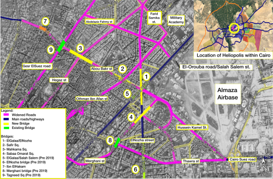
خريطة للشوارع الموسعة والكباري المنشأة حديثًا. تم تصميمها بواسطة المؤلف باستخدام خريطة أساس من خرائط Google Earth في 14 مايو 2020.
فبين ليلة وضحاها، فرضت محافظة القاهرة ووزارة النقل واقعًا جديدًا على سكان مصر الجديدة بدون أي استشارة أو حوار مجتمعي مع السكان. أثار إنشاء 5 كباري على أنقاض ميادين وشوارع خضراء موجة غضب مجتمعي من السكان، حيث أسفر هذا التغيير الجنوني عن إزالة حوالي 375,065 مترًا مربعًا من المساحات الخضراء والشجر، أي ما يعادل 95.3 فدانًا (375 دونمًا) طبقًا لبيانات من مبادرة تراث مصر الجديدة.
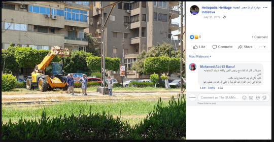
صور لعمال أثناء إزالة قضبان الترام تجهيزًا لزيادة عرض الشوارع وإنشاء الكباري. المصدر: مبادرة تراق مصر الجديدة.
يعد طريق القاهرة – السويس، الذي يبدأ من الحد الشرقي لمصر الجديدة وتحديدًا شارع الثورة، طريقا هامًا يربط القاهرة بمدينة السويس ومينائها الواقع على البحر الأحمر (وأيضًا المدخل الجنوبي لقناة السويس) ويمتد شرقًا لجنوب سيناء من خلال نفق الشهيد أحمد حمدي.
لكن منذ الثمانينيات بدأت التوسعات العمرانية والمدن الجديدة في الانتشار شرق القاهرة على جانبي طريق السويس، والذي منح هذه المدن الجديدة موقعًا استراتيجيًا بين العاصمة وميناء السويس، مما ترتب عليه جذبها للعديد من الصناعات التي انتقلت إلى بعض منها كمدينتي العاشر من رمضان وبدر. منحت هذه المدن أيضًا فرصة الوصول إلى الأراضي الرخيصة بهدف الاستثمار العقاري، والذي أدى بدوره إلى زيادة التدفق المروري على الطريق وخصوصًا قطاعه الغربي الذي يربط مصر الجديدة بهذه المدن في ضوء غياب مواصلات عامة جيدة في المنطقة.
بالتوازي مع زيادة التدفق المروري على طريق القاهرة – السويس، توالت عمليات توسعة الطريق والتي أدت في النهاية إلى تغيير مساره جزئيًا بهدف توسعته إلى 14 حارة مرورية مشيدة على أساس خرساني، ومع انتهاء الطريق عند المدخل الشرقي لمصر الجديدة، أصبحت المسافة بين طريق القاهرة – السويس وشارع الثورة بمثابة عنق زجاجة للتدفق المروري الداخل إلى الحي من خلال شارع الثورة.
في ظل وجود بدائل عديدة من شأنها الإسهام في تجنب جزء من التدفق المروري مثل رسوم الزحام والاستثمار في النقل العام، يبدو أن المخططين يصرون على ما يعتقدون انه الحل الأسهل: تحويل شارع الثورة إلى طريق سريع بسبعة حارات في اتجاه واحد إلى طريق السويس، بالإضافة إلى توسعة سلسلة من الطرق المحلية المتشعبة لتحويلها إلى طرق سريعة بسبعة حارات في اتجاه واحد بهدف تغيير مسار المرور العابر خلالها.
من جهة أخرى نجد مبادرة تراث مصر الجديدة، وهم أكبر مناهض للمشروع لم يضغطوا بشكل فعال - للأسف - للتأكيد على أهمية الحفاظ على قضبان الترام القائمة وتطويرها بغض النظر عن الجانب التراثي في الأمر،. فعلى سبيل المثال لم تعرض المبادرة إمكانية شراء قطارات جديدة للعمل على القضبان القائمة، الخيار الذي كان من شأنه تقديم حل للأزمة المرورية وخدمة مواصلات السريعة حتى وإن لم يحافظ على مظهر التراثي للقطارات، ففي منشور المبادرة ليوم 10 يناير المنقضي، تم عرض التحول للأوتوبيسات والسيارات الكهربائية (بالإضافة إلى مسارات الدراجات) ليس بهدف التحول للنقل المستدام، ولكن فقط لتقليل تلوث الهواء!
ويالرغم من أن تلوث الهواء يشكل بالفعل تحديًا واقعيًا، ولكن التحول للمركبات الخاصة الكهربائية وعمل بعض حارات الدراجات ليس من شأنه التعامل مع التحديات الأكثر شمولًا للنقل الحضري، كما أنه على الرغم من أن مسارات الدراجات تعتبر تغييرًا إيجابيًا، لكنها ستكتفي بخدمة نسبة قليلة جدًا من سكان القاهرة في ظل غياب المترو والترام وخطوط الأوتوبيسات المغذية لهم.
بالطبع تظل الحجج والآراء التي تهدف إلى الحد من تلوث الهواء مشروعة ومبررة في مواجهة مشروعات التوسع الجنوني في الطرق السريعة، ولكنها تظل عاجزة عن توضيح الفائدة العملية للحفاظ على البنية التحتية القائمة للترام وتطويرها أو حتى الفوائد العائدة على مدينة تشجع المشي (ومدينة تشجع المشي تعني مسارات مشاة وأرصفة أوسع وأأمن بالإضافة إلى نقاط لعبور الشارع بأمان وعدد أقل من كباري المشاة التي تشأ فوق طرق سريعة مزدحمة). هكذا كان الوضع حتى وسط مجتمع مصر الجديدة الغاضب ونقاشاته الصاخبة، حيث شكلت خسارة المناطق الخضراء والأشجار الناتجة عن إزالة الجزر الوسطى للطرق وتضييق الأرصفة حجة أخرى هامة في حد ذاتها في هذه النقاشات.
الحجج السالف ذكرها جميعها مشروعة، ولكنها لم تنجح في التعامل مع المشاكل الرئيسية -من وجهة نظري كباحث عمراني- حيث انها لم تتطرق إلى المشكلة الرئيسية التي أدت إلى هذه النتائج: كيف يرى معظم الناس المركبات الخاصة كجزء من المعادلة، ولا يفكرون في كونه اللاعب الرئيسي بيها وبالتالي أهمية وضع مخطط نقل حضري مستدام، يكفل الحركة للجميع بدون زحام مروري، وخسارة الفراغ العام لمساحات انتظار السيارات وبناء تقاطعات الطرق السريعة، وزيادة الانبعاثات، الجوانب التي تشكل جميعها آثارًا جانبية للمشكلة الرئيسية وهي آثار استخدام السيارة الخاصة على الفراغ العام المتمثل في الشوارع.
يجدر بي هنا بالطبع الإشارة إلى بعض الأصوات مثل الخبير العمراني أحمد الضرغامي، الذي نشر مؤخرًا فيديو عن تأثير زيادة عروض الطرق وكيف ينتج التوسع في إنشاء الكباري المزيد من المرور المُستحث، وفي السياق ذاته أوضح محمد حجازي، وهو زميل سابق وشريك مؤسس في مواصلة للقاهرة، عن محدودية المدى الزمني لتوسعة الطرق كحل للأزمة المرورية، حيث أنها ستنتج المزيد من المرور المُستحث في المستقبل القريب.
شرعت في يناير الماضي باستخدام حالة مصر الجديدة في صياغة وجهة نظر مختلفة، مشابهة لتلك التي قدمها زملائي، ولكن بمنظور متعدد الأوجه ومتقاطع التخصصات كالتالي:
علاقة ما يحدث بالتمدد العمراني المطرد لحدود إقليم القاهرة الكبرى
ما هو المحرك الرئيسي للتوجه نحو نظام نقل جماعي مستدام بشكل أساسي
تشجيع أشكال التنقل الغير آلي (مثل المشي وركوب الدراجات)
لوحة فنية توضح تخيل مستقبل "ديستوبي" لمصر الجديدة مع استمرار الكباري التي تقطعها.
لوحة: فريد فريد
فيما مضى، كان قلب المدينة كثيفًا بما فيه الكفاية ليكون المشي أكثر جاذبية في حركة الناس، وبشكل أساسي المشي إلى أقرب محطة مترو أو ميني باص، وكان ذلك خيارًا أكثر منطقية من قيادة السيارة الخاصة أو استخدام التاكسي. الكثافات العالية تساعد على جعل التوسع في مشروعات مترو الأنفاق أكثر كفاءة من حيث الجدوى الاقتصادية (بحيث أن التكلفة تُقسم على عدد الناس المخدومين من سكان ومترددين)، فيتضح دور هذه الكثافات في الإقبال الكبير على كل مقطع جديد يتم افتتاحه لمترو الأنفاق حتى قبل الانتهاء من الخط بأكمله (كما هي الحالة في الخط الثالث لمترو الأنفاق).
أوتوبيسي ترولي باص متصفان في شارع بوسط البلد في القاهرة، 1981
المصدر: صفحة Transportation Egypt على موقع فيسبوك
على الرغم من ذلك، ثمة بعض القلق بشأن تغير هذا الواقع، فالقاهرة تتحول إلى نموذج التمدد العمراني قليل الكثافة السكانية، وهو نموذج مبني بشكل أساسي على ملكية السيارة الخاصة بدلًا من استخدام النقل العام. ببساطة شديدة، لا يمكن إنشاء نظام نقل جماعي مجدٍ اقتصاديًا بدون توفر درجة معينة من الكثافة السكانية، وبذلك يعد مد شبكة النقل العام إلى المدن الجديدة أمرًا مرتفع التكلفة واستثمار من الصعب تبريره. ولذلك، فتراث مصر الجديدة كحي مبني على النقل العام هو ما خسرناه هنا، بالإضافة إلى المساحات الخضراء والجوانب الجمالية.
ما يجعل الأمر أكثر صعوبة بالنسبة لسكان القاهرة، ومنهم أنا، أن مصر الجديدة كانت لزمن طويل بمثابة خط الصمود أمام قاهرة ’جديدة’ يتم تشكيلها كمدينة ’للسيارات الخاصة فقط’.
إزالة خطوط الترام لصالح مشروعات توسعة الطرق ونقص الاستثمار في حافلات النقل العام ليس بالواقع الجديد على القاهرة. ففي بدايات ستينيات القرن الماضي، بدأت السلطات المحلية في التراجع عن نموذج التوسع في شبكة الترام والأوتوبيسات بإلغاء أجزاء صغيرة من شبكة الترام وإزالة الترولي باص الذي كان يمر في قلب القاهرة. في هذا الصدد أشارككم مقال كتبته ونُشر على موقع تضامن عن هذا الموضوع بالذات، ويتطرق إلى استراتيجية ترقيع الحلول التي لجأت إليها القاهرة منذ نهاية القرن التاسع عشر.
اشتركت غالبية مدن العالم، ومنها لندن، مع القاهرة في البدايات، حيث شركات عديدة قامت ببناء وإدارة وسائل المواصلات المختلفة. ففي لندن بالتحديد، تم بناء مترو الانفاق بواسطة Underground Electric Railways Company of London، بالإضافة إلى شركة Metropolitan Rail التي أنشأت بعض خطوطه، في حين أن الترام والأوتوبيسات كانت تتبع لشركات خاصة. على الرغم من ذلك، لاحظت سلطات لندن المختلفة الحاجة إلى تشكيل لجنة تخطيط مركزية مشتركة تشرف على عمليات التشغيل وخطط التوسع المستقبلية لشبكات النقل العام في لندن، وتمخض عن هذا الاهتمام تأسيس مجلس لندن لنقل الركاب في سنة 1933.
على الجهة الأخرى في القاهرة، وعلى الرغم من مشاركتها لندن في البدايات من حيث توزيع ملكية وإدارة النقل العام على عدة إدارات وشركات، إلا أنها افتقدت وجود لجنة أو مجلس متخصص غير بلدية القاهرة. وحتى ذلك تم تغييره فيما بعد كنتيجة لتأميم العديد من شركات النقل العام، حيث انتقلت تبعية ��يئة النقل العام بالقاهرة من بلدية القاهرة إلى القوات المسلحة ثم وزارة النقل قبل أن تعود مرة أخرى إلى بلدية القاهرة تحت مسماها الجديد ’محافظة القاهرة’ سنة 1971.
منذ ذلك الحين، استمرت شبكة ترام القاهرة في التقلص لتفسح المجال لمشروعات توسعة الطرق وإزالة قضبان الترام، ولم تتمكن شبكة الأوتوبيسات من التعامل مع حجم الركاب المنتقلين إليها. نتج عن هذا من جهة ظهور الميكروباص الغير رسمي، ولكنه أدى من جهة أخرى إلى استياء من النقل العام مما جعله خيارًا أسوأ وشجع القادرين على امتلاك سيارات خاصة واستخدامها في رحلاتهم اليومية، مما شكل عبئًا مروريًا إضافيًا على الطرق وبالتبعية أثر سلبًا على شبكات الأوتوبيسات المتداعية التي افتقدت تخصيص حارات خاصة لها (وحتى في حالة وجودها لم يتم تطبيقها كما هو الحال في التجربة قصيرة العمر لحارات الأوتوبيسات في صلاح سالم).
على الرغم من إشكالياته العديدة، شكل محور مصطفى النحاس للأوتوبيسات الاستثناء الوحيد الملحوظ، فعلى الرغم من قصر مسافته، شكل أحد التجارب المحدودة التي كُللت بالنجاح الجزئي في فصل حافلات النقل العام عن سائر المرور بواسطة حارات منفصلة. ولكن ذلك جاء على حساب إزالة المتبقي من قضبان الترام التي كانت تعمل على نفس الخط، وفي النهاية، بدلأ من أن يتم تطوير المشروع من حارة متوسطة للأوتوبيسات إلى نظام حافلات سريعة (BRT) كما اقترح فريق تضامن (أنظر الشكل التالي)، تم إزالة حارة الأوتوبيسات وتوسعة الطريق فيما بعد.

منشور بواسطة تضامن
و بذلك، كانت مصر الجديدة المثال الصامد للتنمية العمرانية المبنية على المواصلات العامة (Transit Oriented Development – TOD) في القاهرة، الذي بُني قبل أن تتم صياغة المصطلح بواسطة الأكاديميين وقبل عصر المؤسسات الدولية المانحة. صمد ترام مصر الجديدة إلى الألفينات، ففي عام 2012/2013 كنت أستخدم دوريًا خط الترام المحاذي للمطرية، من ميدان سفير إلى محطة مترو حلمية الزيتون في طريقي إلى وسط البلد، متخذًا رحلة تبادلية بين الترام والمترو، وعلى الرغم من كون الترام قديمًا وبطيئًا آن ذاك، كان يوفر لي رحلة أفضل حيث الزمن ويعمل بشكل جيد.

ميدان سفير (قبل إنشاء الكباري) المصدر: صفحة ’أنا من مصر الجديدة’ على فيسبوك
ميدان سفير في أغسطس 2019 (في بداية إنشاء الكباري) المصدر: مايكل حنا
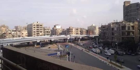
ميدان سفير في يناير 2020 (بعد إنشاء الكباري وإزالة قضبان الترام) المصدر
لذلك، من المحبط رؤية إهدار قيمة التصميم العمراني وإرث المواصلات العامة الذان اتسمت بهما مصر الجديدة، ومن المحزن إزالة بنية تحتية للسكك الحديدية بقيمة تعادل مليارات الجنيهات، لاسبتدالها فقط بكوبري علوي.
ما يزيد من الألم هو إقدام الإعلام وفي مقدمته ذلك المملوك للدولة على الاحتفاء ببداية العمل في كباري مصر الجديدة ’الجديدة’، زاعمين بأنها "عودة لجمال مصر الجديدة التي شيدها البارون امبان". ولا إدري لو كان البارون امبان حيًا ليرى ما يحدث لشبكة ترامه المتشعبة ومشروع حياته، ما إذا كان ليتفق مع هذا التصريح بالنيابة عنه.
الأخبار اليوم "مصر الجديدة تستعيد جمال البارون امبان" 12 يناير 2020 المصدر
الهدف من كل هذه المحاور والكباري واضح: مع تحول طريق السويس من كونه طريق يربط بين محافظتي القاهرة والسويس ��لى كونه المغذي الرئيسي للمدن الجديدة شرق القاهرة، كان لا بد من فعل شيء لاستيعاب هذا الكم من المروري الإضافي
زيادة عرض الطرق بهذا الشكل بدون أية اعتبارات لعبور المشاة بأمان سيغلب على أي فائدة من التوسع في شبكة الطرق، بالإضافة إلى العدد الإضافي من الرحلات بالسيارات الخاصة، والناتج عن اضطرار السكان لاستخدامها في رحلاتهم داخل الحي وليس فقط في رحلاتهم اليومية إلى خارجه، حيث سيستخدمون سياراتهم لأغراض لم تكن تحتاج إلى تنقل آلي فيما سبق مثل إيصال الأطفال إلى مدارسهم وشراء الاحتياجات المنزلية الأساسية.
الترام يخترق شارعًا رئيسيًا بمصر الجديدة فيما مضى، القاهرة 2004 المصدر: كريستوف جرونيك
قمت بالتحدث مع خالد مصطفى، وهو مهندس نقل ومرور، واتفق معي على أن هذه الخطط عبثية تمامًا، حيث قال "لا تستطيع إنشاء طريق حر في المناطق التي تتوقع فيها مرور المشاة". بالنسبة لخالد مصطفى، أي حل لهذه المعضلة سيكون معقدًا وسيزيد من تعقيده مواءمة الأهداف المرجوة للوصول إلى تدفق مروري حر وفي نفس الوقت الحفاظ على الطرق آمنة للمشاة. أضاف مصطفى بحزن "للأسف ولأول مرة لا أستطيع الموصول لحل لهذه المشكلة المعقدة"، وأضاف أن هذه الطرق الحرة الجديدة ستخلق تدهورًا عمرانيًا حولها: "ما فعله الناس حول الطريق الدائري، سيحصل الآن في مصر الجديدة".

عربة إسعاف تصل إلى مكان حادث صدم سيارة لأحد المشاة تحت أحد الكباري المنشأة حديثًا في مصر الجديدة.
المصدر: صفحة "Heliopolis 1905 على فيسبوك"
منذ بداية أعمال إنشاء الكباري وتوسعة الطرق منذ ستة أشهر، وقع ما لا يقل عن أربعين حادثة تصادم بين المركبات والمشاة على الطرق الموسعَة حديثًا بسبب نقص وانعدام كفاءة البنية التحتية المخصصة للمشاة. استجابة مرور القاهرة اقتصرت على مراقبة سرعات المركبات بالرادار عند نقاط معينة على المحاور بالإضافة إلى مسارين لعبور المشاة وبعض اللوحات الإرشادية.
عندما سألت خالد مصطفى عن حدود السرعات الجديدة التي وضعت لهذه المحاور ومحاولة إدارتها من قبل مرور القاهرة، ألمح إلى أن هذه الحلول تم تطبيقها فقط بعد المطالب المجتمعية والتي كان منها تلك المطالب التي رفعتها مبادرة تراث مصر الجديدة، والتي طالبت بالتحرك وفعل شيء تجاه حوادث الوفاة والإصابات الناتجة عن غياب ممرات آمنة للمشاة. وأضاف أيضًا أن حد السرعة عند 60 كم/ساعة هو قليل بالنسبة للطرق الحرة، وتساءل "إذا كانت الخطة تتضمن التحكم والحد من سرعات المركبات، لماذا تم بناء طريق حر منذ البداية؟".
طبقًا لمعهد الموارد العالمي (WRI) ، أحد الطرق لجعل المدن أكثر أمانًا وصحية هو تغيير تصميم طرقها وأحيائها. حيث يشير التقرير الصادر عن المعهد لمدن أكثر أمانًا من خلال التصميم، يشير إلى العوامل الرئيسية التي تجعل الشارع آمنًا للمشاة وكذلك المجتمع ككل:
تصميم المدينة بناءً على نموذج متصل وكثيف، مما يقلل الحاجة إلى قيادة السيارة ويقصِر أطوال الرحلات
تقليل سرعة المركبات بشكل جذري إلى السرعات الدنيا، أي ما يقل عن 30 كم/ساعة. يذكر التقرير أن "الخطر على حياة المشاة في حالة سرعة 50 كم/ساعة للمركبات هو أكثر من ضعف الخطر في حالة سرعة 40 كم/ساعة وأكثر من 5 أضعاف الخطر في حالة 30 كم/ساعة" كما هو موضح في الشكل أدناه
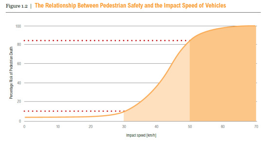
المصدر: تقرير معهد الموارد العالمي بعنوان "مدن أأمن من حيث التصميم"، رابط
إدارة الطرق الشريانية للتأكد من إتاحتها للعديد من وسائل المواصلات والحفاظ على سرعة المركبات تحت 40 كم/ساعة، خاص في المناطق ذات الاستعمالات المتنوعة للأراضي. "ينبغي على الطرق السريعة أن تكون مفصولة تمامًا عن حركة المشاة وركاب الدراجات والمناطق ذات الاستعمالات المتنوعة للأراضي"
دعم وسائل النقل غير الآلية كالمشي وركوب الدراجات وكذلك وسائل النقل الجماعي
رسمة كاريكاتير هولندية من عام 1965 مع وصف يقول: "1975 السائر الأخير" المصدر: Fritz Behrendt, "De Laatste Voetganger," De Telegraaf, ca. 1965

صورة مستخرجة من فيديو لمرور القاهرة توضح فردين من شرطة المرور يساعدان إحدى المارة في عبور الشارع الموسع حديثًا في مصر الجديدة. المصدر: فيديو على يوتيوب
إذا قارننا هذه الشروط مع ما حدث بالفعل في مصر الجديدة والقاهرة الجديدة وسائر المدن الجديدة (الضواحي)، سنجد أن التطورات التي تمت في مصر الجديدة وتوسعة طريق السويس وكل الطرق السريعة الجديدة تعارض كافة الاشتراطات المذكورة في تقرير WRI.
تقضي السياسات العامة التي تتبعها محافظة القاهرة ومحافظة الإسكان وهيئة المجتمعات العمرانية الجديدة بخلخلة الكثافة السكانية للقاهرة بدلًا من استغلال هذه الكثافة لدعم المشي والنقب الجماعي وتطوير مسارات محمية للدراجات على سبيل المثال.
خريطة تم تطويرها بواسطة المؤلف باستخدام جوجل إيرث برو. توضح الخريطة مشروعات التطوير العقاري المتعددة بين المدن الجديدة والتي ستملأ المساحة بين العاصمة الإدارية الجديدة والقاهرة الجديدة ومدينتي الشروق وبدر في النهاية.
خريطة تم تطويرها بواسطة مكتب استشاري لموقع العاصمة الإدارية الجديدة. توضح الخريطة أن العاصمة الإدارية الجديدة منفصلة عن القاهرة الجديدة والقاهرة. رابط
وعلى الرغم من أن العديد من الخرائط تصور المدن الجديدة منخفضة الكثافة مثل العاصمة الإدارية الجديدة ككيانات منفصلة ويتوسط المسافة بينها وبين القاهرة ارض صحراوية أو ريفية، إلا أن كافة الشواهد على أرض الواقع لا تشير إلى استقلالية أي من هذه المدن عن القاهرة كمركز عمراني للخدمات الأساسية والغير أساسية. امتلأت المساحات الفاصلة بين القاهرة الجديدة والعاصمة الإدارية بكافة أنواع التنمية العقارية ومنها المجتمعات المسورة التي توفر مناطق سكنية للعائلة الواحدة (فيلات وتاون هاوس) وعمارات من 4 أو 5 أدوار بالإضافة إلى مباني مكتبية. المثل يسري على المساحة الفاصلة بين مدينة نصر والقاهرة الجديدة حيث تم بناء العديد من المجتمعات السكنية، وبعضها مازال قيد الإنشاء خاصة على طريق السويس.
نستنتج من ذلك أن هذه المدن ستظل تستنزف موارد القاهرة وقدراتها الاستيعابية بدلًا من أنت كون مدنًا مستقلة ومكتفية بذاتها. في معظم الأحيان لا تقف الآثار السلبية لهذا عند زيادة الضغط المروري على القاهرة فحسب، بل يمتد هذا الأثر إلى إرهاق الموازنات المالية الخاصة بالأحياء القديمة والمسكونة بالفعل في قلب القاهرة.
على الرغم من كون القاهرة بهذه الأهمية بالنسبة للمدن الجديدة، يتعرض احتياجها للاستثمارات في بنيتها التحتية ووسائل النقل الجماعي للتجاهل أو التباطؤ في أفضل الأحوال (كام هو الحال في مشروعات مترو الأنفاق) أو توجيه الاستثمارات بشكل حصري لخدمة المدن الجديدة وسكانها، فعلى سبيل المثال: بالرغم من الخطة القائمة لبناء 6 خطوط مترو أنفاق في القاهرة منذ نهاية التسعينيات، يظل التقدم بطيئًا بشدة بسبب توجيه معظم المال العام المتاح إلى بناء طرق سريعة جديدة وتوسعة الطرق القائمة.
المخطط العام لشبكة مترو أنفاق القاهرة الكبرى كما هي من الهيئة القومية للأنفاق. رابط
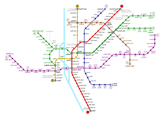
رسم يظهر بشكل اكثر وضوحًا المخطط العام للمترو بناءً على بيانات الهيئة القومية للأنفاق. الرسم: عبد المؤمن. المصدر
تكمن الأسباب الرئيسية وراء التأخير في بداية مشروعات المترو الجديدة في مسائل تتعلق بالتمويل أو بسبب التعقيد البيروقراطي، فعلى سبيل المثال أُجلت البداية في إنشاء الخط الرابع للمترو (والمخطط خدمته لمناطق حيوية عديدة مثل المتحف المصري الكبير وهضبة الهرم) مرات عديدة بسبب نقص العروض المناسبة المقدمة إلى وزارة النقل المصرية كجزء من الطلب المفتوح للعروض.
في نهاية المطاف، تم إسناد العمل لتحالف من الشركات المحلية والعالمية لبدء الأعمال في الخط الرابع بعد ثلاثة سنوات من نشر الطلب الأول للعروض. يعد هذا إهدارًا هائلًا للوقت الذي كان من الممكن استغلاله للإنشاءات في ضوء افتتاح المتحف المصري الكبير هذا العام، وحيث أن كافة الخطط والدراسات التقنية تم انجزاها بالفعل منذ زمن طويل (ملحوظة: تم تأجيل افتتاح المتحف المصري الكبير نظرًا لأزمة فيروس كورونا المستجد)
تحديثات واستنتاجات مفتوحة
تزامنًا مع كتابة هذا المقال، نشر سكان شارع ترعة الزمر (والذي يعد جزءًا من إقليم القاهرة الكبرى) عدة صور للجزء المنشأ حديثًا من الكوبري والطريق السريع الذي غطى عرض الطريق بأكمله وكادت حوافه تلامس المباني المجاورة!
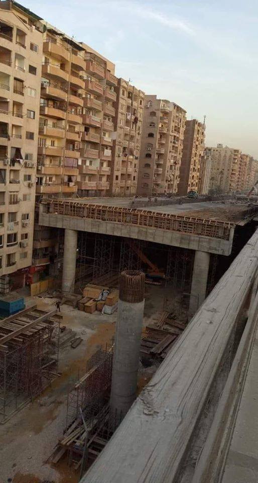
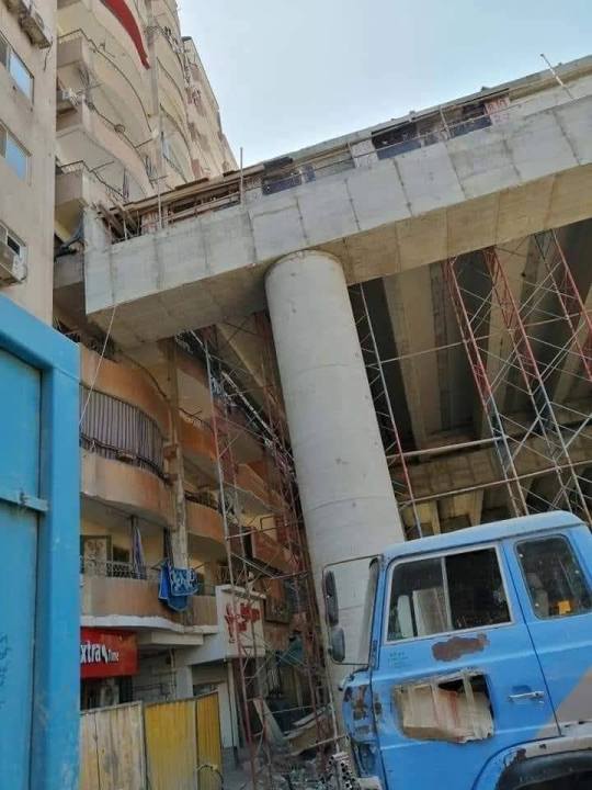
صور تم التقاطها بواسطة سكان شارع ترعة الزمر للإنشاءات التي تتم بالمنطق. رابط: مستنير شادي أحمد
يفترض للمحور المدعو "بمحور الملك سلمان" أن يربط القوسين الشرقي والغربي من الطريق الدائري. كان هذا القرار ليبدو منطقيًا لولا تواجد رابط بالفعل على بعد عدة كيلومترات غربًا. هذا الطريق السريع الإضافي دون مبرر هو مثال لكيفية إهدار المال العام في إنشاء الطرق في حين تعاني أجهزة وسلطات النقل الجماعي في تحسين مواردها المالية اللازمة لتوسعة شبكة المواصلات.
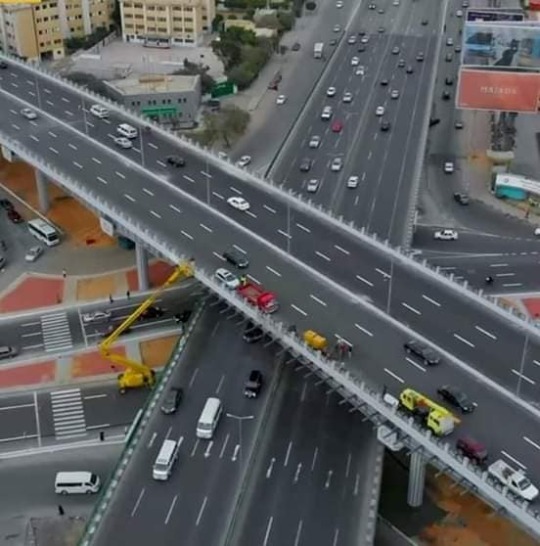
صورة جوية لتقاطع شوارع صلاح سالم والنزهة وأبو بكر الصديق والجلاء، ويوضح الكباري المنشأة حديثًا.
المصدر: محافظة القاهرة
من الواضح أننا في مواجهة موقف متناقض تمامًا، حيث تعاني خدمات النقل الجماعي من ضعف الاستثمارات، ويتم إجبار عدد أكبر من الناس على اختيار قيادة السيارات الخاصة واستخدام وسائل النقل الخاصة الأخرى والتي تؤدي بدورها إلى تفاقم مشكلة الزحام المروري. تجاهل الجذور التي أدت إلى هذه الكارثة في المقام الأول مصحوبة بالحلول المؤقتة كتوسعة الطرق القائمة وإنشاء الطرق السريعة والكباري، التي ستوفر حل لمدة قصيرة من الزمن قبل أن يفاقم المرور المستحث من مشكلة الزحام المروري، والذي بدوره سيؤثر سلبًا على وسائل النقل الجماعي ويقلل من كفاءتها بسبب زيادة زمن الرحلات، ويضع ضغطًا إضافيًا على مترو الأنفاق المضغوط بالفعل. المزيد من الناس سيستخدمون وسائل النقل الخاص بسبب تدهور جودة النقل الجماعي، وتستمر الدائرة.
youtube
عن تدمير الطرق السريعة للمدن الأمريكية
#urban#public transit#bridges#highways#cairo#heliopolis#metro#القاهرة#مترو الأنفاق#كباري#العاصمة#المدن الجديدة#توسيع شوارع
1 note
·
View note
Text

It’s amazing how most debates around public transport and cycling infrastructure still stir up arguments about the amount of space they occupy from the surface roads and paths of our cities. It’s even more dazzling to hear arguments about how cars might be a safe mode of transit in the times of #COVID19 and a #Coronavirus pandemic, citing photos of crammed public transport vehicles and facilities, and the potential of such crowdedness in spreading the virus.
The public imagination of what public transport and mass transit facilities should look and feel like hasn’t, understandably, gone beyond the current situation and typical seating designs that maximizes capacity over comfort and hygiene.
Why is it that cars don’t have to go through a similar design process? Why is it that cars despite increasing in size, especially SUVs) actually end up having less capacity; and in most cities it’s occupancy rate never goes beyond the typical 1 or 2 commuters per car average?
Why is it that cars, with such higher footprint and lower capacity gets that much space off our streets, while buses and cyclists are relegated to short strips of narrow colored lanes, or pushed altogether into crammed underground/overground trains maximized to have maximum capacity on the expense of safety and hygiene? Why is it that we have to compromise comfort and commuter experience when we design trains and buses, but don’t do that for private vehicles?
Illustration by Fabian Todorovic
2 notes
·
View notes