
bsawinart
BSSart.com
Artwork of Benjamin Sawin
Various forms of creativity expressed in whatever medium made accessible.
456 posts
Don't wanna be here? Send us removal request.
Last Seen Blogs

christreginlave
✧➹♡✚☆✦☽.

lilly-french
French Kiss

no-hugs-peach
Dancing Through Life

gunnell-blog1
Moments
pktourplanner
Pakistan Travel Guide Trip Vacation Packages
Photo
Lavonia Park, on Lavon Lake, outside of Dallas.
Funny story, This location was only photographed because previous plans fell through due to a catfishing scheme, via tinder, that almost lead to a robbery.
Be wary when asked to meet someone at a cul du sac in a trailer park that looks half abandoned.
Started in 1948 and completed in 1953, the Lavon Dam was created to impound the upstream East Fork of the Trinity River, some of its tributaries, and the areas immediately surrounding them. The reservoir was primarily designed for preventing seasonal flooding of rich bottomland in northeastern Collin County, and water storage. Its construction also stimulated land development along the shores of the lake and recreational use of the water and adjacent land areas. In 1962, Congressional approval was given to modify the project to increase storage for water supply because of the growing water supply need of the area.[ Also part of the modification was to add recreation as a purpose for the lake. This focused management and development for public use, recreational activities, and stewardship of the water and land areas.
#sunset#art#wine#drink#texas#sun#dusk#sunset over water#lake lavon#lavon#lavonia#lavonia park#hicksville#bumfuk#bumfuck#cowboy#cowboys#rocky coas#rocky coastline
0 notes
Photo
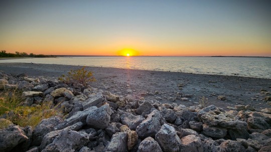
Balmorhea Lake, a setting sun over the mountains, while a dust storm rolls in.
The winds and dust battered the van all night, just howling over the water.
At some point, some animals took cover under the van, I caught the movement on my cameras, but due to the dust I couldnt make out what it was. Sure did get the neck hairs standing on my pups in the morning. Very interested in the smells.
This was a night on my way through Texas on my way to Az.
You have to roll through this run down town, it looks like every cliche group of shacks in every movie about meth.
The entire experience was totally worth it though, and I appreciate having done it.
Historians believe that this area of lake has been around for more than 11,000 years. This means that this lake has provided resources for Native tribes and animals that may be extinct today. The reservoir was built in 1917 by the construction of a dam by the Reeves County Water Improvement District. The reservoir provides water for irrigation, and is a popular recreational spot for locals. Balmorhea Lake is also known as Lower Parks Reservoir.
Now, to clarify, this was at Balmorhea Lake, and not the state park. So I cant attest to the park itself.
Balmorhea State Park is a 46-acre (19 ha) state park located on the San Solomon Springs in Reeves County, Texas, opened in 1968. The closest city is Balmorhea, Texas. Texas Parks and Wildlife Department manages the park. The park is open year-round, and visitation is capped at 900 people per day.
#texas#camping#opverland#balmorhea#state park#overland#vanning#vanner#vanlife#sunset#dust storm#dustbowl#photography#nature#nature photography#texas landscape
3 notes
·
View notes
Photo

River Trails in Big Basin Redwoods State Park
There are worse places to walk your dog. But heres the thing, Dogs arent allowed in state or county parks in California. I mean, as if you needed another reason to justify why this is one of the most hated states in the country. But seeing as how I have zero respect for the state or its idiotic laws, we hiked away into the wilderness.
The state has an amazing beauty to it, its a shame that its residents ruin it.
0 notes
Photo

Spent the day out in Santa Cruzs Redwood Forest.
Came across so many of these trees growing in a perfect circle. When I got home I had to search and find out more about why this happens and what it is.
Apparently they are called fairy rings. Ive only heard this applied dto mushrooms. A fairy ring is a common name for a group of redwood trees growing in a circle, usually around the stump of a logged old-growth tree. After being cut down, a new generation of trees sprout from the roots of the fallen redwood, often creating a near-perfect circle or ring. This is one of the ways redwoods regenerate, giving them the tremendous advantage of already having a full root system compared to species that reproduce through seed.
Established in 1902, Big Basin Redwoods is California’s oldest state park. In the heart of the Santa Cruz Mountains, its biggest attractions—literally—are its ancient coast redwoods. Some of these giants are more than 50 feet around and as tall as the Statue of Liberty. At 1,000 to 1,800 years old, some may predate the Roman Empire. The park also offers spectacular views of the Pacific Ocean, lush waterfalls, and a fascinating natural and cultural history.
Its been a bucket list item of mine for a long time. Since I have the time, I think me and my dog will be back to take it all in again this week.
#redwood#tree#nature#national park#california#redwood forest#redwoodforest#sequoia#naturephotography#photography#art#artwork#long walks#nature walks#fairy ring#Fairie ring#circle#aperfect circle#a perfect circle#apc#santa cruz
0 notes
Photo
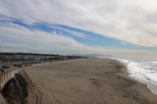
Point Lobos Ave
overlooking Ocean beach, San Francisco
from the parking lot of Camera Obscura, a leftover remnant of the SF playland.
I love old roadside attractions.
a steam railroad was in place by 1884 to bring people to the first amusement ride at the city's oceanside, a "Gravity Railroad" roller coaster, and to the Ocean Beach Pavilion for concerts and dancing. By 1890, trolley lines reached Ocean Beach: the Ferries and Cliff House Railroad, Park & Ocean Railroad, and Sutro Railroad that encouraged commercial amusement development as a trolley park. The Cliff House, which opened in 1863, and Sutro Baths, which opened in 1896, drew thousands of visitors.
0 notes
Photo
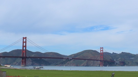
Spending a month in the bay area of California.
Obviously one of my first stops was the golden gate bridge.
The Frommer's travel guide describes the Golden Gate Bridge as "possibly the most beautiful, certainly the most photographed, bridge in the world." At the time of its opening in 1937, it was both the longest and the tallest suspension bridge in the world, with a main span of 4,200 feet
Before being built, the bridge faced opposition, including litigation, from many sources. The Department of War was concerned that the bridge would interfere with ship traffic. The US Navy feared that a ship collision or sabotage to the bridge could block the entrance to one of its main harbors. Unions demanded guarantees that local workers would be favored for construction jobs. Southern Pacific Railroad, one of the most powerful business interests in California, opposed the bridge as competition to its ferry fleet and filed a lawsuit against the project, leading to a mass boycott of the ferry service.
I never knew that. Learn something new every day I guess.
#golden gate park#golden gate bridge#san francisco#cali#california#another bridge picture#golden#gate#shower#bay area#danny tanner#traveler#traveling contractor#see the world#vanlife#wanderlust#meander
1 note
·
View note
Photo
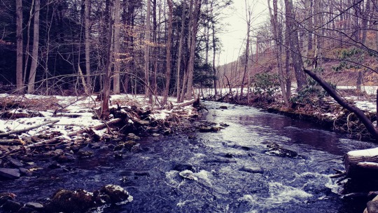
I left State College in July, not wanting to come back.
Well, here it is December, and Im back again.
Working on a project within the city limits, and spending off hours outside of them.
State College evolved from a village to a town to serve the needs of the Pennsylvania State College, founded as the Farmers' High School of Pennsylvania in 1855. State College was incorporated as a borough on August 29, 1896, and has grown with the college, which was renamed The Pennsylvania State University in 1953.
In 1973 State College adopted a home rule charter which took effect in 1976; since then, it has not been governed by the state's Borough Code, although it retains "Borough of State College" as its official name.
#pennstate#penn state#state college#statecollege#pennsylvania#mountains#river#stream#winter#cold#viewsfordays#teecking#trecking#exploring#explorer#heated jacket#too cold#dont want it#treesofinstagram#nature#photography#nature pgotography
0 notes
Photo

Toms River, New Jersey
Toms River can be seen in various TV and news media including MTV's Made and Jersey Shore (seasons 1, 3, and 5), HBO's Boardwalk Empire and the original The Amityville Horror movie. In 1998, Toms River East Little League won the Little League World Series. The township has what is said to be the second-largest Halloween parade in the world.
Much of the early history of the settlement of Toms River is obscured by conflicting stories. Various sources list the eponym of the township as either English captain William Tom,[26][27] or farmer and ferryman Thomas Luker. In 1992, as part of celebrations commemorating the township's 225th anniversary, official recognition was granted to the tradition that the "Tom" in "Toms River" was for Thomas Luker, who ran a ferry across Goose Creek (now the Toms River).[28] During the 19th century, Toms River became a center for shipbuilding, whaling, fishing, and iron and lumber production. The settlement and the river were usually spelled "Tom's River" in its early days, though its current spelling has been standard since the middle of the 19th century.
You can order this print for as low as 14 dollars
#jersey shore#beach#sand#photography#travel photography#pictures#art#artwork#new jersey#new jersey photography#pics#nature pics#beach pics#sandy bottom#waves#water#ocean#oceanic#pirates l;ife for me
0 notes
Photo

A vintage styled line art piece featuring a black bird sitting on the rum on a glass of scotch. Also on the table is a revolver and bullets. Print comes digitally signed.
This is an older piece, but I just noticed I hadnt made prints available.
So heres a link, and prints are starting off at just 17.00.
Check it out!

#raven crow whiskey booze cocktail bullet pistol revolver handgun black bird alcohol rounds scotch gun noir retro vintage nostalgia classic t#raven#crow#bullet#9mm#revolver#line art#sketch#drawing#picture#art#artwork#38 special#bird#flying#animal#animal art#vintage#retro#classic#print#fine art print#poster#posters#lineart#alcohol#scotch#drink#drank#drunk
0 notes
Photo
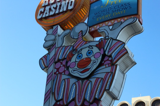
Recent trip to Reno, had as problem where pictures from certain city blocks wouldnt save. took multiple trips, with different SD cards, same issue. Odd coincidence.
Anyways, here is Topsy.
The Circus Circus Hotel & Casino opened in 1978 and this huge sign depicting Topsy the Clown appears to be from then. The sign was designed by Gordon Tietjen and produced by YESCO. I believe the panels were replaced sometime after 2003. The clown has different eyes and nose now. The photo above is from 2014. A taller Circus Circus sign with a different design was installed in Las Vegas two years earlier.
TOPSY THE CLOWN HAS BEEN in Reno since Circus Circus opened on July 1, 1978. He’s hard to miss, as he’s no small clown—he stands 127 feet tall and weighs 44.8 tons.
Topsy was designed by Gordon Tietjen and manufactured by Young Electric Sign Company, YesCo. YesCo is known for their neon in the casino industry. YesCo’s art can be seen across Nevada.
Time hasn’t always been kind to Topsy, and he once took quite a beating. On January 15, 1988, Reno was hit with a storm with wind gusts up to 94 miles per hour. These winds caused the Virginia Street area to be closed, as windows were being blown out and Topsy was losing parts of himself. The city grew concerned that Topsy was going to be blown over. But fortunately, he stayed up during the storm.
#signage#reno#travel#traveler#atlas obscura#wanderlust#neon#casino#topsy the clown#clown#circus circus#advertising#vintage#nevada#old timey#retro#light#lights#lighting
0 notes
Photo
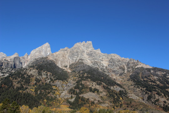
Teton National Forest was first established by the General Land Office on February 22, 1897 as the Teton Forest Reserve with 892,440 acres (3,611.6 km2). A commission was established in 1896 to plan for a system of national forest reserves, recommending an expansion of the territory protected by the Yellowstone Timberland Reserve. President Grover Cleveland's 1897 proclamation established a protected area encompassing the northern end of Jackson Hole, extending from the south boundary of the Yellowstone Forest Reserve south to the area of the Gros Ventre River, and from the Idaho border in the west to the area of the Continental Divide in the east. Much of this area would eventually be incorporated into Grand Teton National Park. In 1902 the southern porion of the Yellowstone reserve was added, while the Teton Reserve was greatly expanded to the south and east while excluding the southern portion of Jackson Hole around the town of Jackson.
On January 29, 1903 it was combined with the Yellowstone Forest Reserve, but it was reinstated as a separate unit on July 1, 1908 with 19,911,200 acres (80,578 km2). In 1973 Teton National Forest was administratively combined with Bridger National Forest, creating Bridger-Teton National Forest. In descending order of land area, Teton National Forest is located in parts of Teton, Sublette, Park, Fremont, and Lincoln counties. It is now administrated as part of the Bridger-Teton National Forest from its headquarters in Jackson, but there are local ranger district offices in Jackson and Moran. The forest contains both the Gros Ventre Wilderness and the Teton Wilderness, both officially designated by the National Wilderness Preservation System.
#grand teton#tetons#photography#pics#picture#pictures#nature pics#nature photography#nature photo art#nature#mountain view#mountains#painted mountains#famous#tree#traveler#travelblog#travel#overland#overlanding#park#national parks#national park#National#america
0 notes
Photo

Gibbon Falls drops 84 feet (0.3 m) over a remnant of the Yellowstone caldera rim. The caldera was created by a massive volcanic eruption approximately 640,000 years ago.
Gibbon Falls is located on the Gibbon River about midway between Norris Geyser Basin and Madison Junction. The falls are situated where the Gibbon River falls off the Northern escarpment into the Yellowstone Caldera.
The falls were first described by William Henry Jackson during the second Hayden geological survey of 1872. There is no historical record as to how they got their name, but by the mid-1880s, they were routinely referred to as Gibbon Falls in both government and commercial accounts of the park.
In 1883, in his The Yellowstone National Park-A Manual for Tourists, Henry J. Winser described the falls:
Falls of the Gibbon-These are situated four miles from the entrance to the canón, and are reached by a trail on the right of the road. The descent is quite steep, but the stalwart tourist wlll not regret the strain upon his muscles after a sight of the magnificent falls. The water tumbles over them in a foamy sheet, full eighty feet in depth, making a charming picture, full of life and vigor, which is in striking contrast to its setting or grim rocks and dusky pines. After leaving the falls and the foaming river, the road soon crosses Canón Creek, passing for the next eight miles over a succession of pine and fir clad terraces, the charms of which are apt to cloy, before the next attractive point is reached.
#gibbon falls#wyoming#nationl park#national parks#yellowstone#photography#backroads#wanderlust#trees#ecology#nature photography#waterfalls#waterfall photography
0 notes
Photo
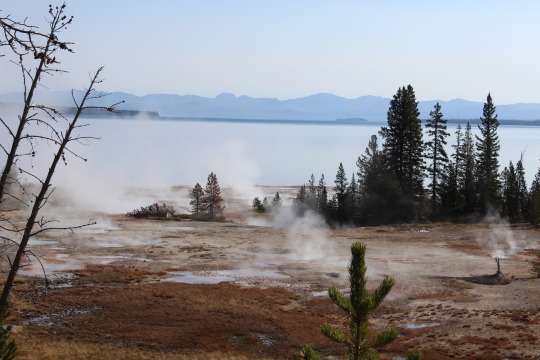
I learned so much from this trip to Yellowstone. Saw so many beautiful sights that I just didnt believe were real in nature.
This area was blocked off to prevent people from injuring themselves, as the liquids were listed as more corrosive than battery acid.
I was calling this area geysers, but in reality they are Fumaroles
The hottest hydrothermal features in the park. Limited amount of water in these features causes water to flash into steam before reaching the surface. Also known as steam vents.
Did you know Old faithfuls intervals are getting longer between events? Also it isnt even the biggest at yellowstone.
Tucked away in the Norris Geyser Basin is Steamboat Geyser, the world’s tallest active geyser. Its major eruptions shoot water more than 300 feet (91 m). Only Waimangu Geyser in New Zealand has rocketed to greater heights—but not in more than one hundred years. In Yellowstone National Park’s recorded history, only two other geysers have exceeded Steamboat in size: Excelsior Geyser in Midway Geyser Basin and Sapphire Pool in Biscuit Basin. Steamboat’s minor and major eruptions used to average a year between events, but now it has shortened to an average of 5 days.
#yellowstone#geyser#old faithful#national park#national park service#park#nature#photography#super volcano#nature photography#photos#pics#trees#autumn
4 notes
·
View notes
Photo

Another great shot on Hwy 26 in Wyoming.
From Alpine, US 26 is co-signed with U.S. Route 89 east and north to Hoback Junction, then co-signed with US 89, U.S. Route 189, and U.S. Route 191 to Jackson. US 189 ends in Jackson, and the other three highways continue their concurrency through Grand Teton National Park up to Moran. At "Glacier View Turnout," a view of Teton Glacier, on the north of Grand Teton, can be seen. At Moran, US 26 turns east, concurrent with U.S. Route 287. Crossing the Continental Divide at Togwotee Pass, US 26 passes through Dubois, Wyoming, the end of the Wyoming Centennial Scenic Byway, and at Diversion Dam Junction, US 26 and US 287 separate; US 26 continues southeast to Riverton, then northeast to Shoshoni. From Shoshoni to Casper, US 26 is co-signed with U.S. Highway 20. US 20-26 has a bypass north of Casper, the eastern half of which is concurrent with Interstate 25 and U.S. Route 87. US 20-26-87 parallels I-25 from Casper to Glenrock; east of Glenrock, US 26 (along with US 20 and US 87) is co-signed on I-25. US 26 follows I-25 to Dwyer Junction, where it turns east to continue along the Old Oregon Trail. US 26 passes through Guernsey, Fort Laramie, Lingle, and Torrington before entering Nebraska. U.S. Route 85 is concurrent with US 26 between Lingle and Torrington.

Order this print
#hwy26#oregon trail#american history#americana#photography#photos#new stuff#new art#new pictures#pic of the day#nature#trees#fall colors#morning haze#road trip#roadtrip#backroads#see ameri
0 notes
Photo

Just Outside of Boise Idaho
Im still upset Idaho has kept its amazing awesomeness hidden from the rest of America for so long.
You can order this print here,
https://fineartamerica.com/featured/idaho-bridge-ben-sawin.html?product=poster
#idaho#who knew#back roads#photography#america the beautiful#traveler#these are the pictures i take#these are the things i see#Boise#trains#bridges#nature#beautiful beautiful#beauty#Love#sceniccaf#scenery#scary#beautiful scenery
0 notes
Photo

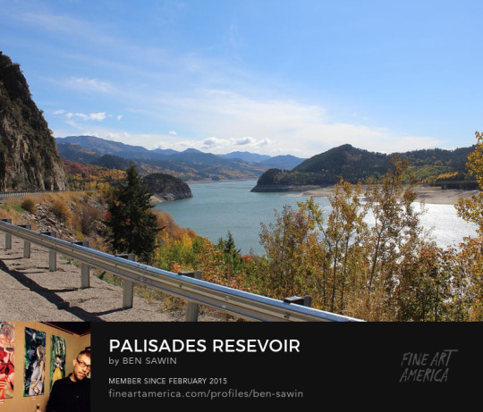
Palisades Reservoir is formed by Palisades Dam, which is a major feature on the Palisades Project. Recreation on this 25 square mile (16,100-acre) reservoir with 70 miles of limited access shoreline is administered by the Caribou-Targhee National Forest. Located in scenic southeast Idaho and west-central Wyoming, east of Idaho Falls. Palisades' fish species include cutthroat and brown trout, kokanee and mackinaw. The fishing season is year-round, but fluctuations in the reservoir level during the summer months result in inconsistent fishing. Spring, fall and winter ice fishing are most productive.
Palisades Reservoir is in a scenic valley with forested hillsides rising from the water to the towering snowcapped mountains which form the background. The reservoir has six access roads that have been built. Public use facilities include five campgrounds, five picnic areas, and six boat ramps.
This image is from the backside of Tetons national park, on hwy 26, part of the original Oregon Trail.
You can order a print or sticker of this image here...
#palisades#wyoming#back roads#photography#damn#dam#pictures#art#nature#nature photography#overlanding#camping#glamping#seeing america#america the beautiful#oh#nature photo art#backgrounds#backroads#national park#personal#camp#pics#trees#beautiful beautiful#beautiful scenery#scenery#scenis#gorgeous gorgeous
1 note
·
View note
Photo
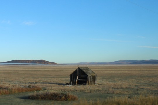
Another photo from the Pioneer Historic Byway
Pioneer Historic Byway retraces some of the steps taken by Idaho’s early pioneers and early-day Yellowstone Park visitors. Along the way you can see the remnants of the first grist mill in Idaho, one of the original Yellowstone Highway markers, the 100+ year old Mormon Oneida Academy, a section of the Oregon/California Trail, and many other historical points of interest, documenting early settlement in this portion of Idaho.
Starting in Franklin, Idaho’s first city, the Pioneer Historic Byway follows the path of early pioneers along parts of the Oregon Trail. The route meanders along Bear River to the first Yellowstone route, revealing Mormon settlements and historic military campaigns along the way. Attractions include Red Rock Pass, Niter Ice Cave and Soda Springs.
The route passes one of the original Yellowstone Highway markers, a century-old Mormon Oneida Academy, and the first gristmill in Idaho. These historical points, along with major geologic and military sites, speak to the first settlements in Southeast Idaho. Located in southern Bannock County, south of Downey, Red Rock Pass is a low mountain pass that holds some geologic secrets. As the spillway of ancient Lake Bonneville, this pass sits between two mountain ranges—the Portneuf to the east and the Bannock to the west. It was cut through resistant shale, limestone, and dolomite and takes its name from the red limestone seen on bordering cliffs.
Rumored to be used by John A. Dalton and his family, a refuge from rival Native Americans in the area, Niter Ice Cave is now a roadside attraction. The cave was formed from lava flows eons ago and hosts a lava field in the middle of a flat field. Just a few miles from Grace, Niter Ice Cave is a must for families and adventurers. It is a popular destination for spelunking.
The byway passes through Soda Springs, named after hundreds of natural springs of carbonated water located in and around the city. The springs were a famous landmark along the Oregon Trail in the mid-19th century. The city is also known for Soda Springs Geyser, which was unintentionally unleashed in 1934 by town leaders who wanted to create a hot pool. Instead a geyser was released when they drilled into a chamber of highly pressurized carbon dioxide gas and cold water. The geyser is now released every hour, showing off a consistent height and volume that shows no signs of ebbing.
Situated in the foothills of Portneuf Valley, Chesterfield was established in 1880 and is now known as a Mormon ghost town. The town was developed by Chester Call, who was looking for grazing land away from Salt Lake City. Most of the historic homes have been restored to their original state. A tour of the Pioneer Historic Byway honors the footsteps of early emigrants along the first Yellowstone route.
#historic#photography#byhway#byway#hiway#highway#roadtrip#roads#photo#nature#art#work#nature photography#national park#national parks#National#parks#american history#real#wanderlust#backroads
0 notes