
thetransitgirl
The Transit Girl
Trains, maps, and transit theory. Known in most places as @evannakita. 26, she/her, NYC!
186 posts
Last active 2 hours ago
Don't wanna be here? Send us removal request.
Last Seen Blogs

sb0000universe
Untitled

eplbites
EPL Bites

generousalpacagardenerposts-blog
Untitled

ceebust-
It's a good day for smoke

soundbunny
Soundbunny
Note
do you know the best places to get vintage maps of rail systems in asia and/or latin america? ive looked on ebay and etsy but am struggling to find anything outside of US/western europe
I’m afraid I have no idea; I apologize!
3 notes
·
View notes
Text
Commission Info
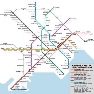
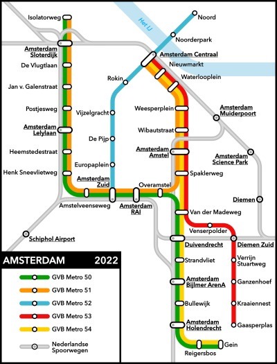
This is a first for me, but I am officially opening for commissions! If you have an idea for a schematic transit map you want me to make, now’s the perfect chance.
My rates for the moment are a base fee of $20, plus $10 for each route. So for example, that’s $30 for a single line, $50 for three lines, or $120 for ten lines. Branching, short routes, and overly complicated networks are case by case. Simple backgrounds and legends are included if desired.
Here are a few examples of my work!

19 notes
·
View notes
Note
why do you hate portland
I assume this is probably a troll question, but I am *fascinated* as to what led it to be asked in the first place.
6 notes
·
View notes
Note
Salt lake citizen here, what do you think about the UTA Trax System?
I’ve never had the chance to ride it, but I definitely respect that it doesn’t charge fares in the downtown zone! I also like how it connects to the FrontRunner at three different stations—a lot of comparable systems have just one commuter rail connection or even none. (Relatedly, the FrontRunner corridor is kind of a perfect fit for commuter rail and I’m a fan of how it was implemented.) Plus, a relatively new vehicle fleet is nothing to scoff at, even if some older trains are still in the mix for now.
While fifteen-minute headways are disappointingly low, from the schedules I’m seeing it looks like they’re synced up so that there’s never more than a seven-minute wait in the segment shared by all three lines. They seem to be spaced out so that the shared Blue/Green segment has nearly-even spacing between southbound trains while the shared Blue/Red segment has nearly-even spacing between the northbound trains. That sounded good until I realized that there’d be up to eleven-minute waits on those two segments in the reverse directions. I’d probably fix this by switching the endpoints of the Red and Green lines, so that the same two lines would cover the whole Temple to Murray route, while the third would run from the university to West Valley.
I was ready to be disappointed by the S-Line, but honestly the scheduling looks reasonable. The fifteen-minute headways sync up with the light rail, and there’s a direct transfer to/from all three lines with integrated fares. Plus, it looks like it has a dedicated lane for most if not all of the route? That’s the right way to do an integrated streetcar, even if the route is annoyingly short.
Which I guess brings me to the coverage question. Despite the good things I’ve listed so far, it’s still a light rail system in a large American city, so it’s obviously gonna have huge gaps in the network. The north/south coverage is pretty good (and the routing could have been a lot slower), but the east/west coverage is so bad that places like Magna Kearns and Holladay and Cottonwood Heights can be in the realm of five to ten miles from the nearest station. Bus connections don’t cut it; the region seriously needs expanded rail coverage. I could say that about anywhere in the country, of course, but it just goes to show that Salt Lake City can’t escape the ultimate weakness of American transit.
My ratings:
Fares: 7/10
Transfers: 9/10
Schedule: 6/10
Vehicles: 8/10
Routings: 8/10
Coverage: 3/10
Overall: 7/10
9 notes
·
View notes
Photo
I almost completely forgot about this post I made seven years ago, but I'm not sure Metra did. They just proposed these fare zones for 2024, and it's kind of striking just how similar this is.
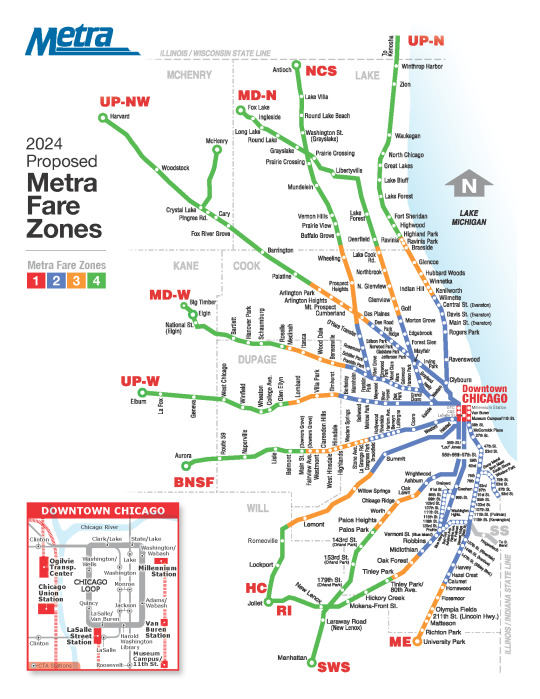
I have to say, though, I didn't expect them to lower fares *nearly* as much as they're doing. I live in New York now and I am so jealous of that $3.75 intermediate fare. And since that matches the Zone 2 fare, well…that means that someone in Zone 2 could get to literally any station on the system for $3.75.
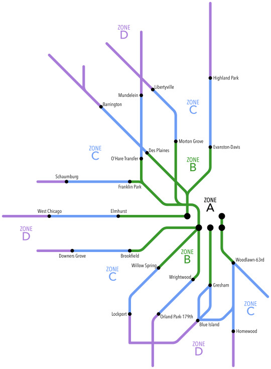
Rumors have it that Chicago’s Metra plans to completely rework its fare system in the near future. So I put together a few ideas that could hopefully steer them in the right direction.
Firstly, the number of zones needs to be reduced dramatically. The current system of twelve or thirteen zones (depending on how you count) is WAY too complicated, and unnecessarily so. The number of zones could ideally be reduced to three or four. (A modification could count the five downtown stations as their own zone, so that trips downtown would be subject to an increased fare.)
Secondly, zones should be divided at major stations, which can count as part of each zone. For instance, on the map above, the Woodlawn-63rd station would be counted as in both Zone B and Zone D. This encourages travel in both directions from those stations, and in some cases (such as that of Woodlawn-63rd) makes it easier to transfer from one route to another.
Thirdly, fares should be determined simply by the number of zones crossed. A base fare could be set, such as $2.50, and an additional fee, such as $2.00, could be added based on how many zones are crossed. Given these example prices, a trip from Zone D to Zone B, covering three zones, would cost $8.50—still comparable to current prices for that region. Of course, prices would have to be carefully optimized to ensure no fares change too dramatically from their current values.
And finally, the system must be designed with transfers in mind. The example given here could easily be adjusted for trips between any two stations with transfers. Consider, for instance, a trip from Woodstock to Winnetka. The train from Woodstock begins in zone D and ends at Clybourn in zone B. The train from Clybourn ends in zone C. Since zone C was entered twice, it is counted as a four-zone trip (D-C-B-C), and under the example prices would have a fare of $10.50. Tickets could be designed to print multiple trips, and could print a space for conductors to punch on two different trains.
These ideas clearly show that a simpler fare structure for Metra is possible. When reworking the fares, Metra should take care to make sure simplicity takes priority.
P. S. No, I don’t just post Chicago things. Stay tuned in the coming weeks for more!
23 notes
·
View notes
Text


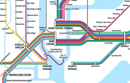
View in full resolution
After almost six months of work, I'm proud to finally present my integrated commuter rail map of New York City and Philadelphia!
Showing five different commuter rail systems (CT Rail, Metro-North, LIRR, NJ Transit, and SEPTA), this map depicts everywhere a passenger can get to by train from NYC or Philadelphia without using Amtrak.
This is by far the most complicated map I've ever made, but I'm incredibly happy with the result! I'm planning to write some notes on the process of making this, but for now, I'm just proud that it's finally done.
#trains#transit#maps#amtrak#nyc#philadelphia#ct rail#mta#metro-north#lirr#nj transit#septa#new york#new jersey#connecticut#pennsylvania
329 notes
·
View notes
Text
This actually reminds me of another interesting thing I’d been wanting to talk about, because from my recollection of the timetables I believe there’s technically one train from the Raritan Valley Line that continues past Penn to Hoboken, and I’m pretty sure it’s the only one in either direction. It took a while to figure out whether to show it, but I eventually found some consistent logic for when to show alternate terminals. There are a lot of routes that do that, after all, and showing every single service deviation would clutter the map.
A few routes have semi-regular service into multiple terminals. On LIRR, that’d be Port Washington, inner Port Jefferson, Ronkonkoma, and Babylon, while on NJT that’d be Morristown and Montclair-Boonton, which have both peak and off-peak service into Hoboken, even if it is limited. All of those should definitely be shown as branches, ‘cause it’s part of the regular service pattern.
Then there are the diesel routes that typically require a transfer to continue into NYC but send a few peak-hour trips the rest of the way. On LIRR that’s Montauk, Oyster Bay, and Port Jefferson; on Metro-North that’s Danbury and the outer Harlem Line; on NJ Transit that’s the outer North Jersey Coast Line. These are better described as service extensions rather than as service deviations, since they still serve all their regular stations. And choosing not to include them would mean Hunterspoint Av and Long Island City wouldn’t appear on the map at all, since they’re served exclusively by extended peak-hour diesel trains. So I included these and marked them as irregular service. I didn’t include the
The remaining service variations are basically all just trains that follow the route’s usual service pattern but just go to a different endpoint. And these are all quite chaotic without any regularity to them—with three exceptions, all on the LIRR. The Babylon Branch sends three peak round-trips into Atlantic Terminal, and each of them only serves stops as far out as Freeport; this service is consistent enough to warrant being shown with a separate line. (After all, I had a line for the two daily outer-NJCL trips into Penn!) The second consistent exception is that for some reason the Far Rockaway and Long Beach branches switch their Manhattan terminals on weekends. Since this map is based mostly on weekday service patterns (with a number of route segments that don’t even operate on weekends), I didn’t show that. And the third exception is a single Friday train from Greenport that’s extended past Ronkonkoma to Jamaica, which only goes one way and is even more obscure than most of the weird peak-hour terminal switches. (And it doesn’t even look like it’s running at the moment, though I’m not sure.)
And so really, the map wouldn’t gain much from adding any of the service variations other than the diesel-route extensions and the Babylon Branch service to Atlantic Terminal. Sure, they’re connections that are technically possible, but only at very specific times—and they’re something that wouldn’t be useful to basically any user of the map.
A project I’ve been working on for several months is now almost finished :)
330 notes
·
View notes
Text
It is and it’s absolutely ridiculous. I’ve seen a few combined maps that include it, but for this map I’m interpreting it as not commuter rail because I don’t want it to be and because it’d be really hard to fit it on the map!
(I’m also probably gonna remove the Hoboken ferries, with the argument that they aren’t timed to connect with trains. It feels weird to have those when PATH is the more common transfer.)
A project I’ve been working on for several months is now almost finished :)
330 notes
·
View notes
Text
The NYC Subway has set an accessibility goal of ensuring that no station is more than two stops away from the nearest accessible station. Seems like a noble goal, but how much of an investment does that actually involve? Let’s take a look at the current gaps in the network.
The 1 train has an eleven-stop gap (Dyckman St to 96 St) and a nine-stop gap (Penn Station to Chambers St). 3 new accessible stations would be needed.
The 3 train has seven non-accessible stations beyond Utica Av; 1 new accessible station would be needed in addition to the planned upgrades at Junius St.
The 4 train has four non-accessible stations beyond Fordham Rd, but this gap will be filled by planned upgrades at Mosholu Pkwy.
The 6 train has an eleven-stop gap (Pelham Bay Park to Hunts Point Av) and a seven-stop gap (Hunts Point Av to 125 St); 2 new accessible stations would be needed.
The 7 train has a six-stop gap (Court Sq to Woodside); 1 new accessible station would be needed. (Upgrading Queensboro Plaza would also fill a gap on the N and W trains.)
The A train has a seven-stop gap (Euclid Av to Lefferts Blvd) that will be filled by planned upgrades at Rockaway Blvd.
The C train has an eight-stop gap (125 St to 59 St) and a seven-stop gap (Utica Av to Euclid Av); 2 new accessible stations would be needed.
The D train has a seven-stop gap (Kingsbridge Rd to Yankee Stadium) and a six-stop gap (Atlantic Av to 62 St); 2 new accessible stations would be needed. (Upgrading 36 St would also fill a gap on the R train.)
The F Train has a twelve-stop gap (Church Av to Coney Island); 1 new accessible station would be needed in addition to the planned upgrades at Kings Hwy.
The G train has an eighteen-stop gap between Jay St MetroTech and Church Av; 3 new accessible stations would be needed. (One of these would also fill a gap on the F train.)
The J train and Z train have a record-holding nineteen-station gap between Flushing Av and Sutphin Blvd. 3 new accessible stations would be needed.
The L train has an eight-station gap (Bedford Av to Myrtle—Wyckoff Avs); 1 new accessible station would be needed.
The M train and R train have two six-station gaps (on either side of Roosevelt Av); 2 new accessible stations would be needed, including the planned upgrades at Woodhaven Blvd.
The N train has a seven-station gap (New Utrecht Av to Coney Island) and an eight-station gap (Astoria Blvd to 57 St); 2 new accessible stations would be needed. (Upgrading Queensboro Plaza would also fill a gap on the 7 train.)
The Q train has a six-station gap (Prospect Park to Avenue H) and a seven-station gap (Kings Hwy to Coney Island) that will be filled respectively by planned upgrades at Church Av and Sheepshead Bay.
The R train has an eight-station gap (Atlantic Av to 59 St); 1 new accessible station would be needed. (Upgrading 36 St would also fill a gap on the D train.)
In total?
The stated goal could be met with 22 new accessible stations beyond what’s already planned. That’d bring the total number of accessible stations on the system from 143 (30% of the system) to 165 (35% of the system).
And that’s not particularly impressive. Ultimately, “no station will be more than two stops away from an accessible station” might sound like a lot but honestly isn’t all that much of an improvement on the status quo. The MTA needs to be held to a higher standard for accessibility.
17 notes
·
View notes
Note
have you ever done any "what if?" type maps for atlanta? despite having a metro area population of 6 million (roughly on par with DC, Philly, or Miami) we have a notoriously horrible light rail / subway network :(
Oh I haven't! Unless you count a map I made back in 2014 or so that I doubt I'd be able to find—and that was just showing a proposed line in addition to the existing MARTA network. That sounds like it could be a fun project; I can't promise to do it but I'll keep it in mind!
4 notes
·
View notes
Text
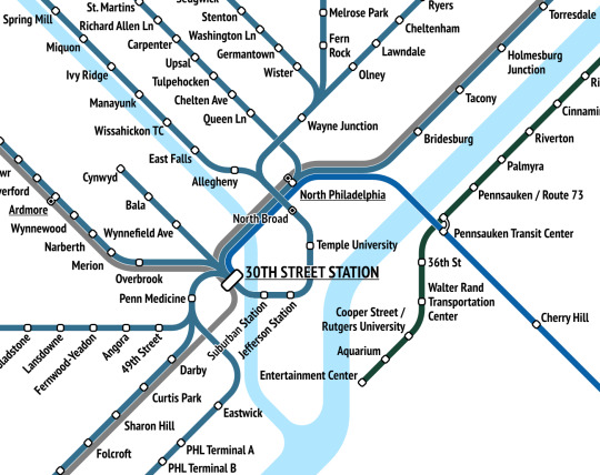
I wasn't sure if I'd be able to coherently include Philadelphia. That question has now been answered.
A project I’ve been working on for several months is now almost finished :)
330 notes
·
View notes
Text
A project I’ve been working on for several months is now almost finished :)
330 notes
·
View notes
Text
An update on my Redbubble store
In protest of Redbubble’s new absurd account fees, I’m going to be shutting down all orders from my Redbubble store on April 30th.
For context, Redbubble has added a new “account fee” to all standard accounts. What that means in practice is that they’re gonna be taking up to 50 percent of artists’ monthly earnings on the site. They’re justifying this by saying that artists can always set their prices as high or as low as they want above the manufacturing fee, but this means artists have to dramatically hike prices in order to make the same margins, which obviously lowers the number of sales. So ultimately, Redbubble’s doing this as a way to raise their prices while letting the artists take the blame.
If you want to order prints/mugs/shirts/anything of any of my maps before this new awful policy goes into effect, this is the last chance. Here’s the link:
20 notes
·
View notes
Note
Can You Update Your Pittsburgh Transit Map By Including The PATrain Commuter Rail With Suburban Stops In Versaille,Port Vue Liberty,Mckeesport,Braddock And Hazelwood And Have The Terminal In Downtown Be Penn,Remove The Red Line Rush Hours Only To South Hills Village Cause It Now Goes There 24/7,Adding The Silver Line That Follows The Blue Line Before Taking Over Service To Library And Have Said Line Go To Penn Station Instead Of Allegheny?
While I do admit my Pittsburgh map is out of date, it looks like some of these requests are for a personal fantasy map rather than the actual current network? That sort of thing would probably be more appropriate as commission work rather than as a request.
I don’t know if I’m gonna be updating my Pittsburgh map anytime soon, but I might if there’s more demand for it!
4 notes
·
View notes
Note
Oh huh, I'm seeing now that there's also one daily Al Atlas round trip! Seems like it runs through from Kénitra, but I'm having trouble figuring it out because the Al Atlas timetables on the ONCF site are broken.
there is a train directly from casa port to el jadida
Yeah! That one's shown in orange on my Morocco map since it's a TNR line.
4 notes
·
View notes
Note
Hello How do i travel by metro from Muhammad V airport to see the city center, Hassan 2 Mosque, , Rick's cafe, the bazaars and other important central city landmarks, have only one day in Casablanca, thanks
Hello! I’ve never been to Casablanca, so I’m really not the best person to ask. All I can say is that ONCF runs trains from the airport to the city center every hour, and that the city has a couple tram lines that can be used for local travel. I’ll admit that seems like a very busy itinerary for just one day, so good luck!
3 notes
·
View notes
Note
there is a train directly from casa port to el jadida
Yeah! That one's shown in orange on my Morocco map since it's a TNR line.
4 notes
·
View notes