theearthaccordingtodavid
David Garcia
geographer.planner.cartographer
24 posts
Don't wanna be here? Send us removal request.
Last Seen Blogs

nicenormalguy
educational family friendly blog


saimondesign
Saimon
iamthebenshaw
YEAH!

clamglass8
The Journaling of Patton 974
Photo

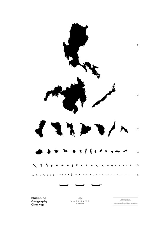
Tonight’s mapcraft. :)
(free, open, and accessible geospatial data from: philgis.org)
#mapcraft#geographer#philippines#philippine geography checkup#geospatial#map art#cartography#GIS#geographic information system#FOSS#opensource#snellen#maps
2 notes
·
View notes
Photo

100 years of earthquakes in the Philippines, according to magnitude. To be more precise, the record from USGS is 115 years hehe. Oh, Philippines, you’re beautiful and dangerous. :)
#earthquake#philippines#west valley fault#valley fault#marikina fault line#shakedrill#shake drill#metro manila shakedrill#geospatial#GIS#cartography#geology#geomorphology#pacific ring of fire#historical earthquakes#USGS#PHIVOLCS#geography#open data#FOSS
3 notes
·
View notes
Photo
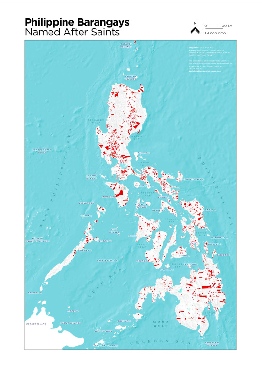
Place name basics in the Philippines:
1. Roads/streets/boulevards/avenues - surname of political dynasty
2. Barangays - saints (san, santo, santa)
In this map, I highlighted such barangays in red.
Which regions have the most barangays with saints as names? Which regions don’t? How did this happen? Why? :)
#philippines#place names#nominal location#geography#philippine geography#place making#place naming#GIS#geospatial#maps#philippine archipelago
1 note
·
View note
Photo

Mayon Volcano in Albay, Philippines has the planet’s perfect cone. This active stratovolcano is shared by surrounding towns, like in a sliced pie. I hope that this map I created emphasizes the geomorphological beauty of this Philippine national heritage.
Three major urban agglomerations - Legaspi, Tabaco, and Ligao - surround the volcano and are connected by national roads in a triangle. But settlements are prohibited from being located inside the six-kilometer danger zone set by the national government. This is because the threat of pyroclastic flows is always imminent due to the numerous rivers that radiate from the center.
Mayon, you’re beautiful and dangerous. :)
*By the way, a map doesn’t have to be always oriented with the traditional “north-up”. :)
**On a personal note, fieldwork, mapping, and urban planning experiences in Tabaco (2011) and Ligao (2013) really shaped my geographic thinking. I should thank my UP Geog colleagues and student for letting me be part of the team. I carried the Albay experiences with me when I left UP to deploy Guiuan, Ormoc, and Tacloban because of Super Typhoon Haiyan.
#gis#geospatial#cartography#geographic information system#mayon#volcano#philippines#geomorphology#geography#philippine geography#map design#topographic#relief#hilshade#albay#pacific ring of fire#pacific ring#mayon volcano natural park#mayon volcano national park#itsmorefuninthephilippines#map#maps
18 notes
·
View notes
Photo

Mount Bulusan and surrounding settlements. One of the most active volcanoes in the Philippines, Bulusan recently erupted in early May 2015.
#geospatial#gis#cartography#geography#geomorphology#bulusan#sorsogon#volcano#geology#phreatic#philippines#volcanic eruption#bicol#stratovolcano
60 notes
·
View notes
Text
Liberating Public Geospatial Data in the Philippines
No to monopoly of geospatial data that belongs to the national patrimony.
Aside from the paranoia regarding the forthcoming NCR earthquake and the valley fault, there is a related paranoia happening - the paranoia on how to release the fault and earthquake data to the public (pdf, shapefile, webmap, printed, etc.).
We have to look at the story of Project NOAH for inspiration for the solution to the situation. For decades, other mapping agencies have always required letters, payments, and whatsoever redtape/excuse for not releasing data that belongs to the public and taxpayers. In contrast, what NOAH did was to liberate the geospatial data by doing the following:
1. Rendering the hard and soft copies of maps onto a webmap (and apps);
2. Releasing the open-format geospatial data (read: shapefiles) to professionals (mappers, planners, dev workers, etc.) who need to serve the people through their work as soon as possible FOR FREE and without much formality; and
3. By actually going to cities and municipalities to discuss, validate, and disseminate the maps in popular formats - printed in tarpaulin! smile emoticon
Therefore, what the other agencies failed to do for decades, the NOAH team was able to accomplish in a few years.
Here's another true story: after Super Typhoon Yolanda, because NOAH and other geospatial data groups released the data in open formats (read: shapefile), we, humanitarians, were able to respond more accurately to the postdisaster situation. Our mapping teams were more able to validate the maps. It was easier to bring the map to the people and improving the map with them through joint fieldwork and community validation.
(What we just did in return was to give credit to whom it was due through metadata, logo placements, and reference lists).
Now, the people of Barangay Suluan in Guiuan, Eastern Samar have their own set of community-validated geohazard and base maps. They are now using it for evacuations and DRRM planning. Since they don't have an internet connection (even mobile phone signal! no printers!), they don't have to go to a website, Fort Bonifacio, or C.P. Garcia Ave. just to get the map.

Figure 1. A geohazard map of Guiuan. This is a work of the mapping team sponsored by UN-HABITAT, UNICEF, and the Local Government Unit of Guiuan, Eastern Samar. Data credits indicated in the logos.
But why would we require a disaster for data to be released openly, freely, and without much formality?
Bakit kailangang mangyari muna ang trahedya bago ilabas ang datos?
Dear government mapper/data holder, you do not "own" the data. We are but custodians - stewards - of the people's data. Since we are mere stewards of the people's data, we are supposed to release the data in most accurate, appropriate, and accessible format in the least possible cost and time. Please, don't lock the map data away in "ivory towers."
If the people can't go get the data, then bring the data to the people.
Again, no to data monopoly of geospatial information that belongs to the national patrimony. Citizens, let's demand more free and open geospatial data.
(opinions are personal)
#geospatial#cartography#gis#geohazards#geomorphology#natural hazards#open data#FOSS#open source#guiuan#haiyan#eastern samar#fault#earthquake#metro manila
16 notes
·
View notes
Text
Dear Mapper and Map User, Mapping is a Craft

Mapping is a craft. Making a map is doing a work of art.
It is as if you're making beer, coffee, or chocolate. You can read manuals and use high-tech appliances but the best maps are those made thoughtfully; they are well-used. A well-crafted map is very much like your favorite fiction book: folded, torn, smudged, worn out, and (probably) smuggled - but well-loved.
Why so? Using a Geographical Information Systems (GIS) software certainly boosts the creative process; yet there is no substitute for a well-thought cartographic piece. I tell you - two persons with the same software and data set can make two very different maps.
How can we craft a well-loved map?
As much as possible, the details of the map should be filled with your memories of the place. This is because visiting the place infuses a secret element: the experience of the place. Personally experiencing a place creates a special memory bank - the mind map. Afterwards, it won't be difficult to draw thoughts and emotions from that bank of geographic details. These deposits set your map apart from any other product of desktop software.
Make sure that the names and boundaries of places are correct as these
are held dear by the residents. History is full of mapmakers who, with whatever intention, modified names and disregarded the memories associated with the name. This happened when "Sasmuan" in Pampanga became "Sexmoan" through the alleged alteration by a foreign mapmaker. The work has to convey not only emotion but also thought through accurate and locally-sourced data. This gives justice to people who live in the real space that we're putting into abstract.
There are times when you don't have to prioritize boundaries. Place rivers over borderlines to remind people that we don't have to try too hard to pixellate an otherwise fractal and transboundary world.
Whether printing on paper or projecting on screen, you will enrich the mapmaking through such simple steps.
Draft becomes craft.
Mapping is a craft. Like in a photograph, the crispiness or haziness of the resolution of the map matters; the scale gives the impression of tightness or wideness. Like in a sculpture, the undulations of the relief provide the feeling as if your touching the landscape. Like in a painting, the tone and hues should elicit feeling. Like in a novel, the image has to convey a story, particularly through typography. Like in a delicacy, the appearance should leave an aftertaste through an afterthought.
Eventually, the medium becomes the message; the jpeg file becomes something that you can't buy off the bookstore shelf.
Once you consume it, the well-crafted map enters the consciousness and engages the taste and mind; the landscape becomes part of the mindscape.
It is only through crafting - not just drafting - that the map gains potency for making good decisions, managing resources, and saving lives.
---
Prologue:
Therefore, dear map user, please don't have the mapper rush the map. Yet there's a warning, dear mapper: please don't make the map user wait too long, or else.
This didn't have to be erudite, esoteric, and terrifyingly long but it's #sentisabado haha.
Credits: the map is part of a continuing work for the Guiuan LGU and UN-HABITAT. The geohazard data is from Project NOAH and JICA. The road data is from OSM. The island boundary data is from Google Earth. :)
#cartography#mapping#gis#relief#hillshade#art#geographic#information#systems#geography#guiuan#suluan#philippines#islands#pacific#leyte gulf#guiuan marine reserve
18 notes
·
View notes
Photo
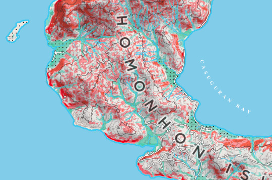
Tonight in mapping: geohazards of Homonhon Island. Red areas are landslide prone; green areas are flood-prone. The dotted areas are prone to liquefaction.
In 1521, Ferdinand Magellan first arrived in the Philippines by stepping on Homonhon Island. It is claimed that the first mass on Philippine soil was held here.
1 note
·
View note
Text
Here's to the Explorers
20 July 2014
45 years ago, Apollo 11 landed on the moon. 45 years later, while much of the Earth is yet to be explored the human race is looking forward to the deep understanding of all possible worlds.
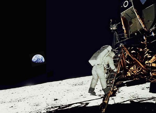
Explorers, such as Neil Armstrong, push the boundary of the unknown. They build on the experiences of the explorers who came before them. In pushing and redrawing boundaries, their impact on places, both pioneering and tragic, thrust history forward.
Here's to the geographers, cartographers, traders, navigators, mountaineers, expeditionists, "marsographers", "jupitergraphers", and all the explorers who are yet to be born.
Here's to the explorers, who will never be satisfied of being here.
---
Image credit to:
http://newswatch.nationalgeographic.com/files/2012/08/Apollo-11-on-the-moon-picture-950x690.jpg
#july 20#apollo 11#one small step for man#giant leap for mankind#apollo 11 45th anniversary#explorer#geographer#outerspace#moon landing#lunar landing
2 notes
·
View notes
Text
Much Ado about Swirls, Storms, and Stars
11 July 2014. Guiuan, Eastern Samar. Updated 13 July 2014
After I filled the laundry basin by a hand pump, I poured a white fabric conditioner. The flow of the fabric conditioner in the water formed a swirl.
This was the end of a really busy week. I had to help in making sure that what JICA, Cordaid, UNICEF, and other humanitarian partners do in my field site harmoniously happen. Hence, I rushed to try to finish the overdue laundry while the moonshine and the stars lit the midnight sky.
This is the context: I have left my teaching job in UP Diliman to temporarily migrate here in Guiuan, Eastern Samar. This town was where Super Typhoon Yolanda (international name: Haiyan) first struck the Philippines last November 2013. As an expert on mission for the United Nations, I have to help conceptualize, organize, and mobilize a number of rehabilitation and recovery plans, programs, and projects. Included in such gargantuan task for the 40,000+ strong population is making sure that I took my laundry seriously; otherwise it shall be an impediment to the accomplishment of my mandate. Haha
Upon focusing on the chemical swirl, I realized that the same forces that operate in the galaxies operate on the puny mixture in my laundry basin. I tell you; this is one "Kafka on the Shore" moment. The sensation was better than twenty iced coffee cups (no, iced coffee is definitely better; I miss the city coffee; but I miss Vega more; David, can you please stop the side comments and the excessive use of semicolons?).
During that moment, I had to pause to look up to the clear night sky. Soon after my mind had a glimpse of how the laundry basin, the purpose of my United Nations mission, and the celestial bodies were connected.
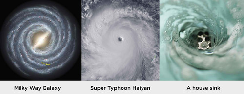
What a lesson on fractals! I just observed similar patterns that manifest in three scales: the galactic, atmospheric, and domestic. Read this following word with an Australian accent: Amazing (ammaaaaaiiiizzzeeeeng)!
But I warned myself that Elon Musk told in TED that most people spend their lives thinking using analogies; and that was an unpleasant idea sometimes. This means that there are people using engineering concepts in the social sciences; business professionals adopting practices from religions; and quantum physics being used in religious and therapeutic circles (which is very dumbing and false). Elon Musk implied that the practice of abusing analogies was something to be avoided as much as possible.
Therefore, the moment - when I realized that the swirl of the fabric conditioner, the circulation pattern of ST Yolanda, and the structure of the Milky Way were all essentially connected - was existential but quite corny.
In his TED talk, Musk, the CEO of Tesla and SpaceX, emphasized that there are only a few who break the existential frontiers by attempting to play with and grasp the fundamental notions on how the universe works.
For now, I can wallow in this question: How can we fully utilize the principles of physics and fundamental laws of the universe in planning and reviving the towns ravaged by geophysical disasters? What is the vanguard role of science in "building back better?"
Oh, the stars. They remind me of Vega. Cheeseballs.
Check out "A Sky Full of Stars" by Coldplay, who just released the song in their new album, "Ghost Stories"
http://www.youtube.com/watch?v=VPRjCeoBqrI
"You're a sky full of stars. Such a heavenly view. I give my heart to you."
---
Photo credits to:
Milky Way Galaxy: http://www.space.com/14249-milkyway-galaxy-photos.html
Super Typhoon Haiyan: http://cdn.theatlantic.com/static/infocus/haiyan111113/s_h02_87265805.jpg
A house sink: http://images.iop.org/objects/phw/world/20/2/4/PWcri1_02-07.jpg
1 note
·
View note
Photo

Guiuan in Eastern Samar is the first town to be hit by Typhoon Haiyan (Yolanda) last November 2013.
#haiyan#yolanda#supertyphoon#supertyphoonyolanda#supertyphoon haiyan#topographic map#homonhon#manicani#suluan#calicoan#calicoan surfing#philippines#relief map#relief map eastern samar
0 notes
Photo

This is a simple relief map of barangays in Camiguin in the Philippines
#camiguin#philippines#itsmorefuninthephilippines#philippine islands#tropical island#GIS#GIS philippines#cartography#geomorphology
2 notes
·
View notes
Photo

Recently, I created a topographic map of Mount Apo National Park in the Philippines. Mount Apo is the highest mountain in the archipelago. Terrain data was extracted from a Digital Elevation Model (DEM) in philgis.org.
#mount apo#apo national park#davao#philgis#dem#topography#philippines#mindanao#contours#topographic map
2 notes
·
View notes
Text
Nelson Mandela Lived to Tear Down Walls
I will always remember the personal lessons from Nelson Mandela's life. 11 February 1990: It was the day when I was born into the world. On the other side of the globe, Nelson Mandela was freed after decades in prison. Whereas the Berlin wall was torn down months before, for many his freedom meant the end of apartheid in South Africa. Apartheid, meaning "separateness" in one of their local languages, was a situation wherein people were judged and policed according to their physical appearance (color, skin, etc.).
Apartheid was geographical. Apartheid policies back then meant that there were different and separate schools, bathrooms, and other spaces for whites, blacks, indians, red-haireds, etc. The spatial separation meant selective employment, income inequalities, abuse, and discrimination. Having a different skin color meant lesser housing, low-paying jobs, and physical violence.
Nelson Mandela fought to tear down the wall and end the separateness.
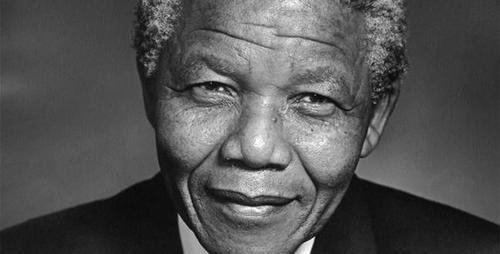
Yet in both our minds and geographies, the walls still stand and persist today. Rich and poor; ugly and beautiful; formal and informal settler; citizen and indigenous; saved and unbeliever; and, interestingly, UP and others. More often than not, we take these dualisms as normal and do both soft and extreme measures to enforce and reproduce the idea. These are the apartheids of today.
What are the walls we should question and, possibly, demolish today?
-----------
photo credit to: http://guardianlv.com/wp-content/uploads/2013/10/Nelson-Mandela%E2%80%99s-Top-Five-Contributions-to-Humanity.jpg
0 notes
Text
Nagging Questions on Disasters in the Philippines
Good day to you. Typhoon Yolanda just struck the Philippines. In response, over the past few days I have been asking the following:
1. What will happen if a 7.x magnitude earthquake struck Metro Manila and a typhoon soon follows after?
2. Are we prepared for such eventuality?
3. What are the steps towards the planning and general preparations for such events?
4. How do we make more people understand the disaster risk formula [risk = (hazard x exposure x vulnerability)adaptive capacity]?
5. Upon understanding the disaster risk formula, how do we translate our solutions into the physical landscape and human systems?
#typhoon#yolanda#disaster#philippines#disaster risk#disaster risk reduction#disaster risk reduction and management
2 notes
·
View notes
Text
Geodiversity
GEODIVERSITY. This term is quite a good word today to describe diversity in the earth sciences, particularly geomorphology.
Genealogy of Geodiversity
To understand geodiversity, let us look at its genealogy - the history of the idea. How did the term come into existence? In my opinion, it started with "biodiversity". In the field of biology and its applications in managing the "natural" environment, the similar term in use is "biodiversity." It simply means the level of variation in the species in a specified area. The number of various species in a forest is "forest biodiversity"; in a coastal area, "coastal biodiversity"; in an urban system, "urban biodiversity."
Biodiversity thereafter became a bigger (and more vague) word. The term biodiversity was then used to mean larger things like the "beauty of nature," the fragility of ecosystems, and something for communities to cash in. Just think of that scene in the Lion King movie: all sorts of circus animals singing "The Circle of Life."
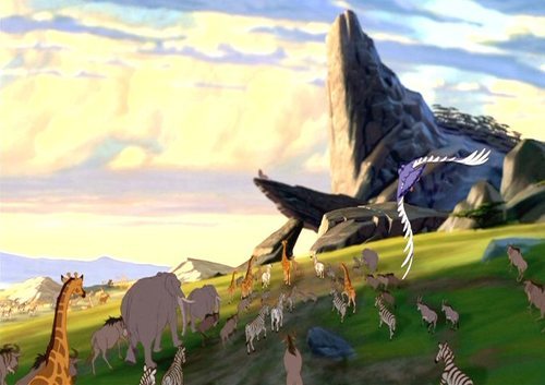
Rafiki raises Simba. Nants Ingonyama bagithi Baba! Biodiversity!
Biodiversity then became the seed for the idea of geodiversity. We need a term for describing those moments when we are in awe of landscapes and seascapes. A case in point: Calaguas Islands, which are located off the coast of Camarines Norte, Philippines.
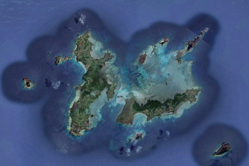
This is not your ordinary group of Pacific islands.
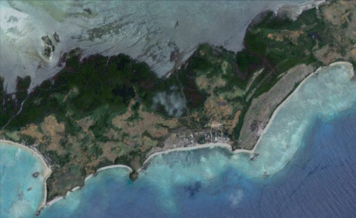
It is famous for its long white beaches, the one to the right is called "Mahabang Buhangin," which literally translates into "Long Beach" and is claimed to be longer than Boracay's longest white beach. Rolling hills are similar those in the Batanes Islands, Philippines.

It houses small but precious communities. Look at the delta at the center of the image. Even the delta is white!

This lake in one of the big islands connotes good groundwater supply.
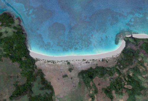
Unspoiled, turquoise, and white beaches! Pockets of woodlands!

Look at these white depositional formations. Imagine yourself running around these shifting sands of white awesome
To understand what I mean in this case, please read the sketchy formula below:
Islands + islets + streams + delta + woodland pockets + lake + mangrove areas + large and long white beaches + = geodiversity
The field is open for those who want into delve in these aspects of earth sciences. Maybe, the term could be used as an entry point into something beautiful.
The Philippines is one big place for the application of the concept, as seen in the recent "It's More Fun in the Philippines" campaign by the Department of Tourism. Also, I place my bet that any country with high biodiversity, such as the Philippines, tends to have higher levels of geodiversity.
But how will the idea actually function in everyday life?
Crafting the Geodiversity Bandwagon
Eventually, the idea of "geodiversity" will connote beauty and will be used to commodify geomorphic systems. "Geodiverse" landscapes may be proclaimed by the state through the government. Then, the Department of Tourism might catch the idea and use it for a campaign. I bet there shall be a Media Forum on Philippine Geodiversity, which will then evolved into a Philippine National Conference on Geodiversity. The National Action Plan for Philippine Geodiversity will then follow. Local Government Units will follow suit and use the term to have local projects on geodiversity tourism and geodiversity conservation. It may take some time, but the term will find its way into land use and development plans.
On the side, there shall be photo contests on Philippine geodiversity; a national geodiversity youth conference; a facebook group; and celebrity endorsement. Maybe, a geodiversity club/network will be started.
If we're lucky, then we will have a Republic Act on Geodiversity.
Finally, a Geodiversity bandwagon. Just one good idea and it becomes reality. It will work like "Inception."
That sequence is what happened to other ideas such as "disaster risk reduction", "climate change adaptation", "green urbanism", and "biodiversity". Will the use of the idea help in creating spaces where poverty is less possible?
I wonder, what if we start planting the idea of "geodiversity" into the mainstream thought process in the Philippines?
Credits
Circle of Life Scene http://media.desura.com/images/members/1/36/35997/priderock.jpg
Calaguas Islands screenshots are from Google Earth
#geodiversity#biodiversity#geomorphology#itsmorefuninthephilippines#philippinebeach#whitebeach#philippine white beach#tourism#tourism philippines#geotourism#geological diversity#philippine islands#tropical beach#beach tourism
1 note
·
View note
Photo
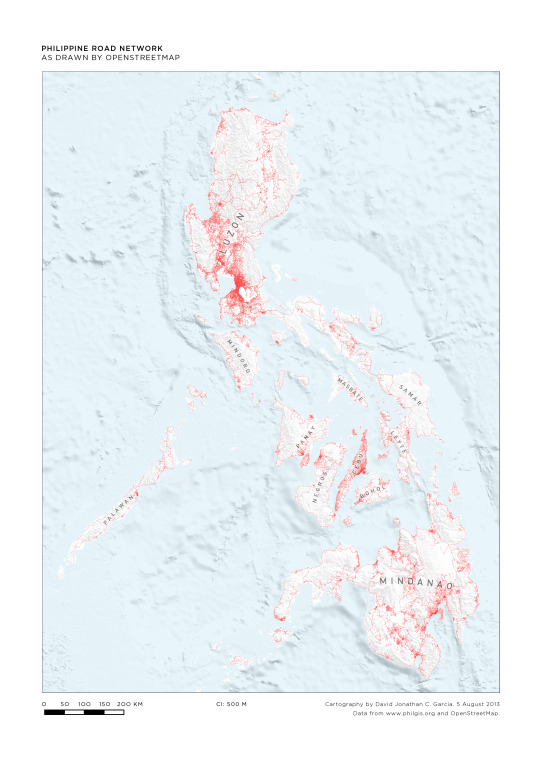
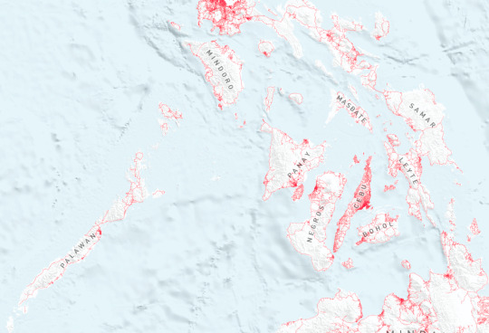
The spatial distribution of roads indicate the level of development and is a function of topography and population. Through the map, we can have clues on where people actually are across the Philippine archipelago.
0 notes