
texasalmanac
Texas Almanac
The Texas Almanac is a collection of maps, statistics, and facts all about the state of Texas. Since 1857!
11 posts
Don't wanna be here? Send us removal request.
Last Seen Blogs

loneliness-suffering
Hello!

ansh-air-ambulance
Ansh Air Ambulance


amber201
Tack, Malin❤️

petals2fish
The Tortured Petals Department
Photo

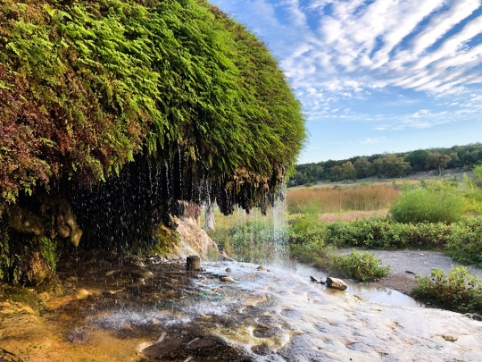
Lake Ray Roberts
#texas #texasphotography #texasskies #texaslakes #nature #raw_sunset #raw_skies #sunset_pics #texassunset #scenicphotography #sky_captures #scape_captures #visittexas #naturephotography #raw_landscape #raw_usa #raw_rural #raw_travel #lake #travelphotography #landscapephotography #nature_perfection #nature_brilliance #naturebeauty #naturelovers #nature #raw_travel #scenicview #nature_lovers #traveltexas (at Lake Ray Roberts)
https://www.instagram.com/p/CQep_VnrQEU/?utm_medium=tumblr
5 notes
·
View notes
Photo

An old pickup truck rusts outside of Graham Pharmacy, a locally-owned business in Midland, Texas. There is a full gift shop and cafe inside.
Attribution-NonCommercial 4.0 International (CC BY-NC 4.0) Creative Commons license.
You might be wondering what this license means. Well, if you need to use our photography for something that doesn't involve profit--say, you're a nonprofit, or a student doing a book report, or someone editing art for the fun of it--you can take these images and use them. You can also modify them as much as you want.
The reason for this is simple: because the Texas Almanac is a non-profit, operating on a tight budget, we utilize creative commons licenses and public domain material all of the time. We're so grateful for other people's help that it would be hypocritical not to offer the same help to others.
Coincidentally, if you think one of your photos would fit well in the Almanac, send us a note! We will trade you a copy of the newest Almanac or give you $25, whichever you prefer.
Shot by Rachel Kaelin, Associate Editor of the Texas Almanac. 2022.06.01
0 notes
Text
Where in Texas is this? It’s beautiful!


» magic is always pushing and drawing and making things out of nothing. everything is made out of magic, leaves and trees, flowers and birds, badgers and foxes and squirrels and people. so it must be all around us.
―frances hodgson burnett
50 notes
·
View notes
Photo

Big-Tex, Dallas State Fair, 1961
167 notes
·
View notes
Photo

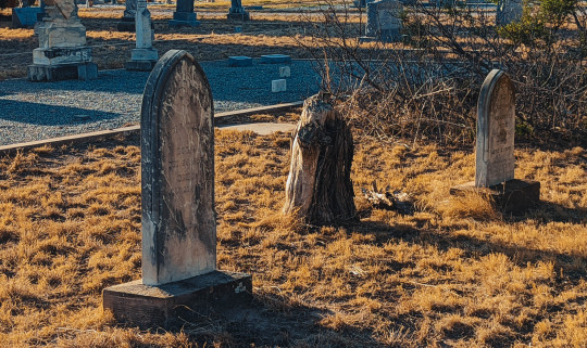

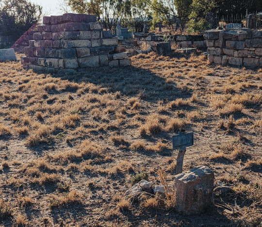

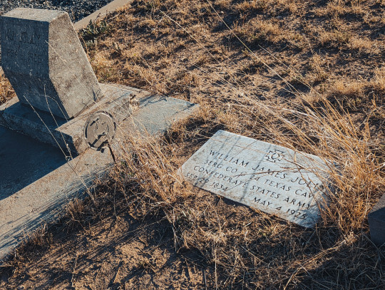

2022.05.26. Montvale Cemetery, located just outside of Sterling City in Sterling County.
Per the Texas Historical Commission: "The community of Montvale was established in 1884 when the pioneer settlement of St. Elmo was relocated here. Then a part of Tom Green County, Montvale was located on the Shafter Military Trail, an early road from Fort Concho. The community began to decline in 1891 with the establishment of Sterling City (3.5 miles northwest) as the seat of government for the newly created Sterling County. A community cemetery is all that remains of Montvale, a pioneer settlement that played an important role in the area's development."
The last image features what I believe is Orthoporus ornatus, the desert millipede. I took these pictures from about 5 to 6 PM. As the sun sank, these fellows started coming out in droves. They ranged from six to eight inches long. I wish I could have taken a better picture to show the sheer number of them! They are completely harmless--in fact, they are beneficial. They consume dead plants and aerate the soil.
Click on Sterling City and Sterling County for more information.
Also, do note that both Sterling City and Sterling County are currently eligible for the Great Texas Landrush. Adopt a Texas town or county and share your message with the world! Funds support the Texas Almanac and the Texas State Historical Association, which are non-profits and depend on your support.
Photos by Rachel Kaelin. Attribution-NonCommercial 4.0 International (CC BY-NC 4.0) Creative Commons license.
#texas#texasalmanac#texas photography#TSHA#texashistory#history#sterlingcitytx#sterlingcountytx#westtexas#photography
0 notes
Photo

White-winged Dove (Zenaida asiatica), Kimble County, Texas.
81 notes
·
View notes
Link
Reminder to my fellow Texans that we’re coming up on the deadline to register to vote in the elections this November! If you don’t know if you’re registered, or think you are but haven’t checked lately, you can double check here!
20 notes
·
View notes
Link
We've been working on our official website for some time. It's a work in progress. One of my goals is a map of Texas showing each species' full range. I'm excited about the beaver's range including Lubbock--a city I'm well-acquainted with. If you've ever been to Lubbock, you'll know it needs as much excitement as it can get!
...no, wait. I should clarify. Lubbock needs more wholesome excitement.
For a list of Texas wildlife: https://www.texasalmanac.com/articles/wildlife
0 notes
Photo
Stockdale is at the junction of U.S. Highway 87 and State highways 97 and 123, thirteen miles northeast of Floresville in eastern Wilson County. The town was named for Fletcher S. Stockdale, lieutenant governor when the town was established in 1863. A post office was established in 1871. German and Polish immigration brought the population to 300 by 1885, when the town had four churches, a school, two mills, two blacksmith shops, two general stores, a grocery, and a drugstore. In 1898 the San Antonio and Gulf Railroad reached Stockdale, and by 1914 the population had grown to 900. By 1925 industries included a planing mill that manufactured furniture and cabinets. In 1929 the estimated population was 1,000. The population declined during the 1930s; in 1939 the town reported 696 residents and thirty-five businesses. Since that time Stockdale has grown steadily, reaching 1,100 in 1965 and 1,264 in 1990. The number of businesses, however, had fallen to twenty-nine by 1990. In 2000 the population was 1,398.
Text adapted from official Handbook of Texas. The Texas Almanac entry for Stockdale is located here.
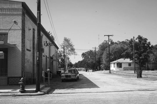
at Stockdale, Texas
https://www.instagram.com/p/CiybLPsrS07/?igshid=NGJjMDIxMWI=
16 notes
·
View notes
Link
Each of these places can be looked up at texasalmanac.com for full details--but we'll give you a head start: https://www.texasalmanac.com/places/bigfoot
#texas#articles#austin county#denton county#ellis county#frio county#henderson county#johnson county#lamar county#montgomery county#roberts county#tarrant county#winkler county#wood county
0 notes
Text
PAISANO PEAK (BREWSTER COUNTY). Paisano Peak is eight miles southwest of Alpine in northwestern Brewster County (at 30°18' N, 103°47' W). Its summit, at an elevation of 6,085 feet above sea level, rises 1,050 feet. Paisano Peak is in the collapsed crater of the Paisano Volcano, which erupted about 35 million years ago. The peak is an intrusion of light-colored rhyolite, a very fine-grained form of granite. The local soils are shallow and stony and support scrub brush and grasses.
Adapted from Texas Handbook

a good bit of rain has turned the desert green
24 notes
·
View notes