#yilgarn
Text

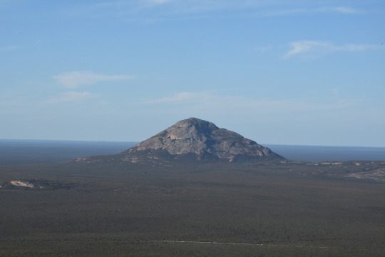
A Granite outcrop rising half a kilometer above the flat surrounding plain. Around 2.6 Billion years old Peak Charles is one of many large outcroppings of ancient bedrock that are exposed across western Australia, this outcrop sits about at the edge of the Yilgarn craton
2 notes
·
View notes
Text
Discovery-Driven Value Creation: Unlocking Investor Opportunities in Platina Resources' Gold Projects
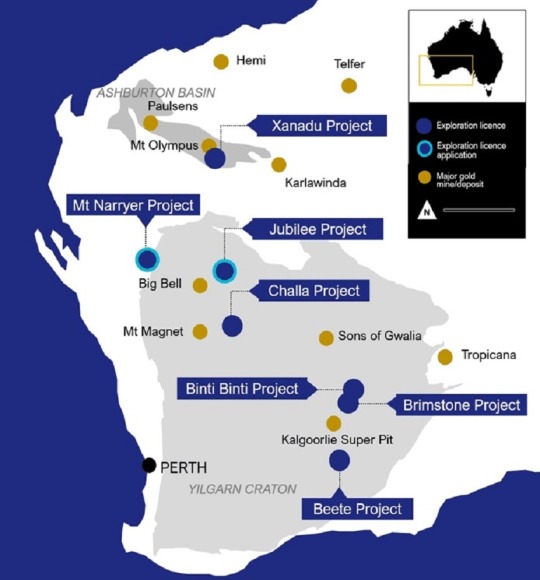
PLATINA RESOURCES (ASX: PGM) is a gold exploration company with promising projects in Western Australia. Its portfolio encompasses seven gold projects in the Ashburton Basin and Yilgarn Craton, spanning a land area of 1,487KM². With a solid history of successful exploration and drilling, the Company possesses ample funding to execute its strategic plans. The Projects are strategically situated in highly favorable regions, offering the potential for significant discoveries. PLATINA RESOURCES boasts advanced exploration and drilling capabilities, supported by an experienced team that excels in exploration and acquisition execution. Given its advantageous position in the current gold market, the Company is well-prepared to achieve substantial breakthroughs. Mr Corey Nolan, the Managing Director of Platina Resources, recently delivered exciting updates on the Company’s gold-focused projects through a recently published INVESTOR’S PRESENTATION.
Platina Scandium Project sold for US$14 million
Platina Resources Limited has entered into a legally BINDING AGREEMENT with a subsidiary of Rio Tinto Ltd to transfer its highly promising Platina Scandium Project for US$14 million. The Platina Scandium Project is a significant global deposit of scandium known for its outstanding quality and the potential to become Australia’s first scandium producer. It also holds valuable cobalt and nickel resources.
According to the agreement, upon the successful completion of the transaction, Platina Resources will receive a cash payment of US$8 MILLION. Additionally, there will be a warranty retention payment of US$1 million, which Rio Tinto will repay after 30 months. As part of the deal, Platina Resources may also receive up to US$6 million in cash payments contingent upon Rio Tinto meeting specific project milestones, such as granting a Mining Lease. This agreement reflects the strong commercial viability of the Platina Scandium Project and highlights Platina Resources’ leading position in scandium exploration.
The finalisation of the transaction depends on obtaining the necessary approval from the NSW Ministerial Consent, which is expected to be concluded soon.
Mr Corey Nolan, Managing Director of Platina Resources, said, “This transaction with Rio Tinto will also allow Platina shareholders to benefit from an injection of new funding to advance its extensive gold portfolio and pursue other more advanced project opportunities without shareholder dilution.“
Gold Focus Transformation of Platina Resources
Platina Resources has transformed its strategic focus from platinum to gold, positioning the Company to capitalize on the solid momentum in the gold market. The scandium sale has boosted the implied value of its Western Australia gold projects, including Xanadu, Brimstone, Beete, Binti Binti, Challa, Mt Narryer JV, and Jubilee.
Before exploring individual gold projects, it’s crucial to acknowledge the favorable gold price environment. As of June 9, 2023, the gold price stood at AUD 3,000 PER OUNCE and USD 2,250 PER OUNCE. The upward trajectory of gold prices enhances the potential returns for investors, making this an opportune time to participate in Platina Resources’ gold exploration endeavors.
Exploration Projects and Drilling Plans of Platina Resources
Platina Resources has three key gold projects scheduled for drilling in 2023: BRIMSTONE, XANADU, AND BEETE. These projects are strategically located in the Ashburton Basin and Yilgarn Craton, renowned for their rich mineral endowment. The vast tenement package spanning 1,487 KM² provides an extensive area for exploration and discovery.
Brimstone Project
The BRIMSTONE PROJECT, located 40km northeast of Kalgoorlie Eastern Goldfields in the Yilgarn Craton, is close to the high-grade Penny’s Find deposit. Historical drilling has revealed extensive gold mineralization, with interpreted geological structures covering approximately 10km of strike length. Brimstone states numerous walk-up drill targets, and the planned reverse circulation drilling in July 2023 will test mineralization at depth and along strike at Brandy, Garibaldi, Old Camp, and Billabong North prospects.
Xanadu Project:
Xanadu Project is situated 29 km south of Parabardoo in the Ashburton Basin. The Project benefits from its proximity to the 1.44MOZ Mt Olympus Gold deposit. The Project shares a similar structural and geological setting to the Mt Olympus deposits located 10 km northwest, indicating significant potential. Rock chip assays have indicated gold values of up to 1.98G/T AU. The upcoming systematic exploration program aims to unlock the Project’s full potential by targeting shallow oxide mineralization and deeper structural targets. Planned activities include the Hermes rock chip and mapping program, cultural heritage approvals, reverse circulation drilling, and diamond drilling at Xanadu West.
Beete Project:
The BEETE PROJECT is 10 km south of the Scotia Mining Centre, which has a significant gold resource of 1 million ounces and is located north of the recently discovered Salmon Gums deposit. The Beete Project, positioned 42km south of Norseman in the Yilgarn Craton, offers substantial gold, lithium, and nickel potential. The Project benefits from its location near the Norseman Greenstone Belt, known for its historical gold production of over 5 million ounces. Aircore and reverse circulation drilling programs are planned in Beete Project for the fourth quarter of 2023, targeting the extension of known gold mines and prospective areas near Scotia Mining Centre and Salmon Gums.
In summary, Brimstone, Xanadu, and Beete are three gold projects that offer substantial potential for gold mineralization, featuring extensive areas for exploration and promising opportunities for discovery.
Financial Overview and Market Dynamics from the Investor’s Presentation
Platina Resources maintains a solid financial position, with a market capitalization of approximately A$16.2 MILLION. As of March 2023, the Company had A$1.3 MILLION IN CASH, and as of June 16, 2023, its investments totaled A$2.36 MILLION. With the recent sale of the scandium project and the injection of new funding from Rio Tinto, Platina is well-positioned to drive value creation through exploration and development activities.
The current market dynamics, characterized by solid gold price momentum, further enhance the investment outlook for Platina Resources. As of June 20, 2023, the gold price stood at A$2,870.45 PER OUNCE, reflecting positive market sentiment and an attractive backdrop for gold exploration and production companies.
As Platina Resources continues its journey towards unlocking the hidden treasures in the Ashburton Basin and Yilgarn Craton, it positions itself as an attractive investment proposition with substantial upside potential.
#gold exploration#Platina Resources#Western Australia#Ashburton Basin#Yilgarn Craton#gold projects#gold market#investor opportunities#strategic plans#exploration and drilling#Corey Nolan#Managing Director#investor presentation#Platina Scandium Project#Rio Tinto#platinum#gold focus#Xanadu#Brimstone#Beete#mineralization#drilling plans#market dynamics#investment outlook
0 notes
Photo

About Managing Director Corey Nolan : Platina Resources
Managing Director of Platina Resources, MR. COREY NOLAN is a senior expert in the mining industry. He has over 25 years of unparalleled experience focusing on various aspects of resource projects including acquisition, financing, exploration and development.
0 notes
Photo
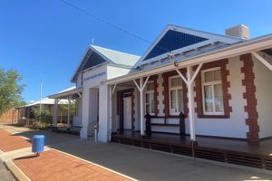
Yilgarn History Museum in Southern Cross, Australia
The Yilgarn History Museum holds an interesting collection of artifacts that offer a fascinating insight into the mining and agricultural history of Southern Cross, a small town in Western Australia. Often referred to as the "Gateway to the Goldfields," Southern Cross was a key part of the early discoveries of gold in the region with the initial gold rush starting here in 1887. This find triggered a mass influx of investment and migration, which saw this area desert soon develop into an important goldfield. This gold was discovered by Thomas Risely and Mick Toomey and interestingly, they claimed that the Southern Cross constellation had assisted their discovery. Visitors to the town can see the main streets are now named after stars that honors and pays tribute to this initial discovery. The museum is found in the historic Registrar's Office and Court House, a building which was constructed in 1891 at the height of the gold rush. It operated as a court until 1976, settling many disputes about the ownership and distribution of gold over the course of many years. The museum is run by the Southern Cross Historical Society and tells the story of the development of the area. Highlights include an old camel wagon, a working model of a gold battery and a number of interesting photographs, documents, and machinery parts.
https://www.atlasobscura.com/places/yilgarn-history-museum
0 notes
Photo
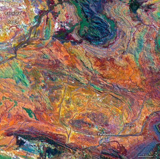
Assembling Australia Formed between 3.6 billion and 2.8 billion years ago, the rocks of the Pilbara Craton in Western Australia are some of the oldest on Earth. The iron-rich rocks here began forming before there was oxygen in Earth’s atmosphere or even life itself. The area also harbors evidence of some of the earliest life—3.45-billion-year-old fossil colonies of microbial cyanobacteria, the oldest known stromatolites on Earth. The false-color image above shows part of the Hamersley Basin in Western Australia, which lies on the southern Pilbara Craton. A craton is the stable, geologically inactive core of an ancient continent. The Pilbara Craton has remained intact, surviving the affronts of plate tectonics and erosion since the Archean Eon (4 billion to 2.5 billion years ago). During the Archean, and the Proterozoic Eon that followed, multiple cratons assembled to form the Australian continent, leaving multiple basins and belts of buckled and folded rocks at their margins. The main cratons that formed Western Australia are the Pilbara and Yilgarn. They began to assemble about 2.2 billion years ago during a mountain-building episode called the Capricorn Orogeny. The land that is today known as the Hamersley Basin was then at the bottom of an ocean lying between the two cratons. The rocks of the basin preserve a record of the last ocean environment in the area before the cratons converged and closed the basin. Atop the granite and greenstone rocks of the Pilbara Craton lie the younger rocks of the Fortescue, Hamersley, and Turee groups, which were deposited between 2.7 billion and 2.3 billion years ago. Together these rocks form the Mount Bruce Supergroup, which holds a singular place in Australia’s geologic history. According to the Geological Survey of Western Australia, not only do these rocks hold the best-preserved sequence of Archean volcanic rocks, but they also include the most continuous rock record of the transition from the Archean to the Proterozoic 2.5 billion years ago (including a record of the Great Oxidation Event). In addition, they are the most economically important ores on the Australian continent. These iron-rich rocks, including the world’s thickest and most extensive banded iron formations, form the basis of the iron-ore mining industry in the region. The image was acquired by the Advanced Spaceborne Thermal Emission and Reflection Radiometer (ASTER) on NASA’s Terra satellite on October 12, 2004. It is a composite of ASTER bands 4-2-1. These bands detect shortwave-infrared light, near-infrared and visible red light, and green light, which are displayed as red, green, and blue, respectively. In this display, iron-rich rocks appear yellow to green. Light-colored, iron-poor rocks appear white, while dark-colored iron-poor rocks are dark blue. Areas with more vegetation cover appear dark red. This is because plants reflect more near-infrared than green light. A linear contrast stretch has also been applied to the image to enhance the color contrast and help distinguish rock types. For example, in the top center of the image, the knob-shaped outcrop colored blue and green shows the rocks of the Hamersley Group—which includes four major banded-iron formations separated by sequences of iron-poor dolomites, shales, and volcanics. At the top left of the image, the white area shows the southeast portion of the Rocklea Dome, which is composed of light-colored granites. The dome is the remnant core of a plunging anticline—a buckled-up ridge that tilts down into the ground. Erosion of the fold’s surface exposed the dome’s granite core, which intruded into the surrounding rock during the Archaean Eon. The dome is also visibly crosscut with basalt intrusions. To the north, these rocks underlie the Hamersley Group, but here they are exposed at the surface. The rest of the image largely shows the area underlain by the volcanic and sedimentary rocks of the Fortescue Group. Much of this land is vegetated, mostly Spinifex grasses, shrubs, and bushes. The bottom of the image shows the town of Paraburdoo and its airport. NASA Earth Observatory image by Joshua Stevens, using data from NASA/METI/AIST/Japan Space Systems, and the U.S./Japan ASTER Science Team. Story by Sara E. Pratt.
8 notes
·
View notes
Text

A moth (Yilgarn) I befriended a while ago came back as a buff moth with 11 wings
I thought they quitted Sky but nope, they now look way more veteran than me lol
3 September 2021
2 notes
·
View notes
Text
2.2 Billion Years: Scientists Date World’s Oldest Meteor Crater
Astronomy logo.
Jan. 21, 2020
A crater in western Australia was formed by a meteor strike more than 2.2 billion years ago and is the world’s oldest known impact site, new research published Wednesday shows.
The study marks the first time that the Yarrabubba crater has been precisely dated, at 2.229 billion years old, and means it is 200 million years older than any similar site known on Earth.
The revelation also raises the intriguing possibility that the massive impact could have significantly altered the Earth’s climate, helping end a period of global “deep freeze.”
Image above: There is geological evidence based on the presence of deposits, of the existence of glaciers on Earth between 2.4 and 2.2 billion years ago. Image Credit: Google Earth.
It is half the age of Earth: the oldest asteroid impact crater, located in western Australia, is 2.2 billion years old. It could be the cause of major climate change, according to a study published Tuesday.
The impact crater of Yarrabubba, about 70 km in diameter, difficult to identify due to the erosion of its original structure, is considered to be one of the oldest on Earth. However, it had so far been impossible to date it accurately.
Snowball Earth (Illustration). Image Credit: NSF
Using an ultra-precise dating method (the sensitive high-resolution ion microprobe), researchers at Curtin University in Perth, Australia, have succeeded in targeting the grains of minerals that have "recorded" the shock of the impact , through a recrystallization process, details their study published in Nature Communications.
Verdict: the crater of Yarrabubba was formed 2.229 billion years ago. This date coincides with the end of a period of glaciation called “Snowball Earth”.
Water vapor
"There is geological evidence (separate from the study, editor's note), based on the presence of deposits, of the existence of glaciers on Earth between 2.4 and 2.2 billion years ago. And the youngest deposit, found in South Africa, corresponds to the age of the impact of Yarrabubba, "said Timmons Erickson, of the Johnson Center of NASA, lead author of the study.
Image above: The Yarrabubba crater lies in western Australia’s Yilgarn craton, one of the most ancient pieces of Earth’s crust. Stars indicate locations where rock samples were taken; the dotted line marks a magnetic signature that researchers used to identify the deeply buried center of the crater. image Credit: University of Wollongong.
If nothing proves the existence of a glacier on the impact zone, "it is interesting to note that at this place, ice deposits are absent from the memory of minerals for about 400 million years after the shock ”, underlines Christopher Kirkland, also author.
The researchers therefore suggested, on the basis of numerical modeling, the scenario of a meteorite which would have struck a frozen landscape, piercing a layer of ice 5 km thick, then projected into the atmosphere a phenomenal amount of water vapor - up to 500 billion tonnes.
Unusual scenario
This ejection of water vapor, "an even more powerful greenhouse gas than CO2", would have led to warming helping the planet to emerge from this ice age.
An unusual scenario, most meteorite impacts being associated with general cooling - the best known example being that of the asteroid which struck the Yucatan in Mexico and would have ended the reign of the dinosaurs around 66 million d years.
Asteroid impact
"Our simulations are unique over a period of glaciation," argues Timmons Erickson, conceding that this is a "hypothesis" at this point. "We hope it will encourage other researchers to investigate the climatic consequences of an impact" during this ice age.
University of Wollongong: https://www.uow.edu.au/
Images (mentioned), Animation, Text, Credits: ATS/AFP/Orbiter.ch Aerospace/Roland Berga.
Best regards, Orbiter.ch
Full article
15 notes
·
View notes
Link
A 70-kilometer-wide crater in Western Australia has officially earned the title of Earth’s oldest known recorded impact. Yarrabubba crater is a spry 2.2 billion years old, plus or minus 5 million years, researchers report January 21 in Nature Communications.
Moving tectonic plates along with erosion have wiped away much of the evidence for many craters older than 2 billion years, leaving a gap in our understanding of how long-ago meteorite impacts may have affected the planet’s life and atmosphere (SN: 12/18/18). Scientists have uncovered ancient impact material older than 2.4 billion years from sites elsewhere in Western Australia and South Africa, but no corresponding craters.
Yarrabubba, located on one of Earth’s oldest patches of crust called Yilgarn craton, adds more than 200 million years to the impact record. The previous record-holder was Vredefort crater in South Africa.
Scientists had estimated Yarrabubba to be between 2.6 billion and 1.2 billion years old, based on previous research dating rocks around the impact site. In the new study, researchers pinpointed the crater’s age by dating microstructures in crystallized rock that formed when the impact occurred.
Dating Earth’s oldest crater was not the only exciting finding, says study coauthor Timmons Erickson, a geologist at NASA’s Astromaterials Research & Exploration Science Division in Houston. The crater’s age puts the impact at the end of an ancient glacial period. A computer simulation suggests that a Yarrabubba-sized impact would have released up to 200 trillion kilograms of water vapor into the atmosphere, which the researchers say could have warmed the planet and melted ice sheets.
8 notes
·
View notes
Text
Dryland Salinity in WA
Dryland Salinity in the Yilgarn Craton of Western Australia
a) The causes of dryland salinity
Dryland salinity in the Yilgarn Craton in Western Australia is a complex issue, with its causes connected to various economic, environmental and social factors. The causes of dryland salinity can be found by examining these different factors and their relation to the water-balance concept and relevant equations. To fully grasp the cause and effects of dryland salinity, it is also vital to consider the Yilgarn Craton during a period in which the water balance was in natural equilibrium.
Hatton et al. (2003) state that pre-European settlement, the water-balance within the Yilgarn Craton was in equilibrium. During this time, the issue of dryland salinity was not present, however high levels of salt within the deeply weathered soil profile did exist and did so as a result of natural processes (McFarlane & Robinson 2002; Hatton et al. 2003). The presence of salt is due to the prevailing onshore winds along the southern coastline, which blow sea spray into the atmosphere which then enters the soil via precipitation at rates of 0010 – 0.017 kg/m2/year in catchments bordering the coast, and 0.002 kg/m2/year for catchments further inland (Hingston and Galaitis, 1976).
The deeply weathered and ancient soils that this rain fell on, are known to have poor water and nutrient holding capacity (Dolling, 2005). As a result, salts from precipitation were leached down through the soil profile, concentrating above the water table in an unsaturated area (Hatton et al. 2003). Prior to settlement, water tables were often at greater than 30 metres deep and tended to be restricted to the saprolite zone (Hatton et al., 2003). As such, the area of concentrated salt was unsaturated and immobilised, and at a depth where the salt had little effect on plant growth (Hatton et al., 2003). Therefore, the issue of dryland salinity is not linked to the amount of salt in the soil profile, but rather the rising of saline solution up toward the surface of the soil profile.
The process of salt mobilisation was initiated by economic and social influences. Postsettlement, European migrants began to clear land in order to turn the native vegetation into profitable agricultural lands. Hatton et al. (2001) state that during a period from 1940 to 1970, the Avon catchment was 65% cleared, with some catchments further upstream on the Avon and Blackwood rivers being 85-95% cleared. This large-scale clearing on a wide range of catchments had crucial environmental responses.
Unknowingly, the removal of this unprofitable vegetation destabilised a water balance equilibrium between hydrological and environmental processes, which had likely existed for millions of years (Hatton et al. 2003). The concept of water balance can be explained through different mathematical relationships, an example from Kim et al. (2003) being:
∆𝑆𝑔 = 𝑃 − 𝑄 − 𝐸𝑇 + 𝑄𝑔 − ∆𝑆𝑠
With: 𝑃 = precipitation, 𝑄 = runoff, 𝐸𝑇 = evapotranspiration, ∆𝑆𝑔 = groundwater storage, 𝑄𝑔 = groundwater inflow, and ∆𝑆𝑠 = soil water storage
Seasonal rainfall patterns associated with the Mediterranean climate of south-western Australia influence all the variables in the above equation (Bureau of Meteorology, 2020). On average, rainfall is highest in winter, and any excess rainfall that infiltrates the soil and is not taken up by plants, drains through the soil profile and recharges the groundwater systems (Hatton et al., 2003). The infiltration of water into the soil profile increases as a result of land clearing and agriculture (Han et al. 2017). Han et al. (2017) showed that grazing activities modify soil structure and reduce vegetation cover density, allowing greater water infiltration. The growing of irrigated crops also contributes to an increase in groundwater inflow. Water used for irrigation is able to flow freely once beneath the root zone of the crop and the use of excessive irrigation can lead to rapid water table rise (Han et al. 2017).
This issue of increased groundwater inflow is exacerbated by the fact that the depth to which native overstorey and midstorey species are able to root, is unmatched by annual crops and pasturage grown for agriculture (Wasson et al. 2014). The native species of flora that dominate the overstorey throughout south-western Western Australia, for example Eucalyptus marginata and Eucalyptus diversicolour, are able to access the water table by sending roots to depths of well over 20 metres (Carbon et al., 1980; Hubble et al., 2010). It is not just Eucalyptus species that have deep roots, there is evidence that Melaleuca, Acacia, and Casaurina species have minimum rooting depths of 3, 2 and 4 metres respectively (Docker, 2003; Hubble et al. 2010). In contrast, the wheatbelts three most profitable plant species, being wheat, barley and canola (Department of Agriculture, 2020), are unable to root as deeply (Wasson et al. 2014). A study of these crops throughout Australia reported an average maximum root depth of 1.5 metres for wheat and barley, and a maximum of 1.06 metres for canola (Wasson et al., 2014; Fan et al., 2016). Over time, water that would have eventually been taken up by native tree roots is instead able to drain freely through the soil profile to the groundwater systems, adding to the increase of groundwater inflow.
In addition to this, a major driver of discharge from groundwater systems is evapotranspiration, or 𝐸𝑇 (Kim et al., 2003). It has been shown that evapotranspiration processes occur at lower rates on most agricultural crops when compared to native species (Farrington et al. 1992; Greenwood et al. 1996). Greenwood et al. (1992) measured evapotranspiration rates of pastures and native Eucalyptus species in the same area, and found that native species such as E. globulus and E. wandoo, had a greater rate of evapotranspiration compared to pasture, as well as a greater annual period in which they facilitated high levels of evapotranspiration. The study did not show data for grain crops, but research has been carried out by Farrington et al. (1992) comparing the evapotranspiration rates of wheat, lupin and barley to heathland and shrubland. The research found that the growing period for crops, which is primarily through winter, provides less opportunity for evapotranspiration than native species which remain active throughout the year, and in many cases even more active in summer (Farrington et al., 1992; Hatton et al., 2003). This further supports the concept that removing native vegetation for pasturage or crops, decreases evapotranspiration thus decreasing the overall rate of groundwater discharge.
The nature of run-off, which contributes to stream flow, has also changed as a result of land clearing. In native bushland, most rainfall infiltrates the soil locally, with the exception of heavy rainfall, and many of the smaller streams would have been dry for most of the year prior to clearing (McFarlane et al., 2003; Hatton et al., 2003). The removal of native trees facilitates increased surface run-off and throughflow (Hatton et al., 2003), this is supported by findings from Ruprecht and Schofield (1991), who state that the Avon river would have flowed at only 18% of its flow rate at the time of the study. This change in stream flow contributes to the destabilising of the water-balance equilibrium.
When examining the origins of dryland salinity, it is clear that land clearing is the primary cause, however, environmental and hydrological responses to clearing play a role in the subsequent rising of the water table, culminating in dryland salinity. A summation of all the above processes can be seen below in Figure 1 (Treidel et al. 2011).
b) Compare and contrast the major management options of salinized land and water resource catchments.
In order to alleviate the effects of dryland salinity, a variety of management options have been considered. The efforts to find solutions to dryland salinity are motivated by concern for the environment, and the financial hardship salinity causes on agricultural industries (Department of Agriculture, 2020). The solutions examined in this response vary in scope, with some designed for single farms or small regions, and others concerning the management of entire catchments. The comparisons drawn between individual solutions will be founded on an economic, practical and environmental basis. It is also important to note that a combination of different approaches and solutions may be required to effectively manage dryland salinity.
One strategy to mitigate dryland salinity that is common to agricultural areas within the Yilgarn Craton, is the use of deep drainage. This is achieved through the excavation of soil resulting in a trench, typically around two-three metres deep, with the excavated soil used as a levee to prevent surface runoff entering the drain (Cox et al., 2005). This solution is based on the premise that the rising water table will encounter the drain before it reaches the soil surface, thus dispersing the saline water safely away from plant crops and maintaining a lowered water table (Cox et al. 2005). However, research concerning deep drainage has shown that the zone of benefit area, that is the region in which groundwater and salinity levels are decreased, may not actually be large enough to justify the high cost of the drain (Kobryn et al. 2015). This fact necessitates the use of multi-drain or parallel drain systems, which are even more costly (Kobryn et al. 2015). Another issue arises when considering what to do with the vast quantities of saline (and sometimes acidic) water that need to be discharged from the drain. If allowed to enter local waterbodies, there can be many negative impacts on biodiversity (Goss, 2003).
A second option to manage dryland salinity regards the integration of deep-rooted perennials within agricultural systems. This can occur through using tree plantations, rather than crops, as a source of profit whilst lowering groundwater levels. One example is the development of Eucalyptus globulus plantations to eventually harvest and sell as timber (Harper et al., 2017). The successful implementation of such a plantation is more complex than the simple drain solution but offers up potential financial reward through sale of the timber and revenue earned from carbon credits, however market demand must also be present (Ward et al. 2011; Harper et al., 2017). The environmental implications of this solution are positive, as it helps not only with lowering the water table, but also in mitigating climate change by sequestering carbon (Ward et al. 2011).
The introduction of deep-rooted perennials into agricultural lands can also occur through alley planting and crop-rotation regimes. Alley plantations have a limitation shared with deep drainage, that is that a trees ability to lower the water table is effective directly beneath themselves, but their zone of benefit decreases quickly adjacent to the alley (Harper et al., 2017). Crop-rotation works by rotating deep-rooted perennial crops with standard agricultural crops. It was noted by Harper et al. (2017) that the long-term environmental benefits of this are small, as after the removal of the perennial crop, water tables are able to rise to their former height thus failing to manage dryland salinity. Both solutions do however allow for agricultural activities to remain somewhat unaffected, but their ability to manage dryland salinity is insufficient to produce significant change.
Another issue arises when management decisions have to contend with the fact that salts are already present in the topsoil, meaning many species, including some deep-rooted perennials, may struggle to grow.
One solution to growing on salinized soils is the use of saltbush and other halophytes as pasturage for livestock. Saltbush species (Atriplex sp.) can grow yearround on salinized soils and have the ability to desalinate soils whilst also providing food for sheep (Barrett-Lennard et al., 1991). Research has been undertaken to improve the biomass, nutritive value and palatability of saltbush varieties, and improved strains of saltbush have been found (Barrett-Lennard et al., 2003). The use of saltbush and other halophytes to manage dryland salinity may be one of the more financially suitable options for farming communities, as it not only helps to desalinize soils and lower the water table, it also reduces livestock feeding costs (Barrett-Lennard et al., 2003).
Another management option is to pursue higher cost solutions in higher value areas, such as installing groundwater intercept bores around important water bodies. For the wheatbelt region this could be Lake Toolibin, a site recognised by the Ramsar Convention (Department of Agriculture, Water and the Environment, 2020). The bores work by removing salinized water in the soil surrounding the chosen area, thus helping to lower the water table and prevent salinization of the waterbody. Successful implementation of this strategy occurred along the Murray River (Treidel et al., 2011). One issue was that water used to irrigate nearby crops then flowed through the soil profile back to the river, taking with it salts stored in the soil. This issue was successfully mitigated through robust government policy, which was based on a credits-debits scheme and incentivized better irrigation practice (Treidel et al., 2011).
With regards to management of entire catchments, many of these solutions may be unviable. For example, the use of deep drainage, alley planting or bore water intercepts have a limited zone of benefit, meaning the positive effects they can create are localised. In order to recover an entire catchment from salinity, extensive revegetation of native species is required. A positive example can be seen in the Denmark catchment, in which the Denmark River has been recovered from salinity, an achievement which is an Australian first (Ward et al. 2011). This was done through government protection of existing native forests, and the encouragement of commercial forestry plantations to replace agriculture, with a focus on communication with stakeholders (Ward et al. 2011). Financially, this system may be unappealing to some landowners, but the costs of dryland salinity are high, and large-scale revegetation practices such as this may be the most effective way to manage groundwater and salinity levels.
From both the Murray River and Denmark catchment examples, it is clear that correct management procedures and clear communication with landowners play a key role in the long-term success of any solution (Ward et al., 2011; Treidel et al., 2011). The existence of markets for any products of reforestation is also essential to ensure that a given solution is financially feasible (Harper et al., 2017). Finally, the ability to communicate the solution in laymen’s terms may be necessary to encourage implementation and adoption (Diagne & Demont, 2007).
1 note
·
View note
Text
#1470 - Hovea pungens - Devil’s Pins
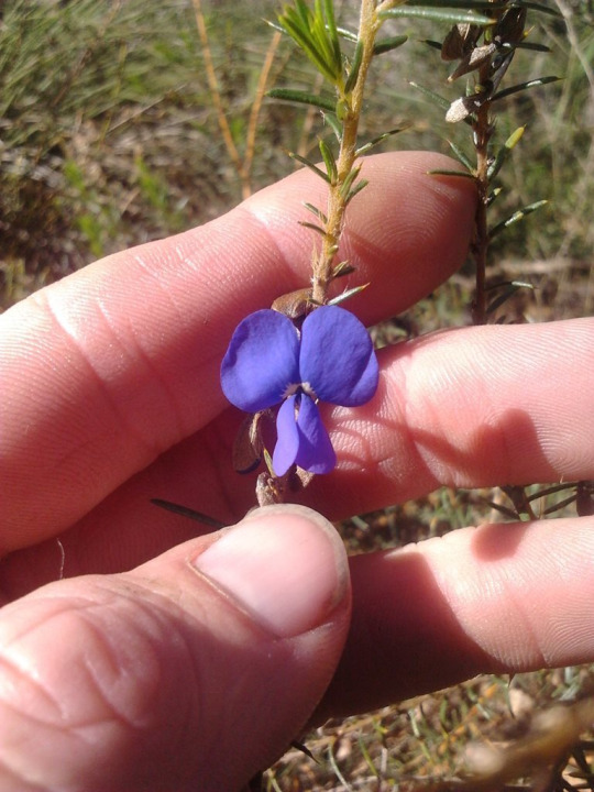
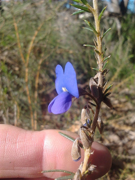
The Noongar name for the plant is buyenak
A very typical example of the heathland flora of SW Western Australia - i.e. waist-high and spiky as fuck. It grows in shallow gravelly, sandy, loamy and clay soils over rock, and among granite outcrops and coastal limestone, and on undulating sandplains and flats. Which probably explains why it’s so common, since that describes most of the SW. Most of the Yilgarn craton is granite half the age of the planet, with the much younger limestone laid down in more recent years during the interglacials.
Hammond Park, Perth
8 notes
·
View notes
Photo
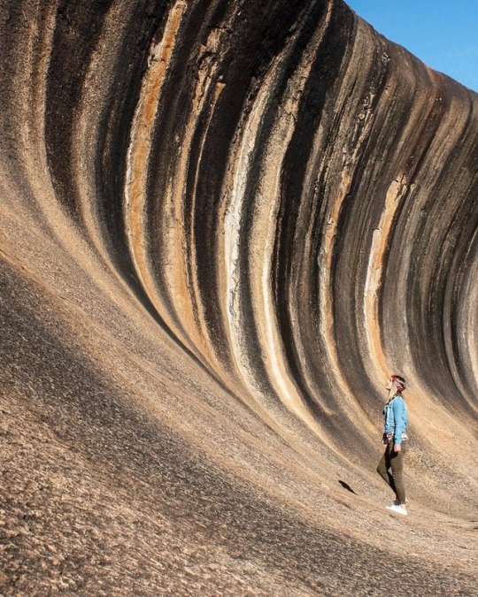
Hyden Rock 🇺🇲, de la cual Wave Rock es parte, consta de 2,63 billones de años de biotita K-feldespato porfiricmonmonzogranito que forma parte de Yilgarn Craton. Hyden Rock es un inselberg de granito, que consta de tres cúpulas. Las cúpulas central y occidental están separadas por un valle profundo, que ahora está ocupado por un embalse. Las cúpulas centrales y orientales están unidas por una plataforma baja. Un proceso de múltiples etapas de desarrollo de formas terrestres creó estas cúpulas. El paso inicial en el desarrollo de Hyden Rock fue la alteración subsuperficial debido a la erosión del lecho rocoso de granito debajo de una superficie de tierra laterificada durante el Período Cretácico entre 100 y 130 millones de años atrás. Dependiendo del grado en que se fracturó por la unión, el lecho de roca de granito que subyace en esta superficie se alteró a profundidades variables debajo de la superficie de la tierra. Este proceso formó "cúpulas" subterráneas de lecho rocoso de granito sólido rodeado de granito profundamente erosionado, relativamente suelto y desagregado. 📸: @stefhoney_s . Hyden Rock, of which Wave Rock is part, consists of 2.63 billion year-old biotite K-feldspar porphyriticmonzogranite that is part of the Yilgarn Craton.[5]Hyden Rock is a granite inselberg, which consists of three domes. The central and western domes are separated by a deep valley, which is now occupied by a reservoir. The central and eastern domes are linked by a low platform. A multistage process of landform development created these domes. The initial step in the development of Hyden Rock was the subsurface alteration by weathering of granite bedrock beneath a lateritised land surface during the Cretaceous Period between 100–130 million years ago. Depending on the degree to which it was fractured by jointing, the granite bedrock underlying this surface was altered to varying depths beneath the land surface. This process formed underground "domes" of solid granite bedrock surrounded by deeply weathered, relatively loose, and disaggregated granite. (en Wave Rock) https://www.instagram.com/p/BtGzEs_A1cA/?utm_source=ig_tumblr_share&igshid=e1mrrk1qi9oi
2 notes
·
View notes
Photo
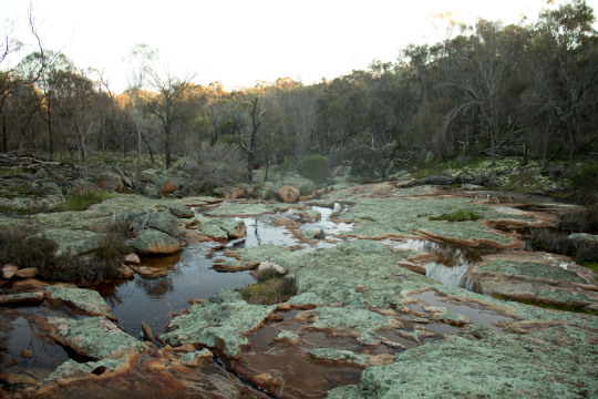
Green-blue lichen covers orange granite berrock on a creekline on the southern edge of the yilgarn craton in Western Australia
16 notes
·
View notes
Text
Unlocking Investor Opportunities in Platina Resources' Gold Projects: A Comprehensive Overview
Platina Resources (ASX: PGM) is an Australian gold exploration company with a strong focus on unlocking the potential of its gold projects in Western Australia. Led by the experienced Managing Director, Mr Corey Nolan, Platina Resources has positioned itself strategically in highly favorable regions, offering significant opportunities for investors. With a recent sale of the Platina Scandium Project, the company has injected new funding into its extensive gold portfolio, making it an attractive investment proposition in the current market.
MEET MR COREY NOLAN, THE MANAGING DIRECTOR OF PLATINA RESOURCES LIMITED:
Mr Corey Nolan, the Managing Director of Platina Resources, brings a wealth of experience and expertise in acquiring, funding, exploring, and developing resource projects. His successful track record, including his previous role as CEO of Sayona Mining Ltd, has positioned him as a leader in the industry. With a strategic vision for Platina Resources, Corey Nolan aims to drive value creation and deliver substantial returns for shareholders.
Gold Focus Transformation of Platina Resources:
Platina Resources has undergone a strategic transformation, shifting its focus from platinum to gold. This shift aligns with the positive momentum in the gold market, providing investors with an opportunity to capitalize on the upward trajectory of gold prices. The recent sale of the Platina Scandium Project has further enhanced the implied value of the company's Western Australia gold projects, including Brimstone, Xanadu, Beete, and others.
Exploration Projects and Drilling Plans of Platina Resources:
Platina Resources possesses a robust portfolio of gold projects strategically located in the Ashburton Basin and Yilgarn Craton. The extensive land area spanning 1,487 KM² provides ample room for exploration and discovery. The company has scheduled three key projects for drilling in 2023: Brimstone, Xanadu, and Beete.
Brimstone Project:
Situated in the Yilgarn Craton, the Brimstone Project is located near the high-grade Penny's Find deposit. Historical drilling has demonstrated extensive gold mineralization, and the upcoming reverse circulation drilling aims to test mineralization at depth and along strike, uncovering the project's full potential.
Xanadu Project:
Located in the Ashburton Basin, the Xanadu Project benefits from its proximity to the Mt Olympus Gold deposit. With similar geological settings to the renowned Mt Olympus deposits, Xanadu holds significant potential for gold mineralization. Planned activities include exploration programs targeting shallow oxide mineralization and deeper structural targets, offering promising opportunities for discovery.
Beete Project:
Positioned in the Yilgarn Craton, the Beete Project boasts substantial gold, lithium, and nickel potential. Its proximity to the Scotia Mining Centre and the recently discovered Salmon Gums deposit further enhances its value. Planned drilling programs in the fourth quarter of 2023 will focus on extending known gold mines and exploring prospective areas, unlocking further opportunities for investors.
Financial Overview and Market Dynamics:
Platina Resources maintains a solid financial position, with a market capitalization of approximately A$16.2 million. The recent sale of the Platina Scandium Project has injected new funding into the company, allowing it to drive value creation through exploration and development activities. The current market dynamics, characterized by solid gold price momentum, create a favorable investment outlook. With gold prices standing at A$2,870.45 per ounce, Platina Resources is well-positioned to maximize returns for its investors.
Conclusion:
As Platina Resources focuses its efforts on unlocking the hidden treasures in the Ashburton Basin and Yilgarn Craton, the company presents an attractive investment opportunity for those looking to capitalize on the strong momentum in the gold market. Led by the experienced Managing Director, Mr Corey Nolan, Platina Resources boasts advanced exploration and drilling capabilities, positioning itself for substantial breakthroughs. With a robust portfolio of gold projects and a solid financial position, Platina Resources is primed to deliver value creation and generate significant returns for its shareholders.
#PLATINA RESOURCES#Corey Nolan#gold exploration#ASX: PGM#Western Australia#Ashburton Basin#Yilgarn Craton#gold projects#investor opportunities#gold market#exploration and drilling#strategic plans#gold price#gold exploration companies#Brimstone Project#Xanadu Project#Beete Project#financial overview#market dynamics#investment outlook#resource projects#mining industry
0 notes
Text
Unlocking the Potential: PLATINA RESOURCES (ASX: PGM) Shines in Western Australia's Gold Exploration
PLATINA RESOURCES (ASX: PGM) is a pioneering gold exploration company that's making waves in the heart of Western Australia. With an impressive collection of projects spread across the Ashburton Basin and Yilgarn Craton, covering a sprawling land area of 1,487KM², PLATINA RESOURCES is at the forefront of the gold exploration scene. Let's delve into the remarkable journey of this dynamic company and its exciting prospects.
PLATINA RESOURCES has carved its niche in the gold exploration realm, with seven promising projects under its belt. The Ashburton Basin and Yilgarn Craton, where these projects are located, are known for their abundant mineral riches. This strategic positioning sets the stage for significant discoveries in the world of gold exploration.
0 notes
Text
Gold targets beckon on Surefire’s new WA tenure
Gold targets beckon on Surefire’s new WA tenure
Surefire has used a historical data review to light up 15 priority gold and nickel targets at its newly granted Perenjori West tenure, 300km northeast of Perth.
The under explored tenure lies within the West Yilgarn nickel-copper-PGE province that has been the recent focus of intense exploration following the discovery of Chalice Mining’s world-class Julimar PGE deposit.
Management says despite…
View On WordPress
0 notes
Photo
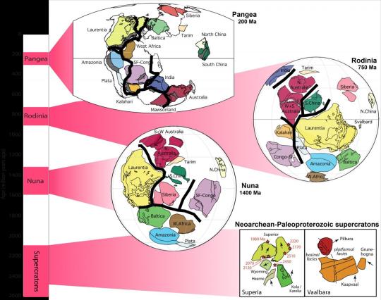
Curtin research finds first clues to start of Earth's supercontinent cycle Curtin University research has uncovered the first solid clues about the very beginning of the supercontinent cycle of Earth, finding it was kick-started two billion years ago. Detailed in a paper published in Geology, a team of researchers from Curtin's Earth Dynamics Research Group found that plate tectonics operated differently before two billion years ago, and the 600 million years supercontinent cycle likely only started during the second half of Earth's life. Lead researcher Dr Yebo Liu from Curtin's School of Earth and Planetary Sciences said that the shift in plate tectonics marked a regime change in the Earth System. "This regime change impacted on the eventual emergence of complex life and even how Earth resources are formed and preserved," Dr Liu said. "Pangea was the first supercontinent scientists discovered early last century that existed some 300 million years ago and lasted until the age of the dinosaurs. Geologists realised more recently that at least two older supercontinents existed before Pangea in the past two billion years (Ga) in a 600 million year cycle. But what happened in the first 2.5 billion years of Earth's history is anybody's guess." "Our research was essentially testing two hypotheses - one is that the supercontinent cycle started prior to two billion years ago. Alternatively, the ancient continents (called cratons) only managed to get together in multiple clusters called supercratons, instead of forming a singular supercontinent." To conduct their tests, the Curtin researchers ventured into the hills east of Perth, Western Australia, an area known as the Yilgarn craton. Dr Liu said Yilgarn was a critical piece of the puzzle not only because it is old, but also because there are a series of dark rocks or dolerite dykes that recorded Earth's ancient magnetic field at the time that the rocks formed. "By precisely dating the rocks and measuring the samples' magnetic record, using a technique called palaeomagnetism, we are able to reconstruct where those rocks were (relative to the magnetic North pole) when they formed," Dr Liu said. Co-author John Curtin Distinguished Professor Zheng-Xiang Li, from Curtin's School of Earth and Planetary Sciences, said by analysing their new data from Yilgarn, and comparing it with data available globally for other cratons, one thing became clear. "It was clear that we can almost rule out the existence of a long-lived single supercontinent before two billion years ago (2 Ga), although transient supercontinents may have existed" Professor Li said. "More likely, there could have been two long-lived clusters of cratons, or supercratons, before 2 Ga that were geographically isolated from each other, never forming a singular supercontinent." Professor Ross Mitchell of the Chinese Academy of Sciences, who was previously a member of Curtin's Earth Dynamics Research Group, said the research goes some way to solving a long-standing mystery. "The idea of an even older supercontinent has been speculated about for years. But while it has been difficult to prove, it has also been difficult to disprove," Professor Mitchell said. Dr Liu said more studies now need to be done. "This study surely isn't the final word on the debate, but it's certainly a step in the right direction and we need to collect data from a lot more similar rocks to further test the hypotheses," Dr Liu said. IMAGE....A graphical summary of Earth's supercontinents/supercratons, modified from D. A. D. Evans, Z. X. Li and J. B. Murphy, Geological Society, London, Special Publications, 424, 1-14, 2 March 2016, https://doi.org/10.1144/SP424.12 Credit modified from D. A. D. Evans, Z. X. Li and J. B. Murphy, Geological Society, London, Special Publications, 424, 1-14, 2 March 2016, https://doi.org/10.1144/SP424.12
3 notes
·
View notes
Last Seen Blogs

tttee44333
Untitled

rapturesdepths
Rapturesdepths

puaskan-isteri-orang
sediakn urutan utk wife...free utk area utara...

supercerdo
SuperCerdo

vegantblog
VEGANT