#thegulfoffinland
Text
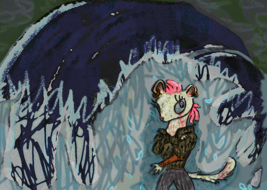
Veruca Dumont
Veruca dumont
#veruca#dumont#verruca#kungfupanda#thedragonknight#weasel#weaselpirate#thegulfoffinland#degrotegolf#thebiggulf#golfslag#zeezicht#神奈川沖浪裏#kanagawa#okinamiura#Hokusai#1830#1831#kungfu#kungfupandafanart#kungfupandaart#Veruca Dumont#netflix#Kung Fu Panda
8 notes
·
View notes
Photo

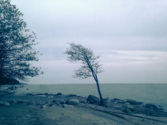
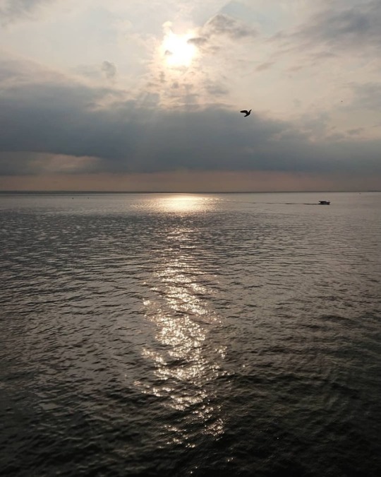
Финский залив The Gulf of Finland #russia #samsung #saintpetersburg #hurricane #komarovo #mobilephotography #thegulfoffinland (at Эко-тропа в Комарово) https://www.instagram.com/p/CIJeLimjwnV/?igshid=1axlzyaxioaqe
51 notes
·
View notes
Photo
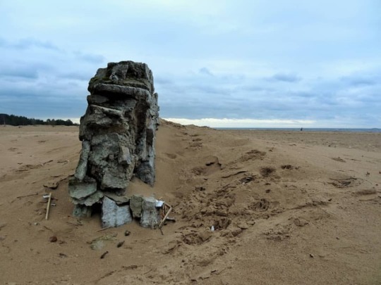
Просто берег Финского залива. Остатки старых советских ограждений на пляже выглядят как древние развалины. . #санктпетербург #финскийзалив #сестрорецк #развалины #saintpetersburg #thegulfoffinland #sestroreck (at Пляж «Ласковый») https://www.instagram.com/andersdeath/p/Bs49MtDng3o/?utm_source=ig_tumblr_share&igshid=1s2kxjtxqspxh
0 notes
Photo
Jurmo Island, Finland. December 2016. OLYMPUS DIGITAL CAMERAhttps://flic.kr/p/LrZca6
0 notes
Photo
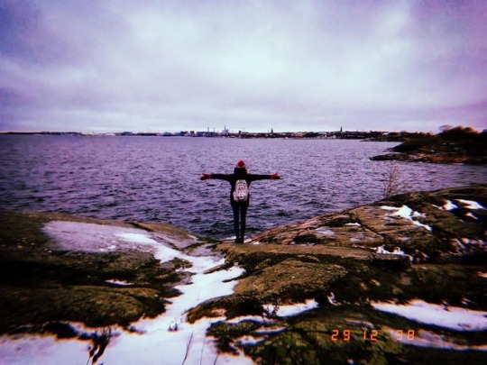
Нет времени объяснять😂 это я на острове в Финке. Бывший остров-крепость, который был и под владением Финляндии, и Швеции и России. Укрепления крепости построены на 7 скалистых островах, которые называются «Волчьи шхеры». Острова примечательны тем, что на них не только расположены музеи и оборонительные форты, церкви, кафе и рестораны, но и здесь есть местные жители! Их около 900 человек, связь с сушей, столицей, осуществляет паром, который за умеренную плату перевозит как туристов, так и автомобилистов каждый день по расписанию. 💁🏽♀️🇫🇮 #travel #travelnotes #island #suomlinna #sveaborg #fortress #travelblogger #gulf #thegulfoffinland #winter #journey #holidays #happynewyear #nature #rock #happiness #scandinavia #city #life #helsingfors #helsinki #finland #vsco #vscocam (at Sveaborg Suomenlinna Viapori Fortress) https://www.instagram.com/p/BsQXR4jFD1p/?utm_source=ig_tumblr_share&igshid=1gsx0st7hal4q
#travel#travelnotes#island#suomlinna#sveaborg#fortress#travelblogger#gulf#thegulfoffinland#winter#journey#holidays#happynewyear#nature#rock#happiness#scandinavia#city#life#helsingfors#helsinki#finland#vsco#vscocam
0 notes
Photo
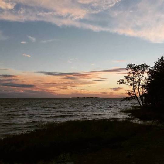
Финский залив с мягким закатом 🕊️⛵☀️ #inmycoloredeyes #подэтимнебом #финскийзалив #фотография #закат #солнце #залив #finnish #thegulfoffinland #travel #naturephotography #photographer #moments #autumn #Herbst #sunset #nice #blue #sunnyday #greatview #wonderful #amazing #landscape #вид #питер #saintpetersburg #clouds #good #perfect #goodnight #фотоохота (at Финский Залив) https://www.instagram.com/p/BnNFX23nQLb/?utm_source=ig_tumblr_share&igshid=1hj183kla2by1
#inmycoloredeyes#подэтимнебом#финскийзалив#фотография#закат#солнце#залив#finnish#thegulfoffinland#travel#naturephotography#photographer#moments#autumn#herbst#sunset#nice#blue#sunnyday#greatview#wonderful#amazing#landscape#вид#питер#saintpetersburg#clouds#good#perfect#goodnight
0 notes
Photo
#sestroretsk #saintpetersburg #russia #thegulfoffinland #финскийзалив #сестрорецк #санктпетербург (at Sestroretsk)
0 notes
Photo
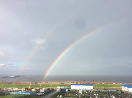
Best view from the window, I admired them at this morning, and wanna do it everytime 🌈#залив #финский #финскийзалив #васильевский #васильевскийостров #остров #утро #счастьерадость #rainbow #morning #goodmorning #vasilevskyisland #seaside #spb #петербург #святой #святойпетерубрг #bay #beach #Suomenlahti #GulfofFinland #theGulfofFinland #такиживу (at Санкт-Петербург, Морская Набережная)
#залив#thegulfoffinland#васильевский#такиживу#святойпетерубрг#spb#bay#rainbow#остров#петербург#финский#beach#goodmorning#vasilevskyisland#gulfoffinland#святой#финскийзалив#утро#васильевскийостров#suomenlahti#seaside#morning#счастьерадость
0 notes
Photo
Some philosophical thoughts before going to bed. And memories from Helsinki. #helsinki #finland #suomi #финляндия #хельсинки #eira #travel #instatravel #sea #baltic #balticsea #thegulfoffinland #scandinavian #scandinavia #scandinavianclub #philosophy #trip #explore #neverstopexploring #sheexplores #ilovehelsinki #wanderer #wander #letsflythere #peacefullness #peaceful #water #horizon
#balticsea#thegulfoffinland#neverstopexploring#sea#trip#wanderer#travel#wander#ilovehelsinki#sheexplores#peaceful#eira#хельсинки#philosophy#water#peacefullness#explore#instatravel#scandinavianclub#scandinavia#helsinki#suomi#finland#финляндия#scandinavian#horizon#letsflythere#baltic
3 notes
·
View notes
Text
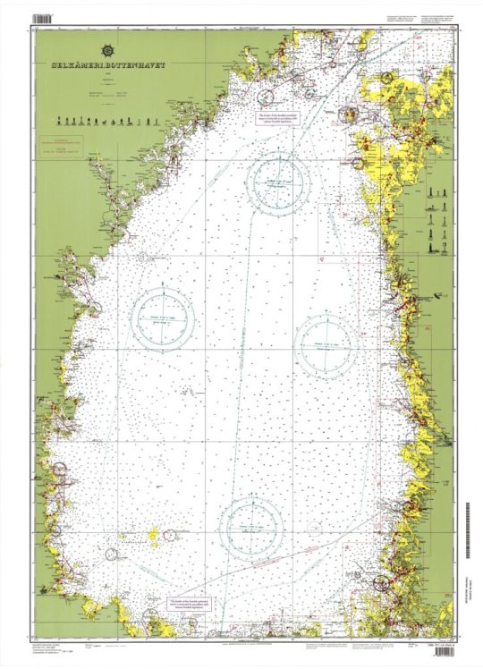
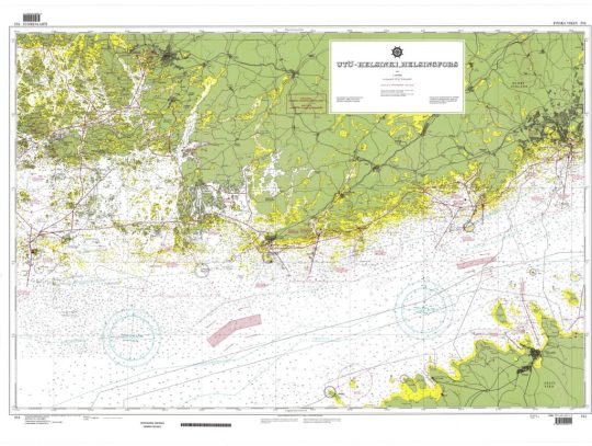
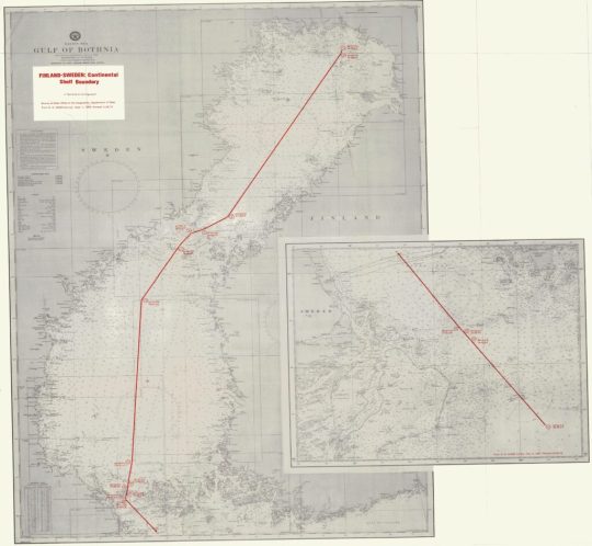
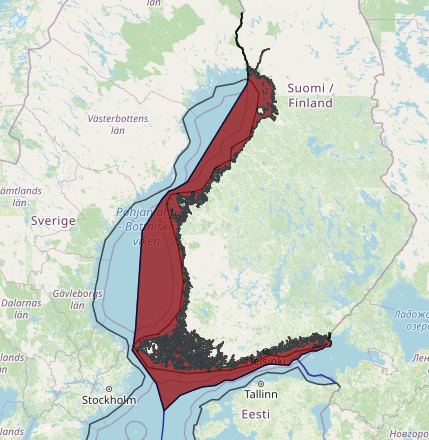
Finland claims about straight baselines and the median line separating the continental shelf and fishery zones of Finland from the continental shelves and exclusive economic zones of Estonia and Sweden
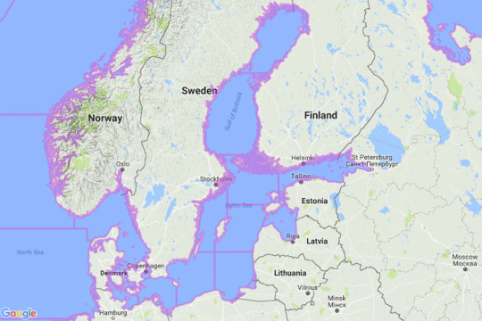
charts showing the straight baselines and the outer limits of the territorial sea of Finland, and the median line separating the continental shelf and fishery zones of Finland from the continental shelves and exclusive economic zones of Estonia and Sweden
mzn16Download

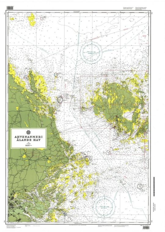
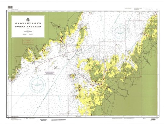
"Loviisa, Lovisa - Kronstadt", Scale 1:200,000 (front)


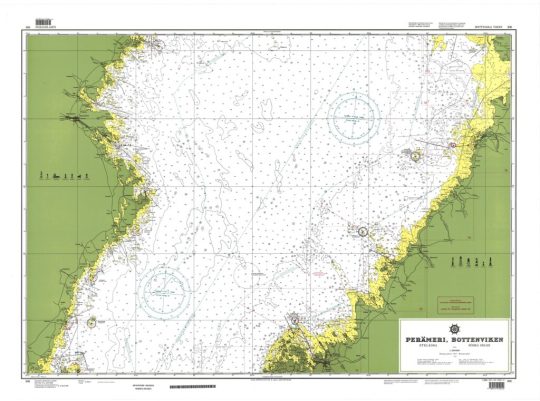
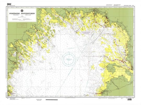
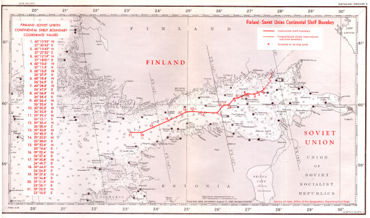
The Finland-Sweden continental shelf agreement is plotted on the attached DMA/HC charts 44030 and 44180. The official Finnish nautical charts cited in Article 6 of the Agreement were used to compute the distances between the boundary points and Finnish straight baselines. Official Swedish charts Nos. 41, 42, 51, 53, and 71 (1:200,000) were used to measure distances to the Swedish baselines.
The shelf boundary extends for a distance of approximately 419.76 nautical miles and has 17 turning or terminal points. The boundary runs the entire length of the Gulf of Bothnia, through the narrow Aland Sea, and into the northernmost part of Baltic Sea.
As stated in Article 2 of the Agreement, the first point on the boundary is the intersection of Sweden's territorial sea limit (4 nautical miles) with the Finland-Sweden territorial sea lateral boundary. From point 1 to point 2 the shelf boundary coincides with the territorial sea boundary. At point 2 the outer limit of Finland's territorial sea (4 nautical miles) intersects the territorial sea and the shelf boundaries. Both states employ a straight baseline system when delimiting their territorial seas.1
The straight line connecting points 2 and 3 is 130.48 nautical miles in length and constitutes the longest single segment of the boundary. Point 9 represents the intersection of the outer limit of Sweden's territorial sea with the straight line between point 8 and the middle of Market. Sweden's 4-nautical-mile territorial sea is, at this point, measured from Market. The short boundary segment from point 9 to point 10 (0.20 nautical miles) coincides with Sweden's territorial sea.
Point 10, according to the Agreement, represents the intersection of Finland's territorial sea limit with the straight line between point 8 and Market. An interesting question arises with regard to Finland's territorial sea limit in the Aland Sea. According to Article II of the Convention on the Non-fortification and Neutralisation of the Aland Islands (signed at Geneva, October 20, 1921), "the territorial sea of the Aland Islands are considered to extend for a distance of three nautical miles from the low-water mark in the islands, islets, and reefs not permanently submerged." In Article 1 of Decree No. 643 of August 18, 1956, establishing Finland's straight baselines system, reference is made to the 1921 Convention regarding the territorial sea limit in the Aland Sea. Yet, on the official Finnish charts Finland's territorial sea in this area is shown to be 4 nautical miles and not 3 nautical miles.
Article 5 of the Finland-Sweden Agreement states only that "points 8, 13, 15, and 17 referred in Articles 3-4 are identical with the points designated in the Aland Convention of 1921 as points 17, 15, 14, and 13, respectively" (emphasis added). Referring to International Legislation No. 54, p. 747, a slight discrepancy occurs between the above four points of the 1921 Aland Convention with the above four points of the Finland- Sweden Agreement. This discrepancy is probably a result of more accurate, modern surveys. The following is a comparison of the 1921 Convention points with the Finland-Sweden
Although Article 1 of the shelf agreement states that the boundary "shall in principle be a median line between the baselines," at no point is the boundary truly equidistant. For a boundary to meet this criterion the entire boundary must be equidistant from two points (one point on each coast or baseline) with the turning points equidistant from three points (two points on one baseline, one point on the other). On this shelf boundary the turning points are not even equidistant from two points.
This fact is recognized by both states. Special circumstances are cited in Article 1; these special circumstances consist of using boundary lines fixed partly in 1811 and partly in the 1921 Convention mentioned earlier. The Agreement also states that, "in order that the boundary line may have a practical and suitable extension it shall be made up of straight lines between points in Arts. 2-4."
The following table shows the distance from the respective baselines to the boundary and the distance between the boundary turning points.

Read the full article
#Estonia#Estoniamaritimeboundaries#Finland#Finlandcontinentalshelfmap#FinlandEEZmap#Finlandmaritimeboundaries#Finlandmaritimeclaims#Finlandstraightbaselines#Finlandterritorialseamap#MaritimeClaims#Sweden#TheGulfofFinland
0 notes
Text
Finland claims about straight baselines and the median line separating the continental shelf and fishery zones of Finland from the continental shelves and exclusive economic zones of Estonia and Sweden

charts showing the straight baselines and the outer limits of the territorial sea of Finland, and the median line separating the continental shelf and fishery zones of Finland from the continental shelves and exclusive economic zones of Estonia and Sweden
mzn16Download

"Loviisa, Lovisa - Kronstadt", Scale 1:200,000 (front)


The Finland-Sweden continental shelf agreement is plotted on the attached DMA/HC charts 44030 and 44180. The official Finnish nautical charts cited in Article 6 of the Agreement were used to compute the distances between the boundary points and Finnish straight baselines. Official Swedish charts Nos. 41, 42, 51, 53, and 71 (1:200,000) were used to measure distances to the Swedish baselines.
The shelf boundary extends for a distance of approximately 419.76 nautical miles and has 17 turning or terminal points. The boundary runs the entire length of the Gulf of Bothnia, through the narrow Aland Sea, and into the northernmost part of Baltic Sea.
As stated in Article 2 of the Agreement, the first point on the boundary is the intersection of Sweden's territorial sea limit (4 nautical miles) with the Finland-Sweden territorial sea lateral boundary. From point 1 to point 2 the shelf boundary coincides with the territorial sea boundary. At point 2 the outer limit of Finland's territorial sea (4 nautical miles) intersects the territorial sea and the shelf boundaries. Both states employ a straight baseline system when delimiting their territorial seas.1
The straight line connecting points 2 and 3 is 130.48 nautical miles in length and constitutes the longest single segment of the boundary. Point 9 represents the intersection of the outer limit of Sweden's territorial sea with the straight line between point 8 and the middle of Market. Sweden's 4-nautical-mile territorial sea is, at this point, measured from Market. The short boundary segment from point 9 to point 10 (0.20 nautical miles) coincides with Sweden's territorial sea.
Point 10, according to the Agreement, represents the intersection of Finland's territorial sea limit with the straight line between point 8 and Market. An interesting question arises with regard to Finland's territorial sea limit in the Aland Sea. According to Article II of the Convention on the Non-fortification and Neutralisation of the Aland Islands (signed at Geneva, October 20, 1921), "the territorial sea of the Aland Islands are considered to extend for a distance of three nautical miles from the low-water mark in the islands, islets, and reefs not permanently submerged." In Article 1 of Decree No. 643 of August 18, 1956, establishing Finland's straight baselines system, reference is made to the 1921 Convention regarding the territorial sea limit in the Aland Sea. Yet, on the official Finnish charts Finland's territorial sea in this area is shown to be 4 nautical miles and not 3 nautical miles.
Article 5 of the Finland-Sweden Agreement states only that "points 8, 13, 15, and 17 referred in Articles 3-4 are identical with the points designated in the Aland Convention of 1921 as points 17, 15, 14, and 13, respectively" (emphasis added). Referring to International Legislation No. 54, p. 747, a slight discrepancy occurs between the above four points of the 1921 Aland Convention with the above four points of the Finland- Sweden Agreement. This discrepancy is probably a result of more accurate, modern surveys. The following is a comparison of the 1921 Convention points with the Finland-Sweden
Although Article 1 of the shelf agreement states that the boundary "shall in principle be a median line between the baselines," at no point is the boundary truly equidistant. For a boundary to meet this criterion the entire boundary must be equidistant from two points (one point on each coast or baseline) with the turning points equidistant from three points (two points on one baseline, one point on the other). On this shelf boundary the turning points are not even equidistant from two points.
This fact is recognized by both states. Special circumstances are cited in Article 1; these special circumstances consist of using boundary lines fixed partly in 1811 and partly in the 1921 Convention mentioned earlier. The Agreement also states that, "in order that the boundary line may have a practical and suitable extension it shall be made up of straight lines between points in Arts. 2-4."
The following table shows the distance from the respective baselines to the boundary and the distance between the boundary turning points.
Read the full article
#Estonia#Estoniamaritimeboundaries#Finland#Finlandcontinentalshelfmap#FinlandEEZmap#Finlandmaritimeboundaries#Finlandmaritimeclaims#Finlandstraightbaselines#Finlandterritorialseamap#MaritimeClaims#Sweden#TheGulfofFinland
0 notes
Text
maritime boundaries between Finland and Russia
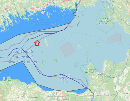
between Russia and Finland, the boundary is on the shore of Gulf of Finland, in which there is a maritime boundary between the respective territorial waters, terminating in a narrow strip of international waters between Finnish and Estonian territorial waters. In 2014, Estonia and the Russian Federation signed their land and maritime boundary agreements that are currently awaiting ratification. This study reconstructs the maritime boundary delimitation between the two States. In particular, the role of islands and pre-existing agreements for the delimitation of the territorial sea boundary in the south-eastern part of the Gulf of Finland are critically examined. It is established that the agreed maritime boundary line is a median line which was influenced by the use of the special circumstances method in the delimitation process. in relation to the first part of the Finland-USSR maritime boundary, military, strategic and related navigational considerations have had a powerful influence on the course of maritime boundaries and it had not based on equidistance method alone.
In the modern period maritime delimitation was, at least initially, conducted among the communist states, together with Finland. However, from the early 1970s, and particularly in the wake of the conclusion of the Treaty on the Basis of Intra-German Relations between the two Germanys, a number of agreements were concluded between Western and Soviet bloc states, despite the profound ideological and economic divides between the littoral states. This remarkable situation has been attributed, not only to small size (the average width being about 120 miles) and semi-enclosed characteristics of the Baltic but to its shallowness (average depth being 55 m), the large number of rivers flowing into it, high coastal populations and a high degree of industrialization among the littoral states. This combination of factors dictated a clear need for cooperation’. considered chronologically, maritime boundaries in the Baltic Sea have therefore been concluded between Denmark and Germany (1965 and 1988), Finland and the USSR (1965, 1967, 1980 and 1985) and more..
Finland was the first, in 1956, when it placed the termini of its model straight baselines in the sea to link with subsequent baselines drawn by Sweden and Russia. Finland For most of length straight baselines cross water but their termini are on land and are defined by the coordinates on or near the normal baseline. It would be prudent for countries to review the coordinates defining their straight baselines at set intervals. This would ensure that any changes in the configuration of the low-water line can be recorded and the coordinates of basepoints adjusted. Finland seems to be the only country that specified in its declaration of its straight baselines that they would be reviewed every 30 years.
in 1995 Finland reviewed the 1965 definition of its baselines. Finland took the opportunity to abandon its requirement that no segment of its baselines should be longer than 8 nm. The length of baselines in the previous system averaged 4.4 nm. The previous system ensured that the Finnish straight baselines conformed to the coast to a greater degree than those of any other country. The new arrangements allow the Finns to use fewer basepoints which will reduce the costs of future measurements. The 1995 definition will cover the period 1995-2024.
Agreement between the Government of the Republic of Finland and the Government of the Union of Soviet Socialist Republics concerning the boundaries of sea areas and of the continental shelf in the Gulf of Finland, 20 May 1965Download
Agreement between the Government of the Republic of Finland and the Government of the Union of Soviet Socialist Republics concerning the boundary of the continental shelf between Finland and the Soviet Union in the north-eastern part of the Baltic Sea, 5 May 1967 (entry into force: 15 March 1968)Download
Agreement between the Government of the Republic of Finland and the Government of the Union of Soviet Socialist Republics regarding the delimitation of the areas of Finnish and Soviet jurisdiction in the field of fishing in the Gulf of Finland and the North-eastern Part of the Baltic Sea, 25 February 1980 (entry into force: 9 July 1980)Download
Agreement between the Government of the Republic of Finland and the Government of the Union of Soviet Socialist Republics regarding the delimitation of the economic zone, the fishing zone and the continental shelf in the gulf of Finland and in the North-Eastern part of the Baltic Sea, 5 February 1985 (entry into force: 24 November 1986)Download

Russia Straight baseline-internal waters-territorial waters in gulf of Finland
Russian Exclusive economic Zone in gulf of Finland
Finnish Exclusive Economic Zone
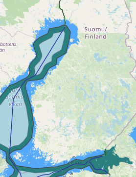
Finland Stright baseline-internal waters-territorial waters
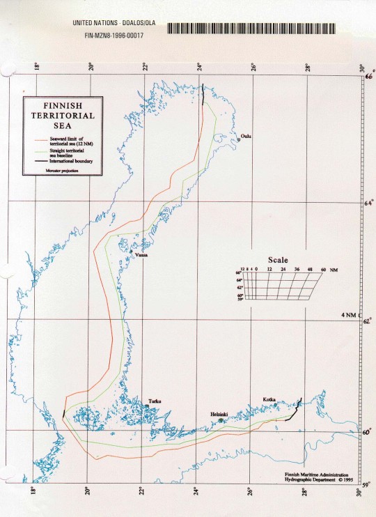
map (provisional) and of a list of geographical coordinates (straight baselines; outer limits of the territorial sea) of Finland
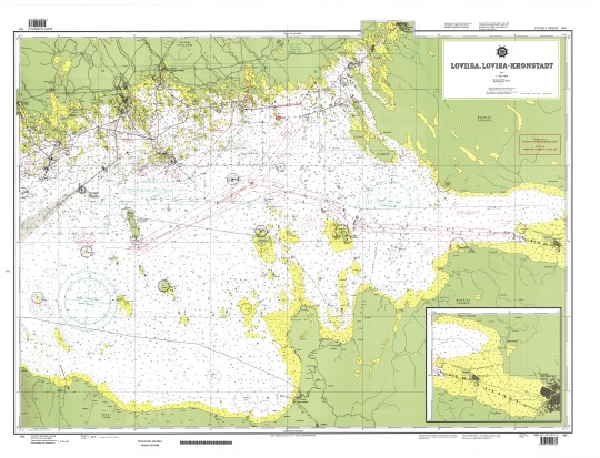
"Loviisa, Lovisa - Kronstadt", Scale 1:200,000

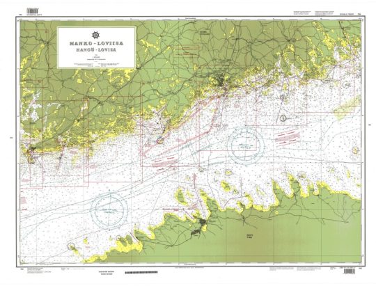
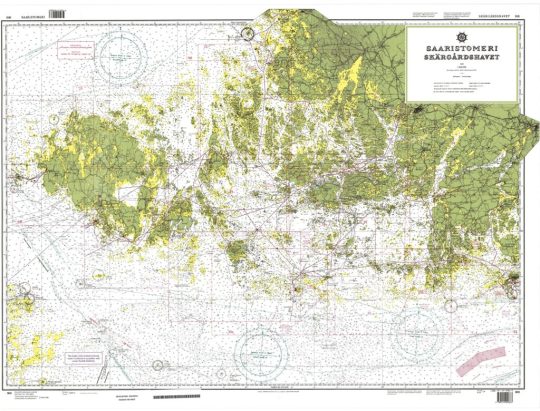
"Hanko-Loviisa/Hangö-Lovisa", Scale 1:200,000
Read the full article
#Finland#Finlandcontinentalshelfmap#FinlandEEZmap#Finlandfisheryzonesmap#Finlandinternalwatersmap#Finlandmaritimeboundaries#Finlandmaritimeclaims#Finlandstraightbaselines#Finlandterritorialseamap#russia#Russiacontinentalshelfmap#Russiaexclusiveeconomiczonemap#Russiainternalwatersmap#Russiamaritimeboundaries#Russiamaritimeclaims#Russiaterritorialwatersmap#russianfederation#TheGulfofFinland
0 notes
Photo
#сестрорецк #sestroretsk #saintpetersburg #санктпетербург #финскийзалив #thegulfoffinland (at Sestroretsk)
0 notes
Photo
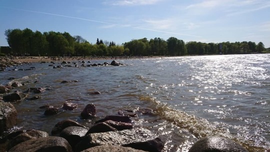
Бесконечные волны, блики, плеск 🌅 Быть многогранным не значит быть плохим. Вода мягко и безжалостно точит камни, солнце греет и слепит одновременно. 🌦️ Невозможно быть только хорошим, нельзя всё время терпеть и запрещать себе быть когда-то твёрдым к людям и обстоятельствам. Лучше быть собой и остаться с теми, кто примет тебя настоящим, чем, подобно вулкану, копить в себе ярость, соотвествуя требованиям общества и усыпляя чувства и эмоции 🌋 #финскийзалив #thegulfoffinland #travel #composition #view #water #waves #moments #lifestyle #счастье #спокойствие #природа #солнце #камни #legs #Аняня #няАня #мысливслух #живи #жирноморда #nature #пустьмирподождет #моменты #природа #душа #фотоохота (at Gulf of Finland)
#жирноморда#thegulfoffinland#waves#живи#пустьмирподождет#солнце#moments#финскийзалив#lifestyle#travel#моменты#nature#счастье#view#душа#природа#legs#аняня#composition#няаня#water#мысливслух#фотоохота#камни#спокойствие
0 notes
Last Seen Blogs

p-aulline-blog
Sans titre

yomimonobox
朗読保管庫
caluanie
CALUANIE OFFICIAL

chiishiko
Cishico
savcilarintarafsizolmamasi
DOSYAMIZDA GÖREVLENDİRİLEN SAVCILARIN TARAFSIZ DAVRANMADIĞIN