#southern ocean
Text
youtube
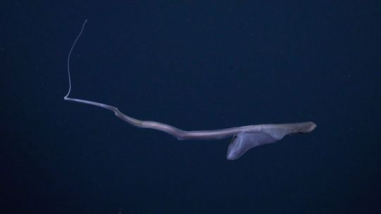
The Can-do Pelican Eel
The pelican eel, also known as the gulper eel (Eurypharynx pelecanoides), are the only known species of eel in the family Eurypharyngidae. They are found exclusively in the deeper parts of the water column, from depths of 500 up to to 3,000 m (1,600 to 9,800 ft), but are distributed throughout all the world's oceans.
The gulper eel is perhaps most famous for its unique body shape. Like many deep-sea fish, this species is highly adapted to its environment; maximum energy efficiency is the highest priority. To that end, the pelican eel has a large head, and a jaw estimated to be quarter of the total length of its body. The jaw is loosely hinged, meaning that gulper eels can open their mouths extremely wide. The rest of the eel, in contrast, is quite slender and long, about 0.75 m (2.5 ft) in length on average. Most individuals are black--so black, in fact, that they only reflect 0.5% of light; perfect for hiding from potential predators.
Although they look skinny, E. pelecanoides can expand their stomachs to hold prey much larger than themselves. Their primary prey consists of crustaceans and cephalopods, though they may feed opportunistically on other fish. Because it is so well camouflaged, it uses bioluminescent organs on the tip of its tail to attract prey. Gulper eels themselves are preyed upon by lancetfish and other larger deep-sea fish. To deter predators, they will gulp down a large amount of water; this stretches the loose skin around their head and throat, and inflates them to several times their usual size.
Because of their remote location, the breeding habits of gulper eels are relatively unknown. However, it is believed that smell plays a large part in attracting a mate, as pelican eels have highly developed olfactory organs. Like other eels, they're born as tiny, transparent larvae in a state known as the leptocephalus stage. At this stage, they do not have any red blood cells. Researchers aren't sure how long it takes gulper eels to become fully mature, or how long they live, but many believe that adults die shortly after mating.
Conservation status: The population size of E. pelecanoides has not been assessed, and thus the IUCN has not made a determination on its status. The greatest threat for this species is deep-sea trawling, which frequently brings up gulper eels as by-catch.
Photos/Video
Paul Caiger
Schmidt Ocean Institute
EV Nautilus Team (I highly recommend checking out their 2023 highlights reel!)
#pelican eel#gulper eel#Anguilliformes#Eurypharyngidae#eels#ray-finned fish#bony fish#fish#pelagic fauna#open ocean fauna#pelagic fish#deep sea#deep sea fish#Atlantic Ocean#Pacific Ocean#Indian Ocean#Arctic Ocean#Southern Ocean#animal facts#biology#zoology#ecology#marine fauna#marine fish#Youtube
128 notes
·
View notes
Text
2024 March 31
A totally eclipsed Sun is seen in the distance. Around the eclipse is a dark region dipping down from above. Below that are clouds and below that is the wing and engine of an airplane.
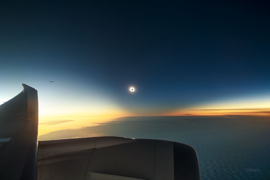
Total Solar Eclipse Below the Bottom of the World
Image Credit & Copyright: Petr Horálek (ESO Photo Ambassador, Inst. of Physics in Opava) ; Acknowledgement: Xavier Jubier
Explanation: In late 2021 there was a total solar eclipse visible only at the end of the Earth. To capture the unusual phenomenon, airplanes took flight below the clouded seascape of Southern Ocean. The featured image shows one relatively spectacular capture where the bright spot is the outer corona of the Sun and the eclipsing Moon is seen as the dark spot in the center. A wing and engine of the airplane are visible across the left and bottom of the image, while another airplane observing the eclipse is visible on the far left. The dark area of the sky surrounding the eclipsed Sun is called a shadow cone. It is dark because you are looking down a long corridor of air shadowed by the Moon. A careful inspection of the eclipsed Sun will reveal the planet Mercury just to the right. You won't have to travel to the end of the Earth to see the next total solar eclipse. The total eclipse path will cross North America on 2024 April 8, just over one week from today.
#astronaut#astronomers#not astrology#star#stars#art#astronomy#outer space#space#artist#earth#eclipse#2021#total solar eclipse#solar system#solar#solar eclipse#southern ocean#sun#moon#sun and moon#airplanes#airplane#shadow cone#shadow of moon#shadow of eclipse#mercury#planets#planet#april 8 2024
30 notes
·
View notes
Text

On the edge of the Bight
On my travels
#original photographers#nature photography#landscape photography#Great Australian Bight#clouds#Southern Ocean
107 notes
·
View notes
Text

This photo was taken during a special flight dedicated to chasing the Aurora Australis above the Southern Ocean. When the Milky Way entered the same frame as the Aurora Australis, it was the best light show of the year for me. South Australia.
Photograph: Jiayuan Liang
The Australian Geographic Nature Photographer Of The Year 2023
#jiayuan liang#photographer#the australian geographic nature photographer of the year#australia#aurora australis#southern lights#southern ocean#milky way#night sky#south australia#landscape#nature
26 notes
·
View notes
Text
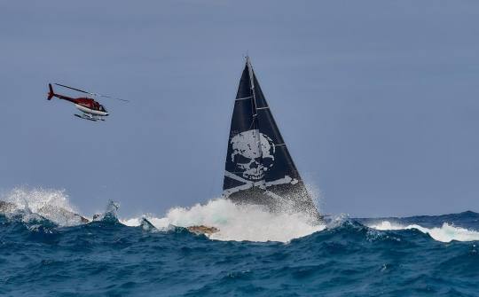
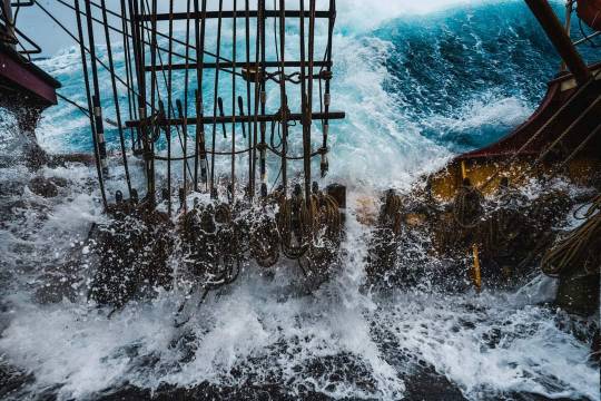
Southern Ocean's 32m Danneskjold
29 notes
·
View notes
Text

Interesting cloud formation over the Weddell Sea. @travelgraphics
#original photography#cannon camera#photographer on tumblr#nature#landscape#pws photos worth seeing#water#clouds#cloud formation#Weddell Sea#Southern Ocean#Antarctica#icebergs
59 notes
·
View notes
Text

Gerlache killer whale Orcinus orca
Observed by stevestevens, public domain
#Orcinus orca#Gerlache killer whale#Cetacea#Delphinidae#cetacean#whale#dolphin#Antarctica#Southern Ocean#Gerlache Strait
21 notes
·
View notes
Text

Ocean Beach at sunset, Denmark, Western Australia (Southern Ocean - nothing between here and Antarctica)
(C) @branchflowerphoto 2023
#original photographers#photographers on tumblr#western australia#nature photography#landscape#australia#photography#landscape photography#lensblr#nature#denmark wa#sunset#southern Ocean
25 notes
·
View notes
Text
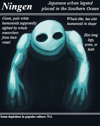
Referred to in Japanese by the same word that means "human", the Ningen is a supposed human-shaped creature likened to a whale in the subantarctic region of the Southern Ocean.
#BriefBestiary#bestiary#digital art#fantasy#folklore#legend#urban legend#cryptid#cryptozoology#japanese legend#japanese urban legend#southern ocean#whale monster#monster#sea monster#ningen#antarctic legend#antarctic monster
111 notes
·
View notes
Text
And please tell me your reasoning in the tags
42 notes
·
View notes
Text
Southern Ocean
In 2000, the Southern Ocean is the newest ocean recognized by the International Hydrographic Organization.
It borders Antarctica in its entirety.
In terms of size, it’s the fourth-largest at 20,327,000 square kilometers. It extends out to 60 degrees South latitude.
It’s an extreme environment and is the least understood of the 5 oceans. This is because it is unexplored, far from populated areas, and has a severe climate. Despite the Southern Ocean being unexplored, about 80% of all oceans in the world are unexplored. There’s still a lot of work to do for ocean exploration.
Includes: Amundsen Sea, Bellingshausen Sea, part of the Drake Passage, Ross Sea, a small part of the Scotia Sea, Weddell Sea, and other tributary water bodies
Area
Total Area: 21.96 million sq km
Area - Comparative: Slightly more than twice the size of the US
Coastline: 17,968 km
Climate: Sea temperatures vary from about 10 degrees Celsius to -2 degrees Celsius; cyclonic storms travel eastward around the continent and frequently are intense because of the temperature contrast between ice and open ocean; the ocean area from about latitude 40 south to the Antarctic Circle has the strongest average winds found anywhere on Earth; in winter the ocean freezes outward to 65 degrees south latitude in the Pacific sector and 55 degrees south latitude in the Atlantic sector, lowering surface temperatures well below 0 degrees Celsius; at some coastal points intense persistent drainage winds from the interior keep the shoreline ice-free throughout the winter
Ocean Volume: 71.8 million cu km
Percent of World Ocean Total Volume: 5.4%
--------------------------------------------------------------------------
Bathymetry
Continental Shelf: A rather flat area of the sea floor adjacent to the coast that gradually slopes down from the shore to water depths of about 200 m (660 ft). Dimensions can vary: they may be narrow or nearly nonexistent in some places or extend for hundreds of miles in others. The waters along the continental shelf are usually productive in both plant and animal life, both from sunlight and nutrients from ocean upwelling and terrestrial runoff. Compared to the continental shelf found in other oceans, in Antarctica the continental shelf is narrower and much deeper. In addition, the continental shelf has been deeply scoured by glacial action.
Astrid Ridge
Belgrano Bank
Gunnerus Ridge
Hayes Bank
Iselin Bank
Continental Slope: Where the ocean bottom drops off more rapidly until it meets the deep-sea floor (abyssal plain) at about 3,200 m (10,500 ft) water depth. The deep waters of the continental slope are characterized by cold temperatures, low light conditions, and very high pressures. Sunlight does not penetrate to these depths, having been absorbed or reflected in the water above. The continental slope can be indented by submarine canyons, often associated with the outflow of major rivers. In the case of Antarctica, the continental slope has been scoured by glacial action cutting troughs and canyons down the slope. Another feature of the continental slope are alluvial fans or cones of sediments carried downstream to the ocean by major rivers and deposited down the slope.
Southern Ocean
Amery Basin
Filchner Trough
Hillary Canyon
Pobeda Canyon
Abyssal Plains: At depths of over 3,000 m (10,000 ft) and covering 70% of the ocean floor, are the largest habitat on earth. Sunlight does not penetrate to the sea floor, making these deep, dark ecosystems less productive than those along the continental shelf. Despite their name, these “plains” are not uniformly flat; they are interrupted by features like hills, valleys, and seamounts.
Amundsen (Abyssal) Plain
Enderby (Abyssal) Plain
South Indian/Australian-Antarctic Basin
Southeast Pacific/Bellinghausen Basin
Weddell (Abyssal) Plain
Mid-Ocean Ridge: Rising up from the abyssal plain, is an underwater mountain range, over 64,000 km (40,000 mi) long, rising to an average depth of 2,400 m (8,000 ft). Mid-ocean ridges form at divergent plate boundaries where two tectonic plates are moving apart and new crust is created by magma pushing up from the mantle. Tracing their way around the global ocean, this system of underwater volcanoes forms the longest mountain range on Earth. Fracture Zones are linear transform faults that develop perpendicular to the line of the mid-ocean ridge which can offset the ridge line and divide it into segments.
Pacific-Antarctic Ridge
Undersea Terrain Features: The Abyssal Plain is commonly interrupted by a variety of commonly named undersea terrain features including seamounts, guyots, ridges, and plateaus. Seamounts are submarine mountains at least 1,000 m (3,300 ft) high formed from individual volcanoes on the ocean floor. They are distinct from the plate-boundary volcanic system of the mid-ocean ridges, because seamounts tend to be circular or conical. A circular collapse caldera is often centered at the summit, evidence of a magma chamber within the volcano. Flat topped seamounts are known as guyots. Long chains of seamounts are often fed by "hot spots" in the deep mantle. These hot spots are associated with stationary plumes of molten rock rising from deep within the Earth's mantle. These hot spot plumes melt through the overlying tectonic plate as it moves and supplies magma to the active volcanic island at the end of the chain of volcanic islands and seamounts. An undersea ridge is an elongated elevation of varying complexity and size, generally having steep sides. An undersea plateau is a large, relatively flat elevation that is higher than the surrounding relief with one or more relatively steep sides. Although submerged, these features can reach close to sea level.
Akopov Seamounts
De Gerlache Seamounts
Endurance Ridge
Marie Byrd Seamount
Maud Rise
Scott Seamounts
Ocean Trenches: The deepest parts of the ocean floor and are created by the process of subduction. Trenches form along convergent boundaries where tectonic plates are moving toward each other, and one plate sinks (is subducted) under another. The location where the sinking of a plate occurs is called a subduction zone. Subduction can occur when oceanic crust collides with and sinks under (subducts) continental crust resulting in volcanic, seismic, and mountain-building processes. Subduction can also occur in the convergence of two oceanic plates where one will sink under the other and in the process create a deep ocean trench. Subduction processes in oceanic-oceanic plate convergence also result in the formation of volcanoes. Over millions of years, the erupted lava and volcanic debris pile up on the ocean floor until a submarine volcano rises above sea level to form a volcanic island. Such volcanoes are typically strung out in chains called island arcs. As the name implies, volcanic island arcs, which closely parallel the trenches, are generally curved.
South Sandwich Trench; the deepest location in the Southern Ocean
Atolls: Due to the extremely cold water there are no atolls in the Southern Ocean
--------------------------------------------------------------------------
Highest Point: Sea Level
Lowest Point: Southern end of the South Sandwich Trench -7,434 m unnamed deep
Mean Depth: -3,270 m
Ocean Zones: Composed of water and in a fluid state, the ocean is delimited differently than the solid continents. The ocean is divided into three zones based on depth and light level. Although some sea creatures depend on light to live, others can do without it. Sunlight entering the water may travel about 1,000 m into the oceans under the right conditions, but there is rarely any significant light beyond 200 m.
The upper 200 m (656 ft) of the ocean is called the euphotic, or "sunlight," zone. This zone contains the vast majority of commercial fisheries and is home to many protected marine mammals and sea turtles. Only a small amount of light penetrates beyond this depth.
The zone between 200 m (656 ft) and 1,000 m (3,280 ft) is usually referred to as the "twilight" zone, but is officially the dysphotic zone. In this zone, the intensity of light rapidly dissipates as depth increases. Such a minuscule amount of light penetrates beyond a depth of 200 m that photosynthesis is no longer possible.
The aphotic, or "midnight," zone exists in depths below 1,000 m (3,280 ft). Sunlight does not penetrate to these depths and the zone is bathed in darkness.
--------------------------------------------------------------------------
Natural Resources: Probable large oil and gas fields on the continental margin; manganese nodules, possible placer deposits, sand and gravel, fresh water as icebergs; squid, whales, and seals - none exploited; krill, fish
Natural Hazards: Huge icebergs with drafts up to several hundred meters; smaller bergs and iceberg fragments; sea ice (generally 0.5 to 1 m thick) with sometimes dynamic short-term variations and with large annual and interannual variations; deep continental shelf floored by glacial deposits varying widely over short distances; high winds and large waves much of the year; ship icing, especially May-October; most of region is remote from sources of search and rescue
Geography - Note: The major chokepoint is the Drake Passage between South America and Antarctica; the Polar Front (Antarctic Convergence) is the best natural definition of the northern extent of the Southern Ocean; it is a distinct region at the middle of the Antarctic Circumpolar Current that separates the cold polar surface waters to the south from the warmer waters to the north; the Front and the Current extend entirely around Antarctica, reaching south of 60 degrees south near New Zealand and near 48 degrees south in the far South Atlantic coinciding with the path of the maximum westerly winds
--------------------------------------------------------------------------
Enviornment
Enviornment - Current Issues: Changes to the ocean's physical, chemical, and biological systems have taken place because of climate change, ocean acidification, and commercial exploitation
Enviornment - International Agreements: The Southern Ocean is subject to all international agreements regarding the world's oceans; in addition, it is subject to these agreements specific to the Antarctic region: International Whaling Commission (prohibits commercial whaling south of 40 degrees south [south of 60 degrees south between 50 degrees and 130 degrees west]); Convention on the Conservation of Antarctic Seals (limits sealing); Convention on the Conservation of Antarctic Marine Living Resources (regulates fishing) note: mineral exploitation except for scientific research is banned by the Environmental Protocol to the Antarctic Treaty; additionally, many nations (including the US) prohibit mineral resource exploration and exploitation south of the fluctuating Polar Front (Antarctic Convergence), which is in the middle of the Antarctic Circumpolar Current and serves as the dividing line between the cold polar surface waters to the south and the warmer waters to the north
Climate: Sea temperatures vary from about 10 degrees Celsius to -2 degrees Celsius; cyclonic storms travel eastward around the continent and frequently are intense because of the temperature contrast between ice and open ocean; the ocean area from about latitude 40 south to the Antarctic Circle has the strongest average winds found anywhere on Earth; in winter the ocean freezes outward to 65 degrees south latitude in the Pacific sector and 55 degrees south latitude in the Atlantic sector, lowering surface temperatures well below 0 degrees Celsius; at some coastal points intense persistent drainage winds from the interior keep the shoreline ice-free throughout the winter
--------------------------------------------------------------------------
Ports and Terminals
Major Seaport(s): McMurdo, Palmer, and offshore anchorages in Antarctica
Note: Few ports or harbors exist on the southern side of the Southern Ocean; ice conditions limit use of most to short periods in midsummer; even then some cannot be entered without icebreaker escort; most Antarctic ports are operated by government research stations and, except in an emergency, are not open to commercial or private vessels
5 notes
·
View notes
Photo

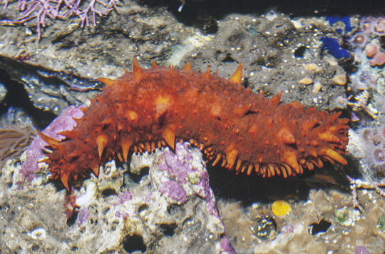


A Striking Salad of Sea Cumbers
No, they’re not a vegetable-- sea cucmbers make up the class Holothuroidea, which is a member of the echinoderm family-- invertebrates which also include star fish, sea urchins, and sand dollars. There are about 1,700 species of sea cucumber found on the ocean floor, in open water, and in coral reefs. These invertebrates are found all over the world, but the greatest variety of species can be found in the Asian Pacific, in reefs around Southeast Asia, Indonesia, and eastern Australia.
While they are invertebrates, sea cucumbers do have an internal skeleton: a structure made of tiny calcified branches called ossicles that are joined throughout the skin by connective tissue. Some species enlarge their ossicles to form hard plates, which can protect them from predators. Outside this common feature, sea cucumbers can take many forms. The stereotypical sea cucumber has a cylindrical body, often with bumps that resemble warts. These bumps have important functions ranging from locomotion to feeding, and in some species the bumps are elongated into tentacles. Most species also posses five pairs of tube-like feet. Outside the stereotype, however, members of the Holothuroidea class can take many forms, ranging from perfectly round to worm-like, and with many variations on appendages, location, and predatory defense. The average sea cucumber species range from 10 to 30 cm (4 to 12 in), but again there are many exceptions to the rule.
Holothuroidea has a relatively simple anatomy: a mouth, leading either to a stomach or the intestines, which empty into the anus. The anus is also used to filter oxygen from the surrounding water. As a defense mechanism, sea cucumbers may expel their organs through their anus when startled, and regrow them later. Other discharge a sticky mucus that ensnares predators. Many are toxic, and use bright colors and large appendages to warn potential predators away. However, some fish such as pufferfish, crustaceans, and large mollusks, have been known to make a meal of sea cucumbers when few alternatives are available. In turn, sea cucumbers feast on debris, plankton, and decaying organic matter. Most do this on the ocean floor, but some are able to swim or even ‘jump’ up to 1000m before floating slowly back down.
Like most echinoderms, sea cucumbers are not social; they largely ignore each other when they happen to occupy the same space. Different species can reproduce sexually, asexually, or both, and do so throughout the year. Most simply release thousands of sperm or ova into the open water, and these drift through the ocean until they combine to make a fertilized egg. The egg takes only three days to develop into a free-swimming larvae called the auricularia stage. Next is the doliolaria stage, in which the body enlongates and settles on or near the ocean floor. The last stage is the pentacularia, in which tentacles and tube-feet emerge. Once these features have finished growing, usually in a few months to a year, the sea cucumber are ready to reproduce.
Conservation status: Because of the large number and distribution of sea cucumber species, their status ranges from Not Threatened to Endangered. Their primary threat is over-harvesting for medicine or food. Many species on coral reefs are also threatened by habitat loss.
If you like what I do, consider leaving a tip or buying me a ko-fi!
Photos
White teatfish sea cucumber (Holothuria fuscogilva) by Steve Purcell
California sea cucumber (Parastichopus californicus) by Gerald and Buff Corsi
Transparent sea cucumber (Pelagothuria natatrix) by Larry Madin
Chocolate chip sea cucumber (Isostichopus badionotus) by NOAA
Leopard sea cucumber (Bohadschia argus) by Leonard Marks
Sea cucumber (Kolga hyalina) by Bodil Bluhum
#sea cucumbers#Holothuroidea#echinoderms#invertebrates#marine fauna#deep sea fauna#benthic fauna#pelagic fauna#coral reefs#atlantic ocean#indian ocean#arctic ocean#southern ocean#Pacific Ocean#animal facts#zoology#biology
178 notes
·
View notes
Text

black-browed albatross, and you can see why the name! They do also have those pink-tipped beaks, I found that adorable.
I got like... two really clear pictures from all the boat shots, and this one in particular is a testimony to the fact that scopolamine works :'))) the Drake Passage really got me, haha.
19 notes
·
View notes
Text
Awash - Barque Europa in the Southern Ocean
99 notes
·
View notes
Photo

Pairs of chinstrap penguins, their bellies muddy from scrambling over ice-free spots where they build their nests, point their bills skyward and emit a honking call, perhaps to signal: “This is my patch.” Neighbors join in with a noisy chorus that ripples in waves across the colony. Chinstrap numbers along the peninsula appear to be declining, a sign that the Southern Ocean ecosystem is changing drastically, possibly because of a combination of climate change and commercial fishing for krill, a penguin staple.
PHOTOGRAPH BY THOMAS P. PESCHAK
#thomas p peschak#photographer#national geographic#chinstrap penguins#penguins#bird photography#animal#southern ocean#antarctica#nature
14 notes
·
View notes
Text

5 Oceans - Weston Fuller
Conceptual advertising campaign to help promote the how the single use plastic is collected from the ocean to be recycled into sunglasses and eyewear. All five of the worlds oceans were illustrated to promote the issue of single use plastic is a global problem.


Each work represents one Ocean: the Atlantic, the Pacific, the Southern, the Arctic, and the Indian Ocean.
#photography#advertising#Weston Fuller#5 Oceans#plastic#ocean#recycling#recycle#indian ocean#arctic ocean#pacific ocean#atlantic ocean#southern ocean
2 notes
·
View notes
Last Seen Blogs


whitakerbuckner57
The Life of Strauss 887

notsoscaredycat-blog
it's about time i saved my friends for once

helloimaweirdo
Tasty Arsenic
half-a-bubble-out
Wckd/Wldr