#marinemaps
Photo
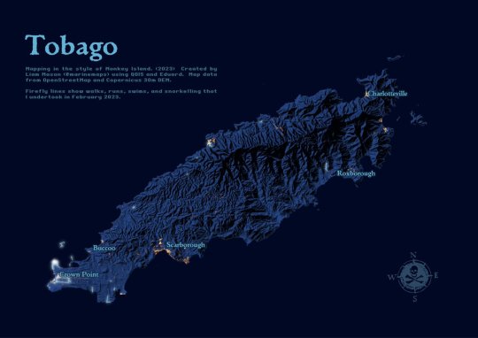
Tobago in the style of Monkey Island (with bonus firefly mapping).
by @marinemaps
48 notes
·
View notes
Text
@geoinquiets: RT @marinemaps: I'm frequently asked to display data on hydrographic charts, but these are navigational products, busy with symbols & text and raster-based. Here's an alternative vector basemap stack combining the @OrdnanceSurvey Zoomstack trial and @oceanwise_eu marine themes. https://t.co/SvYR910nXY
from http://twitter.com/geoinquiets
via IFTTT
0 notes
Photo

Known cold-water coral reefs west of Scotland and their associated MPAs.
More info: http://marine.gov.scot/information/cold-water-coral-reef
by @marinemaps
162 notes
·
View notes
Text
@geoinquiets: RT @undertheraedar: I've updated my 'All buildings in Great Britain' geodata page to include the whole lot in a single GeoPackage, plus everything as shapefiles as well, should you be into that kind of thing: https://t.co/GzAOU5SbPK thanks to @rjhale @fitnr @marinemaps @tjukanov for tips/reminders https://t.co/qe7oFBnOr1
from http://twitter.com/geoinquiets
via IFTTT
0 notes
Last Seen Blogs
doubleflorg
DBLFLRG

sarcasticgamerandwriter
Games and writing stuff

ashakhouski
Слово

alisdump
ali

whatever-i-draw
Whatever-i-draw