#chisos mountains
Text

Moon Over the Chisos by Tom Curry
#art#painting#chisos mountains#wolf#coyote#hare#jack rabbit#the moon#night#desert#desert at night#Texas#night sky
20 notes
·
View notes
Text
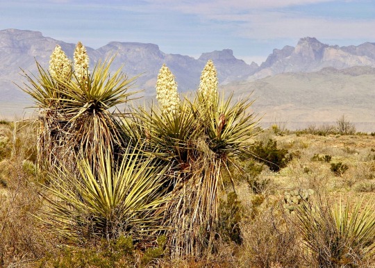
#big bend national park#chihuahuan desert#west texas#soaptree yucca#hiking#Chisos mountains#photo by me
12 notes
·
View notes
Text
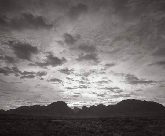
Chisos Mountains Sunrise, 1995
📸 Frank Armstrong
#chisos basin#chisos mountains#photography#original photographers#black and white photography#vintage photography#big bend#big bend national park#nature#texas#home#sunrise#terlingua#life#1995
5 notes
·
View notes
Video

flickr
Kit Mountain, Cliffs of the Sierra Ponce and the Santa Elena Canyon (Big Bend National Park) by Mark Stevens
Via Flickr:
A setting looking to the west while taking in views across desert and mountains present at Sotol Vista Overlook in Big Bend National Park. To create a panoramic, wide-angle image, I cropped a portion of the foreground and blue skies.
#1500 feet high#Azimuth 259#Big Bend National Park#Big Bend Ranges#Big Bend and Carlsbad Caverns National Parks#Blue Skies with Clouds#CaÐÑn de Santa Elena#Chihuahuan Desert#Chisos Mountains#Cliff Walls#Creosote Bush (Larrea tridentata)#Day 4#Desert#Desert Landscape#Desert Mountain Landscape#Desert Plant Life#DxO PhotoLab 5 Edited#Hillsides#Intermountain West#Kit Mountain#Landscape#Landscape - Scenery#Limestone Cliffs#Looking West#Looking into Mexico#Mesa de Anguilla#Nature#Nikon D850#No People#Outside
2 notes
·
View notes
Photo
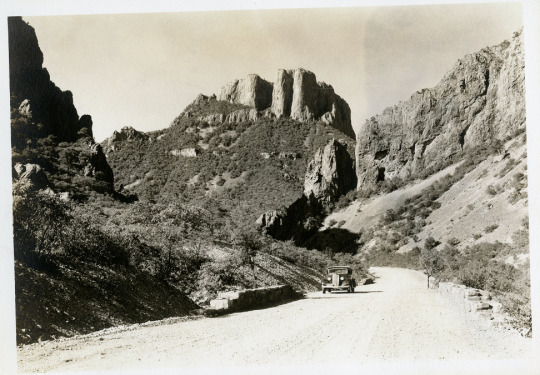
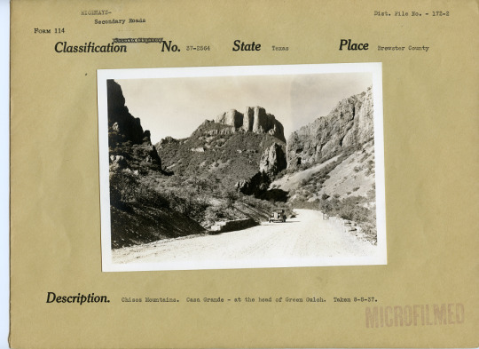
Chisos Mountains, Brewster County, Texas, 8/8/1937
File Unit: Highways - Texas, 1896 - 1963
Series: Historical Photograph Files, 1896 - 1963
Record Group 30: Records of the Bureau of Public Roads, 1892 - 1972
Image description: A dirt road winding through the Chisos Mountains, with Casa Grande peak in the background. A 1930s car is on the road.
Image description: Same photo, on a form with the caption, “Chisos Mountains. Casa Grande - at the head of Green Gulch. Taken August 8, 1937.”
30 notes
·
View notes
Text

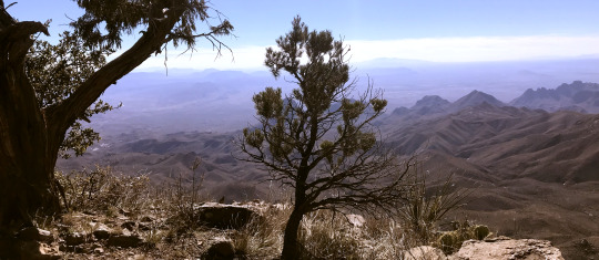
the chihuahan desert, 2024
#speaking#yuppp my photos 😁 i'm more of a draw-er than a photographer but well i tried. with my ten year old iphone because i didn't bring my camera#first is some random place second was taken on mesa de anguila third on the chisos south rim and fourth is carousel mountain Yayy
108 notes
·
View notes
Text
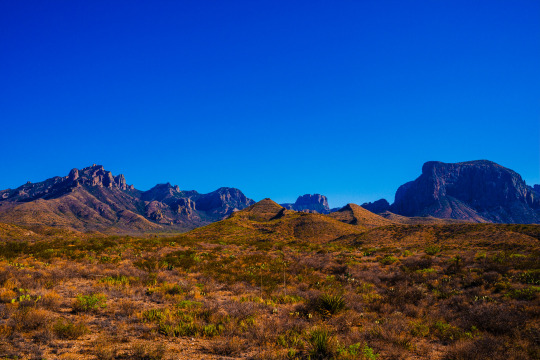
The Great Chisos Mountains, doesn't it scream; LET'S GO ON AN ADVENTURE?
This has got to be one of those photos that anytime I feel low, I look at and it just reminds me of why I am doing what I am doing.
Shot with the Fuji X-T4
#fujifilm#fujixt4#fujixseries#photography#travel#adventure#texas#bigbend#nationalpark#lonestar#lonestarstate#usa#summervibes#yeehaaw#wildwildwest#travelphotography#photograph#landscape#landscape photography#nature#naturephotography
21 notes
·
View notes
Photo

Chisos mountains at night 🌖 Pet memorial commission piece for Ash
305 notes
·
View notes
Text
BOTD: Colima Warbler
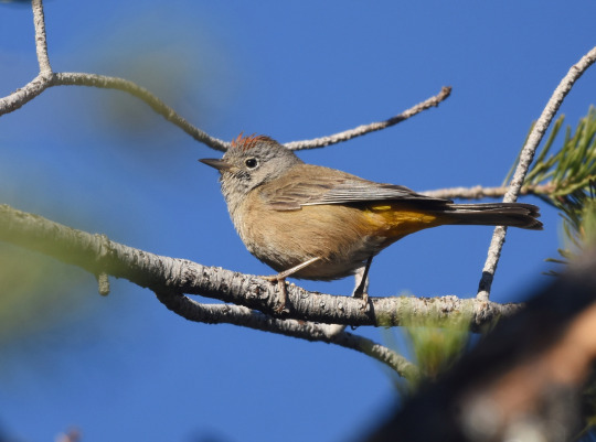
Photo: Christopher Lindsey
"In our area, this Mexican species occurs only in Big Bend National Park in western Texas. There it is fairly common in summer at upper elevations in the Chisos Mountains, but seeing it requires a day-long hike or a lengthy horseback ride. The Colima is larger than most warblers and tends to be sluggish, foraging deliberately in the dense undergrowth or in the lower levels of the oaks."
- Audubon Field Guide
#birds#colima warbler#birds of north america#north american birds#warblers#wood warblers#passerines#birds of mexico#birds of the us#birding#birdblr#birblr#bird watching#bird of the day#Leiothlypis crissalis
37 notes
·
View notes
Text
Warbler Showdown; Bracket 7, Poll 3
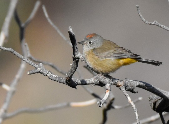

Colima Warbler (Leiothlypis crissalis)
IUCN Rating: Least Concern
Range: migratory; breeds in the Chisos Mountains in southwest Texas through the range in Mexico; overwinters in south central Mexico, from southern Sinaloa down to Oaxaca, though typically found in Colima and Morelos
Habitat: breeds in oak, Mexican pinyon, juniper, and Arizona cypress chaparral and overwinters in semihumid to humid montane forests.
Subspecies: none
Orange-crowned Warbler (Leiothlypis celata)
IUCN Rating: Least Concern
Range: migratory; breeds from Alaska to Newfoundland, all the way down to New Mexico, Arizona, and Baja California; overwinters in all southern states, along the Pacific Northwest, and in a majority of Mexico.
Habitat: breeding habitat is incredibly various due to range- brushy deciduous, fir-aspen, or pine-oak woodlands, harvested forests, and early-successional deciduous stands. Each of these habitats are associated with different tree types too, a true generalist. Overwinters in similar habitats.
Subspecies: 4
Image Sources: Colima (Jason Vassallo) OCWA (Matt Davis)
#NWW Showdown#colima warbler#orange crowned warbler#leiothlypis#parulidae#passeriformes#animal poll#bird poll#polls#(i kno they're boring and not gonna win but I have a soft spot for OCWA bc of banding)
13 notes
·
View notes
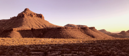
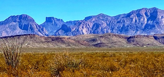
Photo

Casa Grande Peak, Chisos Mountains, Big Bend National Park, Texas.
163 notes
·
View notes
Text
Thinking about national parks now and how I'd love to go to more of them. I'm going to list the ones I've visited and a thing or two I remember about each of them.
Acadia: thunder hole and the rocky shores
Badlands: the prairie hike and the way you can hike off trail, scooting down a very steep descent on my butt because it was better than falling headfirst
Big Bend: hot springs, jays in the Chisos Mountains, Ross Maxwell Scenic drive and sunset near Santa Elena Canyon
Bryce Canyon: the sun hitting the hoodoos late in the day
Carlsbad Caverns: bats and the descent, learning about the ascent into Halloween Hall
Gateway Arch: I didn't realize this was a national park?? It's surprisingly narrow but it was interesting seeing the mechanism to get to the top.
Grand Canyon: on the north side black squirrels and a storm rolling in, on the south side the classic view
Grand Teton: sunrise against the mountains, getting caught between a moose and a bear on a trail
Smoky Mountains: the fall colors, the way the fog really is mysterious and thick and smoky
Guadalupe Mountains: Smith Spring and the transition from scrub to forest
Indiana Dunes: spending a day at the beach before it became a national park, the bog hike, taking a solo hike in the rain while my friends slept
Mammoth Cave: the ice-cream cone formation, a playground at the motel (i was very young)
White Sands: my deep desire to spot a lizard, the bright white of it all, admiration for people doing multi-mile hikes
Yellowstone: my dad wearing socks on his ears because we did not expect winter weather in June, Moose Valley, my brother and i picking out the smallest hot springs and naming them after ourselves
Yosemite: lots of big ravens, bridalveil fall viewed at a distance, sequoias
Zion: bighorn sheep, peeking into the narrows, promising myself i'd come back with people who aren't afraid of heights and hike angel's landing
#national parks#np diary#<- maybe i'll remember that tag (unlikely) and add to this if I get to visit another park
12 notes
·
View notes
Text
#big bend national park#chihuahuan desert#texas trans pecos#dike#casa grande#chisos mountains#purple mountains#hiking#photo by me
11 notes
·
View notes
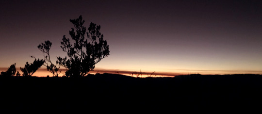
Text
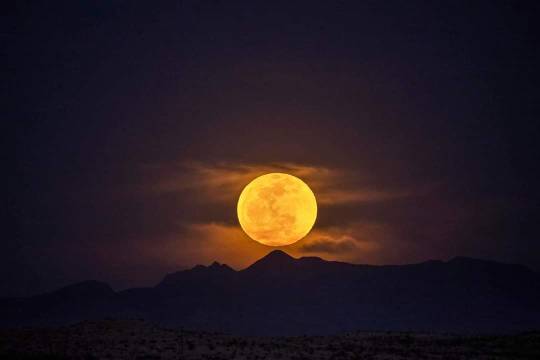
Supermoon over the Chisos Mountains
📸 Wayne Blissard
#big bend#terlingua#texas#west texas#photography#night photography#moon photography#supermoon#desert photography#desert#desert moon
62 notes
·
View notes
Video

flickr
Rainy Evening in the Chisos Mountains and Big Bend National Park by Mark Stevens
Via Flickr:
A setting looking to the northwest while taking in views across the Chisos basin area to The Windows in Big Bend National Park. While under an awning at the Chisos Mountains Lodge, I wanted to capture this setting of a rain storm that late afternoon and early evening. The overcast skies definitely brought more of a shadowed setting across the basin with only the more distant portions of the national park beyond The window still in sunlight. That was my thinking and composing this image and having the mountain view in silhouette be that focus towards the view beyond. I chose to work with Aurora HDR Pro to better bring that complete setting in this image. I later exported a TIFF image to DxO PhotoLab 5 where I did some final adjustments with contrast, saturation and brightness for the final image.
#Azimuth 290#Big Bend National Park#Big Bend Ranges#Big Bend and Carlsbad Caverns National Parks#Carter Peak#Chihuahuan Desert#Chisos Mountains#Chisos Mountains Lodge#Clouds Above#Clouds in Distance#Day 4#Desert#Desert Landscape#Desert Mountain Landscape#Desert Plant Life#DxO PhotoLab 5 Edited#Hillsides#Intermountain West#Landscape#Landscape - Scenery#Looking NW#Mountains#Mountains in Distance#Mountains off in Distance#Mountainside#Nature#Nikon D850#No People#Outside#Overcast
2 notes
·
View notes
Text
SPEAKING OF WILDFIRE, i wanted to share the fascinating-yet-terrifying article i read during work a few weeks ago. we get a daily newsletter of environmental-related new stories for our region's states, so i often find interesting things there.
This article honestly rocked me. I had NO idea the Austin-San Antonio area was at such a risk. I knew of the devastating fire in Bastrop, Texas a few years ago, and then more recently I followed the fires in the Chisos mountains in Big Bend National Park with personal interest since it's one of my favorite places in the world. But it hadn't really occurred to me that this area was such a risk waiting to happen. In retrospect, it does make sense to me (like, where did I think Bastrop was located if not close to Austin? lol)
I said earlier that I was fortunate to live in an area that doesn't experience much wildfire, and that's still true--I live in a region that is typically wetter and more humid than this. I mean, don't get me wrong, it's July and we're pretty crispy and dry over here too. But it's just not the same biome. We don't get massive sprawling wildfires--at most, someone burns their field off and it gets mildly out of control and put out within a day. Now, I trade this risk for being constantly under the gun for tornadoes all the time, but still. Fire is not a natural disaster that I worry about.
This article says that one-third of Austin is at high risk. The grasslands of the area don't produce super dramatic crown fires the way fires in California might, but since urban sprawl keeps steadily moving outward and embers from fires can go up to a mile away, the potential for damage is in the billions of dollars. It also says some of the towns and cities in Central TX don't even factor in fire during planning, and leave any fire mitigation up to the individual homeowner. Most of whom do not even realize that they are also living in fire country. And even if they do realize that and do take fire precautions, they're only as safe as all their neighbors are because of how quickly fire spreads from building to building.
In the I-35 corridor between San Antonio and Austin, nearly 1.1 million people (49% of the total population) are living in the wildland-urban interface (WUI) area that puts them at risk of wildfire since fires that start on open plains can easily consume new suburbs next to them.


7 notes
·
View notes
Last Seen Blogs

booksmusicandmagic-blog
BooksMusic&Magic

snapchat-me-january72012
January72012

thymeebutter
thyme

jackmaverick
Jack's Art Jamboree

irookis-blog
Life