#teleseismic
Text
Luana Piovani de calcinha
Alice March In Obsessed With My Step Brother
golosa Colombiana
Busty lesbians fingering and strapon fucking in threesome
Bare girl stands for cock and delights with amateur sex
sister swap her boyfriend at home and hard fucking after bored day
Fucked By Twin Sisters By Lady Fyre Pov Milf
muscle man fucks petite girl
Blindfolded sub Liz Rainbow choked and destroyed by Pascal
NOVINHA CHUPANDO E DANDO A BUCETA
#speculum#couchmaker#coetaneousness#impassionable#picture-pasted#becrawl#monastics#tweeded#soldierly#plafonds#unchaotically#aggrieved#preconfuse#railroadiana#teleseismic#cumulene#farcemeat#countervail#contadino#phosphamidon
1 note
·
View note
Text
Looking back at the Tonga eruption
“We showed that the eruption consisted of two distinct sequences of events, some of which occurred quasi-periodically in the first sequence. It will be worthwhile to investigate the mechanisms involved in such eruption cycles further,” says seismologist and geophysicist Yoshizawa.
The volcano generated seismic, tsunami and atmospheric waves that were recorded worldwide. Recent studies have estimated that it was one of the most energetic eruptions recorded by modern instruments.
“Eruption episodes are difficult to analyse fully from seismic surface waves, but we have teased out more details using what are called teleseismic-P waves,” says PhD student Tarumi. These are seismic waves that have travelled through the planet to locations distant from the eruption site. In this case, the team used seismic data collected from sites as far as at a 93-degree angle around the circumference of the planet.
The team’s “back-projection” analysis successfully detected the locations and timing of multiple explosions, even though P-waves from each eruption overlapped and were masked by other seismic signals and noises.
The back-projection technique reverses the transmission of seismic signals to reveal details of a potential source that radiated seismic waves. It was originally developed and applied for imaging the source processes of large earthquakes, but is now proving equally applicable to large scale volcanic events.
The results revealed that the sequence of eruptions occurred in two main parts. The first sequence began at 04:02 UTC on January 15, then escalated into major explosions at 04:15 UTC and 200 to 300 seconds after. The entire sequence lasted at least until 04:35 UTC. A second sequence of eruptions began about four hours later and continued from six to seven minutes, including a massive eruption at 08:31. Satellite imagery recorded the resulting dramatic ash cloud from the first eruption sequence, but until now the precise details of the underwater events have remained elusive.
One interesting finding was that significant explosive eruptions intermittently occurred at 270 to 280 second intervals, a frequency suggesting a resonance effect with the atmosphere and the Earth. “This apparent agreement of the eruption cycle and the atmospheric resonant oscillation with the Earth could be coincidental, but it certainly deserves further exploration,” Yoshizawa concludes.
0 notes
Photo
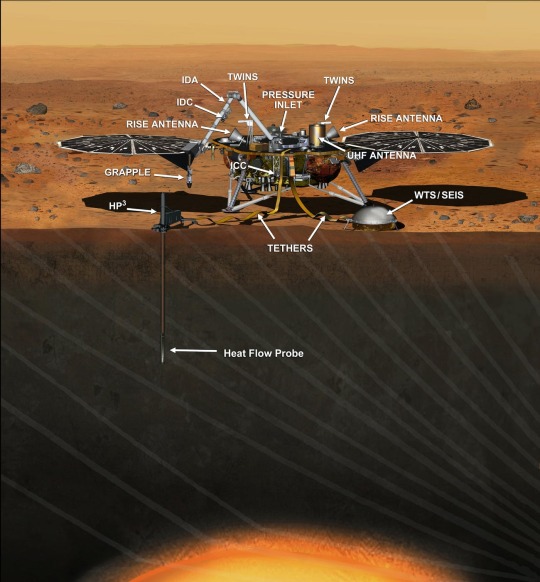

Seismicity on Mars full of surprises, in first continuous year of data The SEIS seismometer package from the Mars InSight lander has collected its first continuous Martian year of data, revealing some surprises among the more than 500 marsquakes detected so far. At the Seismological Society of America (SSA)'s 2021 Annual Meeting, Savas Ceylan of ETH Zürich discussed some of the findings from The Marsquake Service, the part of the InSight ground team that detects marsquakes and curates the planet's seismicity catalog. Marsquakes differ from earthquakes in a number of ways, Ceylan explained. To begin with, they are much smaller than earthquakes, with the largest event recorded at teleseismic distances around magnitude 3.6. SEIS is able to detect these small events because the background seismic noise on Mars can be much lower than on Earth, without the constant tremor produced by ocean waves. "For much of a Martian year, from around sunset until early hours, the Martian atmosphere becomes very quiet, so there is no local noise either," he said. "Additionally, our sensors are optimized and shielded for operating under severe Martian conditions, such as extremely low temperatures and the extreme diurnal temperature fluctuations on the red planet." Marsquakes also come in two distinct varieties: low-frequency events with seismic waves propagating at various depths in the planet's mantle, and high-frequency events with waves that appear to propagate through the crust. "In terms of how the seismic energy decays over time, the low-frequency events appear to be more like earthquakes" in which the shaking dies away relatively quickly, Ceylan said, "while the high-frequency events are resembling moonquakes" in persisting for longer periods. The vast majority of the events are high-frequency and occur at hundreds of kilometers of distance from the lander. "It is not quite clear to us how these events could be confined to only high frequency energy while they occur at such large distances," he said. "On top of that, the frequency of those events seems to vary over the Martian year, which is a pattern that we do not know at all from Earth." Only a handful of marsquakes have clear seismic phase arrivals--the order in which the different types of seismic waves arrive at a location--which allows researchers to calculate the direction and distance the waves come from. All these marsquakes originate from a sunken area of the surface called Cerberus Fossae, about 1800 kilometers away from the InSight Lander. Cerberus Fossae is one of the youngest geological structures on Mars, and may have formed from extensional faulting or subsidence due to dike emplacement. Recent studies suggest extension mechanism may be the source of the Cerberus Fossae quakes, Ceylan noted, "however, we have a long way in front of us to be able to explain the main tectonic mechanisms behind these quakes." The biggest challenge for The Marsquake Service and InSight science team has been "adapting to unexpected signals in the data from a new planet," Ceylan said. Although there were significant efforts to shield SEIS from non-seismic noise by covering it and placing it directly on the Martian surface, its data are still contaminated by weather and lander noise. "We needed to understand the noise on Mars from scratch, discover how our seismometers behave, how the atmosphere of Mars affects seismic recordings, and find alternative methods to interpret the data properly," said Ceylan. It took the Service a while to be "confident in identifying the different event types," he added, "discriminating these weak signals from the rich and varied background noise, and being able to characterize these novel signals in a systematic manner to provide a self-consistent catalog." The InSight seismicity catalog and data are released to the public via IPG Paris, IRIS, and PDS on a three month schedule, with three month data delay.
3 notes
·
View notes
Text
A new way to identify a rare type of earthquake in time to issue lifesaving tsunami warnings
by Valerie Sahakian

This unusual earthquake type generates an outsized tsunami. camila castillo/Unsplash, CC BY-ND
Just a few times in a century, somewhere on the globe, a rare “tsunami earthquake” occurs. These are mysterious because, while they’re just medium-sized as earthquakes go, they cause disproportionately large and devastating tsunamis. This type of midsized earthquake is very different than an event like the 2004 earthquake in Sumatra – a very big magnitude 9.2 event which unsurprisingly produced a huge tsunami.
The most recent tsunami earthquake happened in 2010. A magnitude 7.8 earthquake off the Mentawai Islands in Indonesia set off a tsunami that was over 50 feet in height in some places – much greater than seismologists would predict based just on the earthquake’s size. 509 people were killed, and 15,000 more were displaced or left homeless.
Tsunami earthquakes are particularly destructive and dangerous because the massive tsunami waves can hit local coastal communities within just five to 15 minutes – before officials can issue a warning. But based on our analysis of previously unavailable closeup observations of the 2010 Mentawai event, my colleagues and I think there is a way to determine that an event is a tsunami earthquake in time to warn people that an unexpectedly large wave is on the way.
Earthquakes under the ocean
The Earth’s surface is made up of floating tectonic plates that fit together like a slightly imperfect jigsaw puzzle. These plates are moving next to, under or away from each other.
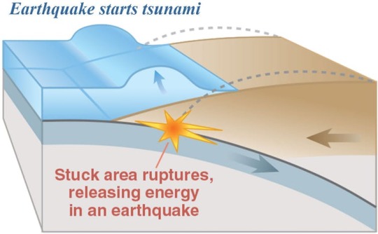
An earthquake along a subduction zone happens when the leading edge of the overriding plate breaks free and springs seaward, raising the seafloor and the water above it. This uplift starts a tsunami. USGS
In a subduction zone, one tectonic plate is sinking beneath another. This builds up stresses over time and will eventually create an earthquake. Most typical subduction-zone earthquakes occur roughly 10 to 30 miles down, in an area where the rocks are rigid and strong on the fault between the two tectonic plates.
Meanwhile, the shallowest area of a subduction zone, closest to the seafloor, is made up of soft sediments that are not very strong. Earthquakes rarely occur only here, because stresses mostly don’t build up in these soft, weak rocks.
Geoscientists define an earthquake’s overall size with its magnitude. Earthquake magnitude describes how much “work” is accomplished by the earthquake moving the fault – more work for either more movement, or for moving more rigid rock.
Very large earthquakes, like the magnitude 9 Tohoku earthquake in Japan in 2011, are so big that they break the deeper part of the subduction zone, but also continue upwards to break the shallow part of a subduction zone. This rapid earthquake motion moves the seafloor and creates a tsunami.
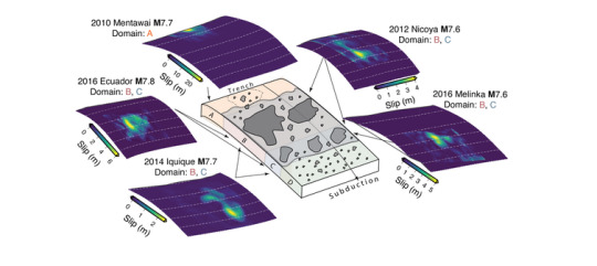
Cartoon depicting the amount of movement in five earthquakes. The 2010 Mentawai tsunami earthquake moved the fault much more – over 65 feet compared to about 15 feet for the others – and the movement occurred much closer to the seafloor than in any of the other earthquakes. Sahakian et al. (2019), GRL
What sets tsunami quakes apart
“Tsunami earthquakes” are strange in that they happen almost entirely in the soft, weak section of the fault.
Because tsunami earthquakes break such soft rock, they happen slower, and create much more movement on or near the seafloor in comparison to a normal subduction-zone earthquake of the same size that happens in rigid rock. This in turn creates a much larger tsunami than expected.
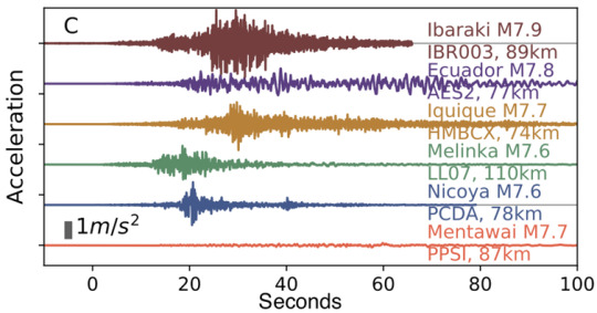
Seismograms showing how much the ground shook from six similarly sized earthquakes, at seismometers all about the same distance from their earthquake. You’d expect the shaking to be comparable. The 2010 Mentawai earthquake seismogram is at the bottom in orange, and shows significantly less shaking than any of the others. Modified from Sahakian et al. (2019), GRL.
A tsunami earthquake might have the same magnitude as an earthquake that occurs in rigid rock but produces much less of what seismologists call high-frequency energy.
Think of breaking a thick slab of concrete – which is strong and would produce an audible bang with both low and high-pitched noise – versus breaking a loaf of bread, which makes almost no sound at all. In the Earth, “sound” is the shaking you feel under your feet. The soft bread break is like a tsunami earthquake that doesn’t release a lot of high-frequency energy, and thus doesn’t create as much shaking as we would expect for its magnitude.
Sensing quakes in time to warn
Currently, officials rely on knowing an earthquake’s magnitude and location to issue tsunami warnings within tens of minutes. But this doesn’t work in the case of tsunami earthquakes, because the earthquake’s magnitude doesn’t match up with the size of the tsunami it produces.
Instead, to figure out whether an earthquake is in fact a tsunami earthquake, scientists compare its seismic magnitude measured from afar with the amount of high frequency radiated energy it produced, as recorded by far away stations.
If the ratio of energy to magnitude is very low, it’s a tsunami earthquake – basically, its shaking was far too weak for its magnitude because it was breaking soft rock. Instead, its energy is of the low-frequency type: Rather than strong shaking, its energy goes into large slow movement of the seafloor and the ensuing tsunami.
The problem is that in the past, scientists had never recorded one of these elusive earthquakes closeup in what we call the near-field – within about 180 miles (300 kilometers) or so. Instead, scientists have had to find an earthquake’s energy-to-magnitude ratio using seismic waves that have traveled all the way from the epicenter of the earthquake across the world to where researchers can measure them. This process is relatively slow, so we haven’t been able to identify tsunami earthquakes quickly enough to warn people in time, before the wave hits the coast.
Now my colleagues and I have for the first time analyzed data recorded by seismic stations that happened to be near the epicenter of the 2010 Mentawai earthquake. We think we have figured out a new way to identify the danger of a future tsunami earthquake, faster.
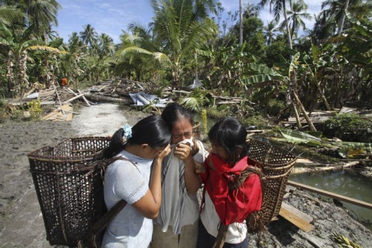
Tsunamis can take a terrible toll, as for this Indonesian family that lost their father and their home in the Mentawai disaster. AP Photo/Tundra Laksamana
Closer and quicker proxies
Our new study used the same concept of comparing the energy released by an earthquake to its seismic magnitude – but based on data from geographically close to the event. Instead of looking at energy measurements recorded at a distance, we used two proxies.
To look directly at how much the ground shook, we used seismic stations onshore near the epicenters of 16 earthquakes, including the Mentawai one in 2010. Because the amount the ground accelerates when seismic waves pass through illustrates how much high frequency energy is in the earthquake, this information was a stand-in for the data we would traditionally get from the far-flung teleseismic stations. Low accelerations mean little high frequency energy.
For the normal earthquakes we looked at, the accelerations from near-field seismometers were close to what we’d expect for each earthquake’s magnitude. In comparison, the 2010 Mentawai earthquake’s accelerations were closer to what we would expect for a magnitude 6.3 earthquake – whereas the earthquake was actually a magnitude 7.8, and produced a tsunami we’d expect for an event of greater than magnitude 8.
We also looked at GPS stations close to the earthquakes. They can show us how much the ground actually moved or was displaced, and measure the earthquake magnitude itself.
Using these measurements together allowed us to compare the amount of energy in the earthquake with respect to its magnitude – without waiting for the seismic waves to travel across the globe. Instead, we would have been able to identify a tsunami earthquake immediately by looking at how low the accelerations were on local seismometers in comparison to the magnitude of the earthquake based on GPS readings.
We think our finding is really promising because these near-field measurements are available immediately – even while an earthquake is happening. Seismologists could use this approach in the future, to identify a tsunami earthquake right after it happens, and provide warning to the nearby coast before the tsunami wave arrives.

About The Author:
Valerie Sahakian is an Assistant Professor of Geophysics at the University of Oregon
This article is republished from our content partners over at The Conversation.
17 notes
·
View notes
Text
electrician for hire near me Kirkland Lake Ontario
Contents
Gordie howe international bridge
Middle-aged couple living
Sault ste. marie
Electric electrician. great
Windsor, Ontario Representatives from Windsor-Detroit Bridge Authority (WDBA), its private-sector partner, Bridging North America as well as the State of Michigan and the Government of Canada, unveiled a comprehensive and robust Community Benefits Plan for the gordie howe international bridge project. The Community Benefits Plan is comprised of two components: the Workforce.
handy electrician near me Wasaga Beach Ontario Myanmar Trip 2007 – Blogger – Debbie and I are a middle-aged couple living in Wasaga Beach, Ontario, Canada about two hours drive north of Toronto. For years we lived in downtown Toronto. I worked for the provincial government and Debbie owned and operated a boutique travel agency.find electrician near me Sioux Lookout Ontario There are couples, young and old, and a few single travelers like me. There’s an air of excitement and expectation. I head back to my cabin, tired from a hard day of sightseeing. I awake to find we.certified electrician near me sault ste. marie Ontario find electrician near me Thornhill Ontario Alex Electric-Electrical Contractor. "Professional electrician dedicated to providing comprehensive and efficient service in a timely manner.No job too small! alex electric-electrical contractor – Thornhill, ON, CAList of the best Electrical Contractors in Sault Ste. Marie, ON. Get free custom quotes, customer reviews, prices, contact details, opening hours from Sault Ste. Marie, ON based businesses with Electrical Contractors keyword.
Kohut Electric Ltd in Kirkland Lake Ontario, is an an electrical service company specializing in both commercial and residential electrical installation and repairs as well as alarm services, geothermal ground source heat pumps,electrical repairs and much more!
Nedco is one of the largest electrical wholesale suppliers providing a wide range of products for residential electricians and commercial contractors and large industrial organisations across Canada. We carry comprehensive product solutions for Lighting, Datacom, Wire & Cable, Power Management and
Teleseismic studies of the lithosphere below the Abitibi-Grenville Lithoprobe transect
If the guy tells you his 4000 psi machine can clean your roof super fast and not do any damage, hire someone else. And call me. I’ll set up a personal consultation so you can ask your own questions of.
Mr. Electric is available on your schedule, 24 hours a day, seven days a week. Quality Assured. Our courteous technicians respect your home and family, providing an attention to detail that ensures quality, and safe work. Upfront Pricing. Mr. Electric electricians always explain what they are going to do – before any work starts.
Allelectricalproducts – electrician near me free estimate Waterloo Ontario electrician s near me Kirkland Lake Ontario For Sale: P2H.Price.PriceOffer – Multi-family, bed, bath, sqft at 121 Duncan AVE in Kirkland Lake. $89,000 CAD: Live in one side and rent the other side! This front and back duplex with two three bedroom units is a sound investment.read real reviews and see ratings for Waterloo, IA Plumbers near.
local electrician near me Barrie Ontario Barrie Electrician & Electrical Contractors.. Our Barrie Electricians have rejuvenated the aluminium wiring in many homes in this area providing a permanent solution for a home wired using aluminium.. your local barrie electrician you can count on us to be on time, prepared and respectful.
Chatham, Ontario 68 Electricians near you. Go . StarOfService Ontario Chatham Electricians. Hire the best Electricians . in Chatham . 1. Rob’s electric electrician. great Lakes Electric Inc , Chatham, Ontario, 5198094532 Electric SHIP PARTS. Here are some ship parts we currently have listed for sale.
from Callander Ontario hire electrician - Indianelectrics https://www.indianelectrics.com/electrician-for-hire-near-me-kirkland-lake-ontario/
via https://www.indianelectrics.com
0 notes
Text
Effect of induced seismicity on advanced gravitational wave interferometers. (arXiv:1811.11817v2 [astro-ph.IM] UPDATED)
Advanced LIGO and the next generation of ground-based detectors aim to capture many more binary coalescences through improving sensitivity and duty cycle. Earthquakes have always been a limiting factor at low frequency where neither the pendulum suspension nor the active controls provide sufficient isolation to the test mass mirrors. Several control strategies have been proposed to reduce the impact of teleseismic events by switching to a robust configuration with less aggressive feedback. The continental United States has witnessed a huge increase in the number of induced earthquake events primarily associated with hydraulic fracking-related waste water re-injection. Effects from these differ from teleseismic earthquakes primarily because of their depth which is in turn linked to their triggering mechanism. In this paper, we discuss the impact caused due to these low magnitude regional earthquakes and explore ways to minimize the impact of induced seismicity on the detector.
from gr-qc updates on arXiv.org http://bit.ly/2VpxJHX
0 notes
Text
A Geothermal Plant Likely Caused South Korea’s Second-Worst Earthquake
Subterranean tremors caused by an experimental geothermal plant may have triggered South Korea’s second-worst earthquake in its history.
This is according to a government-commissioned study of the November 2017 disaster in the city of Pohang, when a 5.4 magnitude quake crumbled the city and injured dozens of people. The study concluded that activity at a geothermal plant, which injects water underground to stimulate thermal energy production, likely caused the disaster.
“A series of micro-sized earthquakes occurred when fluids were injected by excavating a geothermal well at the geothermal power plant, which eventually triggered the Pohang earthquake,” Lee Kang-keun of Seoul National University, who co-led the study, told The Korea Times on Wednesday.
“We use the word ‘trigger,’ as the earthquake occurred beyond the scope of stimulated area,” Lee added. “It was not a natural earthquake.”
Two studies published to Nature in 2018 strongly suggested that a geothermal plant was to blame for the destructive earthquake.
The first, conducted by South Korean researchers found that “the Pohang earthquake was induced by fluid from an enhanced geothermal system (EGS) site,” the magnitude of which “makes it the largest known induced earthquake at an EGS site.”
A second study by a team of international researchers concluded that, based on “local seismometer network, well logs, satellite observations, teleseismic waveform analysis, and stress modeling leads,” the Pohang quake was “almost certainly” anthropogenically induced.
“If the Pohang earthquake is really induced, it’s a kind of game-changer in the hydro-geothermal power plant industry,” Jin-Han Ree, a structural geologist at Korea University in Seoul and lead author of one of the studies, told Nature News at the time.
As noted by Nature News, the type of geothermal plant in Pohang was notable for extracting thermal power from “less-ideal locations,” and that at least some seismic activity is to be expected.
Such geothermal systems work by creating subsurface fractures deep underground that water will permeate through injection wells. The earth’s crust heats this water, which then returns to the surface to power a turbine and generate electricity. An EGS fact sheet produced by the US Department of Energy claimed that any resulting seismicity events “are of such low magnitude that they are not felt at the surface.”
An EGS project in Fenton Hill, New Mexico was built and later discontinued due to budget cuts in the 1990s. Several new projects are currently in early stages in the US.
By now, geothermal fluid injection is known to cause earthquakes—such as the 3.4 magnitude quake that hit Basel, Switzerland in 2006, damaging the city’s buildings and infrastructure. And the fear now looms over communities living near geothermal outfits in the United States.
The South Korean government will be permanently suspending the plant, reported South Korean broadcaster KBS World Radio News. The government will also spend 226 billion won (roughly $200 billion USD) over five years to repair damage in parts of Pohang that were hit hardest by the quake.
A Geothermal Plant Likely Caused South Korea’s Second-Worst Earthquake syndicated from https://triviaqaweb.wordpress.com/feed/
0 notes
Text
Teleseismic traveltime tomography of northern Sumatra
Abstract We imaged the mantle structure beneath northern Sumatra by inverting high-quality seismic arrival time data and using a newly developed eikonal equation-based teleseismic tomography method. Traveltime differences between neighboring stations
source https://www.environmentguru.com/pages/elements/element.aspx?utm_source=www.environmentguru.com&utm_medium=rss&id=8955943
0 notes
Link
0 notes
Text
Evidence for Rg-to-P scattering in teleseismic P coda of East Kazakh explosions
http://dlvr.it/PMnTq9
0 notes
Text
P and S Wave Receiver Function Imaging of Subduction With Scattering Kernels
Abstract A method for scattered wave imaging in 3-D with both teleseismic P and S wave receiver function data is introduced. The approach relies on body-wave scattering kernels that are derived from the adjoint data sensitivity kernels which are typi https://www.environmentguru.com/pages/elements/element.aspx?utm_source=dlvr.it&utm_medium=tumblr&id=6021691
0 notes
Text
P- and S-Wave Receiver Function Imaging of Subduction With Scattering Kernels
Abstract A method for scattered wave imaging in 3D with both teleseismic P- and S-wave receiver function data is introduced. The approach relies on body-wave scattering kernels that are derived from the adjoint data sensitivity kernels which are typi https://www.environmentguru.com/pages/elements/element.aspx?utm_source=dlvr.it&utm_medium=tumblr&id=5850181
0 notes
Text
Seismic High Attenuation Region Observed Beneath Southern New England From Teleseismic Body Wave Spectra: Evidence for High Asthenospheric Temperature Without Melt
Abstract Seismic attenuation exhibits strong geographic variability in northeastern North America, with the highest values associated with the previously recognized Northern Appalachian Anomaly (NAA) in southern New England. The shear wave quality fa https://www.environmentguru.com/pages/elements/element.aspx?utm_source=dlvr.it&utm_medium=tumblr&id=5786652
0 notes
Text
Seismic high attenuation region observed beneath southern New England from teleseismic body wave spectra: evidence for high asthenospheric temperature without melt
Abstract Seismic attenuation exhibits strong geographic variability in northeastern North America, with the highest values associated with the previously-recognized Northern Appalachian Anomaly (NAA) in southern New England. The shear wave quality fa https://www.environmentguru.com/pages/elements/element.aspx?utm_source=dlvr.it&utm_medium=tumblr&id=5651023
0 notes
Text
Investigating dynamic triggering of seismicity by regional earthquakes: the case of the Corinth Rift (Greece)
Abstract Dynamic triggering has been commonly observed after large teleseismic events, but the physics behind it is still under debate. To broaden observations, we here focus on the dynamic triggering by regional earthquakes, i.e. by events with magn https://www.environmentguru.com/pages/elements/element.aspx?utm_source=dlvr.it&utm_medium=tumblr&id=5630071
0 notes
Text
Mantle dynamics beneath the discrete and diffuse plate boundaries of the Juan de Fuca plate: Results from Cascadia Initiative body wave tomography
Abstract We use the delay times of teleseismic S phases recorded by ocean bottom seismometers during the plate-scale Cascadia Initiative community experiment to constrain the heterogeneity of seismic velocity structure beneath young oceanic lithosphe https://www.environmentguru.com/pages/elements/element.aspx?utm_source=dlvr.it&utm_medium=tumblr&id=5582955
0 notes
Last Seen Blogs

frafizadeh
Untitled

meister264
Untitled

noahwright
dumb of ass.

coordinationcheckcashij
Fast small loans farther profitable amazon affiliate

martelsre
Untitled