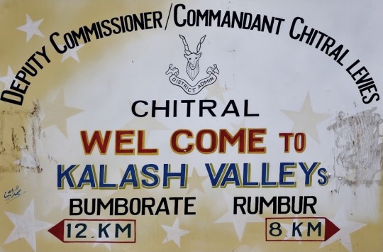
#rumbur
Text
MYSTERY POST #22
Abay Acon Aesh Afjord Agance Agfish Agnon Akron Akropto Aldralma Alin Alish Allfism Almusite Altio Amark Ammyshite Anchuari Angae Angire Anoi Anzanky Aroaconce Ashu Assicholk Auftotics Aulk Auqina Autcand Aven Avey Avvan Ayte Baaditer Baba Bacism Balcish Balliten Barth Basene Bastita Batrism Baygati Beatum Beber Belay Bera Bersocup Besh Biin Bism Bite Blairite Blaspa Blewebo Bophetite Bordena Bramad Branske Brine Broch Brop Brosite Brucke Bubbiesh Buchel Bucken Bunarake Burde Burian Burven Butite Cachrang Cale Calia Caliando Calottite Camite Cander Cang Capmose Carbanite Carite Carutate Cather Cedranite Celad Centon Cercerite Chabaimus Charite Charrism Chelous Chelton Chence Cherism Chetad Chip Chite Chityle Chou Chri Chritsa Chrober Cielen Clady Cles Coleold Conjack Consal Coonic Copezz Copop Cord Cordie Coressite Crus Crussenso Cubite Cultonite Curdote Daegark Dagne Dalite Dane Dançois Daophil Dind Dite Diveite Dixonnism Djiandez Dmanne Doga Dord Dors Dotwila Duarbeadi Duchino Duse Dviper Ection Edmudeve Egonite Elydrium Eolfore Esnake Exce Fanite Fayyanish Fergite Fish Fisolun Fiste Fonelezer Fonite Forite Fragnite Fraite Fraja Fres Friterber Fuckarden Fundance Fuske Gandal Gaprotter Gard Gary Gastang Gees Gencibish Gencorne Gene Gensven Geri Gericite Ghonnite Ghte Gina Gite Glaite Gord Grite Gueel Guss Hakha Hancan Heitic Helaite Herope Hiterrite Hoblesa Hricar Hulive Iběna Ijie Imen Inden Inewing Ingsid Iong Ismianti Izmirgale Jacitersh Jactry Jassu Jeaden Jeagaliny Jefiste Jell Jewtolder Jiash Jill Jordenite Jorderose Jorich Kalphobfe Kalticel Kaozim Kard Katsnance Khanch Kimiper Kite Koindance Korrik Kraq Kröck Kurasm Lark Laylve Lazzbur Leouack Leste Libon Lillega Liperoido Lite Logish Lookish Loph Loution Ludil Ludro Luorne Lusichie Lusite Lygle Lywherne Macrakerd Magero Mainsite Malite Mall Manaste Mancleez Mara Marite Mariy Mark Matgre Mation Matite Mcase Mccout Mckite Mcolk Medrapso Merse Metla Meydrite Miandusel Midamptin Mirad Mism Mite Mock Monimen Moottetts Mordery Moutonite Mumborden Muorseel Nastish Nate Neid Neponi Nern Nistilk Nite Nitredan Noedson Nuckall Oacite Ocin Olyandamb Oselie Oson Ovite Palger Panez Panifeez Pardeme Parego Parfism Paroch Pash Patic Payya Pelling Peno Perimer Phite Phosh Piandd Pien Pislocksh Plakre Poweez Powilite Powne Pras Pretibbon Prite Pyrren Pyte Quez Radaltall Rens Rhen Rhuez Roon Rornie Rosanite Rostobre Rounte Rovegroil Rumbur Rumsh Runfjorey Runk Ruse Saddealm Saktise Saluo Sambra Sang Sanneyite Sart Scon Sele Shiphea Sillar Site Sitermaru Sitodwala Skassite Skophave Snaoperal Sobie Song Sorduake Spher Stanong Stia Stotcorp Suite Sukeeite Suntash Suvil Sward Swel Swer Swick Symite Syne Sypine Sysodidd Tackeh Tacrea Taimegar Takiper Tallite Tapop Taranzan Tetite Tety Thard Theylexte Tinsite Tompke Trank Trite Troldez Troussite Tsrus Turite Ulfghte Uliv Utrionpop Uwarrite Vadfar Vard Vauda Vayso Vechiber Verick Viantish Vite Walcoophy Walush Wambilla Wate Wavive Weerite Weingmah Wellup Weres Wersanikl Whitlega Wile Willu Wimekae Wores Wospord Xenbonite Xenbrum Yanclémy Yelens Yonke Yopetad Zaolite Zenord Ziranny Zite Zorons Zussite Zürgite Éliscup Élène Étarna Évena Økspe
1 note
·
View note
Video
youtube
Rumbur Valley Kalash Drone Video | First Ever Drone Video of Kalash Vall...
1 note
·
View note
Video
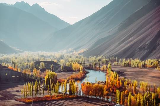
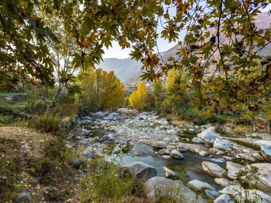
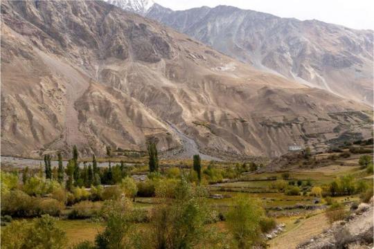
Rumbur Valley, Pakistan
#mountain streams#rumbur#kalash valley#rombur#pakistan#chitral#nwfp#afghanistan#kafiristan#kalash#kalasha#hindu kush#FIRST-THEEARTH!#unature#unaturefav#Rumbur Valley
29 notes
·
View notes
Photo
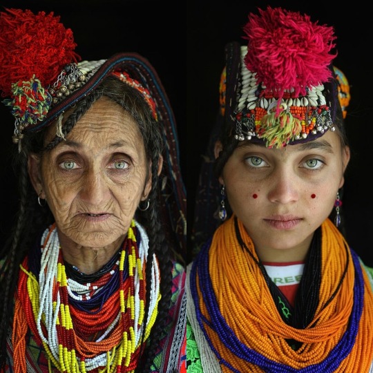
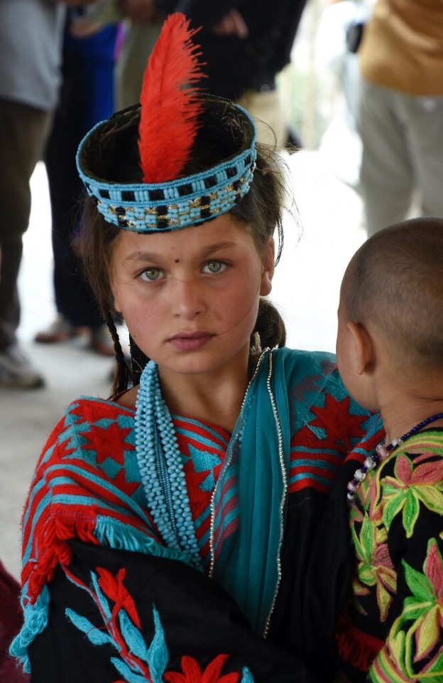
Abi Gul and her Grandmother Bibi Kai of the polytheistic Kalash Tribe, Chitral village of Rumbur, PK - See more viral images on ViralTiger.org
0 notes
Link
Kalash Valley- KPK Pakistan | Pakistan Travel Packages | Tour and Trips
Kalash is consists of three villages namely Rumbur, Bomborate and Birir. Collectively it is called as Kalasha Valleys and famous for it's tradition, culture and way of life of the kalasha people. They have the ancient values of living standards, apart from this they are known for Their own religion and customs, they are quite different in religion, customs, culture and tradition from rest of World, which makes them unique.
...
We as Hunza Trek & Tours licensed from Govt. of Pakistan offering the World, several tour types i.e. Adventure and Expedition, Culture and History, Trekking and Hiking, Archeology and Heritages, Sightseeing and Roundtrips in Pakistan especially in the World's Highest Mountain Ranges namely Karakorum, Himalayas and Hindu Kush lies in Northern Part of the Country. Our product/activities are all inclusive from any given /suggested pickup point and back. accommodation, transport, meal (B.L.D), domestic flight tickets, toll and taxes.
#pakistan#travel#trips#tour#tour operators#travel pakistan#explore#explore pakistan#holidays#vacations#summers#culture#tradition#history#gilgitbaltistan#islamabad#lahore#trippy#lonely planet#adventure#wander#wanderlust#travel blogger#girls#picoftheday#vloger#family trip#group trips#solo trip#love
2 notes
·
View notes
Text
5 Mesmerizing Sides Of Pakistan
Pakistan is a beautiful country. Home to 108 peaks above 7,000 meters, including K2, the south Asian country’s mountain scenery is stunning. From the lively cities like Islamabad and Lahore to the beautiful valleys in the north, Pakistan is a perfect place for a unique getaway. Pakistan is the home of mermerizing beauty and infinite culture.
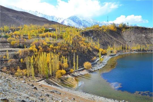
Kalash Valley
Deep in the mountains along the Pakistan-Afghanistan border, the remote Kalash Valley (also sometimes called Kalasha Valley is home to Kalasha people. Pakistan’s Kalash Valleys, comprised of Bumburet, Birir, and Rumbur are hidden gems surrounded by the dramatic Hindu Kush mountain range, a part of the Himalayas. The craggy summits are covered with juniper and birch scrubs, providing spectacular natural views. The valleys are well-known for their people's attractiveness as well as their natural beauty.
Bumburet is the most populated valley and popular with Pakistan tourists. Rumbur and Birir are less developed and popular with foreign travelers. Visit the locally-owned Kalasha Dur museum in Bumburet, an attractive cultural museum that gives you all the information needed to tour the stunning valleys.
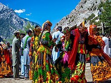
The best time to visit the Kalash Valleys is during one of their traditional festivals. Chilan Joshi is held in May, Uchau is celebrated in autumn, and Choimus occurs for two weeks around the winter solstice. Tourists are always amazed at the colorful costumes, rituals, drink, and dance. Kalash valley tour is one of the top cultural retreats of Pakistan. Kalash valley tour provides an amazing cultural experience in the Hindukush mountain ranges among the ethnic minority community of Kalash.
Skardo
Skardu, capital of Baltistan is perched 2,438 metres above sea level in the backdrop of the great peaks of the Karakorams.Balti people are a mixture of Tibetan and Caucasian stock and speak Balti, an ancient form of Tibetan. Due to the similarity of its culture, lifestyle and architecture with Tibet, Baltistan is also known as the "Tibet-e-Khurd" (Little Tibet).Skardu valley is endowed with resorts, lakes, a fort, and a cold desert, all of which are breathtakingly beautiful. Skardu, the central valley of Gilgit-Baltistan in Pakistan is a paradise of beauty, peace, and wilderness. This valley connects paths to some of the world's highest mountains, including K2, K3, and Gasherbrum.
The valley's beauty is enhanced by its fresh spring water, delicious fruits, the blue water of the Indus River, historical sites, lakes, and pleasant weather, which draw visitors from all over the world.
KERTHAR AREA
KIRTHAR is home to some unique and special wildlife species, flora and heritage. It is Pakistan’s second largest park and also on the UN’s list of international parks.The Kirthar range stretches from Sindh to Balochistan, serving as a natural border between the two provinces. This mountain range includes the scenic Gorakh Hill (5700), Kutte Ji Qabar (6877) and Bandu Ji Qabar (7112).
This region is not just known for its breathtaking beauty but also for its rich history. Spread across 150 miles, it is an ideal tourist spot due to several streams, springs and historic locations, however, it’s unfortunate that few tourists prefer to visit. The local population is eager to welcome visitors and want to make this area a better place.
Fairy Meadows
Nestled in the raikhot valley, high in the himalayas, it's easy to see why this lovingly green mountain paradise at the foot of a magnificent snowy peak was dubbed fairy meadows.Locals call it "Joot," but German mountaineers, who were no doubt astounded when they first saw this idyllic landscape, gave it the name Märchenwiese (literally "Fairy Tale Meadows"). Locals call it "Joot," but German mountaineers, who were no doubt astounded when they first saw this idyllic landscape, gave it the name Märchenwiese (literally "Fairy Tale Meadows").
The journey to Fairy Meadows necessitates bravery and stamina. The journey to Fairy Meadows necessitates bravery and stamina. The journey to Fairy Meadows necessitates bravery and stamina.but when you reached once the beautiful tranquility of the natural setting, the wonderful hospitality and stunning views of Nanga Parbat forget you each and everything and get lost in the breathtaking beauty of fairy meadows.
In Pakistan, a Fairy Meadows is a must place to visit. Fairy Meadows is one of the most popular and beautiful places to hike in Pakistan and for good reasons. Fairy Meadows is best to visit between April and May or September and October, preferably on weekdays, because these are considered the shoulder seasons, and while the weather may be a little colder than during the midsummer months, you are more likely to have the place to yourself.
Deosai Plains
Deosai is located on the boundary of Karakoram and the western Himalayas, and at no point it is less than 4000 meters above sea level. It remains covered with snow for 8 months. The rest of the year, it hosts a range of beautiful flowers of all hues and colors, but not a single tree is found in this plateau spread over 3000 sq. km.
The weather in quite unpredictable here, sometimes it starts snowing in summer. Sunlight and clouds seem to play hide and seek here, with the sun shining one minute, and overcast in next.
Sheosar Lake a part of deosai plains is one of the world's highest lakes. In the summer, the deep blue lake, with snow-covered mountains in the background and foliage with wild flowers in the front, provides such a vision that one is entertained for the rest of his life.
There are various springs in Deosai that are teeming with trout fish that serve as food for both villagers and bears. The actual beauty of Deosai is the backdrop of 5000 metre high mountains, fauna living in these mountains, clouds so low that one can nearly touch them, Himalayan Golden eagles flying between the clouds, and a weird aroma in the atmosphere that is presumably a blend of brown bears, red foxes, white tigers, and mischievous marmots.
1 note
·
View note
Photo
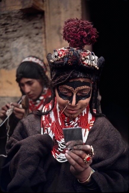
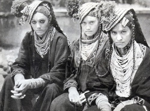

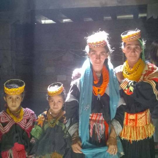
138) Kalasze (Chitral) (endonim: Kalasza), Kalash people, Kalasha (Kalasha: کاࣇاشؕا, romanised: Kaḷaṣa; Kalasha-ala: Kalaṣa; Urdu: کالاش), Kalash, Waigali, Wai – grupa etniczna licząca około 6000 osób, wyznająca odrębną archaiczną religię politeistyczną (ma około 3000 wyznawców; pozostali wyznają islam). Zamieszkują doliny Rumbur, Bumboret i Birir w masywie Hindukusz, na południe od miasta Czitral w Północno-Zachodniej Prowincji Granicznej w Pakistanie. Kalasze są jedyną grupą ludności praktykującą prastarą religię politeistyczną, jaka przetrwała na ogromnym obszarze islamskim od Turcji do Indii. W latach 80. i 90. stali się znani w świecie jako domniemani potomkowie żołnierzy Aleksandra Wielkiego (co jednak nie znajduje potwierdzenia w badaniach historycznych i genetycznych). Miejscowi muzułmanie odnoszą się do Kalaszów z pogardą, nazywając ich „Czarnymi Kafirami” (od arabskiego kafir – niewierny oraz od dominującego koloru stroju Kalaszów). Pierwsza wzmianka o Kalaszach to relacja z walk Timura z ludami Sia (późniejszymi Kafirami). Aleksander Wielki w 327 p.n.e., a później Czyngis-chan podbili ten region, jednak kraj Kalaszów do XVIII wieku faktycznie nie podlegał żadnej zewnętrznej władzy. Po islamizacji obszaru dzisiejszego Afganistanu i Pakistanu w ciągu VIII – X wieku, południowa, najbardziej niedostępna część masywu Hindukusz, zamieszkana głównie przez Tadżyków i ludy Szin (przodków Kalaszów) oparła się władzy miejscowych emirów i islamizacji, zachowując religię politeistyczną i kulturę ludową. Ten region został przez Arabów nazwany Kafiristanem, czyli Krajem Niewiernych. Zachodnią część regionu zamieszkiwali tzw. Czerwoni Kafirowie, wschodnią Czarni Kafirowie – Kalasze. Mimo że islam nakazuje pogan nawracać nawet siłą, przez wieki lokalni muzułmańscy władcy byli bezsilni wobec pogańskich mieszkańców Kafiristanu, skutecznie broniących swojej niezależności w trudno dostępnych dolinach górskich, i zadowalali się daniną. Kalasze od XVIII wieku znajdowali się pod rządami tolerancyjnych mehtarów z Czitral i żyli bez większych konfliktów z miejscowymi sunnitami i izmaelitami. W XIX wieku zaczęli być prześladowani przez emirów z Afganistanu i zmuszeni do przesiedlenia w najwyżej położone doliny górskie. W 1893 r. Wielka Brytania wytyczyła granice Indii z Afganistanem szczytami pasma górskiego, odcinając przy tym wschodnie doliny zamieszkane przez Kalaszów od reszty Kafiristanu. Dwa lata później w roku 1895 emir Afganistanu Abdur Rahman Chan (zwany „Żelaznym Emirem”) zajął zbrojnie Kafiristan i brutalnym terrorem (wymordował ponad 60% ludności) zmusił Czerwonych Kafirów do przyjęcia islamu. Kafiristan został nazwany Nuristanem (Krajem Oświeconych). Kalasze po brytyjskiej stronie granicy uniknęli tego losu, jednak trudne warunki życia powodowały, że ich liczba stale malała. Sytuacja zmieniła się w latach 70. XX w., kiedy odkryci przez europejskich i amerykańskich badaczy, Kalasze zaczęli otrzymywać pomoc z krajów zachodnich (głównie z Grecji); od tej pory ich liczba zaczęła rosnąć. Jednak nadal są dyskryminowani przez miejscowych muzułmanów, np. każdy Kalasz, aby znaleźć pracę, musi nawrócić się na islam. Muzułmanie uważają kobiety Kalaszów za rozwiązłe i często je napastują, bo nie zakrywają twarzy. Region Kalaszów drastycznie różni się od sąsiednich muzułmańskich. Kalasze stworzyli wydajny system irygacji pól, dzięki któremu uzyskują względnie wysokie plony zboża i kukurydzy, a także hodują kozy (gdy reszcie regionu Czitral grozi klęska nieurodzaju). Uprawiają również morwy i wytwarzają z ich owoców wino (zakazane przez islam). Kalasze mówią językiem Kalaszmun z rodziny indoeuropejskiej, grupy dardyjskiej. Zawiera w większości słownictwo pokrewne językowi khowar, który jest znany większości Kalaszów jako język dominujący w regionie Czitral. Od niedawna język Kalaszów jest zapisywany alfabetem arabskim i uczony w kilku szkołach. Kobiety noszą powszechnie bogato zdobiony strój (długa czarna suknia haftowana i naszywana muszelkami, monetami i koralikami); przy okazji świąt przywdziewają także bogato zdobione, ważące nawet kilka kilogramów nakrycie głowy. Mężczyźni ubierają się tak, jak ich muzułmańscy sąsiedzi. Kalasze zamieszkują charakterystyczne domy, budowane razem schodkowo na stoku górskim, z drewna i kamienia, o płaskich dachach. Sztuka Kalaszów to głównie rzeźba w drewnie (figurki, zdobienia kolumn i drzwi), malarstwo ścienne i bogate hafty. Częste są wyobrażenia ludzi, bóstw i zwierząt (zakazane przez islam). Biżuteria wykonywana jest ze srebra i pestek brzoskwini. Podczas różnych uroczystości Kalasze śpiewają pieśni zwane dradżahilak (ich treścią są ludowe podania i legendy) przy akompaniamencie bębenków; towarzyszą temu często tańce kobiet. W odróżnieniu od muzułmanów, kobiety kalaskie w życiu społecznym nie są odseparowane od mężczyzn (z wyjątkiem okresu menstruacji i okołoporodowego, kiedy stają się „nieczyste” i mieszkają w oddzielnych domach baszleni). Kalasze wierzą w 12 głównych bogów i bogiń personifikujących różne siły Natury (podobnych do tych z mitologii greckiej), z których najważniejszym jest Mahandeo (lub Khodai) protektor doliny, bóg wojny, plonów i pośrednik między ludźmi a Dezau (lub Paidagarau) – bogiem stwórcą. Bogini Dżesztak jest opiekunką małżeństwa, rodziny i ciężarnych kobiet. Powszechnie czczony jest Balomain, mityczny heros podobny do Heraklesa, który pośredniczy między Kalaszami a ich bogami (według legendy odwiedza doliny Kalaszów w czasie święta Czoimus). Ku czci bóstw wznoszone są z drewna i kamienia bogato zdobione świątynie oraz składane ofiary z kóz i żywności. Rozpowszechniony jest kult przodków. Solarny kalendarz obrzędowo-religijny Kalaszów zawiera wiele świąt, z których najważniejsze to wiosenne Dżoszi (składanie ofiar z mleka), Uszao (sierpniowe ofiarowanie zboża, sera i wina) i Czoimus (najbardziej uroczyste 10-dniowe święto przesilenia zimowego i Balomaina). Zachodni turyści (nie-muzułmanie) mogą uczestniczyć w tych uroczystościach. W ostatnich latach obserwuje się jednak tendencję do przechodzenia Kalaszów na islam. Kalasze nazywają swoją legendarną praojczyznę, Tsaim, ale nie określają jej miejsca. Twierdzą, że są potomkami żołnierzy helleńskich, którzy przyszli w góry Hindukusz z Aleksandrem Wielkim w IV wieku p.n.e., gdzie osiedlili się, poślubiając miejscowe kobiety. Jednak Kalasze są genetycznie różni zarówno od sąsiednich ludów jak i od populacji europejskich. Religia i kultura Kalaszów wykazuje pewne paralele do kultury starożytnej greckiej, jednak nie ma podstaw twierdzenie, że jej źródłem jest cokolwiek więcej niż wspólne indo-europejskie dziedzictwo.
1 note
·
View note
Text
5 Most Beautiful Natural Places in Pakistan
Western media might try to tell you otherwise, but trust me Pakistan is an absolutely stunning country. Think famous mountain peaks, emerald-green and turquoise-blue valleys, deserts filled with remnants of ancient civilization.And that’s not even the half of it.
One thing’s for sure: Pakistan sure isn’t lacking in beautiful places to visit!
1. Swat Valley
Though it has had a rough past, the present and future of Swat Valley are shining very bright. This stunning valley in the Khyber Pakhtunkhwa province of Pakistan is something straight out of a fairy tale.
Think bright green fields and forests, picturesque villages, and rivers boasting shades of blue so clear and bright you wouldn’t have thought them real!
The true beauty of Swat can be found around the town of Kalam, which serves as a base to the explore the beauty of the valley. Here is a place to go in Swat:
Boyun Village
Boyun, also known as Green Top, is a short drive or manageable up-hill walk from Kalam town. When you finally reached the pinnacle, you’ll be rewarded with a panorama of one of the most vast and beautiful villages I’ve ever seen – along with sweeping views of the valley below. Boyun is an easy day trip from Kalam.
2. Hunza Valley
If you live in Pakistan – or have read anything about the country – it’s almost certain you’ve come across the name Hunza. Don’t let the word ‘valley’ confuse you, though – Hunza is actually a massive district made up of numerous valleys and villages. One part of yhe ancient silk road here are some of the most beautiful sights in Hunza:
Passu Cones
The Passu Cathedral is a natural work of art and one of the most recognisable scenes in Pakistan. Though staying overnight in Passu village is no longer allowed, the cones are visible from a ways away, starting from the village of Gulmit. The most iconic view of the Cathedral is from the Karakoram Highway, about an hour’s drive from Gilgit City.
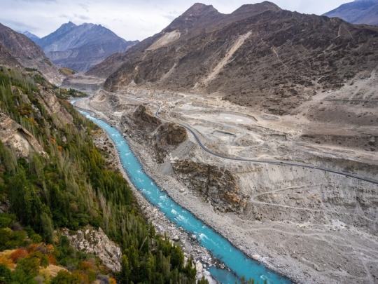
Attabad lake
A lake that doesn’t look real… Even when you’re standing right in front of it. Attabad was born out of tragedy when a massive landslide occurred in 2010. The flow of the Hunza River was blocked, and the now-famous lake was created in its wake. Its bright-blue turquoise waters make the it one of the most beautiful places in Pakistan.
3. Yarkhun Valley
Though it’s relatively unheard of and forgotten compared to Pakistan’s most famous tourist spots, I think Yarkhun Valley was the most beautiful place I visited in the country. Located in the Upper Chitral district of Khyber Pakhtunkhwa, Yarkhun dazzles with its mountain ranges and untouched villages.
Reaching the valley, which stretches for many kilometres past the administrative town of Mastuj, requires a bit of effort if you don’t have your own vehicle. If you do have one though, the ride isn’t too bad – just prepare for mostly dirt roads!
4. Phander lake
Phander Lake, located in Phander Village, is almost too good to be true. The teal-coloured lake sits silently amongst light-green trees befitting a landscape painting.
Despite being insanely beautiful, Phander Lake doesn’t see anywhere as close to the number of tourists as the more popular Attabad Lake does.
5. Khalash valley
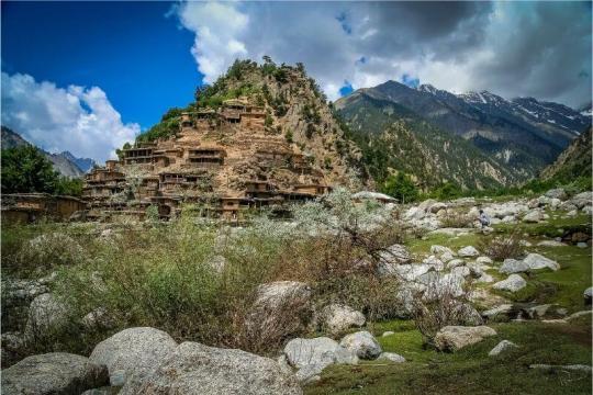
The Kalash Valleys, comprised of Bumboret, Rumbur, and Birir, are home to the Kalash people, a religious and ethnic minority in Pakistan with their own beliefs, culture and language. The valleys they live in are certainly some of the most beautiful places in Pakistan – not just for their natural splendour, but also for the beauty of the Kalash themselves.
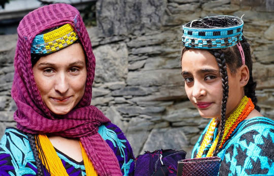
The valley of Rumbur is particularly stunning. Here, kilometres of dusty road and mountains rumble alongside the Kalash River. The Kalash people live in wooden homes that cling to the high hills, and the women are particularly famous for their brightly-coloured traditional dress and headwear that differs from anything else one can find in Pakistan.
2 notes
·
View notes
Text
norse deities + norwegian fjords + theological demons + tolkienesque forenames
Adfjord Adfjorden Adros Agasyvdsen Agfjoriarap Aithir Alaalm Alatn Albel Aldanoch Alion Aloceleirm Amango Amirsen Amius Amlocel Anabouldord Anargunn Andick Andrapard Anfaus Anfjord Angbothiras Anjör Anornstohta Anthulfjord Anthôr Antirgolcar Anárin Arangsfjord Aravaih Archorden Arvörden Asfjor Asfjorden Asméagloka Assan Astomir Astri Audil Auhend Aurangwala Auren Auruf Avine Baacil Bador Badyahráin Bakhîm Bakkudfjord Balachorn Balhu Bassfjord Bathrana Batáron Befjorden Belas Belwë Beraithord Berden Berfin Berfjorden Beriën Berðr Bhūtarih Bifrethuord Binarthil Bolfis Bollves Bombel Borden Borotha Botfjord Braiwen Branger Bregondor Breylas Brynhilm Bukob Bukorden Byzou Bëord Bëorden Bøksh Bømlilzôn Caalas Caapulfjord Caitë Calsfjoros Caláf Carmet Carundil Celbeli Cemna Ceriontir Chadon Charo Chaur Chorden Cifung Cimord Crigyn Custif Dacil Daimo Daingsfjorn Danossion Darata Davrans Digrór Durgord Dwain Dáinleg Déaglandril Déagond Eirden Ekall Ekaðgul Eleir Elemnamir Elfjortdan Elimijden Ellord Ellurath Elordeórwen Elsfjor Elwath Elyssil Elzôr Emunúmeli Ennel Eordariën Eordenden Erfin Ergfjord Ergon Erundurin Eäregangeir Eöldveg Eöndis Falli Fannafjor Ferila Fingsfjor Finnonden Flasto Flaugloful Foceoss Forden Fotarahab Fredhel Fregor Frelegonden Freth Frodir Fréagaphus Frønfjord Fuglasyvden Fulchil Fulefjorden Fulmon Fundil Fættar Fættoldë Fëanwë Fíris Gafjord Galac Galtha Gaminzu Gamne Garden Gerannanhir Gerja Gerún Gilmorch Gladûnam Glofjorden Glombrand Glorden Golgen Golorden Gorden Gordilm Grandog Griant Gundalhul Gungrin Gwatavros Göndis Haamton Habiannyë Haboth Hagoth Hamil Harbaken Harcur Harvegg Hasmain Haudigord Hedhrata Hegiesfjord Helasvielas Heltel Henefjorden Heremo Herfjorin Hersa Hervil Herðr Heush Hirgorna Hirmath Hisula Hjöfn Hlasundord Hlínimilmir Hrasmang Hráðgunnat Hundig Husion Hyargeldir Hyllasvith Høgsfjord Høyfjorden Ifren Imbradir Indil Indord Ingel Inimen Insfjord Ipoch Istar Jaleidanhir Jørger Kabadfjord Kabelzôn Kabli Keelvel Kindherðr Kokilmod Konord Kviden Kvænfjorden Kåfjorbatar Kílis Laghorden Lassa Lasyatopham Laðgunnarna Lefjord Legien Lenetlegos Lesth Lethéoden Lindrinel Linzuzu Lobeyjal Local Luchar Lurfjordene Lyolë Lyssiggin Lóinyang Madin Magorden Mahöðr Maimaberif Maldwaiwen Malmë Marat Mardevith Matáril Mavör Maymo Mefjory Meirson Melech Mephiusoyon Merden Mermala Meron Mindord Mirias Mirion Mirymon Moddon Modwar Mofjor Mofjord Mognara Muzgafjorod Mánair Mánim Mírden Mírias Mírijpfjord Nafjord Nafjormtos Nahöðr Nakkufindis Natanngeir Nieletn Niess Nigrilin Nilas Nimavfjor Noselm Náingfjor Nárabi Ofjor Oherielveið Ohirmo Omalaih Onuinnvand Orden Ordenden Ordennr Orgen Orundul Osanar Paiksord Palaug Palmil Paramanhir Pazôr Pelembou Pelen Peleth Pereir Perichenard Perus Pherelil Phistar Ponthordir Priondil Prottohier Rahir Raudfjord Roden Rondangdus Rondilmaym Rongerait Rumbur Runna Rífarca Rímar Rúmin Safjord Safjorden Sagion Sakercur Sakillebra Salth Samalmë Santan Scasundil Sethilin Sheit Sherosak Sigritston Sjord Sjörþrien Skjes Skjorden Skuflasmog Skuftheld Skögnfange Sniassfjord Snion Soldar Soyontur Stjun Strin Sundregalil Sungeranámo Suromine Sviefjor Syngfjor Tadûn Tafjor Tafjord Tardeór Tariontië Telemir Terstir Thaviðun Thilr Thorden Thordend Théowfalap Tindir Tohis Tohtaras Trethomefa Trophanuir Turana Tysfjord Tyssan Túriefjorda Ugadiladûn Uglil Ulfjord Ullac Ulsfjor Vacrië Vaihel Valenti Valfjorden Valthôr Vandfjorden Vandin Vannamir Vanta Vathormang Vegolak Veiduil Veinas Veldag Vergeir Viefjorick Válimord Válin Vánielragal Værfjorden Waling Walsefjord Woodfjord Xezbel Yeteragon Ytredinglal Zilakeldë Zimron Åkrast Årdennel Éodwine Éotho Írian Økfjorden Økson Þrimerfin Þriondanwë Þögue
0 notes
Photo
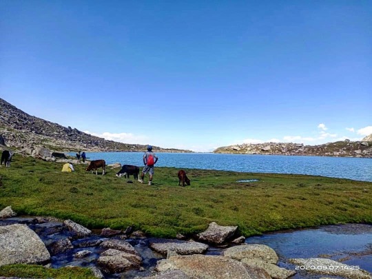
Welcome back ShabDaraz!❤ Back from Bahuk Lake (5300 meter) Rumbur,Chitral. . . . . . . . . . . . . . . . . . . . . . . . #adventure #travel #nature #explore #photography #wanderlust #travelphotography #hiking #mountains #travelgram #chitral #outdoors #photooftheday #instagood #landscape #hindukush #instatravel #naturephotography #history #vacation #camping #traveling #north #picoftheday #beautiful #Bahuklake #adventuretime #travelblogger #trekking #kalasha (at Kalasha Valleys) https://www.instagram.com/p/CE-250NpVUX/?igshid=bkd0ba3b5x9b
#adventure#travel#nature#explore#photography#wanderlust#travelphotography#hiking#mountains#travelgram#chitral#outdoors#photooftheday#instagood#landscape#hindukush#instatravel#naturephotography#history#vacation#camping#traveling#north#picoftheday#beautiful#bahuklake#adventuretime#travelblogger#trekking#kalasha
1 note
·
View note
Text
Pakistan Kalash valley Rumbur Uchao-o Utchal festival
2 notes
·
View notes
Video
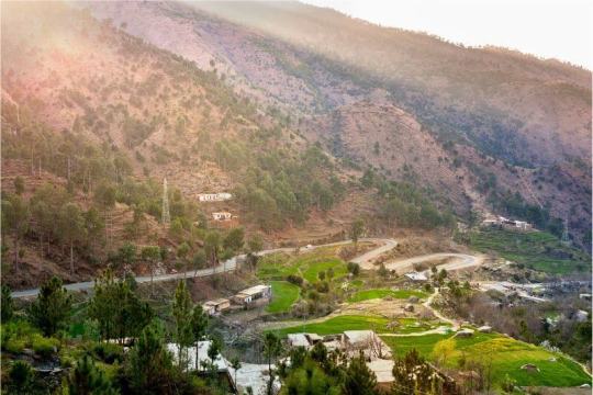
Rumbur Valley, Pakistan
#Pakistan#Kalash Valley#Rumbur#landscape#Central Asia#Hindukush#Kafiristan#Nuristan#Kalasha#North-West Frontier Province
29 notes
·
View notes
Text
Kalash Valley, Khyber Pakhtunkhwa: Travel to the beauties of Pakistan
Kalash Valley, Khyber Pakhtunkhwa: Travel to the beauties of Pakistan
If you want to travel to the beauties of Pakistan Dawnfacts.com provided you Pakistan Travel Guide. This site contains information & guide to every city of Pakistan.
Kalash Valley, Khyber Pakhtunkhwa Kalash Valley
Also see: Mushkpuri, Khyber Pakhtunkhwa: Travel to the beauties of Pakistan
Kalash Valley is situated in District Chitral of province Khyber Pakhtunkhwa, Pakistan. Three valleys are…
View On WordPress
0 notes
Photo
Rinconpandora the Pakistan series: The Kalash of Rumbur, an ethnic group of northwestern Pakistan (Khyber Pakhtunkhwa) #pakistan #pakistani #khyberpakhtunkhwa #kalash #kalashlife #indigenous #indigenouspeople #indigenouspeoplesday #chitral #rumbur #aid #technicalassistance #oda #cooperation #aidassistance #italy #italiancooperation #italianaid #cooperazione #cooperazioneinternazionale #cooperazioneallosviluppo #ethnology #anthropology #culture #heritage #culturalheritage (presso Rumbur)
#indigenouspeoplesday#indigenous#oda#chitral#khyberpakhtunkhwa#rumbur#cooperation#cooperazione#indigenouspeople#culture#anthropology#pakistan#cooperazioneallosviluppo#kalash#culturalheritage#italiancooperation#ethnology#aidassistance#cooperazioneinternazionale#technicalassistance#kalashlife#aid#heritage#italianaid#pakistani#italy
0 notes
Text
New Post has been published on Trekking in Pakistan
New Post has been published on http://bit.ly/2xU7ifI
Other Treks in Chitral

The Following treks are all in an open zone, except where noted.
KALASHA VALLEYS
See Permits and Regulations in the Kalasha Valleys section (p) for a discussion about Zones.
Urghuch
An easy one- day trek goes from Rumbur Valley to Urghuch village in the Chitral Valley 6.5Km south of Chitral town (see map,). From Rumbur, head east up the side Valley south of Balanguru. Follow the true right bank for half a Kilometre, then cross to the true left bank. Three quarters of a Kilometre beyond the crossing, as the trail enters the higher forest, turn south, then contour east and cross the ridge south of Sunwat (3066m). The route heads north- east and half a Kilometre below the ridge lies an abandoned rest house of the Mehtar of Chitral. From here, the trail descends north 1.5Km to a spring (2272m) and the Urghuch Valley. Follow it 2.5Km east to Urghuch village. Find a jeep in Urghuch, walk to Chitral or Ayun, or cross the footbridge over the Chitral River and wait along the Chitral- Drosh road for a ride.
Uchusht
Another route from Rumbur Valley towards Chitral goes to Uchusht, Just 1.5km south of Chitral town, in two easy days (see map,). Take a local guide from Balanguru as the trail is seldom- used and can be tricky. From Balanguru, walk west along the road upvalley for 30 minutes. Head north- east up the true left (east) bank of the second side valley above Balanguru; the first side valley leads to Sundargah. Some 1.5Km up the side valley, cross a side stream to reach the herders’ hut at Palario. Then work steeply east 2Km to the forested ridge top separating Rumbur from Urghuch. Turn north and contour the upper Urghuch Gol. You can camp in this upper basin where water is available. Water isn’t found on the ridge top- only views. Ascend to the ridge between Urghuch Gol and Uchusht Gol, 750m south and east of the high point Urghuch Gol (3510m). Follow the ridge east into forest (3025m) then descend north- east past herders’ huts. Follow the small stream’s true left bank, then the spur north of this stream down to Uchusht village.
Bohok Pass
An enjoyable, moderate three- day loop from Rumbur follows the Gangalwat Gol west past Shekhanandeh. The trail along the river’s true left bank passes through several small settlements to the confluence with the Shekhan Bohok Gol (3518m), 12Km from Shekhanandeh. Head south up the Shekhan Bohok Gol, where the Bohok Pass (4725m) leads into the Kalasha Bohok Gol, which is the valley north of Acholgah. Descend the Kalasha Bohok Gol past Narajau and the junction with the trail coming from Kundyak An (see Day 2 of the Donson Pass and Kundyak An trek,) to the road along Rumbur Gol.
Utak An
Utak An (4647m) is one of several passes with permanent snowfields linking Begusht Gol, the large valley south of Garam Chashma, with the upper Rumbur Gol. The moderate trek starts 4km up the Begusht Gol at Turi Beshgar village, where the Mohour Gol flows in from the south and east. Head 7km up Mohour Gol to Putrik village, where two streams join. The route to the Utak An follows the stream that leads east. Across the Utak An, on its east side, is Dundeeni Chhat. This lake, in the upper Chitral Gol watershed, is the summer grazing area for Chitral Gol’s markhor. The route Continues south- east along the Utak Gol to Chimirsan Ghari and Shekhanandeh (see Day 2 of the Gokhshal An and Dooni An Trek,).
Jinjeret
Jinjeret Kuh, a western tributary of the Chitral River south of Drosh, is inhabited by converted Kalasha, who became Muslims in the 20th century. They still speak Kalashamun, and live in Kalasha- style homes. Several interesting old Kalasha- style forts, or Kot in Urdu, stand near the valley’s highest village. These forts aren’t found elsewhere and are the subject of current research. Jinjeret Kuh is scenic, and the friendly people welcome foreigners. Kalasha Historic Adventure Tours organizes tours of a restored watchtower; go to the Hindu Kush Heights hotel in Chitral to make a booking.
A visit to Jinjeret makes an easy day trip from Drosh or an overnight trip from Chitral. Chitral- Drosh vans cost; special hires. From Drosh, special hires 7km to Dashmanandeh, or to the road’s end, 5km farther. Alternatively, take a vehicle to the mouth of Jinjeret Kuh, then walk three hours upvalley.
Chitral Gol National Park
Merin
The Merin bungalows sit above the Chitral Gol’s South bank (see map,). Female and young markhor live year- round on the cliffs across the river from Merin. Although Merin is best visited from April to October, in December male markhor come to the booster and mate with the females. The aggressive displays and competition between males are an unforgettable sight. You can visit Merin on a day hike from Chitral or camp in Merin and make this an easy two- day trip. From the booster (2200m), descend 45 minutes to a footbridge over Chitral Gol and then ascend 15 minutes to Merin (1980m), 2.4km from the booster. The climb up the northern hillside back to the booster takes 1½ hours. Mohammad Deen, the former mehtar’s huntsman, lives in Merin and can show you where the markhor are. Bring binoculars. Figs, apples, pears, apricots, and grapes grow near the crumbling mehtar’s bungalow, and a now dilapidated former British officers’ bungalow with fine woodwork. The British 38 M/13 Sheet shows the road and trail to Merin, but not the booster, which is very near where the trail meets the road.
You can visit Kasavir (see p) on an easy 9.2km day hike from Merin. The trail is passable only when the water in Chitral Gol is low, usually between August and October. Follow the route up- stream three hours, fording the river up to 10 times. It takes two hours to retrace your steps to Merin.
Bironshal
The mehtar’s bungalow in Bironshal (3068m) sits in mixed forest and grassland. It’s no longer used, in ruins and the trail is not in good repair. Bironshal is best visited from April to October. The easy 10km route to Bironshal begins from the sealed road past the DC’s office in Chitral town (see map,). It takes six to eight hours to ascend 1600m to Bironshal. This is too far a day hike, so plan on two days. Return via the same route in four to six hours. If you have a local guide, you could return to Chitral town via Merin and the booster.
No trail exits beyond Bironshal except a seldom- used, difficult game- watchers’ route to Kasavir. Herders take goats from Merin to Bironshal over a faint track. Reaching Dooni Gol from Bironshal is very difficult. The cross- country route with Class 2 and Class 3 sections is in bad shape and not recommended.
ARkARI
Arkari is a seldom- visited area surrounded by the Hindu Kush peaks that form the Afghan border on its west side and the massif of Gul Lasht Zom (6657m) and Tirich Mir on its east side. Flowing through the area is the Arkari River, a northern tributary of the Lutkho River. Treks in Arkari are challenging routes for adventurous trekkers and offer good wildlife- watching opportunities. A local guide is essential. Jeeps to Owirdeh (Four hours), at the road’s end in the Arkari Valley, depart from the Damdam Hotel at 10am. Special hires. This area is in a restricted zone, and the DC in Chitral authorizes visits.
Besti An and Lutkho An
Agram Gol and Besti Gol are western tributaries of the Arkari River. Besti An and links these valleys, which form a wildlife sanctuary bordering Afghanistan. Because of the steepness of the south side of Besti An. It’s easier to start from Owirdeh in the Agram Gol and head in a counterclockwise direction to form a three- day near- loop. The demanding trek is possible July to mid-September. Exercise caution in Agram Gol, because Agram An is an uncontrolled pass leading to Afghanistan.
The first day, the trail leads up the true right (south) bank 5km, then crosses a footbridge with Gul Lasht Zom prominent to the north- east. Reach Agramdeh village in a grassy area 4km above the footbridge. After a farther 3km, the valley widens and offers views of crags above glaciers, with scree slopes descending to the valley floor. Cross the Dajal Gol coming from the north, and 6.5km from Agramdeh reach the junction (3200m) of the trail coming from the Agram An. Cross to the main river’s true right (south) bank and, a beyond a grove of willows, reach Nawasin Ghari (3447m) after another 8km, eight to nine hours from Owirdeh.
The second day, continue up Agram Gol’s true right bank as it curves south. The routes to Besti An and Lutkho (sad Qalachi) An divide 8km from Nawasin Ghari. The more difficult Lutkho An, with a steep, long ascent from Agram Gol, crosses to the Siruik Valley, with a difficult descent involving Class 3 rock. Sad Qalachi means’ seven lengths of outstretched arms’ as the final 15m to 20m its south- west side requires traversing a narrow ledge along a 75m cliff and may require fixing ropes for safety.
To continue to Besti an, take the east (left) fork of the stream, alongside a glacier, and ascend 600m to Besti An (4633m). Descend 1200m to Khoin village in the upper Besti Gol in 2.5km, six to seven hours from Nawasin Ghari.
The last day, follow the trail down the Besti Gol 6.5km to Besti village, then 9.5Km more to the confluence with the Arkari Gol and the roadhead, five to six hours from Khoin. . Jeeps occasionally come up Besti Gol as far as Besti village.
Maps depicting these two passes are confusing one pass heads south and west from Agram Gol into the Siruik Valley and on to Lutkho; and the other heads south and east into the Besti Gol. The Zebak (J 42- X) sheet names the first pass Sad Qalachi An. The British Survey of India 1930 edition Afghanistan and NW- Frontier province 1:63, 360 37 P/SE sheet and the editors of the Himalayan Journal, however, call this pass Lutkho An. The second pass, which leads to Besti Gol, is named on the Zebak (J 42- X) sheet as Lutkho An. The British 37 P/SE sheet, as well as the editors of the Himalayan Journal, call this pass Sad Qalachi! The authors prefer to call the pass leading to the Siruik Valley and upper Lutkho the Lutkho An and the pass leading to Besti Gol the Besti An, a name given by Cockerill, who travelled here in 1894.
Gazikistan
Gazikistan (grassy place) is a pleasant camp site between the Lower and Upper Gazikistan glaciers, which descend from Gull Lasht Zom. It makes a good base camp for climbs on the Surrounding peaks. The road up the Arkari Valley goes to Owirdeh, at the Agram Gol’s mouth. From Owirdeh to Gazikistan is a two- day trek. Camp at Yun, a summer village 6.5km from Owirdeh, or at Kurobakh, 14.5km from Owirdeh, at the Nuqsan Valley’s mouth. Gazikistan lies 6.5km beyond Kurobakh.
SHISHI and GOLEN
The steep, rocky passes at the head of Jughor Gol and Roghili Gol are not snow- free until July. They’re best crossed before Late September. The routes over all of these passes are infrequently used (see map,). When exploring them, hire a local herder who knows the way since map references are poor and routes aren’t obvious.
Jughor
Jughor village, at the Jughor Gol’s mouth, is south of, and across the river from, Chitral town. Plan to visit Jughor the day before you start in order to organize any trek. Four demanding passes are towards the valley’s head: two head south to Shishi Gol; and two head east, one to Koghozi Gol and the other to Roghili Gol.
From Jughor, walk upvalley to a hut at Chhato Shal (3048m), where the trail crosses to the true left bank. Go 750m farther to a junction (3161m) of two trails. One trail leads south up the kapashung Gol to the passes to Shishi Gol and the other leads east up the Bungolbahan Gol to the other two passes.
The kapashung Gol route splits father upvalley. Here, the route to the south- east crosses the Domukh An (4380m) to Kalas in Shishi Gol. The route to the south follows the Kapashung Gol’s true right bank for 3Km, along the highest branch, to Kapashung Gree (4318m), which also leads into Shishi Gol.
The route east up Bungolbahan Gol stays on the true left (south) bank and offers two options. First, from the 3161m trail junction, you can proceed 3Km upvalley and cross the river. A very steep 500m climb north brings you to the difficult Koghozi An (4480m) from where a steep descent into the Koghozi Valley leads to Koghozi village on the Chitral- Gilgit road. This is a difficult Class 3 cross-country route.
Second, you can ascend half is a Kilometre farther north- east along the Bungolbahan Gol’s true left bank to Roghili Gree (4638m). It’s then a steep 850m scree descent into the basin of the upper Roghili Gol. The basin is labeled Angarbah on the Chitral (I- 42 F) sheet, but local People don’t recognize this name. Follow the south bank of a stream heading north- east 8km farther to Lut Chhat (3764m), a lake. From a trail junction 500m above the lake, you can head north down Roghili Gol by crossing the stream feeding the lake and contouring along its north bank (see the Roghili Gol Treks,). Alternatively, you can cross the Roghili An.
Roghili An
From Lut Chhat in the Upper Roghili Gol (see the Roghili Gol trek, p144) a route crosses the Roghili An (4496m) to Madaglasht in Shishi Gol. Continue along the north and west shores of Lut Chhat. Go beyond the lake for 500m and the cross the stream to its South bank. Here two routes divide: one to the Roghili An and the other to the more difficult Roghili Gree (see Jughor, above). The demanding route to Roghili An (4496m) turns south- east and Crosses a steep Ridge to Madaglasht in Shishi Gol.
Dok An
Dok An (4420m) links Istor, Golen Gol’s highest village, with the upper Shishi Gol. It takes one day to walk to the upper Dok Gol with its streams, flowery meadows and sheer cliffs typical of Golen.
Istor villagers graze flocks in the pastures at the summer settlement of Warazo Shal. From here, it’s a one- day trek over the moderate. Dok An, which is usually open mid-June to September, to Shishi Gol. Once over Dok An, you can turn north- east into upper Shishi Gol, cross the Lohigal An, descend into Lohigal Gol and loop back to Istor.
TURIKHO
The following are specified and unspecified treks that fall within a restricted zone, but no permit is required. The Dc in Chitral authorizes visits.
Rosh
The moderate four- day trek up the idyllic and infrequently visited Rosh Gol begins in Zundrangram, Tirich Valley’s main village. Saraghrar, one of nine 7000m peaks in the area, towers above the valley’s head. The first day, cross the Tirich Gol and walk 13km up the Rosh Gol to Duru (3600m), Labeled Bachorgaz on the U502 Mastuj (NJ 43- 13) sheet, a lovely camp site with flowers and springs amid birches and willows. Continue the second day up the river’s true left bank 2.5km to the Rosh Gol Glacier’s snout, and then on the true left side of the lateral moraine 5km to The lush ablation valley Kotgaz (4300m). Beyond Kotgaz, enjoy a day hike on the moraine- covered glacier for superb views. The fourth day return to Zundrangram.
Udren
Udren Gol and the Udren Glacier flow from a ring of 7000m peaks, including Udren Zom (7108m), Noshaq and Istor-o- Nal. A moderate four- day trek visits the glacier’s head (see map,). From Shagrom, follow the Tirich Gol 1¼ hours, then cross a footbridge and follow the Udren Gol’s true right bank north past Shang-o- Lasht to a camp site 8km from the Confluence. The second day, continues 3Km to the glacier’s snout and walk 2km along its true right side. Head onto the moraine- covered glacier and traverse it diagonally 5km to its true left margin for views of Istor-o- Nal up the South Udren Glacier. Continue on moraine 6km to the confluence with the smaller North Udren Glacier and camp in the ablation valley (4300m). Retrace steps downvalley to Shagrom in two days.
Saraghrar Base Camp
The Saraghrar massif rises at the Ziwor Gol’s head. A demanding five- day trek leads to the base camp of the successful 1959 Italian expedition. From Zang Lasht in Turikho, walk across the bridge over the Turikho River Burzum village (2400m) at the Ziwor Gol’s narrow mouth. Follow the trail north and west up its true left bank, past the hot springs of Uts, 11.5km to Golung Shal (2800m). On Day 2 continue 12km to the once- cultivate Gram Shal (3400m), crossing the river just before it. Ziwor Gol was once inhabited, but abandoned when the glacier at its head advanced. It has since receded, but the valley hasn’t been resettled. On Day 3, head up the true right bank 3.5km to the Ushko Glacier’s snout (Hurusko Kuh Glacier on the U502 Mastuj (NJ 43- 13) sheet), with the Nirogh Glacier’s snout (Nuroregh Glacier or maps) just to the south. Cross the Ushko Glacier just above its snout to its true right side. Leave the glacier and continue south along the Nirogh Glacier’s true left (west) margin as it heads south and bends west. Cross the Sorlawi Glacier coming from the north-west to reach Saraghrar Base Camp (4200m), at the base of the spur separating the Roma and Sorlawi Glaciers above the Nirogh Glacier. Here you’re surrounded by 6000m and 7000m peaks and get the best view of Saraghrar. Return downvalley to Zang Lasht in two days.
Chikor Pass
Chikor Pass (44330), which is usually open mid-July to mid-September, links Uzhnu and Ziwor, two uninhabited valleys branching west from Turikho Valleys. A moderate five- to seven- day near- loop starts at Uzhnu village along the jeep road in Turikho. Head north and west up the Uzhnu Valley, then turn south- west into Chikor Gol. Climb to the Chikor Pass and descend south- west to Gram Shal in the Ziwor Gol. Go east down Ziwor Gol returning to Zang Lasht in Turikho. This is an unspecified route in a restricted zone.
Nizhdaru An
Nizhdaru An (5087m), an infrequently crossed pass, links Sor Rich in Rich Gol to Bang in the Yarkhun Valley. This demanding 25km technical trek takes two to three days and is best done in July or August. From Sor Rich (2785m) walk up the Chakosh Gol’s true left (south) bank 5Km to Ghari Chhan. Continue another 8Km and camp below a small glacier descending from the pass. The next day, ascend the glacier steeply to the Nizhdaru An, which may require fixing rope or cutting steps; bring an ice axe and crampons. Descend steeply over scree on the west side to the meadows of Garagar (4023m). Camp here or continue to Bang in a long day. Bang- Mastuj jeeps. Special hires.
Hindu Raj Crest
A demanding and exciting five- day cross- country trek traverses the crest of the Hindu Raj Range, crossing three seldom- visited passes. Anyone attempting this route needs to be an experienced trekker, accomplished at route- finding, completely self-reliant and able to communicate with herders in pastures in each separate valley. Khot herders know the Ghochhar An route, Bang herders the Bang Gol Muli An, and Paur herders the Siru An. The passes are typically snow- free between July and late September, but Plan to do the trek before early September when herders depart the pastures.
Walk from Khot Lasht to Shahglasht in 3½ to four hours on Day 1 (see map,). It’s seven to nine hours on Day 2 to reach Garagar. From Shahglasht, leave the trail to Khot An and continue to the Jharogh huts, along the Jacha Gol’s true left bank. Cross to its true right bank and continue up stream. The Jacha Gol (not marked on maps) and the Ghochhar Gol meet just beyond. Continue along the Ghochhar Gol’s true right (west) bank 1.5km to the confluence with the Mazan Gol. Follow the Ghochhar Gol, and after passing beneath several small Permanent snowfields, cross the stream to its true left bank and ascend to the Ghochhar An (4727m), involving a steep scree ascent, and descend over a small glacier. Continue to Garagar, a herders’ settlement in upper Bang Gol.
On Day 3, head north- east, cross Bang Gol Muli An (4763m) and descend, traversing a Small glacier, to the upper Paul Gol herders’ settlement at Pimin Sor in five to eight hours. On Day 4, head north, then north- east to cross Siru An (4572m). Camp in the upper Siru Gol Beyond the Siru glacier, five to seven hours from Pimin Sor. On Day 5, continue down the herders’ trail along the Siru Gol’s true right bank to the confluence with the Ishperu Dok Gol. Cross a footbridge to the Ishperu Dok Gol’s true left bank and follow the trail to Yashkist at the confluence with the Yarkhun River.
BASHQAR
Glacial lakes dot the upper Bashqar Gol, above which towers Ghuchhar Sar (6249m). Beyond the first lake, the valley divides: Thalo Gol heads south- west and Manali Gol heads south- south east. These upper valleys offer interesting, demanding, trekking and climbing possibilities, and are best visited by starting/ finishing in Sor Laspur. It’s ill- advised to attempt the difficult passes at the head of these valleys, which leads to lawless areas where people are armed, may not welcome trekkers, and should be considered dangerous.
It’s tedious going up the long, rocky Thalo Gol, which has numerous hanging glaciers. The moraine of the Thalo Glacier descends to the valley floor and another glacial lake lies beyond the Thalo Glacier. Thalo An leads to Dir’s Panjkora Valley. The way up the shorter Manali Gol leads over the large Manali Glacier, and on to an upper cirque. Manali An leads into Swat’s upper Gabral Valley.
0 notes
Last Seen Blogs

falaihullo
Rock And Roll Buckarooo

yukinikuu
雪yuki

dailyoccult
Daily Occult

ebii-chann-blog
DailyTale

teddybearty
Where Disaster Happens