#mt vesuvius recreation area
Text
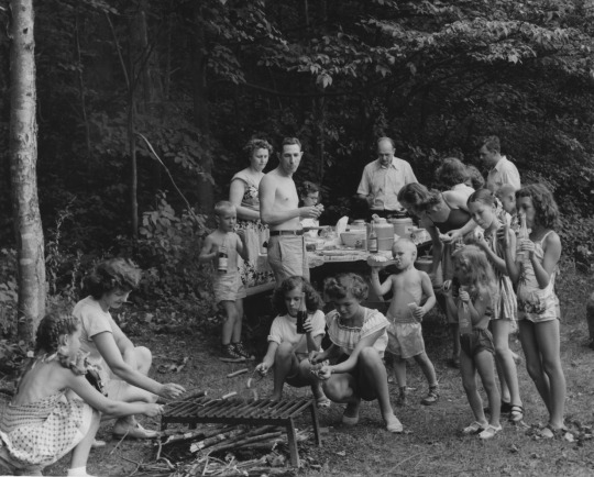
Crushing some hot dogs and sodas at a family picnic at Lake Vesuvius Recreation Area.
Ohio
1952
#vintage camping#campfire light#ohio#camping#history#family#hot dogs#road trips#mt vesuvius recreation area#1950s
104 notes
·
View notes
Photo
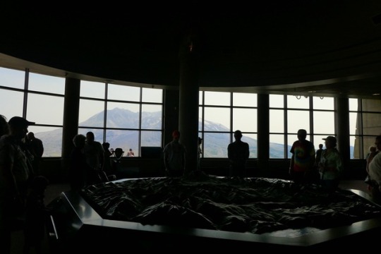


My visit to Mount St. Helens, August 22, 2017
Johnston Ridge Visitor Center | Mount St. Helens north face, runoff from snow cutting through 1980s pumice plain
Close-up: melting snow rising as steamclouds from the still-cooling lava dome of 2004-2008 eruption that’s partly filled 1980 crater
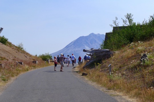
Blown-down trees on surrounding hills show direction of blast | Spirit Lake in distance (human figures on trail for scale) | More blowdown trees in background
Blowdown tree, possibly flew 5 miles from Mount St. Helens, with “Indian paintbrush” flowers and pearly everylasting
Bees in fireweed | Bees in pearly everlasting
Johnston Ridge Memorial to those who died
Let me tell you a story.
When I was a little girl, there was a beautiful mountain.
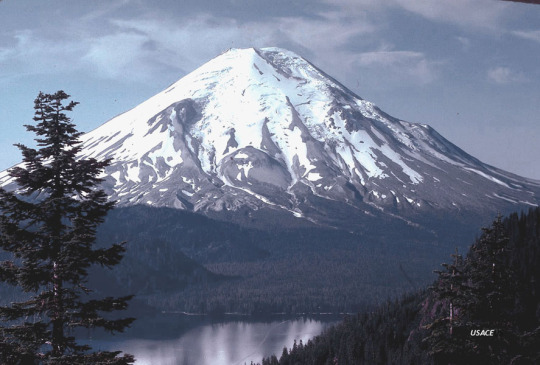
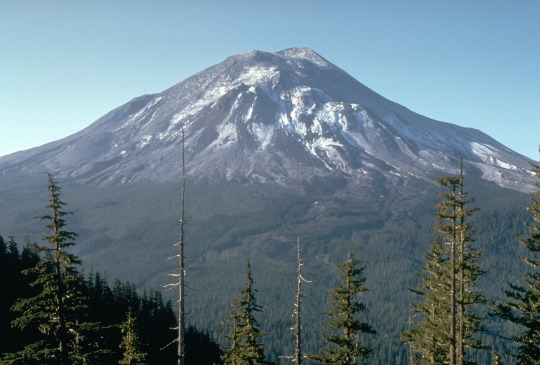
Mount St. Helens behind Spirit Lake: U.S. Army Core of Engineers, 1978
The explorer George Vancouver had named her after some British diplomat. But native peoples called her Louwala-Clough, “smoking mountain,” or Loowitlatkla, “Lady of Fire,” or just Loowit.
(cont’d with more photos below)
Loowit taught people fire; she guarded the Bridge of the Gods. She had been an old woman, but the Great Spirit transformed her into a beautiful maiden for her good deeds. Then two brothers, Pahto and Wyeast, fought over her, throwing flaming rocks and laying waste to whole forests. At last the Great Spirit turned all three of them into the mountains westerners call Mount St. Helens, Mt. Adams and Mt. Hood.
Native peoples of the Pacific Northwest knew volcanoes were shapechangers. Geologists knew. But by 1980, most people living nearby were barely aware of the sleeping giants looming over them. They didn’t realize just how dramatically they could change.
Most Americans’ notion of a volcano was shaped by TV images of Kilauea spewing red-hot lava. Fluid when it first erupts, lava cools rapidly in open air, so that its leading edge creeps rather than runs. Even I can outwalk it. Like millions of tourists, I’ve safely watched Kilauea’s lava fountains and flows from a few miles away.
youtube
(Sorry, Hollywood. Lava is usually not that scary, unless you’re a house.)
But stratovolcanoes like Krakatoa and Vesuvius are different. Their magma (lava before it erupts) is sticky and stiff. It piles into rugged peaks, clogs their pipes and caps old craters with heavy domes. Stratovolcanoes can sleep for centuries, sometimes thousands of years. When they erupt, they explode.
Large chunks of the old summit get blasted out, some pieces as big as houses.
Frothy, gassy magma flies out as blobs of pumice: hole-pocked volcanic rock that isn’t very dense but can bury a town (see: Pompeii).
Powerful explosions pulverize magma into volcanic ash, which is actually tiny jagged grains of glass. Fine ash can fill lungs, scratch eyes, clog machinery, or fuse into a glass coating if sucked into a jet engine.
Water seeping into hot rocks may flash to steam. Steam explosions are dangerous because there’s no warning.
Glaciers and snow and rivers mix with ash to form mudflows the consistency of wet concrete, able to flow as fast as water. Geologists use the Indonesian name for them, lahars. Some lahars are boiling hot.
Scariest of all are pyroclastic flows, hurricane-force avalanches of superheated ash, pumice, boulders, semi-molten rock, and hot gasses (including sulfuric acid), about 1000°C (nearly 2000°F). They travel at speeds up to 700kph (450mph). They flow over ridges and hills, and can even cross water on a cushion of steam, as the islands closest to Krakatau learned the hard way.
Here’s lahars (Japan has remote cameras to watch for them):
youtube
Pyroclastic flow in Indonesia (truly terrifying):
youtube
That was what geologists were worried about, when Mount St. Helens stirred to life with a flurry of moderate earthquakes on March 19, 1980.
Trouble is, geologists didn’t yet have many active stratovolcanoes under their belt. They could reconstruct what St. Helens was capable of from the remains of ancient eruptions, but what would she do this time? More importantly, when?
Drawing on experience from Kilauea, United States Geological Survey scientists planted instruments around St. Helens to monitor her vital signs. They measured thousands of moderate-sized earthquakes with seismometers. They installed tiltmeters on her flanks to monitor the groundswell as magma rose underneath. (With one bizarre exception, there was no movement.) They measured escaping gasses, since other volcanoes’ SO2 emissions spiked before erupting. (Hers didn’t). They scanned with infrared cameras, searching for major heat sources near the surface (not much).
A week after the first earthquake swarm began, St. Helens cleared her throat and opened a small summit crater, belching steam and ash that dirtied her snow. Spirit Lake near her feet was evacuated, and local officials set up roadblocks around a no-entry zone.
Same view as my photos. Note “bulge” in front of original summit, 1 day before eruption. Harry Glicken, USGS. (Also notice 150-200 foot fir trees on slopes.)
Loowit was living up to her “smoking mountain” name. Local vendors made a brisk trade in t-shirts and souvenirs. But after a few weeks, media and public interest began to wane.
Weyerhaeuser logging, the main employer and property owner in the region, couldn’t let a few earthquakes get in the way of million-dollar profits, not when the logging season was so short. Nor was the state’s fishing and game department happy about the closure of popular lakes and recreation areas. Their main source of income was permits, and it was the start of the hunting and fishing season.
So Governor Dixy Lee Ray shrank the boundaries of the “Red Zone,” the mandatory evacuation area that USGS scientists had advised. She drew in the exclusion zone to just three miles from the summit on the northwest side, along the Weyerhaeuser property line. Hundreds of miles of logging roads now offered public access outside the roadblocks.
Geologists warned about pyroclastic flow and mudflow, but most people still imagined lava like Hawaii’s. Besides, the geologists couldn’t tell when or even if these things would happen. All they knew was that St. Helens had done it before.
Except this time, she was doing something new:
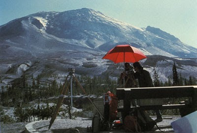
“Bulge” from the side a few days before eruption, photo by Peter Lipman.
That bulge distorting Forsythe Glacier was swelling 3-4 feet towards the north each day, an unheard-of ground movement. Geologists guessed it would come down in an avalanche/landslide that could reach as far as Spirit Lake. Dr. David Johnston was one of the most outspoken on the danger, communicating eloquently to state officials and news media.
But the earthquakes and ash explosions had died down. Residents of Spirit Lake kicked up a fuss, and were grudgingly given permission to retrieve belongings from their cabins on Saturday, May 17. They were planning to return Sunday.
At 8:31 Sunday morning, David Johnston was on duty at the monitoring post the USGS had established on Coldwater Ridge, five miles north of the mountain. (Above, photo of David from the day before, snapped by a colleague saying goodbye).
At 8:32, one more earthquake, not much bigger than those before, was the straw that broke the camel’s back. It triggered the biggest landslide in human history (frames 1-4):

[Animation stitched together from still photos by Gary Rosenquist, 11 miles NE]
Ham radio operators heard David Johnston’s last words as he shouted a warning: Vancouver! Vancouver! This is it!
Within minutes, Mount St. Helens was 1300 feet shorter, with a huge crater over a mile across cutting deeply into its north face. The landslide ran out seventeen miles.
Another view, AP, from The Atlantic’s St. Helens photo gallery.
That landslide had popped the cork. An explosion more powerful than an atom bomb blasted out: an absolutely colossal pyroclastic flow. Every living thing on and near the mountain was blown away or incinerated, topsoil scoured right down to bedrock. No one ever found a trace of Johnston’s trailer. Beyond the zone of total destruction, trees up to 10 feet across were blown down pointing away from the mountain for dozens of square miles. Beyond the blowdown zone, standing trees were stripped and scorched.
Lakes were dashed out of their basins and sloshed back in miniature tsunamis, dragging debris down with them. Spirit Lake’s bed was raised 100 feet by landslide fill. More pyroclastic surges followed, devastating over 200 square miles of forest. Charred branches, needles and cones fell on awestruck climbers on Mt Adams and Mt Hood, watching from 30 and 60 miles away.
That was how geologists learned that, every now and then, volcanoes don’t blow up. They blow sideways.
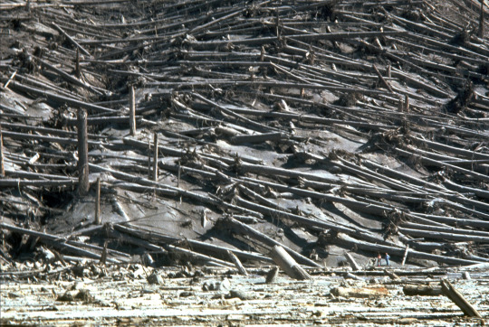
USGS photo of blowdown zone (see scientists at lower right for scale).
St. Helens did it all: lahars that flooded river valleys and bulldozed houses and bridges, ash fall, pumice fall, mudball fall, and more. Immense clouds of ash caused white-out (or rather, black-out) conditions, blanketing and shutting down most of Washington State for days. The Columbia River’s shipping channel had to be closed for dredging after its 40-foot depth was filled in to 17 feet. Intermittent eruptions continued for months.
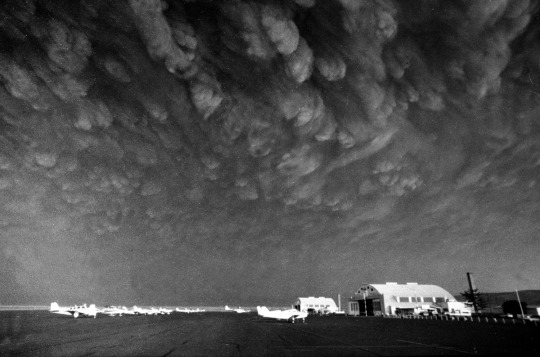
Ash cloud reaches Ephrata airport, Washington. Mike Cash/AP.
In her press conference, Governor Dixy Lee Ray said that those killed in the eruption had deliberately bypassed roadblocks and violated the “Red Zone.” President Jimmy Carter took her at her word and repeated the claim. That’s the story I remember from The Big Blast, a Scholastic book about the eruption that came out later that year.
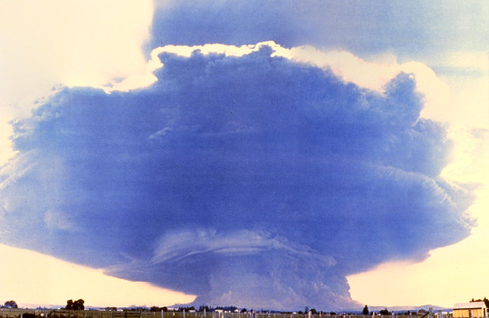
Eruption seen from Toledo, WA, taken by Rocky Kolberg
In fact, only four of the 57 victims were inside the “Red Zone”, and three had permission: USGS official David Johnston and two scientists staying at Spirit Lake for field research. The only person who had defied evacuation orders was an old codger, Harry Truman (no relation of the president), who refused to leave his lakeside lodge. Governor Ray had sent him a letter congratulating him on sticking to his principles.
Unsigned on the governor’s desk lay a proposal for a revised hazard map devised by sheriffs and geologists in consultation with Weyerhaeuser, moving the restricted zone’s boundaries back out by several miles.
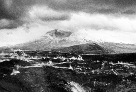
Day after eruption; vast pumice plain still steaming with melting fragments of the mountain’s glacier embedded in debris. AP.
Mount St. Helens was made an official national monument. It’s become an enormous laboratory for geologists to study deposits left by a well-documented eruption, and for biologists to study how life recolonizes an area sterilized by a catastrophe.
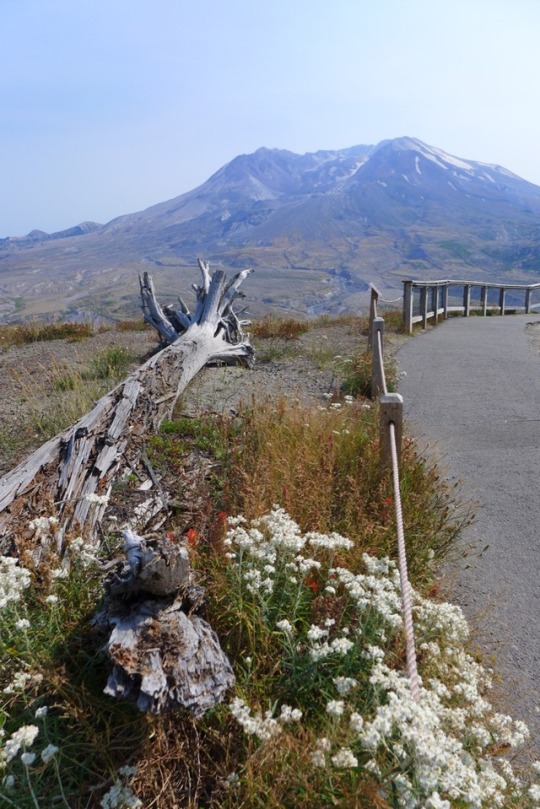
(My photo, Aug 22, 2017, Toppled stump embedded in slope; Johnston Ridge Visitor Center behind.)
A visitor center was built on barren Coldwater Ridge, renamed Johnston Ridge. There, 37 years later, I stood listening to a ranger who wasn’t born in 1980, telling tourists about mountain goats and hummingbirds returning to the crater. I watched bees buzzing among a profusion of flowers, ground squirrels chasing each other in burrows under the stumps of dead giants, fir saplings growing where a 200-foot-tall mature forest once stood.
Sightseers posed for selfies in front of Loowit, still lovely even with her scars. They gazed out at the spectacular, alien landscape, softened now by greenery creeping back. It’s a miraculous transformation, considering the bleak moonscape of just a dozen or so years ago.
The visitor center doesn’t dwell on those who died. Far better to focus on creation than destruction.

(My photo, Aug 22, 2017. Flowers on Johnston Ridge)
But some stories you learn as a child stay with you.
So while I spent three hours exploring a flower-tufted ridge below that massive, strangely beautiful mountain, I also paid my respects to 57 names carved in stone, many of whose stories I know. I brushed fingers against the name of David A. Johnston. I looked out at that huge scooped-out crater on the mountainside and whispered, Vancouver, Vancouver, this is it!
39 notes
·
View notes
Last Seen Blogs

dispense-blog1
autoplay.

hellhue
VINDICATED

jessiejrose
Pretty princess in the making


hikabarin
Hikabarin