#Treepedia
Text
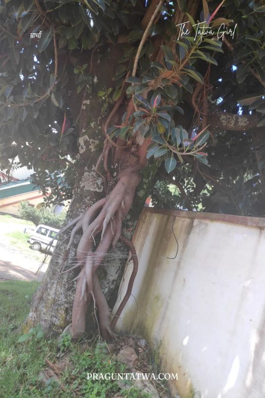
Tree Love February 2024
Life of a Rubber tree
Start harvesting at 7th year
Produces Latex for 25 years.
Used for furniture at retirement
I have been fascinated by Rubber trees since my childhood. They are the first Love in the Tree Love series.
Firstly, because of the shiny green leaves it bears.
Secondly, because of the by-product this tree provides.
Thirdly I have seen the rubber tree plantation with my own eyes…
View On WordPress
#Plant more trees#ThursdayTreeLove#Heritage Trees of India#Thursday treelove#Tree Clicks#Treectionary#TreeLove#Treepedia#Trees#Trees Are Life#Trees Around Us
0 notes
Text
TREEPEDIA (MIT) : SMART CITIES, MONITORING AND WELLBEING
combiner données, qualité de vie, et villes intelligentes
Extrait de treepedia, ville de Bréda, 2022
Temps de lecture : 3 minutes,mots-clés : SmartCities, monitoring, données, datas, villes, Cities, publics spaces, management, gouvernance, greenery, espaces verts.
Chers lecteurs,
Lorsque je présente les enjeux des smart Cities lors de conférences ou autres présentations aux développeurs immobiliers ou pouvoirs publics, il est souvent compliqué de…

View On WordPress
#cities#datas#données#espaces verts#gouvernance#greenery#management#monitoring#publics spaces#smartcities#villes
0 notes
Photo


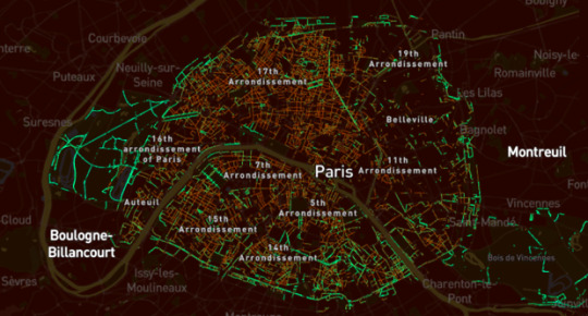
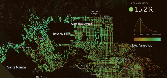
GREENING THE CITY: Street trees have a multitude of environmental and social benefits, begging the question of which cities have the greenest streets. As reported by Fergus O’Sullivan in CityLab (4 January 2017), MIT’s Senseable City Lab is pushing toward an answer to this question with a new project called Treepedia.
A map website that catalogues the density of the tree canopy in 10 global cities, Treepedia uses information from Google Street View to create what it calls the Green View Index—a rating that quantifies how green a street view looks according to the number of trees it contains.
Rating a huge number of street corners for the relative greenery of their appearance, Treepedia also allows browsers to click on a series of dots that reveal street view images of the location in question. The result is one of the most detailed catalogs of urban greenery available.
For anyone who loves to explore the texture of cities, the maps are certainly an engaging browse—and that engagement is the point. The project’s overarching goal is to make issues of urban and environmental planning (and the data that underpins them) more accessible for non- or semi- professionals.
See the full story in CityLab (4 January 2017),
28 notes
·
View notes
Photo

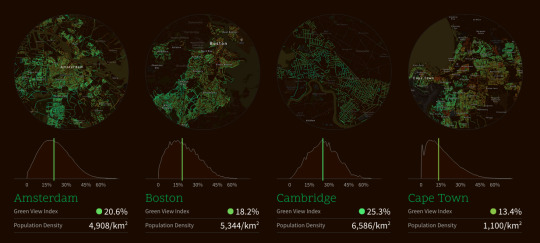
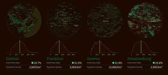
Ciudades con mayor cobertura de árboles en el mundo 🌲🌳🗺️
1- SINGAPUR 🇸🇬
2- SYDNEY 🇦🇺
3- VANCOUVER 🇨🇦
4- CAMBRIDGE, MA 🇺🇸
5- DURBAN 🇿🇦
6- JOHANNESBURGO 🇿🇦
7- SACRAMENTO, CA 🇺🇸
8- FRANKFURT 🇩🇪
9- GINEBRA 🇨🇭
10- AMSTERDAM 🇳🇱
Fuente: Treepedia (MIT/WEF)
6 notes
·
View notes
Quote
Treepedia.
Exploring the Green Canopy in cities around the world.
http://senseable.mit.edu/treepedia
Senseable Lab del MIT con el Foro Económico Mundial (WEF) crean Treepedia.
http://www.forbes.es/actualizacion/8263/las-ciudades-mas-verdes-del-mundo
Las ciudades más verdes del mundo.
Forbes.es
0 notes
Photo

Treepedia
Kobe, Miami, Oslo and Quito are some of the new cities explored by #Treepedia, our ongoing project mapping street by street the tree canopy mitigating air pollution in world metropolises.
It’s not about which city is greener, it’s about raising awareness on how understanding and promoting urban tree cover has never been more important.
Source: MIT Senseable City Lab

4 notes
·
View notes
Text
LA CITTÀ CON PIÙ ALBERI D’ITALIA
La presenza di vegetazione nelle città è un elemento di qualità della vita e di attenzione per l’ambiente che fa parte della cultura di una comunità e che si conquista e si protegge nel tempo.
ll MIT di Boston, una delle più prestigiose università del mondo, ha sviluppato un algoritmo in collaborazione con Google che calcola “l'indice di verde visibile” nelle metropoli internazionali, individuando le 17 città più verdi del mondo. Torino è risultata l’unica italiana, con un tasso di verde visibile del 16,2%. La più verde in assoluto è Singapore e quella europea è Oslo.
La città di Torino è una delle più ricche di alberi al mondo, grazie ai suoi numerosi parchi e alle aree protette intorno al fiume Po e in collina. Circa 320 Km di viali alberati e 160.000 piante radicate lungo le strade e nei suoi giardini pubblici. La storia degli alberi torinesi ebbe un forte impulso nel 1808 quando il consiglio degli edili ne definì il piano generale ma già nel ’600 le grandi strade di collegamento con le residenze Sabaude erano lunghi rettilinei alberati.
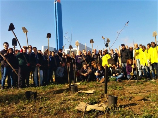
A Torino però la sensibilità ecologista non è solo cosa del passato; la città aumenta costantemente il suo polmone verde. Nel mese di maggio 600 nuovi alberi sono stati piantati e altri 600 sono stati messi a dimora da novembre nello spazio verde nei pressi dell’inceneritore. L’intervento è stato svolto in collaborazione con il gruppo volontario spontaneo Badili Badola Guerrilla Gardening che con pale e zappe e tante persone di buona volontà ha creato una piccola foresta.
Fonte: Treepedia; Badili Badola; Guida Torino - 20 maggio 2018
1 note
·
View note
Text
Tree Love January 2024
“I love walking in the woods, along the trails, by the beaches. I love being part of nature. I love walking alone. It is therapy. One needs to be alone, to recharge one’s batteries.”
~ Grace Kelly
While traveling across Nilgiri forest enroute pykara lake in Ooty, I was memserised by this green spread.
This foliage was picture worthy.
We cannot overemphasize forests’ vital role in life on earth…

View On WordPress
#Plant more trees#TreeHug#Landmark Trees of India#Nilgiri Hills#Tree Clicks#Treectionary#TreeLove#Treepedia#Trees#Trees Are Life#Trees Around Us#Trees of Nilgiris
0 notes
Photo

Treepedia's map of the "Green View Index (GVI)" in Turin [1606x756]
3 notes
·
View notes
Link
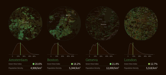
comparing tree density/locations in different parts of the world
1 note
·
View note
Text
Treepedia – MIT Maps and Analyses Tree Coverage in Major Cities
centro de ideas daydec (design) Users can compare their green canopy to cities across the world. Image Courtesy of MIT Senseable City Lab Researchers at the MIT Senseable City Lab have launched a new platform using Google Street View data to measure and compare the green canopies of major cities across the world. Treepedia, created in collaboration with […]
from Treepedia – MIT Maps and Analyses Tree Coverage in Major Cities
0 notes
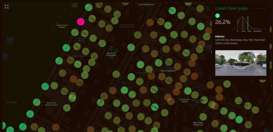
Photo
Mapping urban trees.
Treepedia: interactive map with other cities >>
94 notes
·
View notes
Photo

Treepedia mapping project by MIT will tell you how green is your city
Trees make cities healthier and more livable. They help mitigate extreme temperatures, provide a natural respite from traffic, noise, and congestion, and improve the quality of life for those living in urban environments.
Source: http://ift.tt/2iAAHSm
1 note
·
View note
Last Seen Blogs

kachou-news
お知らせ - 花鳥

nuggles
lovely and very talented

p1n3appl3p3n
my little list of likes
lenguadgato
Lotus

imgpack
Untitled