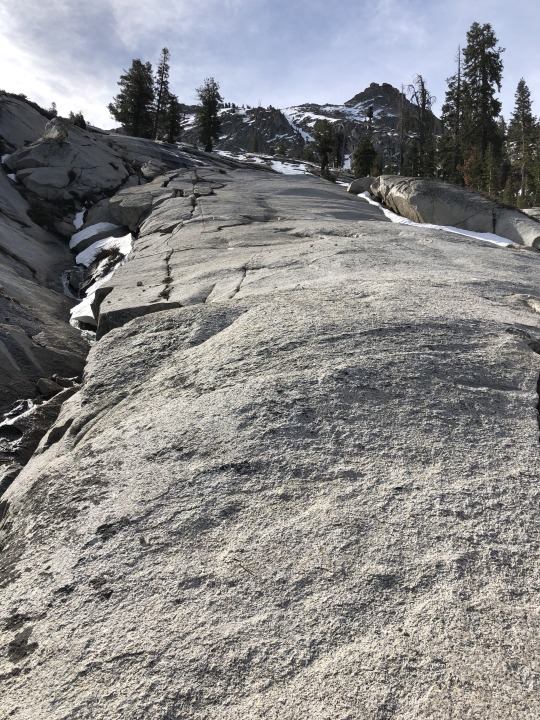
#Moro Campground
Text

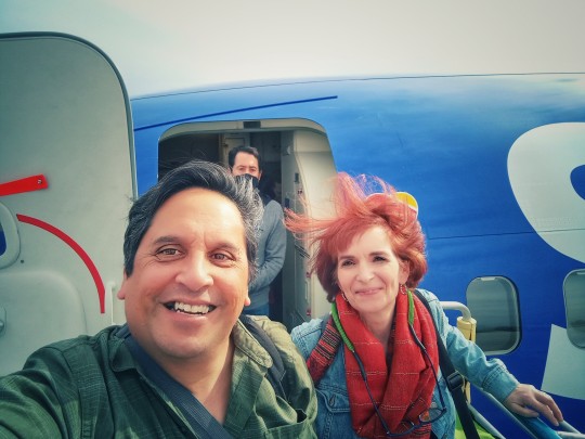
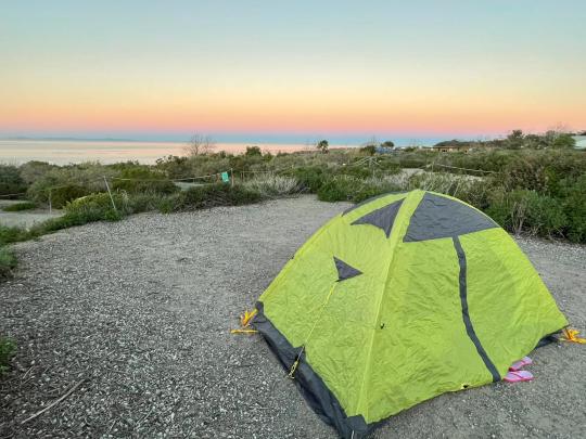
The photo above was taken by our friend Dolly whose idea it was for all of us to scootch our feet close to the fire like this. Our moment around the campfire represents the end of Saturday, our last full day of adventure. The way it started, though, was something completely different from this little moment of community.
So to begin at the beginning...
Yesterday. Was lazy morning day.
Breakfast leftovers for me... and a haircut.
No joke. Kimmer took one look at the shaggy hair dangling down from under my hat over my forehead... and declared it to be hair cutting time.
Did not. See that coming.
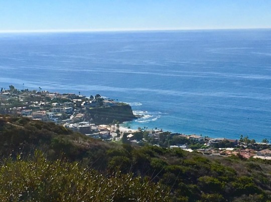
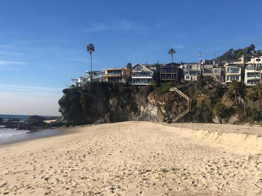
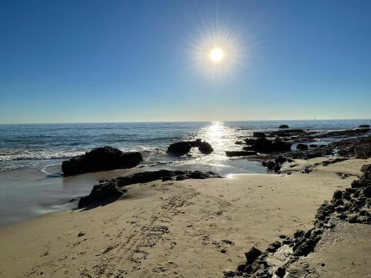
As a result of Friday's travels, we're at Moro Campground now, overlooking Crystal Cove, and we're coming to grips with the fact that we don't have a hookup here so...
No power.
As in got no electricity.
So now there are the logistics of recharging our phones and laptops. Which is funny 'cause technically...
We're camping.
What can I say?
Call it the best of both worlds. 😉
Derek's got a solar panel, though, and it's charging a battery we can all tap.
Only our phones, though.
Because if we wanna charge our laptops, well...
That's gonna involve Starbucks.
Before we get to that, though, let's quickly review lazy morning day in which we take roughly four hours to accomplish what we normally get done in under an hour at home.
Yup.
We're taking everything, every minute of the morning in the slowest way possible because we are in no rush. We're not motivated to hit the gas. We can take our time. And we can choose to be distracted by nothing in particular. Sometimes several nothings.
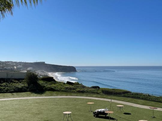
We can take in the scenery. We can fully appreciate the view, the breeze, the sun, the Pacific Ocean, the horizon that travels forever, the sailboats lined up between the horizon and the shore.
And we do. We indulge all that. We allow Time to flow around us until, basically, it's one in the afternoon when, for no particular reason, no agenda to follow, we actually feel inclined to do something.
So finally we drive the mile to that Starbucks at Crystal Cove Shopping Center and camp there, inside, to power up my battery pack, charge up Kimmer's laptop, continue the business planning from the day before that delved into a lot of lessons we learned through professional experience over the years touching on multiple businesses, different leaderships, both good and bad decisions, and both sustainable and unsustainable courses of action.
Around this time, Kimmer also figures out our next day's logistics. I took a crack at it a coupla days earlier to no avail. With her laptop, though, Kimmer hits on something that's largely the reverse of what we've already done... with one addition.
What we're gonna do is... on the morning we leave camp, we're gonna drive straight to the Escape Campervan location in Inglewood to return Big Foot the campervan. After that, we Uber or Lyft to LAX to pick up the rental we'll need for maybe six hours. After that, we'll drive to SNA and check in our four largest bags. Then we drive to Irvine for the afternoon and, at the end of the afternoon, we drive back to SNA, turn in the car. BAM. Done.
By the time we wrap up business planning and travel planning, it's 330 and, after a quick bit of shopping at Trader Joe's, we head back to camp, only then realizing we forgot to pick up the ice we promised Derek.
So back at camp I drop off Kimmer, pick up the boys, and head down the Pacific Coast Highway on our way to Ralph's grocery store to score us some twenty pounds of crushed ice.
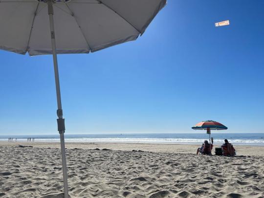
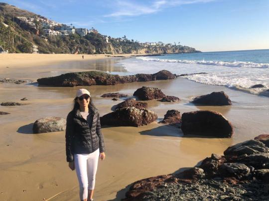
The ride down is chatty, believe it or not, covering reddit, acts of congress, q-anon, and learning hacks when your teacher's not making any sense to you. After the ice, we're back at camp around 430 to join Kimmer on a beach walk that involves a bunch of walking and even more taking of photographs. Because hey. There's a lot of nature down there along the shore, on the beach, and at the base of the cliff.


Five forty-five we're back at camp to keep an eye on Cookie the Chihuahua whilst Derek drives off to pick up close family friends.
Why?
Because we're gonna do another round of celebrating Kyle's upcoming birthday!
Whooohoooo!!!!!
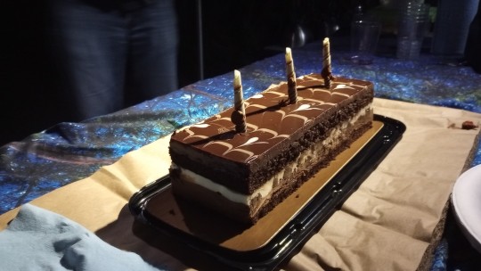
The close family friends, Don & Dolly, arrive around 630 bearing a home cooked pasta dinner, red wine (for the adults), crackers 'n white fish and, of course, CAKE.
Delicious.
Chocolate.
Cake.
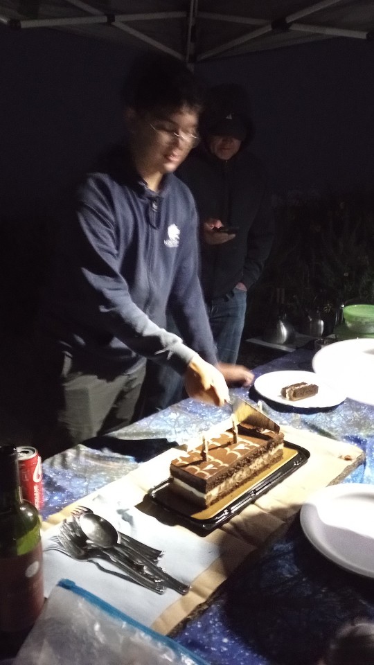
We have a fantastic time as conversations break out all over the place as day turns into evening turns into night. There's some catching up, right off the bat. There's some news of the day. Some topics about which we're individually passionate. And other random stuff progressing straight through dinner all the way to cake which means it's time for all of us to sing the Happy Birthday song followed by the other Happy Birthday song that goes
Happy happy birthday
From all of us to you
We wish it was our birthday
So we could party too
HEY!!!
The song involves thunderous clapping on the beat and a big finish.
So it really can get quite loud. 😁
After that, we all take chairs around the propane-fueled campfire. We're close enough that our feet are almost touching the fire so Dolly tells us to put our feet up close and she snaps a picture.
This one. Right here...
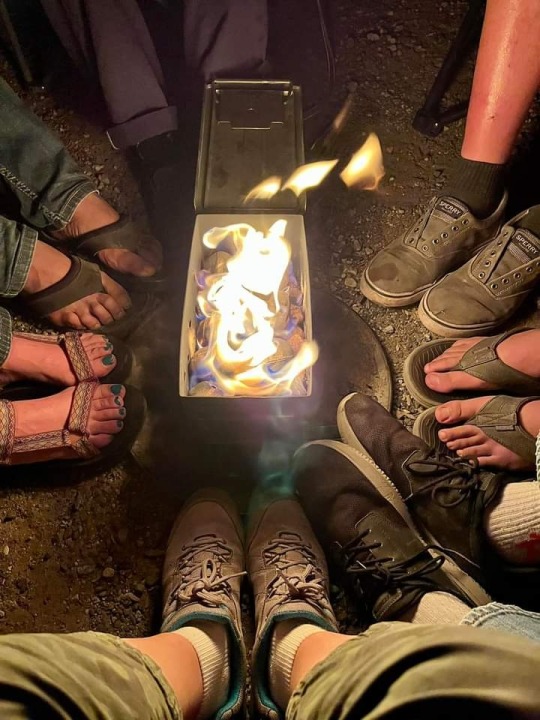
Afterward, I'm struck by the thought that, because it is cold outside tonight, we're all better off being closer to the fire together. We're better off sharing stories and opinions and personal history and just stuff. Random stuff. Family stuff. Health stuff. A little past, a lot of present. Even sometimes about the future.
And it's in this space, this tiny community, with human beings connected to each other through family and friendship, it's in this social space, this relational vibe where our pre-celebration ends, where our Saturday comes to its conclusion: around the campfire with well wishes and fare-thee-wells, and a deep conviction that this experience is good for the soul.
As the night comes to a close, fog continues to roll in from the ocean and I wander over to stand on a perch above the shore where I can see the fog's beginning to wrap around all the campfires along the cliff. In a way, instead of obscuring those fires, the fog serves to highlight, contour each family, each group of friends, huddled around their campfires. It places emphasis around all these little groups. These tiny communities.
And the flames that bring them warmth.
😊
#photographs#photo ops#photo ideas#lazy morning#breakfast leftovers#haircut#moro campground#crystal cove#pacific coast highway#solar panels#starbucks#pacific ocean#crystal cove shopping center#logistics#business planning#travel planning#trader joe’s#beach walk#nature walk#friends#friendship#dinner#birthday cake#wine#crackers#chocolate cake#conversation#socializing#catching up#happy birthday
0 notes
Photo
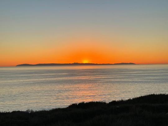
24/34: and on the 24th day I rested... took a “zero” day today. Spent last night at Moro Campgrounds in Crystal Cove for another gear test. I need long johns!!! Woke up to an incredible sunrise but the company was the best part. #PCT2019 #training #hiking #thruhike #getyourhearton (at El Moro Campgrounds (Crystal Cove State Park)) https://www.instagram.com/p/BuPJue9n9S-/?utm_source=ig_tumblr_share&igshid=1olvkq69lggtv
1 note
·
View note
Photo
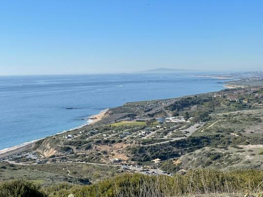
There is nothing like the Pacific Ocean. #travel #travelphotography #traveltheworld #landscapephotography #california #newportbeach #pacificocean #alltrails #roadrutters (at El Moro Campgrounds (Crystal Cove State Park)) https://www.instagram.com/p/BpFgHf9jIY1/?utm_source=ig_tumblr_share&igshid=1hnghsumd0r19
#travel#travelphotography#traveltheworld#landscapephotography#california#newportbeach#pacificocean#alltrails#roadrutters
4 notes
·
View notes
Text
Laguna Beach
We loved our visit to Laguna Beach – it is just so beautiful and the weather was amazing!
EXPLORE
We’re definitely not experts on the area, but these are a few things we enjoyed:
Spend an afternoon at Salt Creek Beach: This is the gorgeous beach right in front of the Ritz Carlton Laguna Niguel, and it is a public beach that anyone can utilize. We loved setting up with beach chairs, towels, and an umbrella and just relaxing for a few hours. The Ritz even has signs along its walkways for Public Beach Access.
Parking: There is metered parking for the beach (we’re not sure how much it costs).
Visit 1000 Steps Beach: There are truly many steps to get down to this very cute alcove of a beach with views of stunning Cliffside homes. Though it’s a bit of a trek to get back up the stairs, we liked that it’s secluded and especially pretty. We took a picnic and ate by the water.
Parking: We parked for free on the side of the Pacific Coast Highway.
Check out the many other beaches: We didn’t do this, but it seemed like there were tons of gorgeous areas to explore.
Camp (or walk) at Crystal Cove State Park: The camping here was awesome! If you just want somewhere to walk, Crystal Cove also has some decent trails, though it’s also not the most mind-blowing hiking we’ve done. If you’re interested, check out our brief blog post on Crystal Cove State Park for more information.
EAT
Again, we’re not experts; there are probably other good spots around that we don’t know about!
Maison Café: We LOVE this place! It’s very vegetarian-friendly French food and it was absolutely delicious for brunch. There is outdoor seating available and it is possible to make a reservation in advance (though not same-day). Parking (free): It’s in a strip mall so there is a parking lot right in front of the restaurant. It does get a bit busy so you may have to wait for a spot to open up.

Taco Loco: We got tacos and a bowl here and they were pretty decent. It’s not vegetarian-only. There is outdoor seating. Parking: There is some street parking in front of the restaurant but it was full when we visited. We parked briefly at Ralph’s about 2 blocks away and picked up our food for takeout.
The Stand Natural Foods: Iconic vegan place in Laguna Beach – you go up to a window to order and there is some outdoor seating in the area, or you can take your food to the beach. We were not impressed with the smoothie we got there (and it seems rather difficult to mess up a smoothie…) but maybe the food is decent. Parking (free): In the strip mall parking lot behind The Stand.
Rapport Coffee: This is a sort of hole-in-the-wall coffee shop that is a 5-10 min drive from Maison Café. It’s located in a strip mall and only marked as “coffee” on the outside. The inside is so cute and the coffee looks fancy, although we only tried an iced chai tea latte (very tasty, though also a bit sweeter than needed). They have a bit of seating both indoors and outdoors. Parking (free): In the strip mall parking lot.
Gracias Madre Newport Beach: So this is a 30-40 min drive north of Laguna Beach, but we had to include it because Gracias Madre is one of our favorite vegan Mexican restaurants in LA! That said, despite having a super cute outside patio and appealing presentation, the taste of the brunch food here was not very good. In the future we’ll stick to Gracias Madre in LA proper!


WHERE TO STAY
There seem to be lots of gorgeous beachside campgrounds in the area, including Crystal Cove State Park’s El Moro Campground, San Onofre State Beach campground, and Doheny State Beach campground (though we didn’t actually see the latter two).
If you’re not into camping, there are also some fancy resorts including the Ritz Carlton Laguna Niguel and the Waldorf Astoria Monarch Beach (formerly St. Regis). In our opinion, the Ritz is a very nice facility but not at all worth $700+/night; if you have excess Marriott points it’s not a bad deal with the $60/night resort fee on top of it.
Finally, there seem to be various other hotels in the area that are surely more affordable than the Ritz or Waldorf!
View of the Ritz from Salt Creek Beach
0 notes
Video
Good morning! Thànk God for a new dia. #GodisGreat #BrainFreezeLA #bfla #beachlife #beach #ocean #camping #goodmorning #beautiful #soCal #California #crystalcove #castateparks #statebeach #surf #swim #nature #wildchild #beachbaby @crystalcovestatepark (at El Moro Campgrounds (Crystal Cove State Park)) https://www.instagram.com/p/BmyLJ3blU1W/?utm_source=ig_tumblr_share&igshid=4e3tk87b2xz
#godisgreat#brainfreezela#bfla#beachlife#beach#ocean#camping#goodmorning#beautiful#socal#california#crystalcove#castateparks#statebeach#surf#swim#nature#wildchild#beachbaby
1 note
·
View note
Text
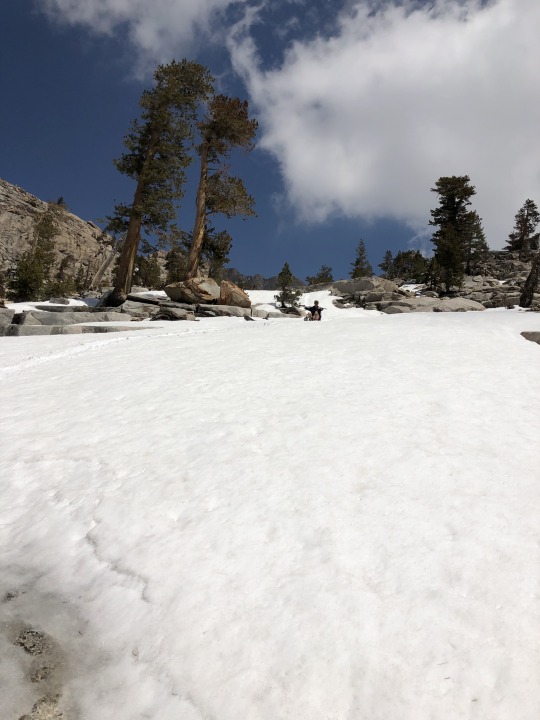
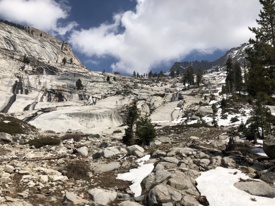
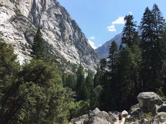
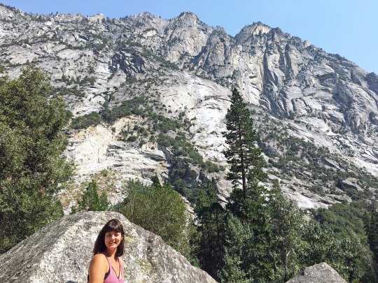
Mt Silliman from Lodgepole Visitor Center, Sequoia National Park

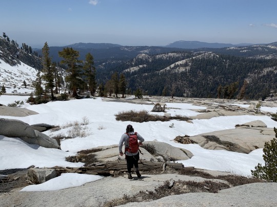
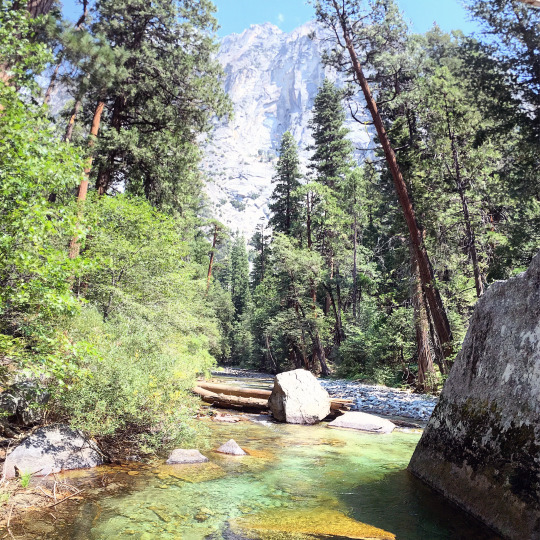
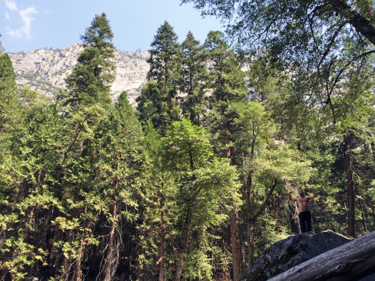
Colin had a free weekend so he was keen on getting a trip together. He was most interested in Mt Silliman which lies in Sequoia National Park. I had hoped to save this peak for when I was in a pinch and needed an easy SPS peak, however I decided that Colin’s company was too good to pass up. Mike Toffey also agreed to join us, which gave us an opportunity to have a nice little reunion post Kandlbinder Peak outing. Inspired by Sean King and Chris Henry’s snow climb a month earlier, we hoped to challenge ourselves with some spring conditions. We watched the daily satellite and observed the snow receding at a very fast rate. We decided to bring our crampons and ice axes with us, and we planned to make the call on what to carry after seeing the conditions first hand at the trailhead. I offered to drive, so on a Friday afternoon, I picked up both Colin and Mike from San Jose then drove across the valley to the SEKI northern park entrance. We found a section of national forest land where we slept. Colin and Mike set up tents above the road, while I slept in the car parked near a closed gate. I was disturbed at 2am with high beams penetrating my car. There were two PG&E trucks and they were fiddling with the gate so that they could tend to some issue further up the forest road. I was not blocking the gate, but I was in their high beam’s line of fire. It took them a remarkably long time to open such a simple gate, and needless to say I was pretty upset. I caught a couple more hours of sleep after they finally passed through, but I didn’t quite get the well needed good night’s rest that I had hoped for. The next morning we piled back into my car and drove the remaining 18 miles down General’s Highway to the Lodgepole Visitor Center. Colin threw up on the drive; was it car or altitude sickness? I could have parked closer to the Lodgepole Campground, but it was my first time in the area and simply parked in the first lot after turning off the freeway. This folly added about a half mile of extra pavement walking each way, but we were in high spirits and expected a moderate day to begin with. We left the snowshoes in the car, but brought along our crampons and ice axes. We crossed the Marble Fork of the Kaweah River then started up the Twin Lakes Trail.

We started off at a strong clip. I was hoping to get my Sierra hiking legs back under me but my body screamed in agony. My lungs, legs, feet and brain protested as I walked up the gradual trail. It usually takes me a few Sierra hikes to get back shape, but I was in exceptionally poor conditioning after a multiweek trip to El Salvador. I pretended to analyze the foliage to make excuses for my constant little breaks. The Mountain Misery was one of the prime candidates of interest due to it’s recognizable and nostalgic scent.
We followed the Twin Lakes Trail for 2.2 miles. Prior to crossing Silliman Creek, we picked up a well trodden use trail that stayed along the southeastern side of the creek.
We continued up to Silliman Meadow wondering when we would finally hit some snow.


The trail remained generally easy to follow, aside from the occasional fallen tree that had us make small diversions.

The trail ended at some granite slabs at a fork in the canyon. Many trip reports mentioned these granite slabs so we continued up the right fork of the canyon.

Snow patches had started to appear. They were melting fast and water was running all around us. We decided to keep our gear in the pack and find a snow free friction route up the smooth granite.


-Sierra Stonecrop

The patches of snow that were unavoidable were easy to walk across.
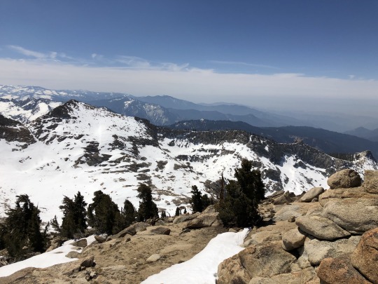
We reached Silliman Lake at just over 10,000 ft. It was still covered with ice.

From here it looked like the peak was to our east, but in reality it was more to our north.
Although it seemed counterintuitive, GPS corrected my assumption and we continued on our way towards the summit. Again we were able to pick a mostly snow free route, now that we were on the exposed southern side of the peak.


I could have found a class 2 route to the top, but that would have been too boring. I aimed for the ridge and once there, picked a fun class 3 route along the top of the ridgeline. It was very benign, but I’ve seen some YouTubers refer to this as “Death Drop Ridge”. They used a fish goggle lens to make their periphery appear more exposed. Most viewers end up being fooled by this trick, and they get a lot of views because of it. I find the whole mountain influencer culture to be fraudulent and pathetic.
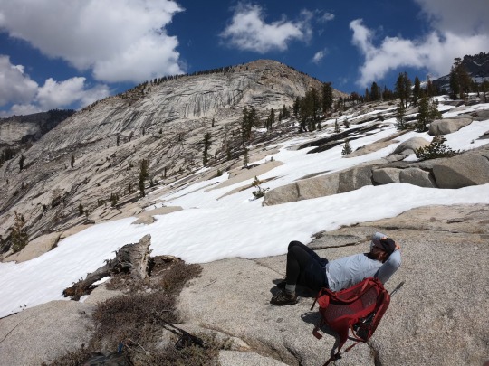
Mike came up to join me while Colin stayed slightly below the ridgeline. The western summit was rather impressive with a nice layer of snow.
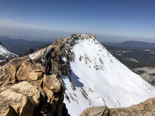
It wasn’t much longer until we reached the summit. We didn’t need our crampons or ice axes once.

To the northwest ran the Kings-Kaweah Divide.
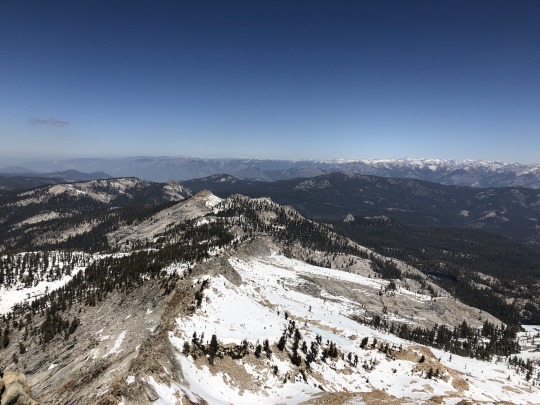
To the northeast was the gash in the Salinian Block that is Kings Canyon.

To the east stood the Great Western Divide.
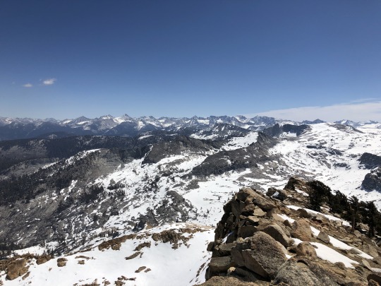
To the southeast was the Kaweah Range. Black Kaweah looked exceptionally striking.

To the southwest were Panther Peak, Moro Rock and the southern entrance of Sequoia National Park.
To the west was the hazy San Joaquin Valley.

Things were going well I felt, but out of nowhere Colin started to feel sick. It was not long before he started coughing, then some vomiting ensued.

Mike and I gave Colin some time, since it was early and we had nowhere we needed to be. Once he got everything out, we started back down, expecting his symptoms to improve once at a lower elevation.
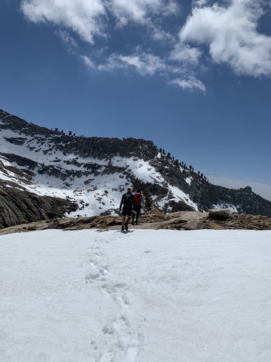

The descent was very fun. I found safe snow patches that were glissadeable, both on our feet and on out butts.
Other sections had me stomp through the soft snow. Water was flowing everywhere and it was quite magical.


Then out of nowhere, Colin unexpectedly got sick again. We were much lower in elevation now so Mike and I were a bit perplexed as to why his nausea had returned. Only this time it was coming out of both ends.

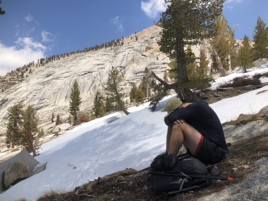
Mike and I chose a spot to rest down below to give Colin some privacy.
Once he was strong enough to continue, we dropped down the rest of the slabs and found the use trail.
I remember walking back and studying Colin’s body language. He was clearly hurting, and I could sense the negative energy coming from his body. Colin is usually the friendliest and happiest guy, but this was a time that he didn’t want to talk. Instead I focused on chatting with Mike about stupid things, things that probably unintentionally irritated the hell out of Colin. One I realized this, I went back to studying the forest, mostly learning about Wolf Lichen, which for the longest time I thought was moss.

Colin started to feel a little better as we reached the trailhead. As we walked through the Lodgepole Campground, I noticed that entire sections of the campground were closed while others remained open to full capacity. This was most likely done as a Covid precaution, but was completely idiotic. They could have easily closed every other site to allow for more intra-camper distancing, however instead they decided to jampack all the campers into one small, dense section of the campground. I’m sure the mouth breathers of the park service believe that they saved lives by doing this. We hopped back into the car and began our drive back home, but I had to pull over a few times for Colin to throw up some more. What madness! He finally was able to keep food and liquid down once at the low elevation town of Squaw Valley. We still don’t have a good explanation for why this keeps happening, but I hope Colin figures it out soon, as he appeared to be in a lot of discomfort that day. All in all, it was good to bag another Sierra Nevada Peak, and while we didn’t get the snow we had hoped for, it was still a fun day in the mountains.
0 notes
Photo
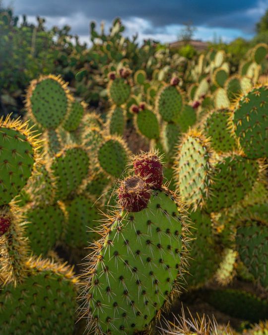
Prickly beautiful. - #speysyde #Landscape #ZCreators (at El Moro Campgrounds (Crystal Cove State Park)) https://www.instagram.com/p/CI8TkO9FY2x/?igshid=1gohcs61bkvr1
0 notes
Text
Kings Canyon and Sequoia National Parks for #NPS100
We are true weekend warriors, willing to travel really far distances for very short amounts of time. This time we drove 6.5 hours from San Diego to celebrate the National Park's centennial anniversary at King's Canyon and Sequoia National Parks for a mere 36 hours of time in the parks...
The National Parks actually celebrate their anniversary every year for the weekend of August 25th with free entry to the parks, but this year was especially important because it was celebrating the 100 year anniversary! #NPS100
We stayed at Sunset Campground in Hume, California smack dab between the two parks. Leaving straight from work and braving the LA rush hour traffic, it took closer to 7.5 hours to arrive in the pitch black night around midnight. Our camp site was unfortunately not very private, nor level, and happened to also be set on a bed of stone just below the soil. So we slept on a complete slant, slipping down through the night, without our tent anchored in - the things we do. On to the positive...
Kings Canyon National Park
We really enjoyed this underrated and less crowded National Park. The landscape of King's Canyon felt similar to Yosemite, but without all the people, so we affectionately called it Yosemite Jr. Huge granite rocks towered above our heads, spiking out in to pinnacles and enveloping you with the magnitude of their size. Boulders were strewn across the canyon floor, and King's River rushed by us as we traversed through the forest of pines, redwoods and sequoias surrounding us. It was silent and peaceful, and the portion of the trail we were on was basically flat the entire time as it followed the river through the canyon.
Things to see & do:
General Grant Tree: One of the largest giant sequoia trees in the world (we'll get to the largest one in a minute...), this tree is set in a forest of sequoias with plenty big trees to take in.
Road's End trail towards Misty Falls trail: This trail was great because it was so undisturbed. No cars, bikes or shuttles, just a few people enjoying the wilderness. This trail also leads to a 4-5 day backpacking loop which connects to the PCT. If you come to the trail more prepared than we did, you can make your way to the waterfall at Misty Falls.
Wildlife: We (luckily) didn't see any bears, but this area is much more wild and an active black bear zone. We saw tons of lizards, insects, and even a rattle snake (he slithered away unbothered).
Swimming: We skinny dipped in King's River (we forgot our suits). The water is really cold, but it is relaxing and refreshing even just to dip your toes in.
Kings River
Magpie flexing post skinny dip
--
Sequoia National Park
Giant sequoias are the world's largest single trees and largest living thing by volume. The trees are ancient, the oldest known one being 3,500 years old. Being amongst them knowing they were here long before us, and will still be there long after us is amazing. Their bark's evolutionary resiliency is also impressive. It it not only fire resistant, but actually depends on and thrives in forest fires, eliminating competing vegetation, and setting the stage for their cones to open.
In addition to housing the largest sequoia trees in the world, Sequoia National Park also boasts the largest mountain in the lower 48: Mt. Whitney, making the park's designation extend vertically nearly 13,000 feet.
Things to do & see:
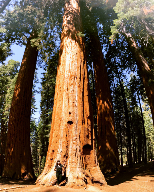
General Sherman Tree: The largest living organism on earth and the biggest tree in the entire world in terms of density. There are other taller or wider tress, but none with as dense of wood in the trunk. Beware: this area is very touristy and crowded.
Crystal Cave: This drive was off the cut and quite out of the way. Entrance to the actual cave requires an $18, 1 hour guided tour. We opted just for the lush hike down along a waterfall that dipped down each layer of rock deviating directions ever so slightly. The walk back up from the bottom was definitely a work out!
Big Tree Trail: A peaceful walk amongst the giant sequoias overlooking a vast meadow. Learn about the trees, climb through hollowed out fallen soldiers, and admire how small and young you feel next to these thousand year old warriors.
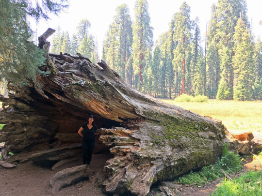
Fallen sequoia tree on Big Tree Trail
Moro Rock: This was definitely the highlight of the trip! The trail leading up to the rock is 1.6 miles each way, and the majority of the hike is through a shaded forest area that is serene and easy to traverse without much elevation gain. Then for the last quarter mile you head straight up Moro Rock to an unexpectedly breathtaking view of the high Sierra Mountains. The last portion of the hike felt a lot like a safer, easier Angel's Landing. There is a shuttle at the bottom of the rock that can take you back, but it is super crowded, so we just headed back the way we came on foot.
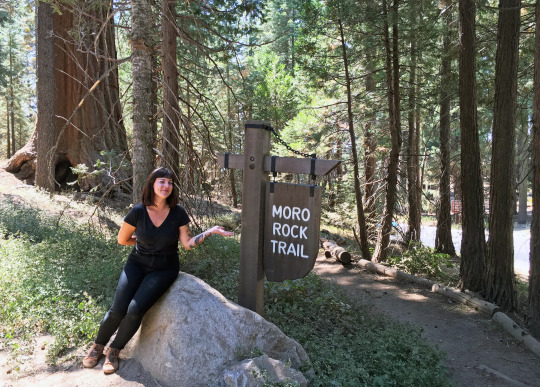
The beginning of the trail. Mostly shaded and flat amongst sequoia trees and ferns.
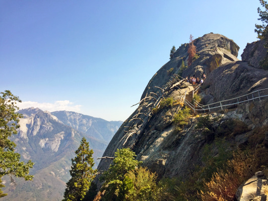
Our first look at the stairway to the top of Moro Rock (we had no idea this was ahead)
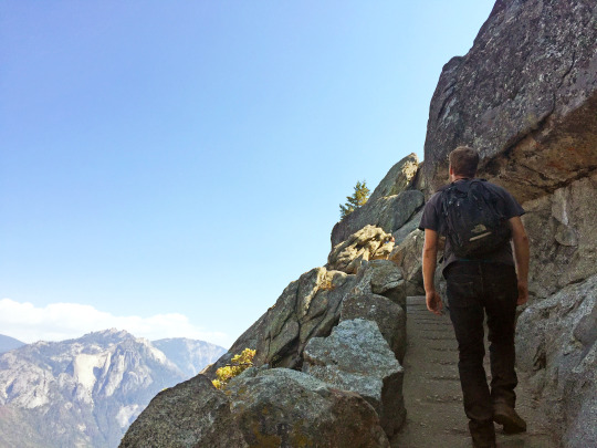
The long climb...
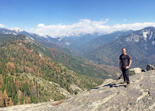
The summit...
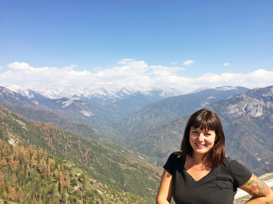
Oh the views...
All in all these parks are great to visit. It's nice that they are both right next to each other, making for so much to do over your stay. The views are stunning, the magnitude of the canyon is immense, and the resiliency of the giant sequoia trees is inspiring. And since 84% of Sequoia and Kings Canyon National Parks is designated wilderness, meaning accessibility is available only by foot or horseback, it makes for a very private encounter with nature and smaller crowds (even on a free entry weekend).
Have you been to these parks? We'd love to hear about your favorite sights in the comments.
'Til next time, stay wild!

0 notes
Photo
Don’t get #groundshots get #aerialshots call our #expert #droneteam for #aerialphotos !!! . . #CommercialDroneVideo #AerialDroneVideo #DroneOfTheDay #DroneGlobe #UAV #UAS #DroneBois #DJI #AerialPhotography #DJIPhantom #DJIPhantom3 #DJIPhantom4 #FromWhereIDrone #Mavic #Phantom #HexaCopter #OctoCopter #DroneLive #LiveDroneBroadcast #DJIcreators #DroneMultimedia #FPVaddict #DroneRacing #IAmDJI (El Moro Campgrounds (Crystal Cove State Park)) https://www.instagram.com/p/BsrEwUMj0ob/?utm_source=ig_tumblr_share&igshid=f0cymdqeofxn
#groundshots#aerialshots#expert#droneteam#aerialphotos#commercialdronevideo#aerialdronevideo#droneoftheday#droneglobe#uav#uas#dronebois#dji#aerialphotography#djiphantom#djiphantom3#djiphantom4#fromwhereidrone#mavic#phantom#hexacopter#octocopter#dronelive#livedronebroadcast#djicreators#dronemultimedia#fpvaddict#droneracing#iamdji
0 notes
Text
The thing that blows me away every time is that we can leave our place, drive down to Sea-Tac, park with Doug Fox, take their bus, ride a coupla elevators, check in and check our bags, and get all the way through TSA in under an hour.
Just barely. But still.
Just under one hour.
I wanted to put that out there because I really am amazed when that happens. Especially this time around with everyone heading out for Spring Break.


So where... are we going?
Well, we're hanging out with family at Moro Campground, Crystal Cove State Park. Only...
We missed the reservation window at the top of this year because we were dealing with the unexpected death of Kimmer's uncle and the logistics that played out during the week after he died. Consequently, we do have a coupla days somewhere in front of us at Crystal Cove but most of the time we're at Lake Perris Campground which is just this side of the mountains before Palm Desert and Palm Springs.
This is also usually the time Kimmer's down here to check in on her aunt so, while we're in the neighborhood we'll do a little double duty.


Now, we've done this Crystal Cove trip a number of ways at a number of times over the years. Last year, though, we rented an Escape Campervan from their Des Moines location just south of Sea-Tac and drove the full route from home 'n back.
On our return, we had a little trouble with our van, "Nessie", and switched it out in Inglewood. While we were at that location, Kimmer got to talking with one of the associates who explained how a lot of their clients fly into LAX, Uber or Lyft themselves and their gear the couple miles to the Inglewood lot, load up, and drive off on their adventures from there.
We actually proof of concepted that concept for ourselves when we flew into Salt Lake City last year and adventured with an Escape Campervan to all the National Parks in the south of the state.
This time around, because of how our pair of reservations went down and how we're coordinating our schedules with family, we've got a few days before we've got to pick up our ride from Inglewood. So we're flying into our favorite airport, Long Beach, renting a car (Go Alamo!), and killing some days in Orange County starting with Universal Studios Hollywood later this morning where, due to a very random aligning of the planets, we're gonna see Linzy's old high school band, the Wildcats, performing because they're actually down here right now with gigs at Disney and Universal.
Crazy how that worked out... but we're very much looking forward to hanging out with the band director again. 😊

Okay. One last thing.
Yesterday morning, while we're at the airport waiting on our first flight, Kimmer turns to me and says
"So... are you amazed at my packing job?"
And the answer, which should've been an unqualified Yes... wound up being a qualified Yes. You see, our big bags of gear are subject to Southwest's fifty pound limit in order to avoid fees... and she came in at 47 and 47 and a half using the scale at our place. Which is really, really good. Only...
At the end of our Utah trip last year, she came in at 49 and 50 by dead reckoning. No scales involved.
Now that.
Was really impressive. 😁
Anyway...
It's a little vacation for us, a bunch of family, some coordinating Kimmer's gonna do on her aunt's behalf, a bit of catching up with an old friend, and yes... doing a touch of work on the road 'cause that was always gonna be unavoidable.
Still...
It's an adventure.
And we're on it.
☺️

0 notes
Text
The Ultimate Two-Week California National Park Road Trip Itinerary • The Blonde Abroad
Rachel + Dana of Traveling Found Love are here today sharing this epic California national park road trip itinerary!
One thing is for sure, California’s vibrant cities and the stunning Pacific Coast Highway attracts millions of visitors every year. We loved walking on the Santa Monica Pier and admiring the amazing views on Highway 1 but what really left us speechless was the inner part of California.
As outdoor lovers, we are always up for an adventure in a national park. On this route, you will pass through five exceptional parks with undeniably gorgeous landscapes and some of North America’s greatest natural wonders.
From the lowest point in Death Valley National Park to the highest waterfall in Yosemite National Park and not to forget the largest tree in the world in Sequoia National Park.
Ready to get off the beaten path for an unforgettable 2-week California national park road trip from San Diego to South Lake Tahoe?
We would recommend doing this road trip from spring to fall since there can be road and trail closures in some parks due to snow in the winter months.
When Should You Take This Route?
The National Parks and Lake Tahoe are beautiful all year round and each season will provide you with different and unique experiences in the parks. From beautiful wildflowers in the spring in Death Valley to the incredible fall foliage around Lake Tahoe.
Nevertheless, we would recommend doing this road trip from spring to fall since there can be road and trail closures in some parks due to snow in the winter months. To stay up to date on road information and conditions it is best to check the national park website before your trip.
We completed our trip during the summer. The weather was always beautiful and sunny but extremely hot, especially in Death Valley and Joshua Tree National Park.
If your trip includes outdoor activities, it is best to complete them in the early morning or late afternoon. You will want to limit these activities during the middle of the day since you can experience scorching temperatures. Always remember to have lots of water with you!
Our 14-Day Road Trip Itinerary
Day 1-3: San Diego
Day 4-5: Joshua Tree National Park
Day 6-7: Death Valley National Park
Day 8: Sequoia National Park
Day 9: Kings Canyon National Park
Day 10-12: Yosemite National Park
Day 13-14: South Lake Tahoe
The Coolest Airbnbs in California
Here are the coolest (and most charming) Airbnbs to stay at in California!
Read More
Day 1-3: San Diego
San Diego is a must-see city on the West Coast and one of our ultimate favorites.
It offers a lively downtown area with awesome nightlife possibilities, tons of beaches to unplug, wildlife encounters at La Jolla Cove, and incredible parks to wander around in.
When you want to combine a relaxing afternoon on the beach and a unique hiking experience, don’t miss out on the Ho Chi Minh trail which brings you right to the shore. It is a bit of a climb through a sandstone passage but we had a lot of fun on this little adventure.
Best Things to Do and See in San Diego:
Visit the famous San Diego Zoo
Stroll around Balboa Park
Experience Downtown: Gaslamp Quarter, Seaport Village, Little Italy
Admire the sea life at La Jolla Cove
Hike the Ho Chi Minh Trail, a unique hiking trail that leads you to the Blacks Beach
Soak up the sun on one of San Diego beaches: Mission Beach, Pacific Beach
Go on a hike through Torrey Pines State Natural Reserve for stunning overlooks of the Pacific Ocean.
Catch a sunset at Sunset Cliffs Natural Park
Where to Stay in and Around San Diego
Ranchos Los Coches RV Park (20 minutes east of San Diego) This family-owned campground is a great place for RV traveling and tent camping. Another plus is the prices are cheaper since you are a little outside the city.
Day 4-5: Joshua Tree National Park
Drive from San Diego to Joshua Tree National Park (south entrance at Cottonwood Spring)
[Approx. 158 miles | 3 hours 20 minutes]
Experience how two deserts, Mojave and Colorado, come together to create a unique landscape in Southern California.
Snapping a picture with the spiky Joshua Tree is a must. But don’t forget to experience the diversity of the lush and rocky landscape in the park up close on one of the incredible hikes.
Keep your eyes open for wildlife on your hikes! We were lucky to spot a chuckwalla (lizard) and a rattlesnake underneath a rock.
Best Things to Do and See in Joshua Tree National Park
Take a scenic drive through the park
Check out the unusual Cholla Cactus Garden
See impressive rock formations: Skull Rock and Arch Rock
Admire the panoramic view of Joshua Tree from the highest point at Keys View
Take a hike on the Barker Dam Trail
Where to Stay in Joshua Tree National Park
Camp out in one of the national park’s campgrounds!
Day 6-7: Death Valley National Park
Drive from Joshua Tree National Park (north entrance at Twentynine Palms) to Death Valley National Park (east entrance via Highway 190)
[Approx. 228 miles | 3 hours 50 minutes]
Death Valley is the hottest, driest, and lowest of all the U.S. National Parks. You can expect a true desert experience from climbing up the Mesquite Flat Sand Dunes, standing in salt flats at Badwater Basin, to admiring surprisingly colorful patterns on the Artist’s Drive.
You also have to see Death Valley from above, the views from Zabriskie Point and Dante’s view are breathtaking.
Best Things to Do and See in Death Valley National Park
Take in the views of Death Valley at Zabriskie Point and Dante’s View
See a salt pan at Devils Golf Course
Visit the lowest point in North America at Badwater Basin
Journey down Artist’s Drive to see the beautiful colors of Artist’s Palette
Explore the sight of Harmony Borax Works in Furnace Creek
Walk on the dunes at Mesquite Flat Sand Dunes
Where to Stay in Death Valley National Park
Stay in one of the park’s campgrounds from late fall until spring. We would not recommend camping in this area during the summer months due to extreme heat. For a more delicate experience book a room in one of the park’s lodges.
Kings Canyon National Park – General Grant Trail
Day 8-9: Sequoia & Kings Canyon National Park
Drive from Death Valley National Park (west entrance at Panamint Springs) to Sequoia National Park (Ash Mountain entrance at Three Rivers)
[Approx. 268 miles | 4 hours 45 minutes]
Drive from Sequoia National Park to Kings Canyon National Park via Generals Highway
[Approx. 10 miles | 20 minutes]
Home to the largest trees in the world, Sequoia and Kings Canyon National Park are truly the land of giants.
What will be your favorite way to experience the land of giants?
Is it feeling like a tiny ant standing next to these massive trees, seeing inside of a tree while walking in Grant Grove or driving through a fallen sequoia tree at Tunnel Log?
Best Things to Do and See in Sequoia and Kings Canyon National Park
Hike up Moro Rock
Drive through a fallen sequoia tree at Tunnel Log
Stand next to the largest tree in the world on the Congress Trail: General Sherman Tree
Hike around the General Grant Tree and walk through the fallen Monarch in Grant Grove
Take a Scenic Drive on Kings Canyon Scenic Byway
Stop and see Grizzly Falls on Kings Canyon Scenic Byway
Enjoy the scenery at Zumwalt Meadows
Where to Stay in Sequoia & Kings Canyon National Park
Enjoy a night in nature at one of the many campgrounds throughout the parks. Spend the night in one of the lodges within the park for a cabin retreat!
Day 10-12: Yosemite National Park
Drive from Kings Canyon National Park (Grant Grove Village) to Yosemite National Park (south entrance via Highway 41)
[Approx. 111 miles | 2 hours 15 minutes]
Yosemite National Park is not only California’s most visited National Park but one of the top ten in the U.S. The park is best known for its impressive waterfalls, especially Yosemite Falls which is the highest in North America.
Enjoy the stunning views on the scenic drive, have a picnic at one of the lakes, and when you are up for a real adventure, take a strenuous hike up Half Dome or Vernal falls.
For a romantic ending of the day, drive up to Glacier Point to see the iconic Half Dome shining in the orange and red lights of the sunset.
Best Things to Do and See in Yosemite National Park
Explore Yosemite Valley
Take a Hike: Lower Yosemite Falls, Vernal Falls, Bridalveil Falls. Or take on the challenging 14-16 hour hike up Half Dome (permit required)
Stop and see El Capitan: best views are at Bridalveil Falls area, the western part of Yosemite Valley, and Tunnel View
Capture a photo at Tunnel View
Catch a sunset at Glacier Point
Take a drive on Tioga Road to Tuolumne Meadows
Have a picnic by Tenaya Lake
Important Info
During the winter and spring months Tioga Road, Glacier Point Road, and Mariposa Grove Road are closed.
Where to Stay in Yosemite National Park
Day 13-14: South Lake Tahoe
Drive from Yosemite National Park (east side via Tioga Pass Road) to South Lake Tahoe
[Approx. 131 miles | 2 hours 45 minutes]
Lake Tahoe is truly enchanting with its crystal clear turquoise water and the surrounding forest and mountain sceneries. You will get the best views from Emerald Bay State Park Campground which is located on the southwest part of the lake.
From there, take the Rubicon Trail down to the lake to enjoy the cool water in a kayak or while swimming around. For a great cultural experience tour the unique Scandinavian Vikingsholm castle.
Best Things to Do and See in South Lake Tahoe
Visit a State Park: Emerald Bay State Park or D.L Bliss State Park
Hiking: Rubicon Trail, Balancing Rock Nature Trail
Water Activities: kayaking, paddle-boarding, boating
Take a tour of Lake Tahoe’s hidden castle: Vikingsholm Castle
Where to Stay in South Lake Tahoe
Spend a night at Emerald Bay State Park or D.L. Bliss State Park
Trip Additions
We take every chance to admire colorful street art and artsy creations wherever we go. If you are also into art, take the 50 minutes detour to Salvation Mountain on your way to Joshua Tree National Park. It is just a quick stop but the visionary environment on the hill is indescribable, it is best to see it for yourself!
When you have some extra time, make a stop at Las Vegas on your way to Death Valley National Park for a little sinful fun on the Las Vegas Strip.
For more original Vegas vibes, don’t miss out on the “old strip” around Fremont Street. Here you find beautiful original casinos that are worth checking out even when you are not into gambling.
A great way to end the day is to go to one of the dozen buffets which serve whatever you can imagine. Our all-time favorite is the Wicked Spoon. Make sure to arrive hungry…
Lastly, if you have even more time, think about making a loop back to San Diego via the California coast.
Helpful Tips
For those who want a time out from technology, this is your chance to unplug and enjoy the view, feel, and smell of nature because you will be lucky to find any service while in the parks.
If you are traveling by campervan or RV, we recommend campendium.com to find cheap or free spots to stay for the night. Campgrounds in the national parks in California book out months in advance, so make sure that you reserve your favorite campsite in time.
But don’t worry, even when you can’t get a site on a campground, there are National Forests and BLM (Bureau of Land Management) land where you can stay completely for free.
Another great way to save money on this 2-week California national park road trip is to purchase an America the Beautiful pass. This pass will give you access to a full year of national park adventures all over the USA.
Source link
قالب وردپرس
from World Wide News https://ift.tt/30DzW2Z
0 notes
Text
20+ Famous National Parks in the USA that you Need to Visit – Part 2
This curated list of the Best USA National Parks is in continuation to this Best National Parks in the USA for Adventure and Nature Lovers – Part 1
[toc]
Joshua Tree National Park
Joshua Tree National Park is often overlooked when compared with other famous USA National Parks across California, but it’s actually a spectacular place for adventure and nature lovers to visit. It’s such a unique and unusual place, and visiting Joshua Tree National Park is a wonderful idea no matter the time of year!
Nature lovers will enjoy this park in particular because of the Joshua trees, which are the unique plants that give this park its name. These trees have a single trunk that then branches out into spiky leaves, giving them a somewhat alien and unfamiliar appearance as they sprawl throughout the desert. If you’ve never seen Joshua trees before then you will definitely want to visit this park to see them for yourself! Joshua trees only grow in the Mojave Desert (southwest California, Nevada, Utah, and Arizona) so this is one of the very few places in the world that you can see these unusual trees.
Adventure lovers will also enjoy this park because of its myriad hikes, as well as the amazing boulders and rocks scattered throughout the park that are perfect for bouldering and rock climbing. There’s even one famous rock formation here called the Great Burrito, which you will want to be sure to climb! You can bring your own gear and enjoy climbing on your own, or there are also independent tours available that will give you gear to use and can help guide you to some fun places to climb in the park.
Be sure to bring water and food with you, as there are no amenities for food or water in the park, as well as bringing sunscreen, sunglasses, and hats to protect you from the sun. It’s a beautiful place, but there aren’t too many places to enjoy shade while exploring here! But whether you’re here for hiking and rock climbing or here for the Joshua Trees and other spectacular desert landscape features, you’ll find plenty to occupy you during your time in the park. And one thing’s for sure…after visiting Joshua Tree National Park, you will definitely want to return again and again!
By Abi Johnson | Happy Go Abi
(adsbygoogle = window.adsbygoogle || []).push({});
Mount Rainier National Park
One of the best national parks in the USA to visit is the Mount Rainier National Park. This outstanding park is filled with mountain views, lakes, waterfalls, flowing rivers, and old grove trees. It is one of the best places to visit in Washington for an adventure. There are so many hikes, wildlife, and outstanding viewpoints. It is a perfect place to visit this summer.
One of the best places to visit is the Paradise Visitor Center. Just driving to this center will make your jaw drop. The views are beautiful throughout the drive, and there are some viewpoints you can stop to take pictures. If you get here in the summer, the area is filled with beautiful, colorful wildflowers.
One of the best hikes to do is the Skyline Trail. It is the most popular hike in Mount Rainier but for a good reason. You get up and front views of Mount Rainier throughout the whole trail. There is also a good chance you will spot wildlife, and at the end of the hike there are views of the stunning waterfall: Myrtle Falls. It is such a beautiful hike.
Another great hike to do is comet falls. This is a great hike to do on cloudy or rainy days. The waterfall looks magnificent, even when the weather does not work in your favor. There are also other waterfalls and river views throughout the hike. And the enormity of this waterfall will surely take your breath away.
Another popular hike to do with the whole family is the Grove of the Patriarchs Loop. It is an effortless trail to go with the family with stunning old-growth trees. The trees are humongous. Once you are done with that trail, make sure to head on over to Silver Falls Trail. It is one of the most stunning waterfalls in the area with few crowds. The bright green tree colors with the blue-green river provide outstanding photos.
The last hike I highly recommend is the Fremont Lookout Trail. It is highly recommended to do this trail for sunset. The colors of the sunset with the views of Mount Rainier in the backdrop are out of this world. You won’t want to miss it.
Mount Rainier is filled with countless activities. You can spend weeks here and still not even be close to exploring it all. It is such a beautiful national park for an adventurer.
By Michelle Stelly | The Wandering Queen
North Cascades National Park
The North Cascades National Park in Washington State is without a doubt one of the best national parks in the USA for adventure lovers. The park is often called “The American Alps” due to the glacial mountain peaks, forested valleys and emerald green lakes. The terrain here is rugged which means hikes tend to be on the more strenuous or difficult side but the views are well worth the effort!
The mountains in the park form part of the Cascade Mountain Range; so-called due to the many, many waterfalls found in it. This mountain range runs from British Columbia all the way to northern California. The Pacific Crest Trail goes through the park too before it finishes just across the border in Canada so you may see thru-hikers coming to the end of their journey in late summer.
Adventure and nature lovers should make sure they take a drive along the North Cascades Scenic Highway (check that the road is fully open with the National Parks Service beforehand), taking time to admire Diablo Lake. Don’t miss out on the Washington Pass Overlook either. An easy, accessible quarter-mile walk takes you to a stunning overlook with towering granite peaks and alpine beauty. Of course, you shouldn’t miss out on the chance to take a hike as there are some beautiful hikes in North Cascades National Park.
Cascade Pass makes a great day hike with beautiful views of some of the glaciers and peaks in the park. As you reach the pass you’ll be treated to views of Eldorado, Johannesburg, Magic, Mixup and McGregor. It’s also one of the best bang for your buck hikes in the park. Just make sure you start early as this trail gets busy in the summer.
Nature lovers will love hiking in North Cascades between the months of May to early September as this is when the wildflowers come out in full force. There’s also plenty of wildlife living in the park including black bears, so make sure you take bear spray if you’re hiking!
By Hannah Kacary | That Adventurer Blog
Olympic National Park
If you’re one for wildlife, temperate rainforests, outdoor adventure, and a just “little” rain, then Olympic National Park should certainly be top of your National Parks in the USA Bucket List. With rugged coastlines that are perfect for sea kayaking to primitive, rugged alpine trails with plenty of climbing terrain, this often-overlooked-peninsula is an adventure-junkies dream.
Beware, Olympic National Park can be a pretty busy place in summer. The 454-mile loop road that takes you around the entire park and peninsula dips in and out of some of the most beautiful spots of the park. But don’t worry, most visitors are heading over to Hurricane Ridge which provides an easily accessible view of Mt. Olympus for all to enjoy (when it’s not in cloud cover, that is).
But you’re not coming all the way to Olympic National Park to sit in a car. Even though it may rain a lot (it’s actually one of the wettest places in the lower 48), there are plenty of places for outdoor adventures.
Backcountry or multi-day hiking: If you’re only looking for an advanced overnight hike or one very long day in the high alpines, the 19-mile round-trip 7 Lakes Basin offers some of the best views of Mt. Olympus. Depending on what time of year, hikers can keep their eyes peeled for black bears, black-tailed deer, bald eagles, and cougars.
For more moderate hikes head over to Enchanted Valley for some incredible views, waterfalls and glaciers. If you want to experience the most remote and rugged coastline in the U.S., head over to the 73 mile long North Coast Trail along the Olympic Wilderness Coast.
Trekking through the rainforest: The Hoh Rainforest provides some of the most unusual moss-covered rainforests, providing fantastically spooky photo opportunities. Take a short stroll around Hall of Mosses Trail, or take your trek a little further down the Spruce Nature Trail for some up-close views of the impressive Sitka Spruce Trees and Hoh River.
Watersports: If water adventure is more your thing, there are plenty of lakes, rivers, and shorelines to explore within Olympic National Park. From multi-day sea kayaking adventures off of Ruby Beach to rafting down the Hoh River, the water choices are endless.
For a real outdoor experience, camping in Olympic National Park is an excellent place to be one with nature. Just ensure your camping gear is up to the 140 inches of rainfall the park gets every year.
By Nick Winder | Impact Winder
(adsbygoogle = window.adsbygoogle || []).push({});
Sequoia & Kings Canyon National Park
Often overlooked by the almighty Yosemite, Sequoia and Kings Canyon National Park is a must visit if you are in California and want an adventure like no other. Nature lovers will appreciate everything this national park has to offer. Camp out by a fire pit and stargaze or take a hike in the High Sierra past alpine meadows and towering trees. Look out for the majestic black bear and marmots scurrying by as you stroll through the most incredible landscapes.
A favourite hike of mine is the one to Tokopah Falls, start at Lodgepole Campground and follow the trail until you hear the sounds of rushing water. Head there early in the morning to have it all to yourself.
For adventurers climb the 400 steps carved into the side of Moro Rock to reach the top. This exposed granite dome has incredible panoramic views of the High Sierra Mountain Range and most of the park all the way to the top. The highest point is at an elevation of 6725ft and the vista is breathtaking.
The monumental trees this park is famous for are awe inspiring, stop by General Sherman Tree, with a circumference of 102ft and standing proudly at 275ft high it is by volume the world’s biggest tree. In Grant Grove walk through the trunk of the Fallen Monarch and go just slightly off the beaten track to avoid the crowds and admire these beauties all by yourself.
Entrance passes to the park can be purchased online or at the park gates, there are no gas stations within the park so be sure to fill up before arrival.
For those that love getting back to nature there are some wonderful campgrounds, most sites come with a bench, fire pit and bear box storage; book up to six months in advance. I loved staying in a rustic cabin in Grant Grove Village, it’s a unique experience and if you like a little more luxury than camping then this is the one for you. The cabins are within walking distance of the General Grant Tree and a restaurant and small store are nearby.
By Nicola Dunkinson
Shenandoah National Park
One of the best national parks in the USA, on the East Coast for nature or adventure lovers is Shenandoah National Park. Located in central Virginia just above the Blue Ridge Parkway, Shenandoah is one of many wonderful places to hike and take in nature close to Washington, D.C.
Best known for its gorgeous foliage in the Fall, Shenandoah is also at its most crowded at this time, with cars almost bumper to bumper along the famous Skyline Drive. Plan on getting up early or exploring on a weekday to beat the crowds, since visiting in the Fall is a must. If you want to plan your trip around peak foliage, the park’s website has a foliage tracker each year to estimate the perfect time to visit.
For those looking for a bit more adventure than staying on the main road, there are more than 500 miles of hiking trails throughout the park. The most popular trails feature waterfalls or mountain overlooks, but the forest and meadow trails should not be forgotten. Shenandoah is organized by three sections, the North District, Central District, and South District, and each one offers spectacular trails.
The North District is the section closest to Washington, D.C. and is only an hour and a half away. The most popular and most challenging trail, Old Rag Mountain, can be found in the Central District. The majority of the waterfall hikes can be found in the Central and South Districts. Whiteoak Canyon is the best waterfall hike with 6 waterfalls along the trail. The national parks service does a great job of breaking down all the trails here to help you choose the perfect hike for your skill level.
The Appalachian Trail also cuts through parts of Shenandoah, so hikers can try out how it feels to walk on this historic trail. To add even more excitement, there are frequent black bear sightings, so make sure you brush up on your bear safety information before hitting a trail.
Whether you visit during the popular months of Fall or any time of year, Shenandoah National Park is the perfect bucket list destination for any nature or adventure lover.
By Jordan Bradford | The Solo Life
Smoky Mountain National Park
If you’d love to spend entire days in the great outdoors, then you should definitely consider visiting the Great Smoky Mountain National Park. This portion of the Appalachian Mountain Range is located throughout Eastern Tennessee and North Carolina. Since the plant and animal life in this region is different from the rest of the country, nature lovers will definitely be in awe! If you’re more interested in backpacking and camping, you can apply for a permit and hike along the entire Appalachian Trail, or simply throughout this park.
Mt. LeConte, which is one of the highest mountains in the Eastern United States, actually has lodging at the top of the mountain if you’d like to plan an overnight trip (although you will need to schedule this months in advance). Five trailheads lead to the top of this mountain, including Alum Cave (which is my favorite), Rainbow Falls (which is fairly popular), and the Bullhead, Boulevard, and Trillium Gap trails (which are usually less busy). If you keep hiking all the way to the top, you will reach Myrtle Point, which offers panoramic views of the Smoky Mountains!
Even if you’re traveling with kids or older adults, the Smoky Mountains National Park offers a variety of hikes for people with all abilities! For instance, Laurel Falls is a 2-mile hike round trip and takes you to a popular waterfall. The Chimney Tops is a popular hike that offers rock-hopping by the picnic area at the base of the trail. If the weather doesn’t allow for hiking, there are several exciting attractions in the Gatlinburg area, which is home to many of the popular trailheads found in the park.
I would recommend staying nearby Gatlinburg because there will be many things to do in the evenings or on rainy days, including miniature golf, adventure experiences, shops, restaurants, and museums. If you stay a bit outside of Gatlinburg, you could even rent a cabin, which is perfect for a family or group of friends, and makes up for an excellent budget friendly vacation in the USA for the entire family.
By Raquel Osborne | Meals and Mile Markers
(adsbygoogle = window.adsbygoogle || []).push({});
White Sands National Park
White Sands National Park, is one of the most unique national parks in the USA, and while it may be off the beaten path, it is definitely worth a visit if you love adventure. Located in White Sands, New Mexico, the nearest major cities are Almagorodo and Las Cruces, New Mexico, as well as El Paso, Texas. The park features 275 square miles of gypsum sand, perfect for hiking or sledding. Plan on spending at least three hours exploring the park, and don’t miss the beautiful sunsets over the dunes.
The Dunes at White Sands National Park | Flickr | Dhaval Shreyas
Upon arriving at White Sands, head to the gift shop where you can purchase your plastic disk for sledding on the dunes (it’s just past the front desk of the visitor center). All sleds can be returned at the end of your visit for a deposit (about a third of the cost). Hop in your car and drive along the Dunes Drive, an 8 mile scenic loop through the park. Those with accessibility challenges can enjoy the dunes via a boardwalk at the first pull off. Others will want to drive the dune loop until they find the perfect sledding spot.
Nature lovers will not be disappointed as White Sands National Park has over 800 species of animals, including kangaroo rats, roadrunners, and toads. There are even “white species”, those who have adjusted their color to match the park’s white sand. These animals are not found anywhere else in the world. Visitors will marvel at the gypsum sand and the shrubs and plants that continue to grow even though water is scarce.
It can be difficult to plan a trip to the National Parks, but White Sands makes it easy for all ages to enjoy its unique features.
Please Note – The park may be closed when they are doing testing nearby at the White Sands Missile Range. This causes the park to close for a few hours. Check the site before you go and make sure it is open.
By Kirsten Maxwell | Multigenerational Vacations
Yellowstone National Park
Receiving over 3 million visitors annually, Yellowstone National Park is one of the most popular national parks in the USA. Established in 1872, not only is Yellowstone the first national park in Yellowstone, but it is also regarded as the first national park in the world. Spanning a total of 3,500 square miles, Yellowstone National Park is made up of parts from three states: Idaho, Wyoming, and Montana.
It is not difficult to see why Yellowstone is such a popular national park. The 3,500-mile square area is the home of a huge variety of wildlife as well as some of the most unique geothermal features in the entire world. The most famous unique geothermal features are unquestionably the geysers. At over 500 active geysers, Yellowstone contains more than half the world’s active geysers. The most incredible of which is the Old Faithful Geyser, which earned its name by erupting consistently every 45 minutes or so. However, the Old Faithful Geyser is not the tallest geyser in Yellowstone National Park. If you want to see the tallest active geyser in Yellowstone National Park (and the tallest in the world), you must not miss Steamboat Geyser. Though it’s eruption time is quite unpredictable, its water column can reach 300 to 400 feet.
Other than the jaw-dropping geysers, Yellowstone is also famous for its magical hot springs. These aren’t the typical hot springs where you can bathe and relax. If you fall into them, the scorching hot springs will melt you away completely. However, that doesn’t mean nothing can survive their insane temperature. Different microbes live in different locations inside the hot springs, giving out the vibrant colors you see at many of the hot springs such as the Grand Prismatic Spring. If there is one thing to do in Yellowstone National Park, it is to visit Grand Prismatic Spring. Make sure you view it from the Fairy Falls Trail for a stunning birds-eye view.
Yellowstone National Park also has a huge concentration of wildlife and they are not shy. The most popular ones are grizzly bears, black bears, moose, elks, wolves, and bison. Obviously, grizzly bears are the most sought after animal visitors would like to see. However, don’t make the mistake of approaching them or getting out of your vehicle to get a better look. They might appear like a teddy bear but trust me they don’t act like one. If you are a nature and wildlife lover, you must drive down to Hayden and Lamar Valley. Those places are teeming with wildlife!
By Sean Lau | Living out Lau
Yosemite National Park
One of the most popular national parks in the USA and in California , Yosemite National Park is also one of the most famous national parks in the state due to its proximity to San Francisco, beautiful granite rock formations, and gorgeous waterfalls.
Half Dome is a well-known granite formation in the park, making climbing the Half Dome Trail a very popular thing to do at Yosemite National Park. This strenuous, but well-trekked, trail takes a full day and will take you on an elevation climb of 4,800 feet, passing by the beautiful Vernal Falls and Nevada Falls along the Mist Trail. The trail is approximately 17 miles and takes most of the day as you must use cables drilled into the granite to climb up the round side of the dome. Though beautiful, this hike is not for novices, as it can be quite dangerous for those who are unprepared. Gloves and lots of water will be your best friend, in this hike.
If you’re not in the mood for climbing Half Dome, you can also just take the Mist Trail up to the base of Half Dome. As mentioned before, the full trail will take you past Vernal Falls and Nevada Falls however you will reach Vernal Falls at the 1.5 mile mark and Nevada Falls at 3.5 miles. Depending on how far you go, the hike should only take approximately 2 to 5 hours, making it perfect for a one day trip to Yosemite. The hike can get strenuous and slippery as you’re climbing up the granite steps so it is definitely not for the faint of heart.
The Yosemite Valley is also a cannot miss spot to see in the park! The valley is gorgeous with beautiful views of Half Dome, El Capitan, and Yosemite Falls. There is a quick 1 mile loop to get to the base of Lower Yosemite Falls, but from farther away you can admire both Lower and Upper Yosemite Falls together. For more experienced hikers, a 3.5 mile hike will take you to the top of the Upper Yosemite Falls.
Yosemite National Park isn’t just one of the best national parks in California, it’s also one of the most beautiful national parks in the United States. There’s a reason it was the third park in the United States to be designated as a national park, and you’ll need to see it for yourself to understand the true beauty of it.
By Constance | The Adventures of Panda Bear
(adsbygoogle = window.adsbygoogle || []).push({});
Zion National Park
Zion National Park is without a doubt one of the very best National Parks in the USA for adventure junkies. Zion is absolutely FULL of a wide variety of adventurous activities, and is home to some of the best landscape views in the world.
Zion’s hiking is the main attraction in the park. The park has tons of hikes, however the 3 best hikes, which every nature lover will enjoy, are Observation Point, The Narrows, and Angel’s Landing.
Observation Point is the longest of the 3 hikes, as you’ll hike 8 hours round trip through canyons and forest. This hike brings you to the rim of Zion Canyon, and gives one of the most jaw-dropping views you will ever find. From Observation Point, Zion spreads before you like a red carpet, with an enormous blue sky above. The view is truly stunning.
If Observation Point is peanut butter, then The Narrows is jelly. These two hikes are wildly different, but complement each other extremely well. The Narrows is a hike through the Virgin River. You’ll be at the base of the canyon, which gets so skinny at points that you can almost touch both sides! The hike is so unique, and is unlike any other hike you’ll find in any other National Park in the USA.
Finally, the Angel’s Landing hike is a must-visit. The most popular hike in the park, this relatively short 5 mile round-trip hike does have some challenging parts. At times, the hike takes you near a cliff, however at these points there are chains and rails placed so that you have something to hold as you make the difficult crossings. The views from Angels Landing are beautiful. You’ll get a 360 degree panorama of all Zion in all her glory.
On top of hiking, there are a few other reasons Zion National Park is perfect for nature lovers. In the park, you’ll likely get the chance to see many different breeds of wildlife. Mule deer and bighorn sheep seem to be around every corner. On each drive into and out of the park, keep your eyes peeled searching for these marvelous creatures. If you are lucky, you may even spot a red fox making their way through the park. If you are REALLY lucky, then you can spot one of the California Condors soaring above you. These beautiful, ENORMOUS birds are endangered, but a few still live in Zion, giving lucky adventurers the chance to spot them in their wild habitat. Also soaring the skies are peregrine falcons, who circle high in the skies searching for prey before dive-bombing. These falcons fly faster than any bird on earth!
Zion National Park is an excellent place for any and every adventure lover. If you love nature, you’ll love Zion, it is simple as that. The hike up Observation Point, through the Narrows, and to Angel’s Landing are so varied and unique. Wildlife is out and abundant. The landscape is as good as anywhere in the United States. You’ll love Zion, guaranteed. Enjoy!
By Zach & Julie Ruhl | Ruhls of the Road
Pin this Best USA National Parks Blog Post for Later
I hope you enjoyed reading about these Top USA National Parks for the Adventure and Nature Lovers. Don’t forget to Pin this Travel Resource about this USA Travel Bucket List – Best National Parks, and share with others.
#gallery-0-5 { margin: auto; } #gallery-0-5 .gallery-item { float: left; margin-top: 10px; text-align: center; width: 33%; } #gallery-0-5 img { border: 2px solid #cfcfcf; } #gallery-0-5 .gallery-caption { margin-left: 0; } /* see gallery_shortcode() in wp-includes/media.php */
And if you like reading the travel content I create and curate, I will be really thankful if you could
LIKE | COMMENT | SHARE and SUBSCRIBE
Also, if you’re on Facebook, I would love to have you as a part of
the Eat Travel Live Repeat Travel Community
You are following this blog
You are following this blog, along with 11,613 other amazing people (manage).
Best National Parks in the USA for the Adventure and Nature Lovers – Part 2 20+ Famous National Parks in the USA that you Need to Visit - Part 2 This curated list of the Best USA National Parks is in continuation to this…
0 notes
Text
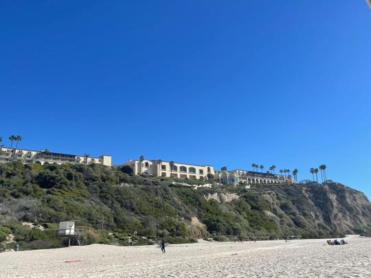
Crystal Cove State Park
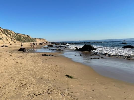
Walking along the Crystal Cove “trail” (on the beach)
Crystal Cove State Park is along the coast in Orange County, right next to Laguna Beach. We spent one night camping here and think it’s a really gorgeous place to stay the night. We wouldn’t necessarily go out of our way for this state park if not for the camping; there are plenty of other places in SoCal that you can get beautiful ocean views that aren’t paywalled behind a $15 state park fee.
Before setting up camp, we spent an afternoon hiking the popular Moro Canyon trail (4 mile version) and some of the 2.5 mile out-and-back (total 5 miles) Crystal Cove Trail, which entails a few minutes on coastal cliffs and is then mostly walking on the beach. They were good, but perhaps overhyped (and VERY hot and sunny on a February afternoon!).
CAMPING
Our campsite at sunrise
We snagged a camping spot at Moro Canyon Campground, which looks like a beautifully manicured parking lot overlooking the Pacific Ocean. Almost all of the spots were taken by RVs. The rows of campsites are tiered so that even the ones further back from the coast have lovely views of the water.
Pros of this campground:
+ The ocean views! The sunset, in particular, was spectacular.
+ The campground felt very clean, including the restrooms, which were single-unit restrooms rather than shared facilities with stalls. There were also coin-operated showers
+ The weather was nice for tent camping – the low was only about 50 degrees, and this was in the first weekend of February
+ The campground is located right by the start of the Moro Canyon trail, and there is also a path that allows access to the beach (we didn’t check it out)
+ It is just a few minutes’ drive from Laguna Beach, so there is a Trader Joes literally 2 minutes’ drive away and you can easily access tons of food options if you would like
+ Our campsite cost about $45 for the night, and if you have a camping reservation you don’t have to pay the $15 day pass for the state park between 3pm on the day your reservation begins and 12pm on the day it ends; this could save up to $30 in state park fees over the 2 days. (Note that we arrived early, around 12pm, and a kindly park ranger told us to check in at our campsite early to get our parking pass rather than pay the $15 day use fee, but the rangers at the campground check-in gave us a hard time about this. Whether or not they will be flexible seems like luck of the draw based on which ranger is there).
Sunset from the campground
(Fairly Minor) Cons of the campground:
- It is a very urban campground, located right off the Pacific Coast Highway. This means you can hear highway noise, like cars whooshing by, throughout the night from your tent (not sure how this would be in an RV). It reminded us a bit of living in Manhattan! This wasn’t really an issue for me, but perhaps would be difficult for someone who is sound sensitive. And in the quiet moments, you could also hear the lovely sounds of waves crashing on the beach.
- It is very gravelly and pebbly so we couldn’t put down tent stakes (and stakes are expressly prohibited by the campground). At some points it was somewhat windy and our tent was blowing around very noisily during the night; we were worried it might blow away if we didn’t have one person in it at all times. It probably would have also been somewhat uncomfortable to sleep on all the pebbles if we hadn’t had our yoga mats with us.
- We had site 32 and it was quite a bit of a walk from the restroom; if you anticipate needing to use a restroom at night we recommend trying to find a campsite closer to the restrooms.
Note: The park also has some primitive campgrounds that you can hike to, that are probably more secluded/away from the road than the one we stayed at.
View of the campground from the Moro Canyon trail
HIKING
1. Moro Canyon Trail: There are several variations of this hike; we followed the shorter path helpfully laid out by this blog post. The first ~2 miles were almost entirely uphill and a good workout but lacking in views; we’d rate this part of the trail moderate. The second half of the hike is not strenuous and is where you get iconic views of Laguna Beach. Of note, there is a pretty steep descent right at the end of the hike and I was glad to have a trekking pole for it. We would recommend doing this hike in the morning or evening to avoid the beating sun at mid-day. Overall, we’d say the hike is decent, but the views don’t rival those of the (free) cliffside walks we enjoyed at Rancho Palos Verdes (just south of LA) or hikes in the hills just north of Malibu.
View of Laguna Beach from the Moro Canyon trail
Parking: If you can, park at the Lower Moro Parking Lot, as the trailhead starts right there. The park rangers who checked us in for our campsite a bit earlier than the formal 3pm check-in time were on a bit of a power trip and didn’t allow us to park here (“campers who check in early aren’t allowed to park in this lot,” apparently, although plenty of non-campers were parked there), so we parked at the Upper Moro Parking Lot and walked 0.3-0.4 miles on a decent incline each way to get to the start of the trail. Both parking lots have the same $15 day use fee. You can pay the Upper Moro Parking Lot fee via a pay station next to the Visitor Center, which is located right in the lot. We saw rangers checking parked cars for payment.
2. Crystal Cove Trail (2.5 miles each way): We started at the beginning of the trail, which has about 10 minutes’ walking on a paved path and then a steep descent down to the beach that is part of the state park. (Note: It seems like you can choose to park elsewhere and pick up the trail at other points). It was pretty walking along the beach (you might want flip flops for this part); we only walked until we reached the park’s “Historic District” which includes little homes available for rental, places that seem to rent out gear for water activities, and the Beachcomber Café. We think the café would be a great little stop for a drink or appetizer; it has lovely outdoor seating overlooking the water and wrapping around the side of the restaurant. There are also public restrooms open to anyone, just behind the café (though I can’t say they were the cleanest). Although we turned back here, it seemed like the trail continued on.
Walking along the beach
Parking: We parked at the parking lot just off Reef Drive Road, which is where the trail starts. The cost is $15, included in the same day use fee that covers parking for the Moro Canyon hike or any other parts of the state park, including camping.
FOOD
Inside Crystal Cove State Park there is the Beachcomber Café (limited vegetarian options & overpriced) and a Shake Shack(!). There is also a Trader Joe’s very closeby. We snagged some basic but tasty vegan tacos and a vegan mushroom-and-tofu bowl at Taco Loco, which was a ~10 minute drive from our campground, in Laguna Beach. For more info on Laguna Beach, check out our next blog post on the area!
0 notes
Text
Confira todas as dicas para conhecer as principais atrações do Sequoia National Park, um parque incrível famoso por suas sequoias gigantes no coração do estado da Califórnia. Dicas de atrações, hospedagem, alimentação e muito mais!
ÍNDICE: CONFIRA O QUE ENCONTRAR NESTE POST
O SEQUOIA NATIONAL PARK
COMO CHEGAR AO SEQUOIA NATIONAL PARK
SERVIÇOS DE SHUTTLE NO SEQUOIA PARK
QUANDO VISITAR O SEQUOIA NATIONAL PARK
O QUE VISITAR NO SEQUOIA NATIONAL PARK
1. CENTROS DE VISITANTES E MUSEUS
2. ATRAÇÕES AO LONGO DA GENERALS HIGHWAY
3. CRYSTAL CAVE
ONDE COMER NO SEQUOIA NATIONAL PARK
ONDE SE HOSPEDAR NO SEQUOIA NATIONAL PARK
SUGESTÃO: ROTEIRO VIAJONÁRIOS
INFORMAÇÕES IMPORTANTES
O SEQUOIA NATIONAL PARK
Fundado em 1890, o Sequoia National Park um parque localizado ao sul de Sierra Nevada, no centro do estado da Califórnia, próximo às cidades de Visalia e Three Rivers. O parque é o antigo mais antigo dos EUA e abrange uma área de mais de 1,6 mil km² e inclui o Mount Whitney, uma montanha que fica a 4.421 metros acima do nível do mar. O Sequoia National Park é integrado fisicamente a um outro parque nacional, o Kings Canyon National Park. A UNESCO designou as áreas como Reserva da Biosfera Sequoia-Kings Canyon em 1976.
A beleza do Sequoia National Park
O parque é notável por suas sequóias gigantes, incluindo a árvore General Sherman, a maior árvore da Terra em volume. A árvore General Sherman cresce na Giant Forest (Floresta Gigante), que contém cinco das dez maiores árvores do mundo. O parque é cortado pela rodovia General Highway, levando os visitantes do Sequoia National Park ao Kings Canyon National Park, lar da árvore General Grant, entre outras sequoias gigantes. Uma curiosidade é que além de altíssimas, as sequoias podem viver mais de 3,5 mil anos! A maior parte dos visitantes entra pelo parque através de sua entrada sul, perto da cidade de Three Rivers e da Ash Mountain. A região tem uma flora e fauna vasta, incluindo muitas espécies de vida selvagem como lince, raposas, esquilos, cascavéis, veados, coiotes, texugos, carneiros, onças, pica-paus, tartarugas, corujas, gambás, castores, sapos, ratos e até mesmo ursos negros.
Floresta de sequoias
UM POUCO DE HISTÓRIA…
No passado, a área que agora conhecemos como o Sequoia National Park foi o primeiro lar da tribo de nativos americanos Monachee, que residia principalmente perto do Rio Kaweah, na região de Foothills, embora existam evidências de algumas habitações na Giant Forest. Quando os primeiros colonizadores europeus chegaram à região, a varíola já havia se espalhado para a região, dizimando populações nativas americanas. O primeiro colono europeu a se instalar na área foi Hale Tharp, que construiu uma casa com um tronco de sequoia gigante caído na Giant Forest ao lado de Log Meadow.
Tunnel Log
Tharp respeitava a grandeza da floresta e liderou as primeiras batalhas contra o corte na área, embora de forma limitada. O serviço florestal americano incorporou a Giant Forest ao Sequoia National Park em 1890, cessando todas as operações de corte de madeira. O parque expandiu ao longo das décadas, resistindo, inclusive, às tentativas da Walt Disney Corporation de comprar um antigo local de mineração para instalar uma estação de esqui. Este local, conhecido como Mineral King foi anexado ao parque posteriormente. Mineral King é o local desenvolvido com maior elevação dentro do parque e um destino popular para mochileiros.
IMPORTANTE: SEQUOIA TUNNEL NÃO EXISTE MAIS
A “Pioneer Cabin Tree” (também conhecida como “Tunnel Tree”) era uma antiga árvore, onde foi escavado um túnel há mais de um século. Esse túnel ficou conhecido como Sequoia Tunnel. No passado, cavalos, automóveis e pedestres eram autorizados a passar por lá. Devido a uma tempestade de inverno e inundações em janeiro de 2017, ela caiu e quebrou no impacto com o solo. Ela tinha mais de mil anos de idade e media 10 metros de diâmetro.
COMO CHEGAR AO SEQUOIA NATIONAL PARK
O Sequoia National Park fica localizado a cerca de 430 km de ao sul de San Francisco e 330 km ao norte de Los Angeles. Há duas estradas que podem ser utilizadas para chegar até o parque. A Highway 180, a partir da cidade de Fresco, que leva para o leste até a entrada via o Kings Canyon National Park e a Highway 198, passando pela cidade de Visalia, leva do leste ao Sequoia National Park via cidade de Three Rivers. Dentro dos parques, a rodovia 198 se torna a Generals Highway, que liga 198 a 180. No inverno, a Generals Highway geralmente fecha. Vale lembrar que a maior parque do parque não é acessível através de carro, pois nenhuma estrada atravessa a Sierra Nevada. Cerca de 84% do complexo Sequoia-Kings Canyon são considerados selvagem, podendo ser acessados somente a pé ou a cavalo.
Entrando no Sequoia National Park
DICA! Quem não quiser dirigir, pode contratar um tour privado com um guia especializado que levará você pelos principais pontos de interesse do parque.
SERVIÇOS DE SHUTTLE NO SEQUOIA PARK
Durante o verão (de final de maio a início de setembro) há serviços de ônibus disponíveis. Há um ônibus pago (US$ 20, linha azul no mapa abaixo) que passa pelas cidades vizinhas de Visalia e Three Rivers e terminando no Giant Forest Museum, já dentro do parque. Há também shuttles gratuitos que passam pelos campings Lodgepole, Wuksachi e Dorst Creek, através das linhas verde, cinza, roxa, laranja, detalhadas abaixo.
Mapa dos shuttle. Figura: site oficial
[icon name=”bus” class=”” unprefixed_class=””] Green Route 1: Giant Forest
Parte diariamente a cada meia hora às 8h e a cada 15 minutos de 9h às 18h. As paradas incluem: Lodgepole, General Sherman Tree Main Trail and Parking, General Sherman Tree Accessible Trail, e Giant Forest Museum.
[icon name=”bus” class=”” unprefixed_class=””] Gray Route 2: Moro Rock / Crescent Meadow
Opera nos fins de semana saindo do Giant Forest Museum às 8h e 8h45 e, a partir de 9h até 18h a cada 10 minutos. Durante os dias de semana, ele parte do Giant Forest Museum às 8h e 8h45 e, depois, a cada 20 minutos entre 9h e 18h. A estrada Moro Rock-Crescent Meadow Road fica fechada para veículos privados durante os fins de semana e feriados. As paradas incluem: Giant Forest Museum, Auto Log (fins de semana e feriados), Moro Rock, Tunnel Log (fins de semana e feriados) e Crescent Meadow.
Os pontos têm informações sobre horários e mapas das linhas de shuttle
[icon name=”bus” class=”” unprefixed_class=””] Purple Route 3: Lodgepole / Wuksachi
Os shuttles partem a cada 20 minutos entre 8h e 18h e param em Lodgepole Visitor Center and Campground, Wuksachi Lodge and Restaurant e Dorst Campground.
[icon name=”bus” class=”” unprefixed_class=””] Orange Route 4: General Sherman Tree Trails
Ônibus gratuitos partem a cada 15 minutos entre 9h e 18h, conectando a Wolverton Picnic Area and Traihead até a Sherman Tree. Os pontos de parada são General Sherman Tree Main Trail and Parking, General Sherman Tree Accessible Trail e Wolverton Trailhead and Picnic Area.
Alguns dos shuttles que circulam dentro do parque
QUANDO VISITAR O SEQUOIA NATIONAL PARK
O parque fica aberto 24 horas por dia, 365 dias por ano. No entanto, algumas condições climáticas pode prejudicar muito a sua visita, uma vez que algumas estradas que levam ao parque podem estar fechadas. As temperaturas no Sequoia National Park variam muito de região para região e o tempo pode mudar rapidamente. Confira as principais características de cada uma das estações.
PRIMAVERA: A primavera compreende os meses de abril a meados de junho. Ainda pode nevar nesta época do ano, dependendo se o inverno foi rigoroso. As tempestades de neve no fim da primavera são comuns, e é uma boa ideia verificar as previsões do tempo antes de sua visita. À medida em que a neve vai derretendo, os rios e riachos vão ficando mais cheios e perigosos e as flores silvestres vão surgindo.
VERÃO: O verão no hemisfério norte inclui os meses de julho, agosto e setembro. Este é a época quando a maior parte dos visitantes vai ao parque porque todas as áreas e atrações estão abertas em horário extendido. As temperaturas são agradáveis em meio às grandes áreas verdes.
Paisagem durante o verão
OUTONO: A partir de setembro, as temperaturas começam a cair durante à noite, embora os dias possam ainda estar quentes. O tempo é mais instável, intercalando dias quentes e dias chuvosos. Pode nevar um pouco no final de outubro e algumas das instalações do parque apresentam horários reduzidos ou ficam fechadas.
INVERNO: Os dias de inverno são frios e com neve. No entanto, é difícil prever a quantidade de neve durante o período, podendo nevar muito pouco ou até ter algumas tempestades de neve. Talvez seja necessário usar correntes nos pneus para andar pelas estradas. Áreas como Mineral King fecham durante a temporada de neve.
O QUE VISITAR NO SEQUOIA NATIONAL PARK
Há uma infinidade de coisas para fazer dentro do Sequoia National Park. Além de atividades ao ar livre, há centros de visitantes, estações de guardas florestais e um museu que oferecem oportunidades para explorar a natureza e a história do parque, assistir a filmes informativos e obter informações sobre planejamento de viagens. No mapa interativo abaixo, você vai encontrar, em azul, as principais atrações do Sequoia National Park e em verde, do Kings Canyon National Park, que estão descritas no post dedicado ao parque: Califórnia: Kings Canyon Park e o canyon mais profundo dos EUA. As opções de hospedagem estão em preto, locais para comer estão em vermelho, centro de visitantes e museus em laranja e cavernas em roxo.
1. CENTROS DE VISITANTES E MUSEUS
Existem 4 locais com exposições e informações aos visitantes dentro do Sequoia National Park. Confira mais informações sobre cada um deles abaixo.
>> FOOTHILLS VISITOR CENTER
Geralmente, esta é a primeira parada para quem visita o Sequoia National Park. O Foothills Visitor Center oferece informações sobre planejamento de passeios no parque, caminhadas, exposições, primeiros socorros, além de mapas, livros e presentes relacionados à natureza. A sala de exposição gratuita do centro oferece exposições sobre a ecologia dos montes e a história humana. Programas gratuitos liderados por guardas florestais estão disponíveis durante o verão a partir deste centro de visitantes. Durante os meses de verão, os ingressos para o Crystal Cave podem ser comprados aqui. No local também ficam banheiros públicos, mas não há nenhum lugar para comprar um café ou comer alguma coisa. Aberto o ano todo diariamente de 8h às 16h30 de meados de março a final de novembro e de 9h às 16h de dezembro a meados de março.
#gallery-0-7 { margin: auto; } #gallery-0-7 .gallery-item { float: left; margin-top: 10px; text-align: center; width: 33%; } #gallery-0-7 img { border: 2px solid #cfcfcf; } #gallery-0-7 .gallery-caption { margin-left: 0; } /* see gallery_shortcode() in wp-includes/media.php */
Entrada do Foothill Visitor Center
Exposições do centro de visitantes
Exposições contam a história do parque
Exposições do centro de visitantes
Exposições do centro de visitantes
Guarda-florestal de pelúcia à venda na lojinha local
>> GIANT FOREST MUSEUM
Este museu fornece uma introdução básica às principais características da Giant Forest, incluindo suas sequoias gigantescas, prados e história humana. O museu foi projetado para servir como ponto de partida para visitas ao bosque, oferecendo uma oportunidade de aprender a história das sequoias gigantes e da Giant Forest. Há exposições e a exibição de um filme em uma pequena sala.
Fachada do Giant Forest Museum
Entrando no museu
Comparação entre os tamanhos
Em frente ao museu, fica a Sentinel, uma enorme sequoia de 78,5 metros de altura e um tronco com uma circunferência de mais de 24 metros. Para apoiar o museu, o edifício Beetle Rock foi mantido para servir como sala de aula e auditório para fins educacionais. Aberto o ano todo, diariamente de 9h às 16h30 / de 10h às 16h30 de janeiro a meados de março.
A imensa Sentinel fica em frente ao museu
>> LODGEPOLE VISITOR CENTER
Este centro de visitantes tem como objetivo fornecer informações, ser um espaço para exposições, e um local onde os visitantes podem encontrar livros e mapas que podem ajudar a planejar a visita ao parque. Alguns programs gratuitos liderados por guardas florestais são oferecidos a partir deste centro de visitantes. Lodgepole Village oferece serviço de alimentação, mercado, chuveiros, lavanderia e correios. O centro abre na segunda sexta-feira de maio e fecha na primeira sexta-feira de outubro diariamente de 8h às 16h30 – horários podem variar, veja aqui
Lodgepole Visitor Center. Foto: site oficial
>> MINERAL KING RANGER STATION
Esta estação de guardas florestais fica afastada do restante das atrações do parque, localizada em uma floresta de coníferas mistas a uma seleção de 2.320 metros. Ela abriga algumas exposições sobre a história humana e natural de Mineral King. Livros, mapas e itens educacionais para venda. Aberto geralmente do final de semana do feriado de Memorial Day até o fim de semana do feriado de Labor Day, diariamente de 8h às 16h / fechado de final de setembro a final de maio
2. ATRAÇÕES AO LONGO DA GENERALS HIGHWAY
>> TUNNEL ROCK
A cerca de 2,5 km ao norte do Foothills Visitor Center, Tunnel Rock (túnel de pedra) é um túnel escavado em uma rocha de granito ao lado da rodovia Generals Highway. Antes de a estrada ser ampliada em 1997, os carros passavam embaixo dessa passagem estreita. Atualmente, esta passagem está fechada para carros, mas é possível conhecer o local explorando-o a pé.
Tunnel Rock visto da General Highway
Atualmente, não passam mais automóveis por debaixo da pedra.
>> HOSPITAL ROCK
Hospital Rock é uma grande rocha de quartzo localizada na saída da Generals Highway. No passado, o local já foi o lar de 500 nativos americanos da tribo Potwisha. Evidências arqueológicas mostram que assentamentos foram feito na área antes de 1350 e até hoje é possível encontrar petróglifos. Os ameríndios usavam esse lugar principalmente nos meses de inverno. Atualmente, Hospital Rock é um sítio arqueológico público. Deixe o carro estacionado área onde há mesas para piquenique e atravesse a estrada a pé para chegar até Hospital Rock.
Uma pequena escadaria leva até Hospital Rock
Detalhes dos petróglifos
>> AMPHITHEATER POINT
Este é um mirante na estrada que oferece uma excelente vista lateral do Moro Rock, juntamente com vistas desde o sopé das montanhas até os picos alpinos. Vale a pena parar um pouquinho para admirar as vistas lindas se o dia estiver ensolarado.
Vista de Moro Rock a partir do Amphitheater Point
>> MORO ROCK
Moro Rock é uma formação rochosa de cúpula de granito com mais de 2 mil metros de altura. Ele está localizado no centro do parque, na cabeceira do Moro Creek, entre a Giant Forest e o Crescent Meadow. Uma escada de 400 degraus foi construída na década de 1930 para que os visitantes possam caminhar até o topo. A estrada para Moro Rock fica fechada no inverno e os visitantes precisam andar por mais de 3 km para chegar ao mirante. Desde 2007, nos fins de semana do verão, a estrada se fecha para veículos particulares e ônibus gratuitos são a única maneira de chegar a Moro Rock.
Prepare-se para subir muitos degraus
Trilha que leva até o topo de Moro Rock
Vista panorâmica do parque
>> TUNNEL LOG
Tunnel Log é um túnel construído através de uma sequoia caída ao longo da Crescent Meadow Road na Giant Forest. Ao que se sabe, a sequoia caiu por causas naturais em 1937. Quando caiu, ela tinha cerca de 83,8 metros de altura e 6,4 metros de diâmetro na base. Acredita-se que, na época, a idade da sequoia poderia ultrapassar os 2 mil anos. O túnel, que permanece em uso hoje, possui cerca de 5,2 metros de largura por 2,4 metros de altura.
No túnel aberto na sequoia
É possível ainda ver a árvore caída no local
O Paulo resolveu subir na sequoia
>> CRESCENT MEADOW
Crescent Meadow é um local que abriga uma grande área de piquenique e uma trilha em loop por um grande prado em forma de crescente localizado na borda da área de piquenique. Para chegar ao local é preciso pegar uma trilha (sem nome) ou uma mais longa, chamada Tharp’s Log, onde fica o tronco de uma sequoia gigante usado como abrigo pelos primeiros residentes que desbravaram o local. Quando vistamos o local, estava acontecendo uma cerimônia de casamento no local (com vestido de noiva, salto e tudo mais!)
Placa indica a trilha para Crescent Meadow
Ponte durante a trilha para Crescent Meadow
Crescent Meadow
Trata-se de um prado cercado por árvores altíssimas
>> GENERAL SHERMAN TREE
A General Sherman Tree fica no meio do Giant Forest Grove, uma floresta de sequoias gigantes, onde é possível encontrar um tronco imenso em que é possível passar por dentro, partes cortadas de uma sequoia para ter uma ideia do tamanho da circunferência da árvore, totens informativos, entre muitas outras atrações.
#gallery-0-8 { margin: auto; } #gallery-0-8 .gallery-item { float: left; margin-top: 10px; text-align: center; width: 33%; } #gallery-0-8 img { border: 2px solid #cfcfcf; } #gallery-0-8 .gallery-caption { margin-left: 0; } /* see gallery_shortcode() in wp-includes/media.php */
Começando o passeio pela floresta de sequoais
Árvores imensas!
Caminhando pela floresta
Todo o caminho é asfaltado
Uma caminhada por entre as gigantes
Uma sequoia caída
Uma ampla variedade de árvores
Árvores enormes
Várias sequoias estão presentes
Olha só o tamanho da circunferência!
Sequoias gêmeas
Vista do topo das sequoias gêmeas
A General Sherman é uma sequoia gigante que, em volume, é o maior tronco vivo conhecido no planeta. A árvore General Sherman recebeu, em 1879, este nome em homenagem ao general William Tecumseh Sherman, da Guerra Civil Americana. Com uma altura de 83,8 metros, um diâmetro de 31,1 metros no solo, pesando cerca de 1.300 toneladas e uma idade estimada entre 2.300 e 2.700 anos, a General Sherman é uma das mais altas, mais largas e mais longas de todas as árvores do planeta.
Em frente a General Sherman Tree
A General Sherman Tree é grandiosa
Nós e as gigantes!
Totem informativo sobre a General Sherman Tree
Trilha que leva para uma área traseira da árvore
General Sherman Tree vista de longe
É possível chegar ao local através de duas trilhas. O estacionamento para a Main Trail (trilha principal) fica na Wolverton Road, entre a Sherman Tree e Lodgepole. A trilha possui cerca de 800 metros até a árvore, passando pela Giant Forest. Exposições ao longo da trilha explicam a história natural das sequóias gigantes. A caminhada de volta é uma bela subida. Outra opção, se você fazer a caminhada inicial em declive, é estacionar na Main Trail, caminhar até a árvore General Sherman, depois continuar até a parada do ônibus ao longo da Generals Highway. Um serviço de shuttle pode levar você de volta à sua área de estacionamento, evitando fazer toda a subida a pé.
Uma das trilhas que liga o estacionamento à floresta de sequoias
Durante o inverno, como muita neve cai na região, a principal área de estacionamento da Wolverton Road fecha e a área de estacionamento acessível na Generals Highway fica disponível para todos. A trilha de lá para a árvore não é íngreme, mas pode ficar com muita neve.
3. CRYSTAL CAVE
Crystal Cave é uma das mais de 240 cavernas conhecidas em mármore dentro do Sequoia National Park. Ela fica na área da Giant Forest entre a entrada da Ash Mountain e o Giant Forest Museum. A caverna tem uma temperatura de 9ºC e é acessível somente mediante a tours guiados. Os ingressos podem ser comprados online (recomendado em alta temporada) ou nos centros de visitante Foothills Visitor Center ou Lodgepole Visitor Center. É preciso fazer uma trilha para chegar até o local one o passeio tem início. A trilha é muito bonita, com cachoeiras no meio do caminho. Porém, a volta do passeio é uma subida bem íngrime e cansativa. Vamos escrever um post dedicado à nossa visita a Crystal Cave com todos os detalhes de como é o passeio.
Endereço: Sequoia National Park, Three Rivers, CA 93271
Horários: tours disponíveis de final de maio a final de setembro
Entrada: somente mediante tours guiados – compre online neste link
Tours disponíveis:
Discovery Tour: 1h30 para maiores de 13 anos / US$ 25
Family Caver Tour: 1h30 / US$ 50
Family Tour: 50 minutos, para todas as idades / US$ 16
Family Tour (maiores de 13 anos): 50 minutos / US$ 16
Thirteen and Older Tour: 50 minutos para maiores de 13 anos / US$ 16
Life on Other Worlds: 270 minutos / US$ 17
Wild Cave Tour: de 4h a 6h de duração, maiores de 10 anos e boas condições físicas / US$ 140
Uma das cachoeiras na trilha para a caverna
Placa na entrada da Crystal Cave
Área interna da Crystal Cave
ONDE COMER NO SEQUOIA NATIONAL PARK
Nossa recomendação é que você esteja preparado para fazer um piquenique no parque. São poucas as opções de lugares para comer e ficam longe. No verão, como é necessário deixar o carro em um estacionamento e ficar andando pelo parque com os ônibus internos, você não vai querer perder tempo se deslocando para chegar até um local para comer. Não se esqueça de que é lei não deixar a comida no carro e armazenar nos grandes armários marrons a prova de ursos, que são compartilhados. De qualquer forma, confira algumas opções de restaurantes dentro do Sequoia National Park e nos seus arredores.
DENTRO DO SEQUOIA NATIONAL PARK
The Peaks Restaurant at Wuksachi Lodge
Lodgepole Deli, Market, and Snack Bar (funciona de meados de abril a meados de outubro)
Montecito-Sequoia Lodge
Stony Creek Lodge (aberto entre maio e outubro)
Silver City Resort (aberto de final de maio a meados de outubro)
DENTRO DO KINGS CANYON PARK
Grant Grove Restaurant
Cedar Grove Snack Bar
RESTAURANTES FORA DOS PARQUES
Casa Mendoza Mexican Restaurant
Gateway Restaurant & Lodge
Ol’ Buckaroo
Pizza Factory
River View Restaurant & Lounge
Sequoia Cider Mill
Sierra Subs & Salads
Silver City Mountain Resort
ONDE SE HOSPEDAR NO SEQUOIA NATIONAL PARK
Existem cinco áreas principais desses parques onde são oferecidos camping, hospedagem e outros serviços. Os serviços durante todo o ano são fornecidos em Grant Grove, Foothills e Giant Forest & Lodgepole. As áreas do Mineral King e Cedar Grove ficam abertas da primavera ao outono. Veja todas as informações sobre camping neste link e, abaixo, sobre os hotéis disponíveis:
DENTRO DO SEQUOIA NATIONAL PARK
Wuksachi Lodge
Pear Lake Winter Hut (funciona entre dezembro e abril)
Stony Creek Lodge
Montecito Sequoia Lodge (nós nos hospedamos)
DENTRO DO KINGS CANYON PARK
Cedar Grove Lodge
John Muir Lodge
Grant Grove Cabins
FORA DOS PARQUES
The Gateway Restaurant & Lodge
The River Inn (nós nos hospedamos)
Comfort Inn & Suites Sequoia Kings Canyon
Western Holiday Lodge Three Rivers
Um dos quartos do Montecito Sequoia. Foto: divulgação
RESERVE AGORA seu hotel e economize até 50%. Leitores do Viajonários estão com um SUPER DESCONTO! E o melhor, com CANCELAMENTO GRÁTIS*!
Booking.com
(function(d, sc, u) { var s = d.createElement(sc), p = d.getElementsByTagName(sc)[0]; s.type = 'text/javascript'; s.async = true; s.src = u + '?v=' + (+new Date()); p.parentNode.insertBefore(s,p); })(document, 'script', '//aff.bstatic.com/static/affiliate_base/js/flexiproduct.js');
*confira os hotéis com cancelamento grátis no site
SUGESTÃO: ROTEIRO VIAJONÁRIOS
Agora que já falamos sobre todas as atrações do parque e as opções de hospedagem e alimentação, falaremos um pouquinho sobre como montamos nosso roteiro para conhecer o Sequoia National Park. Morando na Califórnia, nós aproveitamos para conhecer o local em um final de semana ensolarado de agosto. Na época em que visitamos o local, morávamos a pouco menos de 400 km do parque.
>> SEXTA-FEIRA: PASSAR A NOITE EM THREE RIVERS, ENTRADA DO PARQUE
Saímos em uma sexta-feira no final da tarde e nos hospedamos no The River Inn, um hotel bem simples de apenas 2 estrelas na cidade de Three Rivers, porta de entrada para o parque. O hotel não era a melhor opção da região, mas era a que estava mais em conta e ainda tinha vagas. O quarto tinha frigobar, cafeteira e microondas, o que ajudou muito a preparamos nosso café da manhã, já que não é servido no hotel. Nós já levamos de casa pão, bolo, uma torta de palmito, castanhas e umas bolachinhas. Levamos também um cooler com algumas coisas para passar no pão de manhã e frutas picadas. Recomendamos muito que você já leve umas guloseimas para fazer um piquenique. Como falamos anteriormente, nem sempre vai ser fácil você se deslocar para um restaurante dentro do parque. Previna-se e vá preparado.
>> SÁBADO: SEQUOIA NATIONAL PARK + CRYSTAL CAVE
Acordamos cedinho para entrar no parque sem aquela muvuca toda de visitantes. Como já tínhamos comprado previamente o passe anual para todos os parques nacionais dos Estados Unidos, não precisamos comprar o ingresso na hora, mas se você não tem, basta pagar o valor do ticket na entrada do parque.
Entrada do Sequoia National Park
Nós já havíamos também reservado ingresso para fazer o tour guiado pela Crystal Cave ainda no período da manhã. Nós não fizemos trilhas longas e utilizamos o shuttle gratuito no parque para conhecer as atrações localizadas nas linhas cinza e laranja. Tenha sempre com você o mapa do shuttle (tem no começo deste post) para saber qual você deve pegar dependendo da atração que deseja conhecer. Nós só conseguimos estacionar em Wolverton Picnic Area e tivemos que ir pegando os shuttles para nos deslocarmos pelo parque.
Curtindo as vistas lindas do Sequoia National Park
Terminamos o dia jantando no Montecito Sequoia Lodge, hotel localizado dentro do parque onde nos hospedamos da noite de sábado para domingo. O parque tem um plano de refeições inclusa, então jantamos e tomamos o café da manhã lá que já estavam inclusos na tarifa.
Montecito Sequoia Lodge durante a noite
>> DOMINGO: KINGS CANYON NATIONAL PARK
Depois de tomar café da manhã, paramos em dois mirantes: o Kings Canyon Overlook e o Redwood Mountain Overlook.
Kings Canyon Overlook
Saindo de lá, continuamos na estrada para visitar as atrações do Kings Canyon National Park, que fica coladinho ao Sequoia. O roteiro completo para o parque pode ser encontrado no post: Califórnia: Kings Canyon Park e o canyon mais profundo dos EUA. Temos que confessar que gostamos bem mais deste último parque. Foi uma surpresa ótima porque não estávamos com muitas expectativas e fomos surpreendidos muito positivamente. O parque estava bem mais tranquilo, o Centro de Visitantes é novinho e bem organizado, as vistas são incríveis e há uma variedade enorme de locais bacanas para se conhecer: floresta de sequoias, um canyon enorme, a estrada que margeia o Rio Kings, paredões de granito, uma cachoeira bem bacana e muito mais! Fizemos um piquenique do lado do rio e relaxamos ao som da forte correnteza. O dia acabou com o nosso retorno para nossa casa no Vale do Silício.
Zumwald Meadows, uma das áreas mais lindas do parque
INFORMAÇÕES IMPORTANTES
Sequoia National Park
Endereço: CA 93271, Estados Unidos
Horários: o parque funciona 24 horas por dia o ano todo, o horário dos centros de visitantes e museus varia
Foothills Visitor Center: o ano todo diariamente de 8h às 16h30 de meados de março a final de novembro e de 9h às 16h de dezembro a meados de março
Giant Forest Museum: aberto o ano todo, diariamente de 9h às 16h30 / de 10h às 16h30 de janeiro a meados de março
Lodgepole Visitor Center: abre na segunda sexta-feira de maio e fecha na primeira sexta-feira de outubro diariamente de 8h às 16h30 – horários podem variar, veja aqui
Mineral King Ranger Station: aberto geralmente do final de semana do feriado de Memorial Day até o fim de semana do feriado de Labor Day, diariamente de 8h às 16h / fechado de final de setembro a final de maio
Entrada: US$ 35 válido para até 7 dias, inclui a entrada de 1 veículo não comercial (veja mais detalhes neste link) no Sequoia National Park e no Kings Canyon National Park | US$ 80 passe anual para todos os parques nacionais dos Estados Unidos – leia mais aqui
Guarde estas dicas no Pinterest!
Leia mais sobre parques americanos:
O incrível Yosemite Park na Califórnia
Califórnia: Death Valley, o Vale da Morte
Lassen Volcanic Park: O Parque dos Vulcões na Califórnia
O belo Zion Park no estado de Utah
Roteiro para visitar o Grand Canyon (South Rim)
O cinematográfico Monument Valley entre Arizona e Utah
Confira todas as dicas para conhecer as principais atrações do Sequoia National Park, um parque incrível famoso por suas sequoias gigantes no coração do estado da Califórnia. #california #sequoias #sequoianationalpark
0 notes
Photo
first backpacking trip so far so good (at El Moro Campgrounds (Crystal Cove State Park)) https://www.instagram.com/p/BpvWq6YBQt1/?utm_source=ig_tumblr_share&igshid=5l89p9yma634
0 notes
Text
Saturday 11 August 2018
Moro Rock and General Sherman Tree
We have decided to try out the shuttle system today. After our potato cake breakfast we drive to Grant Village on a hunt for half and half (we ran out this morning) and to get to good cell reception so I can call Dad. The little market here has only milk and artificial creamer. O and I come up with a brilliant substitution. We will buy coffee chocolate chip ice cream. It will melt in our little fridge, but it might make really tasty coffee in the morning. That job done (sort of) I call Dad. It sounds like he has the broken air conditioner problem at home under control. The old one is temporarily patched up and a new one is on order.
Back at camp we pack our small daypack with water, guide book and maps and bring along binoculars and camera. A comfortable little shuttle arrives at the campground soon after we get to the shuttle stop. This shuttle takes us back to Lodgepole Village where we get ice cream for a lunch snack and then catch the next shuttle to the Forest Museum. From here we have a bit of a wait for the next bus to Moro Rock, one of the “must see” attractions at Sequoia. There is a long line and the first shuttle fills by the time we get to the front of the line. We are the first to board the next bus which fills again with the people behind us. O and I hear Spanish, German, Korean and French as we ride but very little English. Our busload arrives at Moro Rock, a small granite dome. In 1931 a stairway was carved into the granite and handrails were added where necessary. It's a steep but short climb up about 350 steps. The view from the top is impressive, even in the smoky haze. To the east is the spine of the Sierra Nevada. To the south we can see the winding road we drove up two days ago. Once we get our fill of the view, O and I descend. We can see rain clouds to the east and there are rumbles of thunder. An exposed rock dome is not a good place to be if there is lightning nearby.
At the base of Moro Rock we wait in another line for the bus back to the Forest Museum. Unfortunately, we are running out of time. The museum visit will have to wait for another day. From the museum we catch a shuttle to the Sherman Tree. A short paved walk leads to a view of the largest tree on earth. It is not the tallest tree, but in volume and mass it exceeds all others. This tree is 2200 years old! In a long winding line near the sign that says “General Sherman” people wait patiently, cameras in hand, for their photo op. The General is more popular than Santa! A ranger stands nearby to answer questions and maintain order.
From General Sherman it is back to Lodgepole Village where we finally find half and half. (We'll still try the ice cream in the morning.) Then we wait in yet another line to board the purple shuttle back to camp. My conclusion: the shuttles work, but if you really want to have hiking time, choose another means of transportation!
0 notes
Last Seen Blogs

c-1-rl-4-s
Sin título

add-things
AuADHD Problems

insane-clan
insane-clan

xoqapawugaw
Untitled

banks-house
BANKS.inc