#Geoscience & Environment news
Text
One in seven deepwater sharks and rays at risk of extinction - Technology Org
New Post has been published on https://thedigitalinsider.com/one-in-seven-deepwater-sharks-and-rays-at-risk-of-extinction-technology-org/
One in seven deepwater sharks and rays at risk of extinction - Technology Org
One in seven species of deepwater sharks and rays are threatened with extinction due to overfishing, according to a new eight-year study released today in the journal Science.
A shark – illustrative photo. Image credit: Pixabay (Free Pixabay license)
Specifically, the analysis found that sharks and rays are caught as incidental bycatch in fisheries targeting more commercially valuable species. However, they are kept due to the value of their oil and meat. This, partnered with a recent global expansion in the trade of shark liver oil, have resulted in steep population declines.
“About half of the world’s sharks are found below 200 metres, below where the sunlight reaches into the ocean,” says Nicholas Dulvy, Distinguished SFU Professor of Marine Biodiversity and Conservation.
“The first time they see sunlight is when they’re hauled onto the deck of a fishing boat.”
youtube
This new analysis by Dulvy assessed more than 500 species of sharks and rays and engaged more that 300 experts from around the world. It found that about 60 species are threatened with an elevated risk of extinction due to overfishing, according to the criteria of the International Union for Conservation of Nature (IUCN) Red List of Threatened Species.
“As the high seas and the coastal waters are becoming depleted in many countries of the world, we’re incentivizing fishers to fish offshore and it’s become technologically viable to fish up to a kilometre deep,” Dulvy says.
Deepwater sharks and rays are among the most sensitive marine vertebrates because of their long lifespans and low reproductive rates. They have life cycles more similar to marine mammals such as whales and the walrus, which were formerly exploited for their oils and are now highly protected.
“Many deepwater sharks and rays can only withstand very small amounts of fishing pressure,” says Dulvy. “Some species may take 30 years or more to mature, and possibly up to 150 years in the case of the Greenland Shark, and only produce 12 pups throughout their entire life.”
Sharks and rays maintain their buoyancy by having a fatty liver, but this fat is highly prized. It’s used widely in cosmetics, nutrient supplements and for medicines, like vaccines. There has also been an increase in skate fisheries to support demand for fermented skate, a traditional Korean delicacy.
“There’s been great success in regulating shark fin trade. Now we need to turn our attention to regulating the international trade in liver oil.”
In addition to regulating the international trade in shark liver oil, the study also endorses a global push to protect 30 per cent of the world’s oceans by 2030. Protecting 30 per cent of the deep ocean (200 to 2,000 metres) would provide 80 per cent of species partial protection across their range. A worldwide prohibition on fishing below 800 metres would provide 30 per cent vertical refuge for a third of threatened deepwater sharks and rays.
The Global Shark Trends Project is a collaboration of the Simon Fraser University, IUCN Shark Specialist Group, James Cook University, and the Georgia Aquarium, established with support from the Shark Conservation Fund.
Written by Jeff Hodson
Source: SFU
You can offer your link to a page which is relevant to the topic of this post.
#000#Analysis#attention#biodiversity#Biology news#Collaboration#Conservation#deep ocean#extinction#fat#fish#fisheries#fishing#Geoscience & Environment news#Global#Greenland#it#life#Link#list#marine#meat#nature#ocean#oceans#oil#One#overfishing#photo#population
1 note
·
View note
Photo
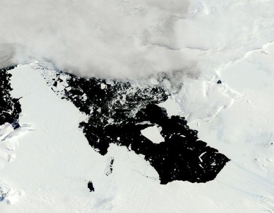
Pine Island Glacier collapse inevitable
This image was taken by the MODIS instrument on NASA’s Terra satellite on January 5th, 2014, and it shows an iceberg in Antarctica’s Pine Island Bay. The iceberg began as a crack in Pine Island Glacier last November and broke away as a piece the size of Singapore in early January.
The Pine Island Glacier is a major feature of West Antarctica. Western Antarctica is covered by an ice sheet. When snow falls on top of that ice sheet, it pushes older ice out towards the coast through a series of “ice streams”. The Pine Island glacier is one of these ice streams; about 20% of West Antarctica’s ice flows through its channel and you can even see streaks at the bottom-right of this image marking its flow direction.
The Pine Island glacier is also one of the least stable in Antarctica. Over the last 20 years it has shrunk rapidly, contributing several millimeters worth of sea level increase over that time. New research published in the journal Nature Geoscience suggests this is just the beginning, and over the next few decades a large portion of this glacier is going to collapse.
This type of ice stream typically starts on land and moves out to sea. It pushes ice out to sea, forming a shelf of ice floating offshore. Further up, there is a “grounding line” – the point at which the glacier goes from sitting on land to floating on the oceans. Above the grounding line the glacier is anchored to rocks at the base; below the grounding line the glacier is exposed to the waters of the ocean.
Much of the melting of this glacier over the last 20 years is due to the ice shelf shrinking. When warmer waters come up beneath the ice shelf, they cause ice to melt and to break away as icebergs, and as the ice shelf shrinks the glacier begins flowing faster as the sea ice helps hold the rest of the glacier in place.
But the Pine Island glacier is unique in an important way; its grounding line sits on an underwater ridge. The rocks that this glacier was hanging on to had another bay behind them where the waters got deeper. Water from the warming ocean couldn’t get into this bay because the glacier was grounded farther out to sea, but this setup created a precarious situation.
What would happen if the glacier lost its grounding point on this underwater ridge? The glacier would lose all of its support. The next possible grounding point is tens of kilometers farther up. If the glacier lost contact with this underwater ridge, the glacier would become extremely unstable.
New research just published in the journal Nature Geoscience says that is exactly what has happened. Based on radar surveys taken through the ice, the Pine Island Glacier has now lifted completely off this ridge. Warmer waters from the open ocean are now free to flow along the entire base of this glacier; it is no longer pinned in place and has crossed a point of no return.
Using models for how ice flows over topography, the scientists modeled the behavior of this glacier without the pinning point and project that it is in an irreversible retreat. The glacier will melt at the base weakening it and over time ice will break off until it retreats tens of kilometers to its next grounding point. The current structure of this glacier is going to collapse.
The Pine Island Glacier is already the largest contributor to sea level rise on the Antarctic Continent. Based on these models, the scientists project that over the next 20 years, it is likely that this glacier will contribute 3 to 5 times as much to sea level rise as it did during the last 20 years and possibly more.
The unsupported part of this glacier is going to die. It will retreat back to the new grounding line, dumping large amounts of water into the ocean and causing flow from the continental ice sheet to accelerate.
-JBB
Original article: http://www.nature.com/nclimate/journal/vaop/ncurrent/full/nclimate2094.html
Image credit: NASA/GSFC/Jeff Schmaltz/MODIS Land Rapid Response Team http://www.flickr.com/photos/gsfc/11949193796/
Read more: http://www.bbc.co.uk/news/science-environment-25729750 http://www.independent.co.uk/environment/climate-change/pine-island-glacier-melting-past-the-point-of-no-return-9059347.html http://www.reportingclimatescience.com/news-stories/article/pine-island-glacier-committed-to-irreversible-decline.html_ _
#Science#antarctica#pine island glacier#grounding line#climate change#global warming#the earth story#earth from space#satellite#ice
98 notes
·
View notes
Text
FEATURE: CESB’s concept 'Govergence' seen as key to good governance towards ending armed conflicts
#PHinfo: FEATURE: CESB’s concept 'Govergence' seen as key to good governance towards ending armed conflicts
Career Executive Service Officers (CESOs), Career Executive Service Eligibles (CESEs) and Career Service Executive Eligibles (CSEEs) attentively listen to a presentation during a CESB Leadership Conclave with the Theme: "Govergence: Cultivating Exemplary Service." (Photo courtesy of Mr. Ernesto Alcanzare, Yes For Peace - Bayanihan ng Bayan lead organizer)
The Whole of Nation approach to ending the armed conflicts being pursued by the National Task Force to End the Local Communist Armed Conflicts (NTF-ELCAC) is anchored on good governance and would entail direct people’s participation.
Given limited resources of the government, the NTF-ELCAC has focused on eight hundred (800) barangays liberated from the influence and clutches of the Communist Party of the Philippines-New People’s Army-National Democratic Front (CPP-NPA-NDF) to prove that the communist armed conflict can be ended through good governance.
Executive Order No. 70, which created the NTF-ELCAC is not a spur of the moment decision made by President Rodrigo Roa Duterte. It was a product of a painstaking and wholistic process that would need the sustained long-term action of the government and the people in addressing the roots of the insurgency.
Prior to the creation of the NTF-ELCAC, the Department of the Interior and Local Government (DILG) has initiated and is in the process of institutionalizing its Bottom-Up Planning and Budgeting program.
“AmBisyon Natin 2040 represents the collective long-term vision and aspirations of the Filipino people for themselves and for the country in the next 25 years,” the National Economic and Development Authority (NEDA) declared in AmBisyon Natin 2040, which was adopted as the country’s development road map in 2015.
“All sectors of society, whether public or private, should direct their efforts towards creating opportunities for Filipinos to enjoy a matatag, maginhawa at panatag na buhay.” the NEDA continued, “Government, in particular, must use its tools of fiscal, monetary and regulatory policies to steer the development path towards enabling Filipinos to attain their AmBisyon. This pertains to all dimensions of development: economic, human and physical capital, institutional, social and cultural.”
In 2017, "Govergence: Cultivating Exemplary Service" was the year-round theme of CES Leadership Conclave series conducted by the Career Executive Service Board (CESB).
“As the nation moves toward achieving lasting peace, redefining its national identity in a global environment and leading the ASEAN region towards cooperation, it is imperative for us to promote synergism within and beyond the CES Community on the premise that amidst diversity lie opportunities to harness unique individual and organizational talents and resources through partnership, collaboration and cooperation,” Maria Anthonette Velasco-Allones, then CESB Executive Director wrote in her letter-invitation for members of the CES: Career Executive Service Officers (CESOs); Career Executive Service Eligibles (CESEs); and Career Service Executive Eligibles (CSEEs).
Inspired by the concept Govergence, members of the SALDIWA 31 and I-GABAY 26, listed community-based programs that could empower the communities in giving flesh to the development thrusts of the DILG and NEDA, through the pro-active involvement and collective participation of the people in identifying, planning, budgeting, and implementing projects needed in their respective communities.
“We are all aware of the fact that there is no such thing as a one size fits all in development,” Ernesto Angeles Alcanzare, Organizer of Yes for Peace – Bayanihan ng Bayan said, “Thus, we listed all the programs and projects that came to mind.”
“We presented the list to the Sectoral Unification, Capability Building, Empowerment and Mobilization (SUCBEM) cluster of the NTF-ELCAC,” Alcanzare recalled. “Members of the cluster from different agencies added to the list as one of the steps in refining Yes for Peace.”
The SUCBEM cluster proposed the adoption and refinement of Yes for Peace – Bayanihan ng Bayan which was incorporated into the National Action Plan of the NTF ELCAC submitted by National Security Adviser Hermogenes C. Esperon, Jr. and approved by President Duterte.
“We admit that the list may not yet be complete,” Mama S. Lalanto, al Haj, Chairman of Yes for Peace, Incorporated said, “Nevertheless, it shows that the roots of the insurgency can be addressed by concerned government agencies if the people are aware of what these are and how these can be availed of.”
Thus far, the list includes 122 programs from 26 line agencies designed to empower the people toward nation building:
Department of Education
1) BRIGADA ESKWELA - Establishment and maintenance of Elementary and High Schools thru the pro-active involvement and collective participation of the community;
2) Adopt-A-School Program;
3) Education 360 – a comprehensive education program (A replicable best practice from Valenzuela City);
4) Alternative Learning System (ALS) Expansion Program to Remote Barangays;
5) Establishment of Indigenous People’s Schools in Convergence Areas for Peace and Development;
6) Partnership with Department of Social Work and Development (DSWD) to bring Out of School Youth / Adults who are members of 4Ps;
7) Multi-Dimensional Support for Last Mile Schools (additional classrooms, Teacher Items);
8) Establishment of Peace Pacts in Schools;
9) Gulayan sa Paaralan at Tahanan;
10) ALS Livelihood and Skills Development;
11) From Arms to Farms (in MILF Camps);
12) Opening of Schools in Hinterlands (From “Battleground to School Ground”);
13) Conversion of Elementary Schools to Integrated Schools in Hinterlands;
14) Abot-Alam Program;
15) Community Learning Centers;
16) Values/Peace Education for Kinder to Grade;
17) Values/Peace Integration Across Learning/Subject Areas;
18) BSP/GSP Program Implementation; Youth Formation in Communities; and
19) Moral Recovery Program.
Department of Science and Technology
1) Small and Medium Enterprises Technology Upgrading Program (SET-UP);
2) Community Empowerment through Science and Technology (CEST);
3) Technology Transfer and Commercialization/Innovation System Support;
4) S&T Services such as Technical Consultancy, Packaging and Labelling Services;
5) Testing and Laboratory Services;
6) Technology Trainings;
7) Science & Technology Human Resource Development - Scholarship programs for Undergraduate Science & Technology Priority Courses; and
8) Research and Development
Cooperative Development Authority
1) Organization and supervision of community-based multi-purpose livelihood cooperatives;
2) Registration and regulation of cooperatives;
3) Training and education;
4) Provision of technical assistance;
5) Legal assistance to cooperatives;
6) Project development assistance to cooperatives; and
7) Accreditation of service providers (external auditors and training providers).
Department of the Interior and Local Government
1) E-Comprehensive Local Integration Program (CLIP); and
2) Bottom-up Planning and Budgeting.
Philippine Statistics Authority
1) National Identification System
Philippine Postal Corporation
1) LGU Post Offices / Barangay Postal Stations; and
2) National Identification System.
National Irrigation Administration
1) Communal Irrigation Systems.
Local Waterworks Utilities Administration
1) First Level Water Systems;
2) Second Level Water Systems; and
3) Third Level Water Systems
Department of Social Work and Development
1) Kabit-bisig Laban sa Kahirapan (KALAHI);
2) Comprehensive Integrated Delivery of Social Services (CIDSS);
3) National Community Driven Development Program (NCDDP);
4) Sustainable Livelihood Program;
5) Pantawid Pamilyang Pilipino Program (4Ps);
6) Social Pension (sickly, disabled and frail elderly with no existing pensions); and
7) Supplementary Feeding Program.
Department of Agriculture
1) Training and Extension Services;
2) Agribusiness and Marketing Services;
3) Social preparation; Production and livelihood;
4) Marketing assistance and enterprise development;
5) Provision of Production Loans;
6) Agriculture and Fisheries Information Services;
7) Agricultural Credit and Financing Programs;
8) Sikat Saka Program (SSP);
9) Agro-Industry Modernization Credit and Financing Program;
10) Agri-Microfinance Program (AMP); and
11) Cooperative Banks Agri-Lending Program (CBAP).
Bureau of Fisheries and Aquatic Resources
1) Community-based Aquatic Resources Development;
2) Provision of Fishing Gears and Paraphernalia to Fisherfolk;
3) Provision of Fish (Tilapia and Milkfish) for Grow-out Farms;
4) Technical Assistance and Technical-Demo projects;
5) Access to production loans, marketing assistance and post-harvest technologies; and
6) Fish seeding of rivers, lakes and water impoundments.
Department of Environment and Natural Resources
1) Community Based Forestry Management Program;
2) Community Based Biofriendly Enterprises;
3) Watershed Development Program;
4) National Greening Program;
5) Residential and Agricultural Free Patent; and
6) Spring Development Program (proposal-NWRB).
Mines and Geosciences Bureau
1) Minahan ng Bayan; and
2) Social Development and Management Programs.
Department of Agrarian Reform
1) Comprehensive Agrarian Reform Program (CARP);
2) Land distribution;
3) Adjudication;
4) Installation;
5) Support Service - Farm Equipment and Fertilizer;
6) Land Tenure Services;
7) Agrarian Legal Services; and
8) Technical Advisory Support Services –Inclusive Partnerships for Agricultural Competitiveness.
Department of Energy
1) Multi-purpose small and medium scale hydro-electric dams; and
2) Electric Cooperatives.
Department of Trade and Industry
1) Small and Medium Scale Enterprise Development;
2) Negosyo Serbisyo sa Barangay; and
3) Shared Service Facility Delivery.
Department of Transportation
1) Public Utility Vehicle Modernization Program;
2) 5K Pantawid Pasada; and
3) Motor Taxi.
Department of Tourism
1) Community-based Eco-Tourism
Department of National Defense
1) Internal Peace and Security Plan
Department of Trade and Industry
1) Small and Medium Scale Enterprise Development.
Department of Health
1) Doctors to the Barrios program;
2) Nurses Deployment program;
3) Mandatory community immersion of medical and nursing students of State Universities (proposal);
4) Immunization Programs;
5) Mental Health Program; and
6) Tutok Gamutan for Tubercolosis (DOTS).
Department of Public Works and Highways
1) Farm to Market roads and bridges; and
2) Potable Water Impounding Systems.
Department of Labor and Employment
1) Integrated Livelihood Program.
Technical Education and Skills Development Authority
1) Community-Based Training Programs for Vulnerable Sectors with Value Chain Components;
2) Institution, Center and Community-Based Skills development, scholarships, learning facilitators (teachers and trainors) development;
3) Technical and Vocational Education;
4) Skills Development Programs; and
5) Assessment and Certification.
Philippine Fiber Industry Development Authority
1) Fiber Expansion and Rehabilitation;
2) Livelihood Trainings;
3) Basic / Upgraded Weaving;
4) FFS on Abaca.
“Given the list, we still have a challenge to overcome,” Nancy Bantog, Regional Director of the DOST – Cordillera Administrative Region (CAR) intimated. “We need to be able to cost-effectively disseminate the information to all levels of the government down to the barangays given existing technology and Covid-19 pandemic protocols to maximize its contribution to peace and development.”
“Producing and distributing brochures may be outdated and costly,” Bantog continued. “It would be a lot better if we can complete the complete list, consolidate the hyperlinks to these, and disseminate it through all government websites with the cooperation of CESOs, CESEs and CSEEs who manage their respective agencies.”
“Try reaching out to new CESB Executive Director, Maria Marcy Cosare-Ballesteros,” Allones, who is now with the Department of Tourism suggested. “I am sure the CESB can help out in one way or another.” (PIA NCR)
***
References:
* Philippine Information Agency. "FEATURE: CESB’s concept 'Govergence' seen as key to good governance towards ending armed conflicts." Philippine Information Agency. https://pia.gov.ph/news/articles/1069753 (accessed March 17, 2021 at 08:01AM UTC+08).
* Philippine Infornation Agency. "FEATURE: CESB’s concept 'Govergence' seen as key to good governance towards ending armed conflicts." Archive Today. https://archive.ph/?run=1&url=https://pia.gov.ph/news/articles/1069753 (archived).
0 notes
Text
Satellites Unveil the Size and Nature of the World’s Coral Reefs - Technology Org
New Post has been published on https://thedigitalinsider.com/satellites-unveil-the-size-and-nature-of-the-worlds-coral-reefs-technology-org/
Satellites Unveil the Size and Nature of the World’s Coral Reefs - Technology Org
University of Queensland-led research has shown there is more coral reef area across the globe than previously thought, with detailed satellite mapping helping to conserve these vital ecosystems.
A coral reef – illustrative photo. Image credit: Pixabay (Free Pixabay license)
Dr Mitchell Lyons from UQ’s School of the Environment, working as part of the Allen Coral Atlas project, said scientists have now identified 348,000 square kilometres of shallow coral reefs, up to 20-30 metres deep.
“This revises up our previous estimate of shallow reefs in the world’s oceans,” Dr Lyons said.
“Importantly, the high-resolution, up-to-date mapping satellite technology also allows us to see what these habitats are made from.
A screenshot of the Allen Coral Atlas, highlighting key data off the coast of Western Australia. Image credit: University of Queensland
“We’ve found 80,000 square kilometres of reef have a hard bottom, where coral tends to grow, as opposed to soft bottom like sand, rubble or seagrass.
“This data will allow scientists, conservationists, and policymakers to better understand and manage reef systems.”
More than 1.5 million samples and 100 trillion pixels from the Sentinel-2 and Planet Dove CubeSat satellites were used to capture fine scale detail on a high-resolution global map.
“This is the first accurate depiction of the distribution and composition of the world’s coral reefs, with clear and consistent terminology,” Dr Lyons said.
“It’s more than just a map – it’s a tool for positive change for reefs and coastal and marine environments at large.”
UQ’s Associate Professor Chris Roelfsema said the reef mapping project, a collaboration with more than 480 contributors, is already being used in coral reef conservation around the world.
“The maps and associated data are publicly accessible through the Allen Coral Atlas and Google Earth Engine, reaching a global audience,” Dr Roelfsema said.
“They’re being used to inform projects in Australia, Indonesia, the Timor and Arafura Seas, Fiji, Solomon Islands, Tonga, Vanuatu, Panama, Belize, Bangladesh, India, Maldives, Sri Lanka, Kenya and western Micronesia.
“The details provided by these maps empowers scientists, policymakers and local communities to make informed decisions for the preservation of our coral reefs.”
The Allen Coral Atlas was conceived and funded by the late Paul Allen’s Vulcan Inc. and managed by Arizona State University along with partners from Planet, the Coral Reef Alliance and The University of Queensland.
The research paper is published in Cell Reports Sustainability.
Source: University of Queensland
You can offer your link to a page which is relevant to the topic of this post.
#000#Australia#Biology news#Capture#cell#change#Collaboration#Composition#Conservation#coral reef#coral reefs#data#details#earth#Ecosystems#engine#Environment#Geoscience & Environment news#Global#Google#High-Resolution#India#it#Kenya#LED#Link#map#marine#nature#Oceanography news
0 notes
Text
New study sheds light on how much methane is produced from Arctic lakes and wetlands - Technology Org
New Post has been published on https://thedigitalinsider.com/new-study-sheds-light-on-how-much-methane-is-produced-from-arctic-lakes-and-wetlands-technology-org/
New study sheds light on how much methane is produced from Arctic lakes and wetlands - Technology Org
Brown research team finds small unmapped lakes in the Arctic are far less abundant than previously thought, greatly reducing the cumulative methane emissions they were thought to contribute to Earth’s atmosphere.
Arctic – illustrative photo. Image credit: Pixabay (Free Pixabay license)
When it comes to greenhouse gases, methane is one the biggest contributors. Not only is it massively abundant — it’s about 25 times more potent than carbon dioxide at trapping heat in the atmosphere.
That makes tracking methane emissions critically important, and nowhere more so than in the Arctic, which is now the fastest warming part of the globe. A new study conducted at Brown University helps shed light on the actual atmospheric methane emissions from Arctic lakes and wetlands, which are major producers of the gas but remain largely unmapped.
Using unprecedented high-resolution satellite and airborne imagery from NASA — harnessing the technology to overcome barriers posed by the region’s sheer size and numerous natural land formations that are major methane producers — a pair of researchers produced new estimates and found that these unmapped lakes are not the great methane emitters that previous research has made them out to be. Instead of contributing about 40% of the region’s methane emissions, small unmapped lakes contribute only about 3%, according to the study.
“What the research has shown is that these smaller lakes are the greater emitters of methane on a per area basis, which means even that though they take up a small amount of the landscape they have a disproportionate level of emissions,” said Ethan D. Kyzivat, who led the study as part of his Ph.D. at Brown. “Traditionally, we haven’t had a good picture of how much area they take up, but this new high-resolution dataset helped us scale it up to finally make those estimations much more accurately.”
These new findings, described in Geophysical Research Letters, contradict close to 15 years of research based on older datasets with much lower resolution quality. In the older data, the number of small lakes that could be seen were statistically extrapolated to produce estimates for the region on the total number of small unmapped lakes and how much methane they emitted.
The new analysis of the aerial imagery showed the researchers, including Brown professor Laurence C. Smith, that there are far fewer small, unmapped lakes than were previously estimated, greatly reducing the cumulative amount of methane they were thought to emit.
The study focuses on small lakes that are about a tenth of a square kilometer or smaller, which is equivalent to about 20 football fields. Kyzivat, who’s now a postdoctoral researcher at Harvard University, spent more than two years working on the study, initially compiling the data while working on his master’s degree and analyzing and writing the paper while working on his Ph.D. at Brown.
The project started as an effort to look for hidden lakes in the Arctic but morphed as the researchers examined the data more closely. The effort, which involved combining the high-resolution airborne data with a global map of lakes in the Arctic region, also unearthed a couple of unexpected but welcome results.
The work, for instance, shows that a lot of small and large lakes are still being double-counted as wetlands. This double-counting pumps methane emission estimates for the region, but taken with the new findings of fewer unmapped small lakes, the researchers believe the problem is on a smaller magnitude than what was previously thought.
Another unexpected result comes in methodology.
In the methane modeling field, there are two widely held trains of thought. One is “bottom up” estimates, which model methane emissions based on maps of the Earth, as the researchers do here. The other method is “top down” estimates, which model methane based on atmospheric measurements. For more than a decade, there has been a perplexing discrepancy between the figures produced by these two methods, according to Smith.
The new figures from the analysis may help reconcile the two opposing viewpoints by closing the difference between them.
“It’s probably been 15 to 20 years of loggerheads, but the takeaway is the satellite resolution is now there for the ‘bottom-up’ community to take a much better look at how much methane is actually being emitted,” said Smith, who is a professor of environmental studies and of earth, environmental and planetary sciences. “We can now actually see the very smallest of these water bodies and they’re not as abundant as we were extrapolating. The end result of all of this is going to reduce the bottom-up estimates to make them fall more in line with the top-down estimates. It’s going to unify these two communities.”
Because of this, Kyzivat and Smith see the work from the NASA-funded study as a proof of concept and now look to expand their methane modeling technique to other parts of the world.
“The next step is to go global,” Kyzivat said.
Source: Brown University
You can offer your link to a page which is relevant to the topic of this post.
#Analysis#Arctic#atmosphere#carbon#Carbon dioxide#Chemistry & materials science news#Climate & weather news#Community#data#datasets#Difference Between#double#earth#Earth’s atmosphere#Emissions#Environmental#Featured Geoscience news#gas#Geoscience & Environment news#Global#greenhouse#greenhouse gases#Heat#High-Resolution#how#it#Lakes#Landscape#LED#LESS
0 notes
Text
Scientists to Explore Why Some Corals Can ‘Take the Heat’ - Technology Org
New Post has been published on https://thedigitalinsider.com/scientists-to-explore-why-some-corals-can-take-the-heat-technology-org/
Scientists to Explore Why Some Corals Can ‘Take the Heat’ - Technology Org
New research by the University of Southampton will investigate what allows some reef corals to thrive in exceptionally warm ocean waters, while others perish.
Corals – illustrative photo. Image credit: Pixabay (Free Pixabay license)
Scientists from the University’s Coral Reef Laboratory want to identify the mechanisms that allow corals in certain regions of the planet to survive at temperatures that are much warmer than those in the creatures’ typical habitats.
It’s hoped the research could eventually help the global coral population to become more resilient to the effects of climate warming.
Associate Professor Dr Cecilia D’Angelo, the lead researcher for the project, has been awarded funding of £900,000 by the Leverhulme Trust to conduct the study.
Reefs are made up of many species of coral, each of which has a mutually beneficial, or ‘symbiotic’ relationship with algae living in their tissue. These algae supply vital nutrition to the host, but are sensitive to environmental changes, such as warming seas.
However, previous Southampton research has shown that in some reef regions corals can survive at temperatures that are much higher than normal. Corals typically live in seawater of around 28 degrees Celsius and many struggle when the temperatures exceed 30 degrees Celsius. In contrast, corals in the Persian / Arabian Gulf experience temperatures in the mid-30s almost every summer. These temperature levels would be fatal to most corals elsewhere in the world.
The team behind the study wants to know why these corals can stand the heat and investigate what is happening at a molecular level that enables this exceptional stress resistance.
Dr Cecilia D’Angelo, of the University of Southampton, comments: “We will use our insights gained during the project to develop a toolkit to pinpoint corals with a higher heat stress tolerance among diverse coral populations in reefs that usually suffer from warming waters.
“The selection of corals with a higher capacity to stand heat stress is required to develop nature-based solutions for reef conservation aimed at promoting the adaptation of reefs to the effects of climate change.”
The research will be conducted in the experimental coral aquarium of the Coral Reef Laboratory and the molecular analytical facilities of the University of Southampton. The laboratory experiments will be complemented by analyses of corals in their natural environment to demonstrate the broad applicability of the findings.
Funding for this project is from the Leverhulme Trust’s ‘Research Leadership Awards’ scheme – a highly competitive programme that opens every three years. It enables talented scholars who have launched a university career to build a team to address a distinct research problem that may significantly change the established landscape in a particular field.
Source: University of Southampton
You can offer your link to a page which is relevant to the topic of this post.
#000#algae#Biotechnology news#career#change#Chemistry & materials science news#climate#climate change#Conservation#coral reef#coral reefs#corals#effects#Environment#Environmental#experimental#Funding#Geoscience & Environment news#Global#Heat#insights#it#Landscape#leadership#Link#natural#nature#Nutrition#ocean#Oceanography news
0 notes
Text
Protecting Polar Bears With Improved Radar Technology - Technology Org
New Post has been published on https://thedigitalinsider.com/protecting-polar-bears-with-improved-radar-technology-technology-org/
Protecting Polar Bears With Improved Radar Technology - Technology Org
Research testing new technology to more effectively locate polar bear dens across the Arctic is showing promising results.
Researchers from Simon Fraser University (SFU) and Brigham Young University (BYU), collaborating with Polar Bears International, hope that improving detection tools to locate dens—which are nearly invisible and buried under snow—will help efforts to protect mother polar bears and their cubs.
A Polar bear – illustrative photo. Image credit: Pixabay (Free Pixabay license)
Results of a pilot study aimed at improving den location in Churchill, Manitoba—using ARTEMIS Inc., an imaging system that relies on Synthetic Aperture Radar, or SAR—are published in the journal URSUS just ahead of Polar Bear Week (Oct. 29 – Nov. 4).
The team found that SAR increased den detection by more than 20 per cent, or 66 per cent, compared with the industry’s current 45 per cent accuracy rate using the aerial Forward Looking Infrared (FLIR) system as a den-detection tool.
“Our airborne imaging radar system has multi-band, interferometric, and polarization capabilities at microwave frequencies able to penetrate snow,” says SFU engineering science professor Bernhard Rabus, who holds an Industrial Research Chair in Synthetic Aperture Radar. “The system can ‘see’ both the top snow surface, the den roof surface and inside the den cavity.”
“While our method is still in its research and testing phase, an operational version is expected to be able to extrapolate from the radar signatures of live bears in the open, combined with computer modelled den cavity radar signatures, to develop a robust match filter detection for airborne multi-channel SAR data to detect polar bears reliably inside their dens.”
Unlike aerial FLIR, SAR technology performs well regardless of temperature and weather conditions, which is crucial in the Arctic, thus SAR may be an effective tool to guide conservation efforts for this vulnerable and iconic species.
“This report advances Synthetic Aperture Radar as a promising method for polar bear den detection, which is critical for protecting polar bears alongside human activity,” says Geoff York, senior director of research and policy at Polar Bears International.
“Brigham Young University and Simon Fraser University have been invaluable research partners, and we’re excited about the possibility of SAR in the Arctic as it performs well in all weather conditions.”
David Long, electrical engineering professor and director of BYU’s Center for Remote Sensing, noted that the research provided BYU undergraduate Capstone students “an opportunity to do original research to identify and locate polar bears using radar. This is the first time this has ever been done, and we have great confidence this can be used in the Arctic areas to detect polar bears in the snow.”
Denning is the most vulnerable time for polar bears, and with increased industry activity in the region, there is a need for more accurate tools that can detect polar bear dens to avoid disturbing them during this critical time.
Polar bears cubs are born blind with only a light layer of fur to protect them from the cold. They remain dependent on their mothers, living in winter dens under the snow. They are able to emerge from the den in spring when they have grown enough to withstand the harsh Arctic conditions.
A mother bear’s inability to successfully raise cubs contributed to the 40 per cent decline of the Southern Beaufort Sea subpopulation between 2000-2010. A critical part of polar bear conservation is keeping mothers and cubs safe while also addressing other threats such as climate change.
Written by Melissa Shaw
Source: SFU
You can offer your link to a page which is relevant to the topic of this post.
#Arctic#Biology news#Born#change#channel#climate#climate change#computer#Conservation#data#detection#engineering#Featured technology news#filter#Forward Looking Infrared#Geoscience & Environment news#human#human activity#Imaging#Industry#it#Light#Link#melissa#Method#Other#partners#photo#pilot#polar bears
0 notes
Photo

The King of Stonehenge's teeth.
The Amesbury Archer was excavated near Stonehenge in 2002. This bronze age man died aged 35-45 between 2500 and 2300 BCE and was found buried with many fine arrow heads, hence the name. His burial is the richest grave of that era discovered so far, hinting at high status or wealth, though the man had survived injury and would have walked with a limp. Alongside the arrowheads other treasures were found: copper knives, pots from the Beaker culture, stone wrist guards and the earliest gold artefacts found in Britain. He was buried with a younger male, believed to be a relative as they shared a congenital illness that left traces on the skeleton. Dubbed by the press the King of Stonehenge, he is currently on display in Salisbury museum. Geoscience techniques are an essential part of modern archaeology, from recreating the paleo environment of excavation sites using geochemical and pollen analysis on sediments, through using geophysical exploration technology to trace graves and walls to determining whether animal bones in rubbish tips came from wild or domesticated versions. Over the last decade a technique using oxygen and strontium isotope analysis on tooth enamel has allowed us to start tracing the movements of historic peoples.
The technique was originally developed for police forensics, in order to trace the origin of buried John and Jane Does. Rapidly adopted by archaeologists, zapping teeth with lasers to analyse the gas that rises them off has become a standard tool, and has given us a few surprises. It works because the groundwater we drink when we grow up has a characteristic isotopic signature, which gets locked in to the mineral (apatite) that makes up our tooth enamel while our adult teeth grow. Obviously, people who have moved around alot as children will create confused readings, but during most of history such cases were very rare.
In the case of the Amesbury burial, the older man was found to originate from the Alpine area of central Europe (Switzerland, Austria or Bavaria), adding to the mystery of his human story. His relative on the other hand grew up in the area he was buried in (the Cretaceous chalklands of southern England). The implication is that the archer migrated to England for some unknown reason, and had a son here.
In another famous case, that of Otzi the 5300 year old iceman found thawing out of a glacier on the Austrian Italian border a couple of decades back turned out to have originated in Corsica or Sardinia. The reason for his murder remains unknown. What a wonderful thing that geoscience can tell us such a human story from the recent past.
Loz
Image credit: J. Brayne/Wessex archaeology
http://planetearth.nerc.ac.uk/features/story.aspx?id=675
http://www.smithsonianmag.com/travel/mystery-man-stonehenge.html
http://www.britishmuseum.org/system_pages/holding_area/explore/the_amesbury_archer.aspx
http://www.wessexarch.co.uk/projects/amesbury/tests/oxygen_isotope.html
http://bonesdontlie.wordpress.com/2011/05/24/strontium-isotopes-the-new-hot-archaeology-trend/
http://www.forensicmag.com/articles/2007/01/tracing-unidentified-skeletons-using-stable-isotopes#.UfP2_23YO4z
http://ir.lib.uwo.ca/cgi/viewcontent.cgi?article=1208&context=totem
A long paper on the topic: http://media.library.ku.edu.tr/reserve/resspring10/achm507_arha411_AYener/week11.pdf
#Science#Stonehenge#Research#Anthropology#Archaeology#Geology#Stone#Fossil#arrowhead#artifact#Oxygen#Isotope#chemistry#forensic#the earth story
83 notes
·
View notes
Last Seen Blogs

seicore
sirius

thequillandscreen
The Quill and Screen

morehotterthanabikramyoga
More Hotter Than A Bikram Yoga

tealgoat
TealGoat

carierayvanilla
Vani CarieRayvon