#syncline james
Text


Living Single 1x15 - "Living Kringle" (1993) Dir. Ellen Gittlesohn
#queen latifah#terrence carson#erika alexander#kim coles#kim fields#john henton#khadijah james#kyle barker#maxine shaw#syncline james#obie jones#living single#tvedit#tvgifs#tvandfilm#cinemaedit#christmas#winter wonderland#1x15#living kringle#25 days of christmas
232 notes
·
View notes
Photo
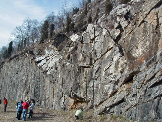
Folded
This beautiful exposure of rocks is part of Bays Mountain, a mountain in the Valley and Ridge province of Tennessee. The vertical lines you see across the road cut are the remnant of dynamiting to allow the road to pass; workers drilled holes in the rock from above and placed dynamite into the holes. When they detonated the dynamite, it blasted away all the rock that used to be where the photographer was standing; creating a solid cliff that won’t collapse when a road is built next to it. The vertical lines are the remnants of the holes drilled for dynamiting.
These rocks started their life as sediments during the Ordovician. At that time, much of what is today the east coast of the United States sat underwater accumulating sediments. These layers are a mixture of carbonates and fine-grained shales, accumulated in quiet water far from the ancient coastline. These layers are part of a geologic unit known as the Sevier shale; several hundred meters of sediment much like this accumulated during this time period. A few hundred million years later, the continent of Africa came rafting in and collided with North America, uplifting the Appalachian Mountains and folding and faulting the sediments deposited off the coastlines of the two continents.
These rocks today are part of the Valley and Ridge province; if you travel through this part of the country, you’ll find long mountain ranges running north-south that are the remnant of these folded and faulted sediments.
These rocks have been warped into a syncline. They’ve been bent up on the sides, a type of fold where the youngest rocks are in the center of the fold. The opposite type of fold is an anticline; in that case, the rocks are bowed upwards in the center, so that the oldest rocks are at the center of the fold. Ironically, this syncline is forming the core of a long ridge even though it seems like the rocks have been folded downwards.
In this case, the folding happened so long ago that even though these rocks were a syncline, the folding is not controlling the topography, erosion is. The rocks at the center of the syncline are harder to erode than the rocks on the limbs, so the center of the syncline is standing up as a mountain today. Something very similar happens at the incredible Sideling Hill outcrop farther north (https://tmblr.co/Zyv2Js1yyAl37).
If you look at the image closely, you can see all sorts of fractures that have been filled with newly grown minerals. These are especially common right at the axis of the fold, where the rocks have been bent the most.
-JBB
Image credit: James St. John https://flic.kr/p/Y5jzAf
References: https://bit.ly/2N7JOdY https://on.doi.gov/2tKfmxl
#geology#syncline#tennessee#great smoky mountains#bays mountain#travel#nature#rock#erosion#science#geomorphology#ordovician#the earth story#valley and ridge
137 notes
·
View notes
Video
youtube
Syncline Grenache Blanc '15 - 93 Points - Episode #2533 - James Melendez
0 notes
Last Seen Blogs

seatokki
Twink Whisperer

villcnelles
𝒃𝒆𝒌𝒂𝒉

jacob-richard
Well...

pfamsingaporesale-blog
PFAM Sale

0mrshadow0
제목 없음