#cyclonicstorm
Photo

Freddy on its way.. 🌀 #cyclone #cyclonicstorm #february #2023 (at Mauritius, Indian Ocean, Africa) https://www.instagram.com/p/Co2h8RbK1tw/?igshid=NGJjMDIxMWI=
0 notes
Text
#SomewhereDeepInTheNight "A #cyclonicstorm in #Jupiter’s northern hemisphere is captured in this image from NASA’s #Juno spacecaft. Many bright white cloud tops can be seen popping up in and around the arms of the rotating storm."
1 note
·
View note
Photo
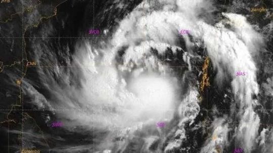
IMD issues 'red-alert' for the coastal areas of Andhra Pradesh as cyclone Asani is likely to come near the cost of Andhra Pradesh. Mild to severe rainfall is predicted for some regions of AP. Asani cyclone is moving at a speed of 6kmph. Multiple flights have been cancelled. The India Meteorological Department, has said that the severe Cyclonic Storm 'Asani' weakened into a 'cyclonic storm' and is likely to become a depression by Thursday morning. #CycloneUpdate #Andhra #IMD #Cyclonicstorm #cyclones #asani #storm #weather #andhrapradesh #cyclonicstorm https://www.instagram.com/p/CdaQIDQLVVW/?igshid=NGJjMDIxMWI=
0 notes
Photo

Andaman and Nicobar Islands brace for Cyclone Asani
https://india24.live/national/andaman-and-nicobar-islands-brace-for-cyclone-asani/
#andamanandnicobarislands#asani#asani cyclone#cyclone#cycloneasani#cyclonicstorm#ICG#ICGships#indiameterologicaldepartment#nationaldisasterrescueforce#indiameteorologicaldepartment#NDRF#unionterritory#weathernews
0 notes
Link
1 note
·
View note
Text
Cyclonic Storm JAWAD: Likely to Move Along Odisha Coast Reaching Near Puri

December 3
Cyclonic Storm JAWAD likely to Move Along Odisha
The Deep Depression over west-central Bay of Bengal intensified further into Cyclonic Storm JAWAD (Pronounced as JOWAD) and moved north-northwestwards with
a speed of 25 kmph during past 06 hours, and currently, lay centered over west-central of Bengal. which is about 420 km south-southeast of Vishakhapatnam (Andhra Pradesh), 530 km south-southeast of Gopalpur (Odisha) and 650 km south-southwest of Paradip (Odisha).
It is likely to move northwestwards, intensify further and reach west-central Bay of
Bengal off north Andhra Pradesh – south Odisha coasts by tomorrow, the 4th December
morning.
Thereafter it is likely to recurve north-northeastwards and move along Odisha coast reaching near Puri around 5th December noon. Subsequently it is likely to continue to move north-northeastwards along coastal Odisha towards West Bengal coast.
Wind warning
During next 6 hours, it will move with wind speed of 60-70 kmph gusting to 80 kmph over west-central and adjoining southeast & east-central Bay of Bengal.
Winds speed reaching 70-80 kmph gusting to 90 kmph is likely to prevail over
west-central & adjoining northwest Bay of Bengal from today evening and gradually
increase becoming 90-100 kmph gusting to 110 kmph over northwest & adjoining west-central Bay of Bengal from the evening of 4th December for the subsequent 12 hours.
Squally wind speed reaching 45-55 kmph gusting to 65 kmph likely to commence along
& off North Andhra Pradesh – Odisha coasts from the mid-night of today, the 3
rd December and increase gradually becoming 80-90 kmph gusting to 100 kmph from 4th
evening, for the subsequent 12 hours.
Squally wind speed reaching 45-55 kmph gusting to 65 kmph also is likely to commence
along & off West Bengal coast from 4th December evening and become Gale wind speed
reaching 60-70 kmph gusting to 80 kmph from the morning of 5th December for the
subsequent 12 hours.
Rainfall warning
3rd Dec.: Light to moderate rainfall at many places with heavy to very heavy rainfall at
isolated places over north coastal Andhra Pradesh and south coastal Odisha.
4th Dec.: Light to moderate rainfall at most places with heavy to very heavy rainfall &
extremely heavy falls at isolated places very likely over south coastal Odisha and north
coastal Andhra Pradesh and heavy to very heavy rainfall at isolated places over north
coastal Odisha & adjoining interior districts and also over coastal districts of Gangetic west
Bengal.
5th Dec.: Light to moderate rainfall at many places with heavy to very heavy rainfall at
isolated places likely over Gangetic West Bengal & north Odisha and heavy rainfall at
isolated places over Assam & Meghalaya, Mizoram and Tripura.
6th Dec.: Light to moderate rainfall at many places with heavy to very heavy rainfall at
isolated places likely over Assam & Meghalaya, Mizoram and Tripura and heavy rainfall at
isolated places over west Bengal.
Read the full article
0 notes
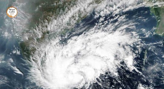
Photo

Cyclone Yass is causing destruction in the Eastern States of the country!
Read the details here!...
#Cyclone#CyclonicStorm#Yaas#CycloneYaas#BengalCyclone#CyclonicHurricanes#BayofBengalCyclone#OrissaCyclone#WestBengal#Orissa#Odisha#Jharkhand
0 notes
Photo
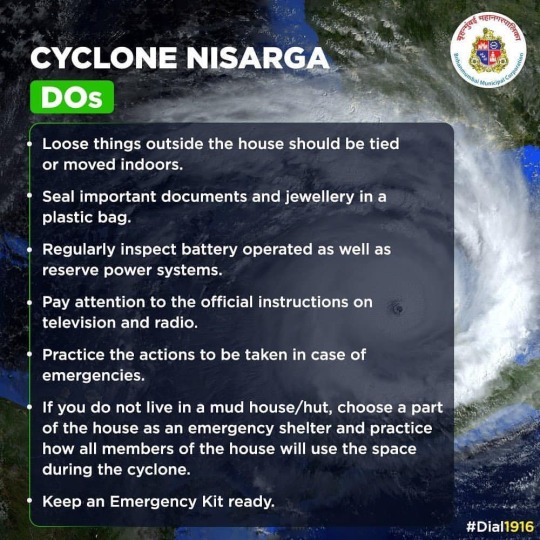
DOs and DONTs for Mumbaikars to take on Cyclone Nisarga. Dial 1916 and Press 4 for any cyclone related query or concern. #CycloneNisarga | Cyclonic Storm with a maximum sustained wind speed of 100-110 kmph gusting to 120 kmph. It is very likely to intensify into a #CyclonicStorm during next 06 hours and further into a Severe Cyclonic Storm during subsequent 12 hours. @imd_weather_reports @ndmaindia #nisarga #goa #mumbai #maharashtra #gujarat #india #toofan #strom #heavyrain #netitharamnews #netitharam #ndrf #pmo #shivsena #uddhavthackerray (at Maharashtra) https://www.instagram.com/p/CA8N6GSHH1O/?igshid=tudggc0cpqrf
#cyclonenisarga#cyclonicstorm#nisarga#goa#mumbai#maharashtra#gujarat#india#toofan#strom#heavyrain#netitharamnews#netitharam#ndrf#pmo#shivsena#uddhavthackerray
0 notes
Photo
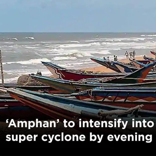
Cyclonic storm ‘#Amphan’ is likely to intensify into a super #cyclone by Monday evening and hit the #WestBengal and #Bangladesh coasts as a very severe cyclone with a #wind speed up to 185 km per hour on Wednesday, the #HomeMinistry said In an advisory to West Bengal and #Odisha governments, the ministry said ‘Amphan’ (pronounced as UM-PUN) is now spotted over the central parts of South Bay of Bengal and the adjoining central Bay of Bengal The storm is very likely to intensify further into a super #cyclonicstorm by Monday evening Heavy to extremely heavy #rainfall, accompanied by high speed winds and #tidalwaves are expected in the region. #cyclones #cycloneamphan #Amphan #IMD #cyclonicstorms #supercyclone #massivecyclone #severecyclone #indonesia #phillipines https://www.instagram.com/p/CAU8ganh6An/?igshid=1k9zek4fum7jh
#amphan#cyclone#westbengal#bangladesh#wind#homeministry#odisha#cyclonicstorm#rainfall#tidalwaves#cyclones#cycloneamphan#imd#cyclonicstorms#supercyclone#massivecyclone#severecyclone#indonesia#phillipines
0 notes
Text
Cyclonic storm “PABUK” over South China Sea and its emergence into Andaman Sea on 05th January 2019: Pre-cyclone watch for Andaman Islands
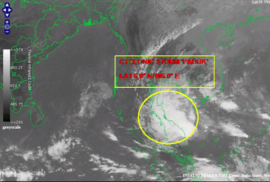
A cyclonic storm “PABUK” lay centred at 0830 hours IST of 03rd January 2019 over south China Sea near latitude 6.0°N and longitude 105.0° E, about 1500 km east-southeast of Port Blair. It is very likely to move west-northwestwards and emerge into Andaman Sea around the forenoon of 05th January 2019. Thereafter it is very likely to move northwestwards and cross Andaman Islands around evening/ night of 06thJanuary. Thereafter, it is very likely to move north-northwestwards and then recurve northeastwards towards Myanmar coast and weaken further during 7th-8thJanuary, 2019.
Warnings:
Heavy rainfall warning
Rainfall at many places with heavy falls at isolated places likely to commence over Andaman Islands from 5thJanuary evening. Intensity is very likely to increase with rainfall at most places and heavy to very heavy rainfall at a few places on 6th and at isolated places on 7th.
(ii) Wind warning
Squally wind speed reaching 40-50 kmph gusting to 60 kmph is likely to commence over Andaman Sea along and off south Myanmar and Thailand coast from 4thJanuary evening. It is very likely to increase gradually becoming 55-65 kmph gusting to 75 over Andaman Sea on 5th and over Andaman Islands, Andaman Sea and adjoining areas of eastcentral and southeast Bay of Bengal on 6th and 7th.
(iii) Sea condition
The sea condition will be rough to very rough over Andaman Sea along and off south Myanmar and Thailand coast from 4thJanuary evening. It is very likely to become very rough to high over Andaman Sea on 5th and over Andaman Sea and adjoining areas of eastcentral and southeast Bay of Bengal on 6th and 7th.
(iv) Fishermen Warning
The fishermen are advised not to venture into Andaman Sea during 4th-7thand into adjoining southeast and eastcentral Bay of Bengal during 6-7thJanuary.
The system is under continuous surveillance and concerned state governments are being informed regularly.
Kindly visit www.imd.gov.in and www.rsmcnewdelhi.imd.gov.infor updates on the system.
Read the full article
#andamanandnicobarislands#CYCLONICSTORM#Cyclonicstorm“PABUK”overSouthChinaSeaanditsemergenceintoAndamanSeaon05thJanuary2019:Pre-cyclonewatchforAndamanIslands#Cyclonicstormbabuk#Pabuk#Storm
0 notes
Photo

S U R V I V A L As cyclones refeed it leaves many a scars. While the ones that have perished will no longer bear this world, the ones who survived have to bear an unknown scar for years to come. A scar that will prepare them for more. In the end, the survivors come out to much more greener than they had began. #cyclone #aftereffect #supercyclone #amphan #trees #life #greens #lifeline #greeneries #nature #devastation #survival #survivingastorm #storm #cyclonicstorms https://www.instagram.com/p/CAcnsBcAZ2h/?igshid=5d09rntthhel
#cyclone#aftereffect#supercyclone#amphan#trees#life#greens#lifeline#greeneries#nature#devastation#survival#survivingastorm#storm#cyclonicstorms
0 notes
Text
Maharashtra and Gujarat braces for Nisarga as the cyclone is set to make landfall tomorrow.
Maharashtra and Gujarat braces for Nisarga as the cyclone is set to make landfall tomorrow.
Maharashtra and Gujarat braces for Nisarga as the cyclone is set to make landfall tomorrow.
Both Maharashtra and Gujarat brace for cyclone Nisarga as it is set to make landfall tomorrow. According to Indian Meteorological Department, the cyclone is likely to make landfall by June 3 afternoon on the western coast. As per IMD’s report, Nisarga will hit the coastal areas as a ‘severe cyclonic…
View On WordPress
#ArabianSea#covid19#cycloneinmumbai#CycloneNisarga#CyclonicStorm#FirstCycloneofMumbai#Gujarat#imd#Indian Meteorological Department#landfall#Maharashtra#Mumbai#National Disaster Response Force#NDRF#Nisarga#pandemic
0 notes
Text
The world's 5 most dangerous storms, which took millions of life

According to the Meteorological Department, there is a possibility of storms going on in 20 states including Delhi-NCR till 11th May. After the warning, there was strong winds, dust storms and rains in Delhi-NCR. The Meteorological Department had issued a warning of Hurricane in Delhi, Gurgaon, Noida and Meerut in Uttar Pradesh and Rajasthan. Indian Meteorological Department (IMD) said that Uttar Pradesh, Bihar, West Bengal, Sikkim, Odisha, Assam, Meghalaya, Nagaland, Manipur, Mizoram, Tripura, Karnataka and Kerala could be affected by the storm-storm. Emergency services have been placed on alert after the warning. When a storm arrives, it causes great devastation and loss of life. Here we are telling you about the most dangerous storm, in which millions of lives were lost.

Image: Stormchasers
Dangerous Storms-
Bangladesh - The 'Great Bhola Cyclone'
This cyclonic storm came to Bangladesh on November 12 and 13, 1970. This storm was so dangerous that nearly 5 lakhs of fatalities were gone. It wreaked havoc for 185 kilometres. This storm caused huge damage to the villages and crops. The storm came to Manikganj district of Bangladesh on April 26, in which about 1300 people were killed and 12 thousand people were displaced. About 80 thousand people were displaced in Daulatpur and Saturia.
Egypt
November 1994, 500 people were killed due to the storm in Egypt's Dronka area. 5 thousand tons of oil was wasted. The storm also affected railways. There was a fire in the oil reservoir due to the fall of thunder.
Zimbabwe
Zimbabwe was called Rhodesia during 1975. On December 23, 1975, 21 people died due to thunder collapse. After this, there was a lot of damage and loss of life.
India
On 30th April 1888, Moradabad had so much rains that 246 people died. Cricket ball-shaped hail fell which killed 1600 animals.
These were some of the dangerous thunderstorms which devastated the world. Share your thoughts in the comment section below.
Read the full article
0 notes
Text
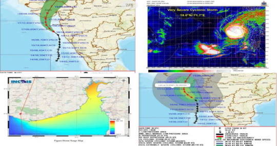
Odisha cyclone update: Low-pressure area forms over South Andaman Sea, to intensify into cyclone by May 8, says IMD
Odisha cyclone update: Low-pressure area forms over South Andaman Sea, to intensify into cyclone by May 8, says IMD
New Delhi: The Low Pressure Area (LPA), formed over South Andaman Sea, is likely to intensify into a depression by today (May 7, 2022) evening and further into a cyclonic storm by Sunday evening, the India Meteorological Department (IMD) said on Friday.
“The #LowPressure Area over South Andaman Sea and neighbouring South-East Bay of Bengal. It will intensify into a #Cyclonicstorm around May 8,…

View On WordPress
0 notes
Photo
Cyclone Yaas: A Cyclone to form over the Bay Of Bengal on 26th May!...
#Cyclone#CyclonicStorm#Yaas#CycloneYaas#BengalCyclone#CyclonicHurricanes#BayofBengalCyclone#OrissaCyclone
0 notes
Text
0 notes
Last Seen Blogs

ghostieyanyan
yanyan here

zeldamasterlist-blog
all the blogs yes

morehocuspocus
pasiones que no me dejan en paz

ugbyj
blue eyes, white dragon

smellthelust
Make a difference