#Panamint Valley
Text
Panamint Valley (iphone)
📸 by Ed Rader Photography
#Ed Rader Photography#Panamint Valley#iPhone#Mojave Desert#Eastern California#USA#Nature#Travel#Photography
14 notes
·
View notes
Text

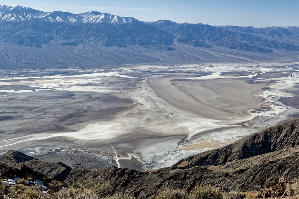
Panamint Valley, Death Valley National Park, 2023.
#landscape#desert#salt pan#panamint valley#death valley national park#inyo county#california#2023#photographers on tumblr
11 notes
·
View notes
Text
Myers Ranch
Myers Ranch is a privately owned ranch located in Goler Wash in the Panamint Mountains of Death Valley National Park, California. The forty acre ranch is privately owned ranch and located about .5 miles from Barker Ranch.
Myers Ranch, Panamint Mountain
A Family Affair
Bill and Barbara Myers settled in Goler Wash in 1932, building themselves a comfortable house complete with such amenities as…
View On WordPress
#California#Charles Manson#Death Valley#Death Valley National Park#Panamint#Panamint Valley#San Bernardino
0 notes
Photo
Panamint Springs, Death Valley, California
54 notes
·
View notes
Text
Hikers are seen in the distance at the Mesquite Sand Dunes in Death Valley National Park, California. This rugged desert landscape holds the world's record for the hottest air temperature—134°F in 1913. Tourists still flock here to experience the blistering heat. Photograph By Raul Touzon, National Geographic Image Collection
How Did Death Valley 🏜️ Gets Its Name? Not From The Heat
In December 1849, a group of settlers seeking their fortunes stumbled upon this inhospitable valley. The few who made it out alive assigned the haunting moniker.
— By Erin Blakemore | July 25, 2023
As a heat wave continues to blanket the Northern Hemisphere, tourists are making pilgrimages to the hottest place on Earth—Death Valley, California—in hope of experiencing a new world-record high temperature. The valley already holds the record for hottest air temperature ever recorded, a whopping 134°F in 1913.
But if they think the valley was named after its scorching summer temps, they’re wrong—it actually got its name from a winter disaster. Here’s how Death Valley got its name, and why it continues to lure visitors with its extreme weather and barren landscape.
Photographing Death Valley’s starry skies shines a light on pollution. A national park artist-in-residence captures the fragility and beauty of the desert at night. August 20, 2020! As an artist-in-residence at Death Valley National Park, photographer Harun Mehmedinović captured images of its night skies and increasing light pollution. In this snowy shot, he caught both stars and, on the right, the glow of the city of Las Vegas. Photograph By Harun Mehmedinović
Inside A Desolate Desert
Located in southeastern California near the Nevada border, Death Valley is nestled in the northern Mojave Desert between four mountain ranges: the Panamint Range to the west, the Amargosa Range to the east, the Grapevine Mountains to the north, and the Owlshead Mountains to the south.
The area’s original inhabitants, the Timbisha Shoshone, lived in harmony with the valley for millennia. But when European settlers encountered it during their westward migration, they were flummoxed by the landscape. Though surrounded by mountain ranges, the valley is situated at the lowest elevation in the United States. The alkaline desert floor is bone dry and lacks vegetation, while the surrounding mountains trap the heat reflected by the sparse desert floor—making it blindingly hot in the summer and inhospitable even in winter.
Even before gold was discovered there in 1849, California attracted white settlers searching for a new life filled with natural riches. Many of these emigrants were completely unprepared for the arduous trip across both mountain and desert—and some fell victim to people who falsely claimed they knew the safest, fastest routes.
In one particularly famous case in 1846, a group of pioneers known as the Donner Party became snowbound after following the shortcut that a booster named Lansford Hastings had advertised. Stuck in the Sierra Nevadas, some of these pioneers eventually resorted to cannibalism and lost nearly half of their group to starvation and exposure.
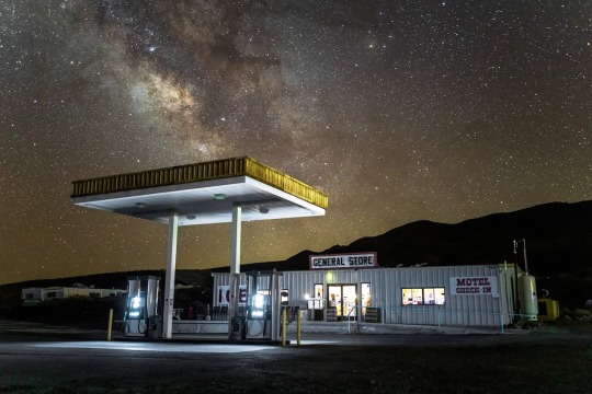
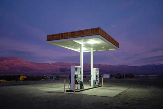
Photographing Death Valley’s starry skies shines a light on pollution. A national park artist-in-residence captures the fragility and beauty of the desert at night. August 20, 2020! The Milky Way looks brighter above Death Valley’s Panamint Springs thanks to the dim lighting at this gas station. Mehmedinović says the image shows the benefit of cutting out excessive light around national parks. Photograph By Harun Mehmedinović
On The Trail To Death Valley
Despite the Donner Party disaster—and the fact that they lacked familiarity with the terrain—boosters and wagon train leaders still attempted to find shortcuts on their journeys to California, especially after gold was discovered there.
In October 1849, members of trail leader Jefferson Hunt’s Mojave San Joaquin Company wagon train grew impatient with Hunt’s pace and his preferred route, known as the Old Spanish Trail. Some worried they’d be stuck in the mountains during the winter like the Donner Party if they didn’t move more quickly. They briefly convinced Hunt to try an alternative route, but Hunt returned from a reconnaissance mission nearly dead of thirst and told them he’d keep to the Old Spanish Trail.
A subset of the party still thought they could find a path west across the Mojave Desert, however—and when they met up with another, smaller party on the trail, they were shown a hand-drawn map of a cutoff that was endorsed, they were told, by some of the region’s most experienced trappers and mountaineers. After Hunt refused to take the shortcut, which would shave 500 miles and potentially months off the journey, much of the party broke off to try out the supposedly superior route.
At first, it seemed like they’d made the right choice: travel was easy, and they made good time. But soon they encountered more and more inhospitable terrain, and increasing disputes about how to proceed. One group headed toward a nearby mountain in hopes of finding water. The other, a group of younger, unmarried men who called themselves “Jayhawkers,” broke off into their own party and attempted to press due west to find the mountaineers’ advertised trail—a route that, it turns out, didn’t really exist.
As both groups journeyed, water became harder to find, and many turned back in search of Hunt rather than face the coming winter in the deadly Sierras. “Grass there is scarce, wood there is none,” wrote Jayhawker Sheldon Young of the landscape. “It is a dubious looking country.”
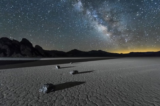
Photographing Death Valley’s starry skies shines a light on pollution. A national park artist-in-residence captures the fragility and beauty of the desert at night. August 20, 2020! Light pollution from cities can encroach on rural areas. Here, in Mehmedinović’s photograph of Death Valley’s Racetrack Playa, the glow on the right comes from Las Vegas, more than 200 miles away. Photograph By Harun Mehmedinović
Disaster Strikes
Weak and exhausted, in December 1849 both groups eventually entered a massive valley filled with salt flats and surrounded by mountains on all sides. Water was scarce in the desert valley; they were only able to locate highly alkaline water sources.
The Jayhawkers slaughtered many of their own oxen to eat and walked across the valley, eventually finding a Native American who guided them to safety. The other party tried going the other direction. As they pressed onward, this time another group of men decided to strike out on their own, and would ultimately die of exposure along their preferred trail.
On the verge of dehydration, the remaining members of the original party were briefly saved by a snowstorm. But over time, oxen dropped dead from thirst and exhaustion, and several men died. Finally, all but a few of the men broke off find their way over the mountains. The others waited patiently at the bottom of the valley.
Finally, after more than a month, the remaining party members—mostly women and young children—were rescued by two young men they’d sent off to get supplies. As they made their final crossing of the Panamint Mountains, one of the party members is said to have turned toward the valley and said “Goodbye, Death Valley.” Overall, it took the shortcut seekers more than four months to find their way to the part of California they sought.
Photographing Death Valley’s starry skies shines a light on pollution. A national park artist-in-residence captures the fragility and beauty of the desert at night. August 20, 2020! "These images are meant to evoke a sense of wonder and curiosity,” says Mehmedinović. “I see images as a gateway to a discussion on the importance of the night sky and our impact on the environment.” Photograph By Harun Mehmedinović
The Highest Temperature Recorded on Earth?
The name stuck—and today, the valley is still known as one of the most barren and dangerous places in the United States. In 1913, the ambient air temperature reportedly rose to 134 degrees, still the world-record high air temperature.
Modern-day meteorologists dispute this reading, pointing out that the temperature was not in line with that of other nearby places and that even freak “hot spots” in the valley cannot account for those variations.
“It is possible to demonstrate that a temperature of 134°F in Death Valley on July 10, 1913, was essentially not possible from a meteorological perspective,” wrote meteorologist Christopher C. Burt in a 2016 analysis. However, the World Meteorological Organization, which validates world-record temperatures, still considers the reading a world record.
The group “is always willing to investigate any past extreme record when new credible evidence is presented,” the WMO wrote in a 2020 release, but to date the analysis has never been officially invalidated.
In the meantime, as a potential new extreme approaches, the organization says it’s ready to examine and validate any new records. Death Valley may not have gotten its name from a scorching summer’s day. But 174 years after it was named, the barren, salty valley is still as inhospitable as it was in 1849.
#Death Valley 🏜️#Inhospitable#California#High Temperature World Record#Desolate Desert 🐪#Mojave Desert#Timbisha Shoshone#European Settlers#United States 🇺🇸#The Alkaline Desert 🌵#Donner Party#Sierra Nevadas#Cannibalism#Jefferson Hunt#Mojave San Joaquin#Jayhawkers#Deadly Sierras#Panamint Mountains ⛰️#Meteorologist Christopher C. Burt#World Meteorological Organization (WMO)
0 notes
Text

A popular spot in Death Valley National Park is a high prominence known as Dante’s View. It is named for Dante Alighieri, author of Divina Commedia (The Devine Comedy). This seems rather fitting as, while it is beautiful, you can probably find plenty of the circles of Hell in Death Valley, especially in summer. On this evening standing at the edge of the 5600 foot elevation and looking over Badwater Basin which is nearly 300 feet below sea level I wasn’t hot, I was darn near hypothermic as I wasn’t really dressed to be there. My car thermometer said it was just over 40 degrees Fahrenheit but that does no justice to the insane winds that are created in such a radical elevation change. I had no way to measure but I guarantee some of the gusts were over 30mph and felt like they blew right through the thin hiking pants I was wearing – just an hour earlier I was sweating in those pants and only a tee shirt on the valley floor.
At least my suffering was rewarded with some beautiful color in the moody sky as the sun dropped over the Panamint Range to the west (camera left)
#original photographers#photographers on tumblr#original photographic works#original photography on tumblr#death valley#death valley national park#national park photography#dante's view
17 notes
·
View notes
Video
flickr
I Found Myself Driving, Hours Upon Hours (Death Valley National Park) by Mark Stevens
Via Flickr:
I Found Myself Driving, Hours Upon Hours Just for the possibility of seeing this again Recent snow storms had allowed me To see another beauty of southern California But it also closed roads, with the one here being one At least, until earlier that day You didn’t disappoint years ago And you’re still wondrous today Mountain peaks and Badwater An imaginary Mos Eisley The wind takes away my breath, Literally and figuratively, when I take in this view Dante’s View, you only bring out awe Another work of short poetry or prose to complement the image captured one afternoon in Death Valley National Park at Dantes View. My thought on composing this image was a simple landscape one with my Nikon SLR camera angled slightly downward to capture a sweeping view down the mountainside, across Badwater Basin, and then to the snowcapped peaks of the Panamint Range. I would lose much of the blue skies above, but I felt this alignment helped to bring out a wider angle, almost panoramic feel with the image captured. My thought on this location brought back memories from April 2015 on an earlier visit seeing this wondrous landscape in a national park. I could imagine a Star Wars setting with Mos Eisley as well as just the natural beauty present. There was a wind blowing that could easily take one’s breath away but had that crisp, cool feel with the low temperatures to make for an enjoyable, brisk walk along the trails and ridges. If you look at the lower portion of the image just left of center, you will notice a what looks like a thin white walkway jutting out. You can zoom in and notice tiny ant people walking along Badwater Basin, almost 6000 feet below!
#Aguereberry Point#Amargosa Range#At Dantes View#Azimuth 311.90#Badwater Basin#Bald Peak#Bennett Peak#Blue Skies#Canvas#Dantes View#Day 4#Desert Landscape#Desert Mountain Landscape#Desert Plant Life#DxO PhotoLab 6 Edited#Free Verse Poetry#Great Basin Ranges#Intermountain West#Joshua Tree National Park and California#Landscape#Landscape - Scenery#Looking NW#Mountain Peak#Mountains#Mountains in Distance#Mountains off in Distance#Mountainside#Nature#Nikon D850#No People
5 notes
·
View notes
Text

Tuesday 28 November Mixtape 400 “Kosmische Village EXCLUSIVE”
Tuesdays & Saturdays.
Support the artists and labels.
Don't forget to tip so future shows can bloom.
Trevlad Sounds-Welcome in you wonderful listener 00:00
Dividenthal & Aumgn-Kosmische Ice Cream 00:31
Self Oscillate-Spajell 05:37
Metamatics-Aeromatix 10:48
Pabellón Sintético-Equinoxe V (Jean Michel Jarre) 16:13
Pete Bassman-Mettalic Decade 19:58
Andrew Weatherall-Vorfreude 2 25:21
Cautionary Guides-Mersey Travel 32:49
Fontän-Gangri - Khjinda Remix 35:36
Charif Megarbane-Souk el Ahad 41:31
Hello Meteor-Way Of Lakes 44:07
Duolant-Glean 47:50
Midwich Youth Club-Summertime Saturday Special 50:13
Arkaean-Ring Cairn Aurora 52:42
Pure Land Stars-Chime The Kettle 1:00:03
Gravité-Glass 1:02:38
Oronzo De Filippi-Termomeccanica 1:06:11
Helios-Impossible Valleys 1:08:33
Lone Bison-Boss Hog Modular 1:12:18
Panamint Manse-Harmony Borax 1:15:23
Lusine, Asy Saavedra-Dreaming 1:19:17
Eulipion Corps-Lourdes 1:23:39
The All Golden-The Wild Future 1:26:50
Cahn Ingold Prelog-WC 28: Dispersion of Light 1:28:44
BVSMV-Input / Output 1:29:34
Fabiano do Nascimento-Yûgen 1:32:45
Dark Fidelity Hi Fi-Tender Tension 1:34:46
Asmus Tietchens-Intrada 1:38:43
HNNY-Yesterday 1:40:05
Wojciech Golczewski-Sunspot 1:43:00
Varsity Star-Spring Heat 1:45:21
Suncastle-Leucrotta 1:49:20
Vic Mars-The Road Through the Village 1:52:18
Timeskater-Ladder 1:55:38
#Dividenthal & Aumgn#Zeit#Self Oscillate#Móatún 7#Metamatics#Pabellón Sintético#Pete Bassman#Höga Nord Rekords#Andrew Weatherall#Cautionary Guides#Castles in Space Subscription Library#Castles in Space#Fontän#Khjinda#Charif Megarbane#Habibi Funk Records#Hello Meteor#Duolant#Woodford Halse#Midwich Youth Club#Arkaean#Silent Season#Pure Land Stars#Centripetal Force#Gravité#Oronzo De Filippi#REDI EDIZIONI#Helios#Keith Kenniff + Hollie Kenniff#Ghostly International
2 notes
·
View notes
Photo

Panamint Valley, Death Valley National Park, USA. December 2022 [OC] (4000 × 1848)
6 notes
·
View notes
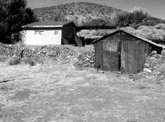
Text
Barker Ranch
Thomason/Barker Ranch is a five-acre property within Death Valley National Park. This historic site is located off of Goler Wash in the southern Panamint Range in the southwestern portion of the park. Barker Ranch is commonly referenced as being the location that mass murderer Charles Manson was arrested after the Tate – La Bianca killings in 1969.
This image, taken circa 1940, shows the main…

View On WordPress
0 notes
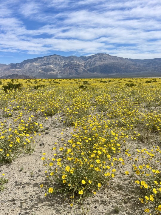
Text
Super Bloom 2023?
Here is the Wildflower Update from the US Forest Service dated January 27,2023 in response to the above question.
Will there be a superbloom this year? The short answer- maybe. It is still too early to predict if the storms from the summer 2022 monsoon season will lead to a showy 2023 spring bloom. Generally, superblooms are preceeded by fall/winter rains, which we did not receive. Sprouts of many wildflower species have been seen popping up on alluvial fans, in washes and around Furnace Creek Visitor Center but whether they survive will depend on many factors including wind, additional precipitation and temperature.
Right now we are anticipating an average to above average bloom this year, but it remains to be seen if there will be a full superbloom. See "Predicting a Good Bloom Year" below to learn more.
Predicting a Good Bloom Year
A good wildflower year depends on at least three things:
Well-spaced rainfall throughout the winter and spring
Sufficient warmth from the sun
Lack of drying winds
Rain is Key
Gentle rain that soaks deeply into the soil is essential for a desert floral display. To begin, a rainstorm of a half inch or more is needed to wash the protective coating off wildflower seeds and allow them to sprout. For plants to continue growing, rainstorms must come at evenly-spaced intervals throughout the winter and spring. The best blooms are triggered by an early, winter-type rainstorm in September or October, followed by an El Niño weather pattern that brings above average rainfall to the Desert Southwest.
Warming Things Up
Wildflower seeds that sprout with cool winter storms often remain small and low to the ground until the springtime sun starts to warm the soil. They may not look like they are growing, but a strong root system is developing below the surface. As the temperatures get warmer, the well established plants then put on a growth spurt and start to bloom.
Harsh Desert Wind
Frequent springtime windstorms without additional rain can bring about a quick end to the spring bloom or even prevent it from happening by killing off delicate sprouts. Dry, moving air dehydrates exposed surfaces of all living things, including human beings. Desert plants often have waxy, hairy, or spiny leaves to baffle the wind and retain precious moisture. Humans can carry and drink water as needed, but the wildflowers must grow and bloom before they dry out, or late-spring heat arrives, in order to leave seeds scattered on the desert floor to produce the next generation.
When Wildflowers Typically Bloom
Mid February to Mid April
Where: Lower elevations on alluvial fans and foothills.
Wildflowers: Desert Gold (Geraea canescens), Notch-leaf Phacelia (Phacelia crenulata), Caltha-leaf Phacelia (Phacelia calthifolia), Golden Evening Primrose (Camissonia brevipes), Gravel Ghost (Atrichoseris platyphylla), Bigelow Monkeyflower (Mimulus bigelovii), Desert Five-spot (Eremalche rotundifolia)
Early April to Early May
Where: 3000 to 5000 feet elevations, upper desert slopes, canyons, higher valleys
Wildflowers: Desert Dandelion (Malacothrix glabrata), Brittlebush (Encelia farinosa), Princesplume (Stanleya pinnata), Desert Paintbrush (Castilleja chromosa), Fremont Phacelia (Phacelia fremontii), Mojave Aster (Xyloriza tortifolia), Bigelow's Coreopsis (Coreopsis bigelovii), Indigo Bush (Psorothamnus arborescens), Desert Globemallow (Sphaeralcea ambigua)
Early May to Mid July
Where: 5000 to 11,000 feet elevation on mountain slopes, pinyon pine/juniper woodlands
Wildflowers: Desert Mariposa (Calochortus kennedyi), Purple Sage (Salvia dorrii), Rose Sage (Salvia pachyphylla), Panamint Penstemon (Penstemon floridus austinii), Magnificent Lupine (Lupinus magnificus), Inyo Lupine (Lupinus excubitus)
Fleeting Beauty

NPS / E. Hoerner
Past Wildflower Seasons
2022
Although we received rain in July, it came too early; rain is usually required in the fall to produce a large bloom. This fall was not only dry, but also hot, with above average temperatures in November. However, several rain events in December thoroughly wet the soil, which was good news for wildflowers, leading to an average bloom (not a super bloom) this spring.
3 notes
·
View notes
Text
Vagabonding as a Spiritual Path
The natural world is my muse and sanctuary -- a place for refuge and discovery. My most memorable moments have been in the outdoors. I have hiked thousands of miles of trails through forests, deserts and mountains. Having spent much of my life traveling and trekking, I still crave adventure and new experiences. Vagabonding or nomadic wandering is a unique way of living, a spiritual path to authenticity, self-awareness and solitude. Solitude allows time for self-examination, relaxation away from urban stress, and a chance to meditate, contemplate, or just zone out for hours at a time. Many of my most memorable experiences took place during solo journeys into Nature. The longer the solo immersion, the more transformational the experience.
In October 2011, I felt Spirit calling me. I felt compelled to travel to the sacred sites and power places that beckoned me. I followed my intuition and deepest instincts. I traveled with my drum and medicine bundle to shamanize the meridian system of Mother Earth's numinous web, which is the planetary counterpart to the acupuncture meridian system of the human body. At the intersection points of the planet's energy web exist holy places, power spots, or acupuncture points. Like acupuncture needles, humans are capable of maintaining the harmonious flow of the planetary energy meridians by making an Earth connection at power places.
Many magical things happened during my two month pilgrimage. I camped at Panther Meadows on Mount Shasta. I hiked among the oldest living things on the Earth in the Ancient Bristlecone Pine Forest. I soaked in the healing waters of Umpqua, Buckeye, Travertine, Whitmore, and Keough Hot Springs. Indigenous people worldwide believe that where fire and water mix at a hot spring is a sacred place. A water deity, usually a goddess, resides in each spring. People make pilgrimages to thermal springs to connect with the goddess and to supplicate the benefits of her healing graces. The sacred ambience of the place, its geothermal energy and the pilgrim's relationship to it, is sufficient to fulfill the pilgrim's aspirations.
I ventured south through California and explored the Owens Valley area on the east side of the Sierra Nevada crest. Before returning home in early December, I planned a four day desert exploration. On day one, I visited the Sleeping Lizard, which is an ancient vision quest site located in the Volcanic Tablelands north of Bishop. This site is sacred to the Owens Valley Paiute people, who use alcoves in the rock for vision quests. I took a journey back in time to visit the ancient ones who etched petroglyphs in the volcanic rock.
Next, I drove up the Whitney Portal Road towards the trailhead that hikers climb up to Mount Whitney. Unfortunately the road to the trailhead was closed for the winter. I backtracked down the road and camped in the Alabama Hills, located in the shadow of Mount Whitney just west of Lone Pine. The rounded weathered contours of the reddish-orange foothills contrast with the sharp ridges of the Sierra Nevada to the west. Throughout the last century, the Alabama Hills have appeared in hundreds of films and commercials. During my visit, a Quintin Tarantino project (Django Unchained) was being shot there.
In one day I drove from Mount Whitney (the sacred masculine), the tallest mountain in the continuous 48 states, into Death Valley (the sacred feminine), the lowest elevation in North America. Shortly after entering Death Valley National Park, I took an eight-mile detour north along the Saline Valley Road to visit a Joshua Tree forest at Lee Flat. The Saline Valley Road is very rough and progress was slow, but I eventually reached the magical forest. A cold wind buffeted me each time I left the confines of my truck to hike and photograph the forest. I would have camped here for the night if not for the high elevation and bitter cold wind. I camped instead at Panamint Springs Resort, 22 miles inside the western border of Death Valley National Park.
The following day, I explored Darwin Falls and the remote Panamint Valley adjacent to Death Valley. I camped for the next few days at the far northeast end of the South Panamint Dry Lake, a small wetland, grassland, dune system and mesquite bosque. The warm sulfur springs of this desert oasis provide habitat for frogs, shore birds, marsh hawks, and wild burros. A short-eared owl visited my campsite each evening at dusk. The stars bathed the cold desert in a warm glow. Few things are more serene than the deep stillness of the desert on a starry night. In that stillness, I am reborn, forever changed.
Oh, how I love vagabonding. Shamanism is deeply rooted in Nature and a nomadic lifestyle. The emphasis is on the individual, of breaking free and discovering one's own uniqueness in order to bring something new back to the group. Like drumming, nomadic wandering alters your ordinary everyday awareness. It is another means of habitual pattern disruption for reimprinting on alternate realties. When you leave home, meet new people, experience new stimuli, and process new information, you're soon intoxicated on a natural high. As Ed Buryn, the godfather of modern vagabonding puts it, "Vagabonding is nothing less than reality transformation, and its power is not to be underestimated."
7 notes
·
View notes
Text
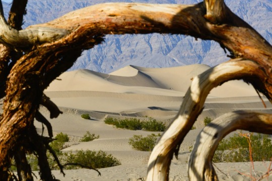
Death Valley Road Trip
April 1, 2024
Yes, I really did go, and these are real photos of Death Valley, not some AI April Fools’ prank. Just want to share a few photos of the many that I took on a recent camping trip to this magical place. I’ll do some more extensive posts soon.
Panamint Range / Telescope Peak
This first photo is from my drive into the park from the south on Panamint Valley Road on March 17. The high…
View On WordPress
0 notes
Text
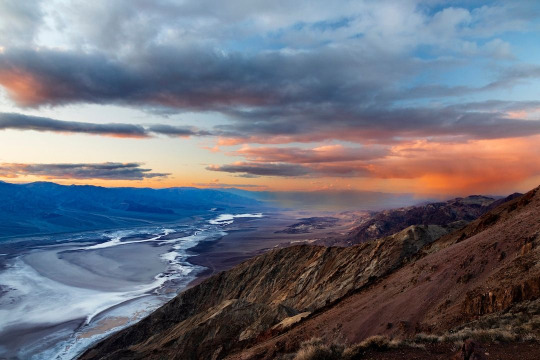
A popular spot in Death Valley National Park is a high prominence known as Dante’s View. It is named for Dante Alighieri, author of Divina Commedia (The Devine Comedy). This seems rather fitting as, while it is beautiful, you can probably find plenty of the circles of Hell in Death Valley, especially in summer. On this evening standing at the edge of the 5600 foot elevation and looking over Badwater Basin which is nearly 300 feet below sea level I wasn’t hot, I was darn near hypothermic as I wasn’t really dressed to be there. My car thermometer said it was just over 40 degrees Fahrenheit but that does no justice to the insane winds that are created in such a radical elevation change. I had no way to measure but I guarantee some of the gusts were over 30mph and felt like they blew right through the thin hiking pants I was wearing – just an hour earlier I was sweating in those pants and only a tee shirt on the valley floor.
At least my suffering was rewarded with some beautiful color in the moody sky as the sun dropped over the Panamint Range to the west (camera left).
In my Etsy shop: https://buff.ly/4cjm7en
Prints and merch on demand: https://buff.ly/49HrbYa
#original photographers#photographers on tumblr#original photographic works#original photography on tumblr#death valley national park#death valley#desert view#gorgeous sunset
12 notes
·
View notes
Last Seen Blogs

argisthebulwark
Sorry, Lass

cellophxne-blog1
They Call Me Cellophane
lustandfairydust
Little Wanderer.

anzadesu
Anza
queerkataguiri
Queer Kataguiri