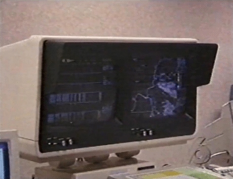
#Nexrad
Photo


415 notes
·
View notes
Photo
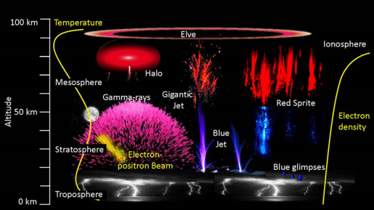
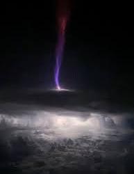
3D study of “Gigantic Jet” provides new insights into upward lightning bursts Peer-Reviewed Publication GEORGIA INSTITUTE OF TECHNOLOGY A detailed 3D study of a massive electrical discharge that rose 50 miles into space above an Oklahoma thunderstorm has provided new information about an elusive atmospheric phenomenon known as gigantic jets. The Oklahoma discharge was the most powerful gigantic jet studied so far, carrying 100 times as much electrical charge as a typical thunderstorm lightning bolt. The gigantic jet moved an estimated 300 coulombs of electrical charge into the ionosphere – the lower edge of space – from the thunderstorm. Typical lightning bolts carry less than five coulombs between the cloud and ground, or within clouds. The upward discharge included relatively cool (approximately 400 degrees Fahrenheit) streamers of plasma, as well as structures called leaders that are very hot – more than 8,000 degrees Fahrenheit. “We were able to map this gigantic jet in three dimensions with really high-quality data,” said Levi Boggs, a research scientist at the Georgia Tech Research Institute (GTRI) and the paper’s corresponding author. “We were able to see very high frequency (VHF) sources above the cloud top, which had not been seen before with this level of detail. Using satellite and radar data, we were able to learn where the very hot leader portion of the discharge was located above the cloud.” Boggs worked with a multi-organization research team, including the Universities Space Research Association (USRA), Texas Tech University, the University of New Hampshire, Politecnica de Catalunya, Duke University, the University of Oklahoma, NOAA’s National Severe Storms Laboratory, and the Los Alamos National Laboratory. The research was reported Aug. 3 in Science Advances, a peer-reviewed, multidisciplinary, open-access scientific journal. Steve Cummer, professor of electrical and computer engineering at Duke, uses the electromagnetic waves that lightning emits to study the powerful phenomenon. He operates a research site where sensors resembling conventional antennas are arrayed in an otherwise empty field, waiting to pick up signals from locally occurring storms. “The VHF and optical signals definitively confirmed what researchers had suspected but not yet proven: that the VHF radio from lightning is emitted by small structures called streamers that are at the very tip of the developing lightning, while the strongest electric current flows significantly behind this tip in an electrically conducting channel called a leader,” Cummer said. Doug Mach, a co-author of the paper at the Universities Space Research Association (USRA), said the study was unique in determining that the 3D locations for the lightning’s optical emissions were well above the cloud tops. “The fact that the gigantic jet was detected by several systems, including the Lightning Mapping Array and two geostationary optical lightning instruments, was a unique event and gives us a lot more information on gigantic jets,” Mach said. “More importantly, this is probably the first time that a gigantic jet has been three-dimensionally mapped above the clouds with the Geostationary Lightning Mapper (GLM) instrument set.” Gigantic jets have been observed and studied over the past two decades, but because there’s no specific observing system to look for them, detections have been rare. Boggs learned about the Oklahoma event from a colleague, who told him about a gigantic jet that had been photographed by a citizen-scientist who had a low-light camera in operation on May 14, 2018. Fortuitously, the event took place in a location with a nearby VHF lightning mapping system, within range of two Next Generation Weather Radar (NEXRAD) locations and accessible to instruments on satellites from NOAA’s Geostationary Operational Environmental Satellite (GOES) network. Boggs determined that the data from those systems was available and worked with colleagues to bring it together for analysis. “The detailed data showed that those cold streamers start their propagation right above the cloud top,” Boggs explained. “They propagate all the way to the lower ionosphere to an altitude of 50-60 miles, making a direct electrical connection between the cloud top and the lower ionosphere, which is the lower edge of space.” That connection transfers thousands of amperes of current in about a second. The upward discharge transferred negative charge from the cloud to the ionosphere, typical of gigantic jets. The data showed that as the discharge ascended from the cloud top, VHF radio sources were detected at altitudes of 22 to 45 kilometers (13 to 28 miles), while optical emissions from the lightning leaders remained near the cloud top at an altitude of 15 to 20 kilometers (9 to 12 miles). The simultaneous 3D radio and optical data indicate that VHF lightning networks detect emissions from streamer corona rather than the leader channel, which has broad implications to lightning physics beyond that of gigantic jets. Why do the gigantic jets shoot charge into space? Researchers speculate that something may be blocking the flow of charge downward – or toward other clouds. Records of the Oklahoma event show little lightning activity from the storm before it fired the record gigantic jet. “For whatever reason, there is usually a suppression of cloud-to-ground discharges,” Boggs said. “There is a buildup of negative charge, and then we think that the conditions in the storm top weaken the uppermost charge layer, which is usually positive. In the absence of the lightning discharges we normally see, the gigantic jet may relieve the buildup of excess negative charge in the cloud.” For now, there are a lot of unanswered questions about gigantic jets, which are part of a class of mysterious transient luminous events. That’s because observations of them are rare and happen by chance – from pilots or aircraft passengers happening to see them or ground observers operating night-scanning cameras. Estimates for the frequency of gigantic jets range from 1,000 per year up to 50,000 per year. They’ve been reported more often in tropical regions of the globe. However, the Oklahoma gigantic jet – which was twice as powerful as the next strongest one – wasn’t part of a tropical storm system. Beyond their novelty, gigantic jets could have an impact on the operation of satellites in low-earth orbit, Boggs said. As more of those space vehicles are launched, signal degradation and performance issues could become more significant. The gigantic jets could also affect technologies such as over-the-horizon radars that bounce radio waves off the ionosphere. Boggs is affiliated with the Severe Storms Research Center, which was established at GTRI to develop improved technologies for warning of severe storms, such as tornadoes, that are common in Georgia. The work on gigantic jets and other atmospheric phenomena is part of that effort.
8 notes
·
View notes
Text
Nexrad off the shits tonight
#guess im not sleeping today 🤷#nonstop quaking and shaking thunder#how the hell am i gonna drive to work.....my route is gonna be flooded....
2 notes
·
View notes
Text
Hal Turner Radio Show - NexRAD Weather Radar Outage - Nationwide
https://halturnerradioshow.com/index.php/en-us/news-page/news-nation/nexrad-weather-radar-outage-nationwide
View On WordPress
0 notes
Link
GR2Analyst Crack is a latest version of NEXRAD level 2. And it is an analytic software application.the user can make their own product.......
0 notes
Text
Our rather interesting flight EP#1
This is by far one of my most memorable teaching moments in my flying career. Me and my father departed from centennial airport (APA) for Kansas city downtown (MKC) in the SF50 vision jet. My father needed to do a plane swap for a new demonstration aircraft so he allowed me to come along. The flight out there was rather uneventful, it was a beautiful July evening and not a thunderstorm in sight.

Arriving into MKC
We arrived out in Kansas city and went and grabbed dinner in the downtown area with my dads coworker, thank god we did because the next few hours were about to become chaotic.

SF50 side by side
Within the next hour and a half there were two MASSIVE thunderstorms that popped up, one being south of our route of flight and one being north. These thunderstorms were rapidly growing, and slowly closing in on each other which would close our gap along our route of flight. With this being a normal thing in the summer we didn't think much about it so we quickly departed MKC for APA and had a nice gap between the two thunderstorms.
In a normal climb out we were just north of the southern thunderstorm by about 20-30 miles. The lightning storm was absolutely beautiful as you watch it all from a distance. Climbing through 14,000 feet we had no weather on our NEXRAD weather, keep in mind here that the NEXRAD is updated every 5-10 minutes. With this rapidly growing thunderstorm, what we were seeing on the radar wasn't what was actually happening outside.
In that climb through 14,000 feet the lightning started to grow dark which was really unusual. We look up and see this massive black tower in front of us and BAM we smack this thunderstorm (which was not on the radar). We immediately hit a crazy updraft so our climb rate went from 2,000 FPM to 8,000 FPM! We were just covered in ice in a matter of seconds. We quickly made a turn back around to the right because we knew the thunderstorm was off our left so we would now fly away from it and allow us to get out of this rapidly growing "cell". Without air traffic controls approval, which in this situation was ok, we made the turn back around and got the aircraft stable enough and outside of the thunderstorm. With that we were now at 19,000 feet and all of this happened in a span of maybe 2 minutes max.
We were now mentally shaken up over what just happened. With that we got a re route over to Omaha Nebraska where we could land and re asses how we wanted to get home. We arrived in Omaha probably around 11pm and got more jet fuel and said that we were just go the really long way. Our new route of flight has us going north of the northern thunderstorm all the way up to the southern part of North Dakota then we would traverse west and pop down over Wyoming.
We did make it back home that night at around 2am in the morning. We were both exhausted but man this was such a good learning moment.
Looking back at this experience there were a few things we could have done better. I wouldn't say our situation was get there idous as we had a clear path between the two thunderstorms so I think we were ok in that context. When it came to us flying into the cell we should have had the onboard weather radar running, this would have gave us accurate weather readings allowing us to know that we were about to fly into a rapidly growing cell. Even with us flying that close to two rapidly growing thunderstorms it should have been instinct to have the onboard radar running giving us information as it scans back and forth getting radar returns.
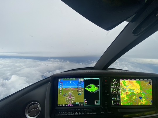
Example of the weather radar on the left and the NEXRAD on the map on the right
With this experience it has taught me to always have backup instruments running so you have more data to make poise decisions.
If there is one thing I can preach to new pilots, it's that there will be moments in your flying career where you will be put up to the task of making poised decisions. My best advice towards this is learn from your mistakes. In our case, we should have ran the weather radar to make sure our decisions were smart. If it weren't for this memorable experience it would not have made me a better pilot. Learn from your mistakes and use it to grow and fly safe!
0 notes
Text
Severe space weather can mess up bird migrations, a new study indicates
See on Scoop.it - Design, Science and Technology
New research indicates that severe space weather events, such as solar flares, disrupt birds' navigational skills during long migrations.
Previous research has indicated that when flying at night, birds (and many other animals) use Earth's magnetic field for navigation. Because solar events disrupt the magnetic field — as well as produce auroras — birds have more difficulty navigating during them. The new study analyzed images taken from 37 NEXRAD Doppler weather radar stations, which can detect groups of migrating birds, as well as data from ground-based magnetometers, to study 23 years of bird migration across the U.S. Great Plains. The 1,000-mile (1,600-kilometer) span from North Dakota to Texas is considered a major migratory corridor for birds.
"The biggest challenge was trying to distill such a large dataset — years and years of ground magnetic field observations — into a geomagnetic disturbance index for each radar site," Daniel Welling, University of Michigan space scientist said in a statement. "There was a lot of heavy lifting in terms of assessing data quality and validating our final data product to ensure that it was appropriate for this study."
The work paid off. The researchers discovered that the number of migrating birds in this region decreases by 9 to 17 percent during severe space weather events. They also noticed increased rates of birds becoming lost during migration, a phenomenon known as migratory bird vagrancy.
Read the full article at: www.space.com
0 notes
Text
How Does Doppler Radar Work? Get the Inside Scoop on How This Important Weather Tool Works
Doppler radar, also known as weather radar, has always been the subject of curiosity among people. How does it work? What purpose does it serve, and how does it detect the weather? We will dive into every detail of doppler radar to answer these questions, and more!
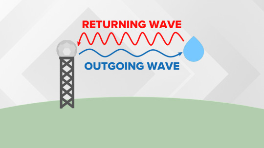
What is Doppler Radar?
Radar is a system that uses electromagnetic waves to detect objects and measure distances. The word doppler comes from a physicist called Christian Doppler who discovered that sound shifts in frequency as the source of sound moves closer or farther away. So, this means that if a wave has an object moving towards it, its frequency will be higher than if it was stationary. It is also known as a Doppler shift. What does a doppler radar do? A radar can use electromagnetic waves to find out what the speed and direction of motion are for any object by measuring how they change with time. They also measure heights, lengths, widths and other distances based on these calculations. These measurements can help forecasters see whether there are storms coming or where wind speeds are located so they can issue weather alerts early enough for people to prepare for bad weather conditions.
The Purpose of Doppler Radar
What is doppler radar, you may ask. It is a weather surveillance system that utilizes radio waves to detect precipitation, winds, and other phenomena. There are two basic types: one being a stationary type that transmits waves in all directions and measures wind speed and direction; the second is a mobile type that emits pulses of energy in pulses or continuous wave form in order to measure precipitation, winds, etc. What Does a Doppler Radar Do? Now we know what it does. What does it measure then?
How Does Doppler Radar Work?
What is doppler radar and what does it do? A doppler radar is a type of weather radar that measures wind speeds and precipitation. It can also measure the direction, height and width of rain, snow or hail. What does a doppler radar measure? One important thing that a doppler radar measures is winds. If you are looking at an area with high winds and want to know if they are severe, the doppler radar will tell you how strong they are (i.e., whether they are over 55 miles per hour). The doppler radar will also tell you what direction the wind is coming from and where it's going to go (i.e., north or east).
The Different Types of Doppler Radar
There are three different types of doppler radar which help measure different things. The first type of doppler radar is WSR-88D or NEXRAD and it measures rain rate, wind speed and direction, temperature and humidity in addition to precipitation. The second type of doppler radar is called TDWR or TEMPO and it measures rainfall rates over a very short period of time. The third type of doppler radar is called ASOS or AWOS. These two radars monitor aviation weather conditions such as visibility and cloud cover.
What does Doppler Radar Measure? It Measures Rain Rate, Wind Speed and Direction, Temperature, Humidity and Precipitation: The National Weather Service uses these measurements to make forecasts by predicting what will happen next with the weather.
The Advantages and Disadvantages of Doppler Radar
Doppler radar is an important tool for meteorologists. What does a doppler radar do? It provides information about wind speed and direction, temperature, and more. However, it can take hours before a storm has enough energy to be detected by this weather tool. Other disadvantages include not being able to detect storms that are too low in the atmosphere or located near mountains or buildings. There are some advantages of using doppler radar though! For example, a doppler radar may be able to detect rainfall from thunderstorms with little rainfall accumulation. When these types of storms occur, we need this type of technology because sometimes the heaviest rain occurs outside of where people live.
0 notes
Photo

#NEXRAD (Next-Generation Radar) is a network of 160 high-resolution S-band Doppler weather radars operated by the National Weather Service#NEXRAD#vhs#gif#weather radar#nws#1995#wpsd
27 notes
·
View notes
Text
Radarscope inspector tool

#Radarscope inspector tool android
#Radarscope inspector tool pro
#Radarscope inspector tool pro
RadarScope Pro Tier 1 provides access to real-time lightning data that animates along with the radar loop and up to 20 frames of radar data, including *extended loops* of Super-Res Level 2 data. Super-res products are still available to all RadarScope users without purchasing a subscription. The RadarScope Pro subscription is an optional auto-renewing subscription with two different tiers to choose from. Spotter Network members can report their location and view the locations of other spotters. You can display data from NOAA's public access web site, our optional WDT feed (the default), or your AllisonHouse subscriber account. Meanwhile, RadarScope will retrieve and display updated data automatically and intelligently (approximately every 2 to 10 minutes, depending on the radar scan strategy). Tap and hold the color legend to see the data values. Display the names of over 25,000 cities and towns on the map as you zoom and scroll. Tap the play button to download and animate over recent images. Plot your current location by tapping the location button and optionally report it to the Spotter Network. Select one of the 156 different NEXRAD radar sites and 45 Terminal Doppler radars in the US, 30 other radar sites in Canada, and 2 in the Republic of Korea. Tap the radar sweep button in the toolbar to switch radars. Drag your finger around the map to scroll. When there are any Tornado Warnings (outlined in RED), Severe Thunderstorm Warnings (YELLOW polygons), or Flash Flood Warnings (GREEN polygons) in effect throughout the US, tap the warning button in the top right corner to browse the list of current warnings, view the details, and even zoom to the selected warning on the map.
#Radarscope inspector tool android
Whether you are scanning reflectivity for a mesocyclone's tell-tale hook echo, trying to pinpoint the landfall of a hurricane's eye wall, or looking for small features like velocity couplets in the storm relative radial velocity product, RadarScope gives you the power to view true radial NEXRAD weather radar on your Android device. These aren't smoothed PNG or GIF images, this is native radar data rendered in its original radial format for a high level of detail. It can display the latest reflectivity, velocity, dual-polarization, and other products from any NEXRAD or TDWR radar site in the United States, Guam and Puerto Rico, as well as reflectivity and velocity data from Environment Canada radars. RadarScope is a specialized display utility for weather enthusiasts and meteorologists that allows you view NEXRAD Level 3 and Super-Resolution radar data along with Tornado, Severe Thunderstorm, Flash Flood Warnings, and predicted storm tracks issued by the US National Weather Service.
0 notes
Text
New york radar in motion

New york radar in motion pro#
Our interactive map allows you to see the local & national weather. The good news is the Senate will be back for votes next week. See the latest New York Doppler radar weather map including areas of rain, snow and ice.
New york radar in motion pro#
The Senate and House will hold brief pro forma sessions because they’re still on recess. District Court Judge Aileen Cannon, a Trump appointee, also ordered the department to share the status of the review of such materials - which the Justice Department said Monday it has almost completed. The Justice Department has until Tuesday to provide a judge in Florida with a detailed list of items removed from former president Donald Trump’s Mar-a-Lago estate. Albany NY animated radar weather maps and graphics providing current Storm Relative Motion of storm severity from precipitation levels with the option of. Steve Bannon pleads not guilty to NY state charges of money laundering, conspiracy and fraud. News agencies, television stations, military installations and other sites have access to the radar images through cooperation with the National Weather Service. Albany, NY Doppler Radar Weather - Find local 12201 Albany, New York radar loop and radar weather images. John Fetterman, the state’s lieutenant governor and Democratic Senate candidate, will not appear with him on this visit. Read the motion for a partial stay of the order here. Doppler Radar The National Weather Service's Doppler radar, known as NEXRAD (for the NEX t generation of RAD ar), is the only Doppler weather radar on Long Island. Biden also is expected to speak on the need to fund police departments, per White House press secretary Karine Jean-Pierre. The president will speak in Wilkes-Barre, Pa., about his administration’s plans to combat the gun violence epidemic. Biden takes first of several trips to Pennsylvania this week. New York NY animated radar weather maps and graphics providing current Long Range Base of storm severity from precipitation levels with the option of seeing static views.Your Home for Nation Radar, Regional Radar, Severe Weather Radar and Local Weather Radar. Other pages on this site will be updated or modified soon. Radar requires three integral parts to work: (1) an antenna/receiver, (2) computers that process the raw radar data, and (3) an interactive workstation that the forecasters can use to display the processed radar data. We fixed are https or SSL certificates, improved load times, improved radar and added your local radar to follow your location. The term WSR-88D is simple to explain: WSR stands for Weather Surveillance Radar 88 represents the year the first NEXRAD was commissioned for use (1988) and the D means it is a Doppler radar. York 78F Cloudy Feels like 78 Wind 5 mph N. Welcome to Live Weather Radar I am always looking to improve the weather radars on this site. York County Regional Police K9 receives new vest 22 hours ago.
0 notes
Text
Weather santa cruz tomorrow

If you need more information about our wind forecast for Opal Cliffs/Santa Cruz, have a look at our help section. For deep dive information check out our hour by hour weather forecast for tomorrow down the page. During the evening and night time the temperatures will drop to 4 ° C. The weather tomorrow in Santa Cruz will be chilly with temperatures around 15 ° C. For converting between wind speed units such as knots, km/h (kilometers per hour), m/s (meters per second), and mph (miles per hour) use our wind speed calculator. The local weather in Santa Cruz tomorrow. Use website settings to switch between units and 7 different languages at any time. These units are often used by sailors, kiters, surfers, windsurfers and paragliders. Bernardo O´Higgins 1 Hurricane Now TOKAGE 10,145 mi away 7 Day 14 Day Hourly Clouds map Weather Radar Alerts Satellites Models Today Aug. We use knots and degrees Celsius as our default units. Santa Cruz (Chile) Weather 05:00 PM Wednesday Sunny interval 55° Feels like 55° South 7 - 23 mph Hourly Cloudy skies for the next few hours There are currently no alerts Libertador Gen. Or use our wind forecast to find the wind speed today in Opal Cliffs/Santa Cruz or to have a look at the wind direction tomorrow at Opal Cliffs/Santa Cruz.įor statistical and historical real weather data see the wind and weather statistics for this location. The arrows point in the direction in which the wind is blowing.Ĭheck the wind forecast for Opal Cliffs/Santa Cruz when you search for the best travel destinations for your kiteboarding, windsurfing or sailing vacations in United States of America. Radar Satellite WunderMap Nexrad Tonight Mon 08/22 Low 58 ☏ 4 Precip. Predictions are available in time steps of 3 hours for up to 10 days into the future. Tomorrows temperature is forecast to be COOLER than today. Forecasts are computed 4 times a day, at about 10:00 PM, 4:00 AM, 10:00 AM and 4:00 PM Pacific Daylight Time. The horizontal resolution is about 13 km. Windfinder specializes in wind, waves, tides and weather reports & forecasts for wind related sports like kitesurfing, windsurfing, surfing, sailing, fishing or paragliding. All the effort goes waste because of a wrong forecast.This is the wind, wave and weather forecast for Opal Cliffs/Santa Cruz in California, United States of America. In addition, Emergency Support Function (ESF), i.e., navy, Fire Brigade, NDRF, and Railways are on alert and standby mode until the alert is lifted. However, only light rainfall was recorded till Monday evening.Įxplaining the impact of wrong forecast and alert, a senior BMC official said, “As per the protocol of red alert, we are required to send out blast SMS asking people not to venture out and step out only if necessary. IMD issues red alert Mumbai sees only light rainĮxtremely heavy rains were expected to lash a few parts of Mumbai on Monday as the weather department issued a ‘red alert’ for the day. However, the IMD maintained that the forecast was not impacted by the defunct radar. What will be the highest temperature tomorrow in Santa Cruz Tomorrow, the highest temperature in Santa Cruz will be 77☏ (25☌), while the lowest temperature will be 57.2☏ (14☌). The radar installed in 2010 at the Regional Meteorological Centre in Colaba in South Mumbai has seen frequent breakdowns in the last four years and has remained defunct since July, the start of the monsoon season this year. What is the weather forecast for Santa Cruz for tomorrow Tomorrow, on Tuesday, the sky will be partially clouded. The doppler radar-which surveys weather patterns, and forecasts- situated at Colaba continued to remain suspended. Fishermen at the Namkhana harbour in South 24 Parganas district on Monday.
0 notes
Text
Weather network radar ny city

#WEATHER NETWORK RADAR NY CITY ANDROID#
#WEATHER NETWORK RADAR NY CITY PRO#
While the top end Tier 2 package adds in hail and shear contouring (the latter necessary for tornado formation), as well as multi-platform use and a 30-day radar archive.īut even for just $9.99 for the app alone without the tiered options, the standard data is fantastic.
#WEATHER NETWORK RADAR NY CITY PRO#
Stepping up to the Pro Tier 1 subscription for $9.99 per year gets you longer animations and lightning data (a must for outdoor enthusiasts), dual pane capability, and inspection tools. You have access to every single radar product that the pros do, at practically the same time they see them-along with up to the minute warning information. KOKX Upton, New York Based Nexrad Doppler Radar Station with Enhanced Nexrad Doppler Radar from the National Weather Service for the General Upton, NY.
#WEATHER NETWORK RADAR NY CITY ANDROID#
Available on Android and iOS for $9.99 and Windows or Mac for $29.99, this app is one of the quickest updating around. Get the forecast for today, tonight & tomorrow's weather for New York City, NY. 40.6 N, 73.94 W New York City, NY Weather History starratehome. Clouds will gradually increase tonight as the humidity increases. If none of the above weather apps have what you’re looking for, and you’re willing to spend money on a quality professional weather radar app or website that storm chasers use, hands down our top recommendation is RadarScope. By Spectrum News Weather Staff New York City.
0 notes
Text
Carrot weather pro apk

Carrot weather pro apk update#
Carrot weather pro apk android#
Carrot weather pro apk series#
Carrot weather pro apk free#
It incorporates weather tracks from the U.S. Plus, the app features more user-friendly tracking that is sensitive to tornadoes, flash floods, severe thunderstorms, and special marine warnings. It also uses Environment Canada and Australian Bureau of Meteorology radars. It uses NEXRAD Level 3 and Super-Resolution radar data, promising to offer real-time reporting for products like reflectivity, velocity, wind speed, and dual-polarization, pulling weather data from 289 NEXRAD and TDWR radar sites here in the U.S., as well as Guam, Puerto Rico, Korea, and Okinawa. RadarScope goes more in-depth than the typical weather app, delivering the kind of information typically reserved for meteorologists and weather enthusiasts.
Carrot weather pro apk series#
CARROT integrates with your Apple Watch, delivering notifications and a series of personalized widgets which you can add to your home screen for the most convenient access.
Carrot weather pro apk update#
You can choose data points and update the layout for a more cheerful view. Animations and dialogue bring the weather to life with optional customization to best suit your preferences. The app integrates with multiple sources to provide the most accurate weather reporting, including details from AccuWeather and Dark Sky - both picks for the best weather app, too.īut what really makes CARROT shine is in its fun, unique character that infuses personality and humor into every weather report. You can also choose to view weather in real-time so you can see immediately how the temperatures are outside.
Carrot weather pro apk free#
It is free to use, too, with optional in-app upgrades if you have some money to spend.ĬARROT tunes into your location to provide instant, hyper-local weather information that is available on a daily or hourly forecast basis.
Carrot weather pro apk android#
Plus, with RealFeel® & RealFeel Shade Temperature™ technology, you no longer have to guess how the weather will feel because it will actually tell you, better helping you prepare for the day ahead.ĪccuWeather works with your smartphone, tablet, or smartwatch to track the weather with both Android and Apple capabilities. An advanced weather radar is also available that provides detailed information in real-time regarding storms for snow, ice, rain, and temperature drops. You can choose daily, hourly, or minute-by-minute weather tracking based on your preference. You can also relax knowing that there are also weather alerts for severe weather. Before you step out into the neighborhood, AccuWeather will help prepare you for the day with reporting on temperatures like WinterCast, precipitation, UV index, and allergens. CloseĪgainst a colorful backdrop sits the AccuWeather app. If you see inaccuracies in our content, please report the mistake via this form. If we have made an error or published misleading information, we will correct or clarify the article. Our editors thoroughly review and fact-check every article to ensure that our content meets the highest standards. Our goal is to deliver the most accurate information and the most knowledgeable advice possible in order to help you make smarter buying decisions on tech gear and a wide array of products and services. ZDNET's editorial team writes on behalf of you, our reader. Indeed, we follow strict guidelines that ensure our editorial content is never influenced by advertisers. Neither ZDNET nor the author are compensated for these independent reviews. This helps support our work, but does not affect what we cover or how, and it does not affect the price you pay. When you click through from our site to a retailer and buy a product or service, we may earn affiliate commissions. And we pore over customer reviews to find out what matters to real people who already own and use the products and services we’re assessing. We gather data from the best available sources, including vendor and retailer listings as well as other relevant and independent reviews sites. ZDNET's recommendations are based on many hours of testing, research, and comparison shopping.
0 notes
Last Seen Blogs


linxdo
Linxdo Art

cur-sedd
Dirty Little Secret

mysticspirits18
Mystic Spirits

densmorephotography
emily densmore photography