#Mappa Mundi
Text


mappa mundi
from the "rylands beatus", a copy of beatus of liébana's 8th c. commentary on the apocalypse of st john, spain, late 12th or early 13th c.
source: Manchester, John Rylands Library, Latin MS 8, fol. 43v-44r
#12th century#13th century#mappa mundi#maps#rylands beatus#beatus of liébana#apocalypse#adam and eve#medieval maps#medieval art
102 notes
·
View notes
Text
Mappa Mundi: The Greatest Medieval Map In The World
— By Anna Bressanin | Wednesday February 14, 2024
Credit: CalimaX/Alamy
From a small island in the Venetian lagoon, a 15th-Century monk somehow designed an astonishingly accurate planisphere of the world.
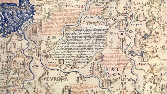
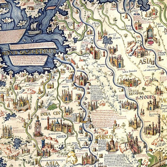
On the second floor of the Library of Saint Mark in Venice, a map of the world occupies an entire room – and rightfully so, considering its historical significance and imposing size (2.4m x 2.4m, bigger than a king size bed). Completed in 1459, the Mappa Mundi is the compendium of all the geographical knowledge of the time and is arguably the greatest medieval map of the world.
Almost twice as large as the famous English Hereford Mappa Mundi (ca 1300), this exquisitely decorated planisphere showcasing Europe, Africa and Asia was the masterpiece of Fra Mauro, a monk of the Camaldolese order who lived on the small Venetian island of San Michele.
Although the monk never set foot outside Venice, his Mappa Mundi is amazingly accurate in its depiction of cities, provinces, continents, rivers and mountains. America isn't on the map, since Christopher Columbus would take his trip across the ocean 33 years later; and nor is Australia. But Japan (or in Fra Mauro's words, "Cipango") is there, making its first appearance on a Western chart. Even more surprisingly, Africa is correctly drawn as circumnavigable, long before the Portuguese rounded the Cape of Good Hope in 1488.
"It's the oldest surviving medieval map," said Meredith Francesca Small, author of the book Here Begins the Dark Sea, also describing it as the most complete medieval map to survive into modernity. "It's the first map to be based on science more than religion. The Hereford map is all propaganda, religious propaganda."
While the Hereford map depicted Heaven and Hell and was designed to serve as a compendium of the world's knowledge from a spiritual perspective, Fra Mauro took a scientific approach to his cartography. He declared in his inscriptions that he would "verify the text by practical experience, investigating for many years and frequenting personas worthy of faith who have seen with their own eyes what I faithfully report here".
There's more than scientific and historical relevance to it, though. The most striking aspect of the map, which immediately catches your eye after ascending the white marble stairs of the Library of Saint Mark, where some of the world's most precious and ancient manuscripts are kept, is its sheer splendour.
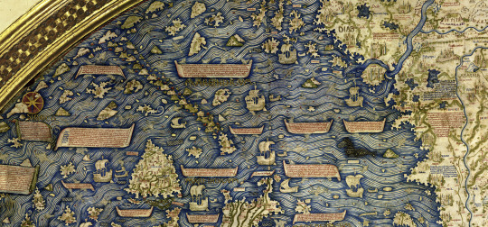
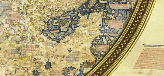
"It's huge, beautiful, fantastically crafted," said historian Pieralvise Zorzi. Beyond the outlines of countries and continents, Fra Mauro's Mappa Mundi is a magnificent golden and blue painting composed of minute drawings of gorgeous palaces, bridges, sailing ships, rolling blue waves and outsized sea creatures, plus a total of 3,000 cartigli – red and blue annotations written in ancient Venetian that tell stories, anecdotes and legends.
In Norway, for instance, a cartiglio indicates the location where the Venetian merchant Pietro Querini came ashore after a shipwreck. As the tale goes, he not only survived the accident, but he brought stockfish back home, thus starting the Venetian passion for baccalà (the creamy fish spread you can find in every osteria).

The Exquisitely Decorated Mappa Mundi measures an impressive 2.4m x 2.4m. Credit: Bildagentur-online/Getty Images
Another cartiglioindicates Tharse, the "kingdom where the Magi came from", then thought to be located somewhere between China and Mongolia.
All these annotations are legible on the map, and are relatively easy to decipher for Venetian speakers since the current dialect is not dramatically different from the idiom of the 15th Century. However, the inscriptions are also translated into English on an interactive map created by the Galileo Institute and Museum in Florence. Displayed on a flat screen in the same exhibition space as the Mappa Mundi, it provides the somewhat peculiar experience of entering the mind of a savant monk and reading the world through his medieval eyes.
It was not a small world. Although Fra Mauro lived his entire life in his island monastery in the lagoon backwaters, he tapped into the knowledge of travellers and merchants who crossed paths in the flourishing trading city of Venice that was "the capital of cartography at the time", explained Saint Marks librarian Margherita Venturelli.
“Maps Were Fundamental For Trade Because If You Have A Good Map, You Can Go Everywhere”
"Maps were fundamental for trade because if you have a good map, you can go everywhere," added Zorzi. "Every innovation in terms of cartography was welcome in Venice, and well-paid."

The Library of Saint Mark is home to one of the world's most significant collections of classical texts. Credit: Mo Peerbacus/Alamy
Fra Mauro's main source for Asia was merchant and fellow Venetian Marco Polo, who had published his travel accounts more than 150 years earlier. On the map, 150 locations are directly traceable to Marco Polo's Travels; for instance, the Mount of Adam was placed in the island of Ceylon (today's Sri Lanka), where, according to legends recounted by Polo, the first man's body was believed to be buried, together with his teeth and even his bowl, which was supposed to have the magical property of multiplying food.
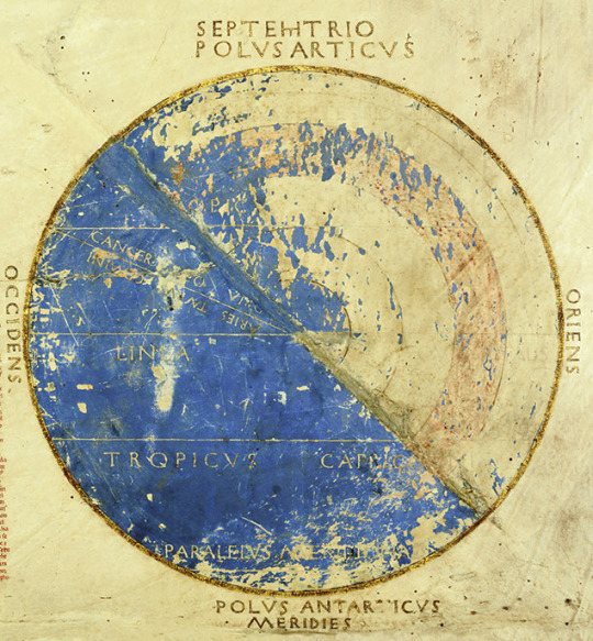
Besides Polo, Fra Mauro had numerous sources around the globe. The fact that the chart looks upside down to contemporary Western eyes, with the south on top, might indicate that he was inspired by Arab cartography, like a 12th-Century map by North African geographer Muhammad al-Idrisi. The numbers that Fra Mauro lists as "the Distance of Heavens" are from mathematician and astronomer Campanus de Novara. "From the centre of the world to the surface of the Earth there are 3,245 miles. From the centre of the world to the lower surface of the heavens of the Moon there are 107,936 miles," and so on, he writes in the top left corner of the Mappa Mundi.
Fra Mauro also displayed a healthy scepticism and wasn't shy of criticising – as well as sometimes using –the revered Ptolemy's Geography, a treaty written in Alexandria, Egypt, by Claudius Ptolemy in 150 CE and lost for centuries to the Western world until it was rediscovered and translated in Latin again in the 1400s.
Fra Mauro's main source for Asia was merchant and fellow Venetian Marco Polo. Credit: The History Collection/Alamy
This Renaissance rationalist attitude also showed in the way he placed Adam and Eve in the Garden of Eden outside of the planisphere, making it clear that Heaven is not a place on Earth; a statement that separated religion and geography and was forward thinking for any medieval man, let alone a monk.
These novelties, and the fact that the map was completed few decades before Christopher Columbus sailed to America, contribute to Fra Mauro's Mappa Mundi being considered the geographical link between the Middle Ages and the Renaissance. To contemporary visitors, his map is a reminder of the fact that maps were once not only practical tools, but also a matter of beauty – and a way to tell the most extraordinary stories.
#Feature#History#Medieval Map#Mappa Mundi#BBC News 🗞️#Anna Bressanin#Venetian Marco Polo#Saint Mark#Library#Fra Mauro
2 notes
·
View notes
Text
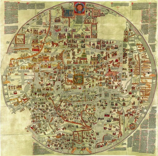
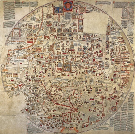
Riproduzione fotografica della perduta mappa mundi del monastero di Ebstorf (ca. 1234)
"Questa enorme mappa rappresentava il mondo come un disco circolare di tre metri e mezzo di diametro; venne disegnata per l’abbazia di Ebstorf in Germania intorno al 1234, da un autore ignoto, che però alcuni associano all’ambito italiano, dal momento che l’abate che commissionò la spettacolare opera, Gervasio di Tilbury, era stato maestro di diritto canonico all’Università di Bologna. Non sono le dimensioni l’aspetto più singolare del mappamondo, ma piuttosto la sterminata messe di disegni e cartigli che ne affollano ogni angolo: il mondo è ricoperto di personaggi del presente, del passato e della fantasia; di storie e di descrizioni, di immagini e didascalie. La carta è insomma una vera e propria enciclopedia di cosmografia, teologia, storia sacra e profana."
6 notes
·
View notes
Photo


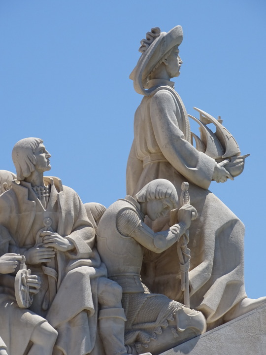

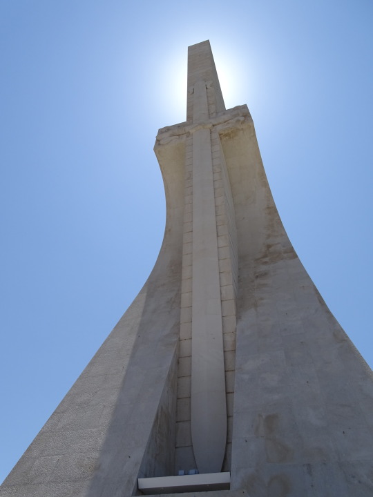

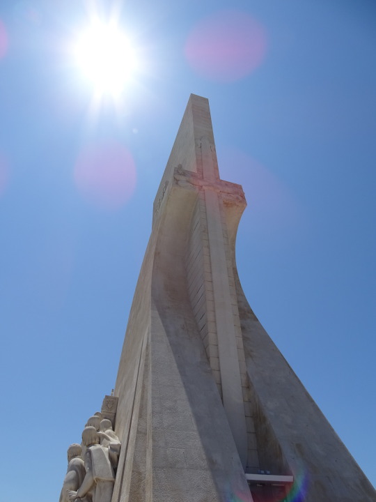
Padrão dos Descobrimentos, Lisbon (No. 3)
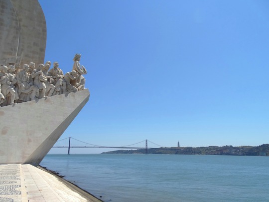
The structure is located on the northern bank of the Tagus River, neighboring the Belém Marina, Algés and Dafundo Nautical Centre, and the Museum of Popular Art (Portuguese: Museu de Arte Popular), and demarcated by stone pedestals with armillary spheres. Opposite the large square, and across the Avenida da Índia-Avenida de Brasília motorway, is the Praça do Império (Empire Square) which fronts the Jerónimos Monastery, Belém Cultural Center and the green-spaces of the Jardim Vasco da Gama.
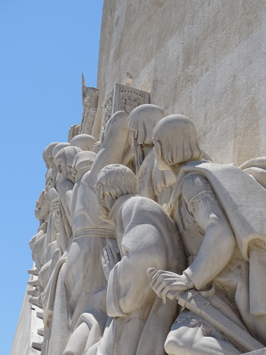
The original structure, which Telmo, Barros and Almeida created, was erected in steel and cement, while the 33 statues were produced in a composite of plaster and tow. Ostensibly a 52-metre-high (171 ft) slab standing vertically along the bank of the Tagus, the design takes the form of the prow of a caravel (ship used in the early Portuguese exploration). On either side of the slab are ramps that join at the river's edge, with the figure of Henry the Navigator on its edge. On either side of the Infante, along the ramp, are 16 figures (33 in total) representing figures from the Portuguese Age of Discovery. These great people of the era included monarchs, explorers, cartographers, artists, scientists and missionaries. Each idealized figure is designed to show movement towards the front (the unknown sea), projecting a direct or indirect synthesis of their participation in the events after Henry.
The South African government was responsible for gifting the construction of the square in front of the monument: the 50-metre-diameter (160 ft) Rosa-dos-Ventos (compass rose) was executed using different types of limestone, including lioz, a rare type of beige limestone found only around Lisbon, more specifically in Sintra. Designed by the architect Cristino da Silva, it includes a Mappa mundi that is 14 metres wide, showing the routes of Portuguese carracks and caravels during the Age of Discovery.
On the northern façade flanking the staircase are two inscriptions in metal: on the left, "AO INFANTE D. HENRIQVE E AOS PORTVGVESES QVE DESCOBRIRAM OS CAMINHOS DO MAR" (To Prince Henry and the Portuguese that Discovered the Roads of the Sea) over a metal anchor; and, on the right, the words "NO V CENTENÁRIO DO INFANTE D. HENRIQVE 1460 – 1960" (On the Fifth centenary of Prince Henry 1460–1960), over a crown of laurel. The double staircase ascends one level, before the entranceway to the monument, allowing a perspective on the square and the lateral figures.
The interior consists of three areas: the auditorium with space for 101 people, a stage of 18 square metres (190 sq ft), with film projection booth; a secondary level with two halls for exhibition; and the last level with four rooms. Normally, the auditorium hosts a multimedia exhibition on the history of Lisbon, while the other rooms are used for exhibitions. The top of the monument (reached via a lift or stairs) offers views of the Tagus river, the Belém neighbourhood and its many attractions, including the Belém Tower and the Jerónimos Monastery, which date from the Age of Discovery.
Source: Wikipedia
#Belém#Padrão dos Descobrimentos#Monument of the Discoveries#Lisbon#Cottinelli Telmo#compass rose#mappa mundi#mosaic#Lisboa#travel#white colonialism#Portuguese history#Portugal#António Pardal Monteiro#Cristino da Silva#Leopoldo de Almeida#summer 2021#original photography#tourist attraction#Chicago Landmark#cityscape#landmark#vacation#Southern Europe#River Tejo#River Tajo
1 note
·
View note
Text
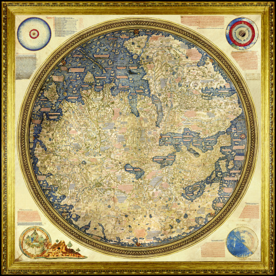


Mappamondo di Fra Mauro
[1450 circa - 230 x 230 cm circa - Biblioteca Nazionale Marciana di Venezia]
1 note
·
View note
Text
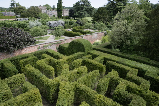
Labyrinth Or Maze? (2)
The history of #labyrinths and #mazes and why we confuse the two
Early and mediaeval Christians adopted two-dimensional labyrinths in their iconography, usually in the form of wall or floor decorations, the oldest known, at the Basilica of Reparatus in Orleansville in Algeria, dating from the 4th century AD. Their purpose is unclear, some suggesting that they depict the twists and turns that beset the Christian life, others that they map out a penitential…
View On WordPress
#Drych y Prif Oesedd#Hampton Court maze#Labyrinth#Longleat#Mappa Mundi#maze#mizmazes#Shepherd’s race#the Basilica of Reparatus#Theophilus Evans#Troy town
0 notes
Text
Mappa Mundi
This medieval vellum sheet's
where humankind’s geography,
history and destiny meet.
Christ, enthroned above the world,
surveys creation: the saved enter heaven,
the damned are dragged to hell.
Eden’s gates are firmly closed.
Observed by the serpent, Eve’s alone,
hand outstretched, no fruit enclosed.
Kim M. Russell, 1st May 2023
Image found on Wikimedia
It’s Monday and time to Quadrille with…

View On WordPress
0 notes
Video
youtube
#Mappa Mundi#Modern History TV#medieval#Hereford Cathedral#Jason Kingsley OBE#Jason Kingsley#this is so fascinating
0 notes
Text
This is great!
"The topologist's world map"
0 notes
Photo

2.4 x 2.4 meters, Fra Mauro's mappa mundi: the world's largest extant map from early modern Europe, 1450.
201 notes
·
View notes
Photo

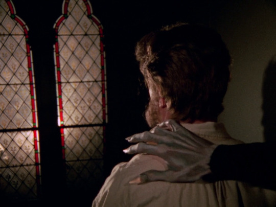
The Stalls of Barchester (Lawrence Gordon Clark, 1971)
“James had a genius for imbuing objects from the past with implacable malignity. The bronze whistle in “Whistle and I’ll Come to You”, the Saxon Crown in “A Warning to the Curious”, the Mappa Mundi in “Mr. Humphry’s Inheritance” and so on. Hitchcock claimed that his “Macguffin” could be anything or nothing so long as people were prepared to kill for it, and perhaps that’s why some of his films are compelling but ultimately empty constructs. James’ objects are truly frightening because they resonate with our deepest and oldest fears about what lurks in the darkness outside the comfort and light of the tribal campfire. A whistle blown could summon who knows what fears, or perhaps a terrifying storm, a crown buried in a coastal barrow was a sacred guardian against invasion and to remove it earns the ultimate punishment, and when Haynes sits in the Archdeacon’s throne in the choir stalls for the first time he puts his hand on the carved figure of a crouching cat that adorns his armrest, and his fate is sealed.” — Lawrence Gordon Clark, quoted in Yuletide Terror: Christmas Horror on Film and Television (2017), edited by Kier-La Janisse.
#the stalls of barchester#lawrence gordon clark#yuletide terror: christmas horror on film and television#kier la janisse#caps#w*#mr james christmas
109 notes
·
View notes
Text


mappae mundi in codici del Commentario all’Apocalisse
del Beato di Liebana
"un monaco della Spagna mozarabica (cioè la Spagna cristiana sotto dominazione araba) dell’VIII secolo. Costui è autore di un commentario illustrato dell’Apocalisse che venne copiato in moltissimi codici altomedievali. Rispetto al mappamondo T-O di Isidoro, il mappamondo di Beato di Liebana ha una forma più quadrato-rettangolare che rotonda: Asia e Africa sono molto meno distinte e soprattutto si nota l’aggiunta nell’estremità destra, cioè nella parte più lontana dell’Asia, di uno spicchio di Terra grossolanamente tagliato dal blocco continentale, con il quale si rappresentano gli antipodi, cioè le terre non abitate dagli uomini nell’altra parte del globo."
3 notes
·
View notes
Photo
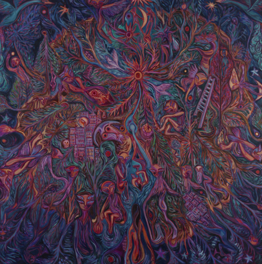
John Abell
Mappa Mundi (Lonely Planet Boy), 2022
Oil on canvas
71 notes
·
View notes
Note
“What other cultures call cotton candy”: candy floss! 🎡🎪🎠🎢 at the fun fair 😊 How many different names are your favourites called around the world? 🌎🌍🌏🗺 A Mappa Mundi of Delicious!
I know in some places it's Spun Sugar, but I don't know if that's US regional or international :D Readers, got any more names for cotton candy-candy floss-spun sugar?
211 notes
·
View notes
Text
Monopods
Monopods (also called sciapods, skiapods, skiapodes) were mythological dwarf-like creatures with a single, large foot extending from a leg centred in the middle of their bodies. The names monopod and skiapod (σκιάποδες) are both Greek, respectively meaning "one-foot" and "shadow-foot".

Monopods appear in Aristophanes' play The Birds, first performed in 414 BC. They are described by Pliny the Elder in his Natural History, where he reports travelers' stories from encounters or sightings of Monopods in India. Pliny remarks that they are first mentioned by Ctesias in his book Indika, a record of the view of Persians of India which only remains in fragments. Pliny describes Monopods like this:
He [Ctesias] speaks also of another race of men, who are known as Monocoli, who have only one leg, but are able to leap with surprising agility. The same people are also called Sciapodae, because they are in the habit of lying on their backs, during the time of the extreme heat, and protect themselves from the sun by the shade of their feet.
Philostratus mentions Skiapodes in his Life of Apollonius of Tyana, which was cited by Eusebius in his Treatise Against Hierocles. Apollonius of Tyana believes the Skiapodes live in India and Ethiopia, and asks the Indian sage Iarkhas about their existence.
St. Augustine (354–430) mentions the "Skiopodes" in The City of God, Book 16, Chapter 8 entitled "Whether Certain Monstrous Races of Men Are Derived From the Stock of Adam or Noah's Sons", and mentions that it is uncertain whether such creatures exist.
Reference to the legend continued into the Middle Ages, for example with Isidore of Seville in his Etymologiae, where he writes:
The race of Sciopodes are said to live in Ethiopia; they have only one leg, and are wonderfully speedy. The Greeks call them σκιαπόδες ("shade-footed ones") because when it is hot they lie on their backs on the ground and are shaded by the great size of their foot.
The Hereford Mappa Mundi, drawn c. 1300, shows a sciapod on one side of the world, as does a world map drawn by Beatus of Liébana (c. 730 – c. 800).
A race of the "One-Legged",or the "Uniped" was allegedly encountered by Thorfinn Karlsefni and his group of Icelandic settlers in North America in the early 11th century, according to the Saga of Erik the Red. The presence of "unipedes maritimi" in Greenland was marked on Claudius Clavus's map dated 1427.
According to the saga, Karlsefni Thorvald Eiriksson and others assembled a search party for Thorhall, and sailed around Kjalarnes and then south. After sailing for a long time, while moored on the south side of a west-flowing river, they were shot at by a one-footed man (einfœtingr), and Thorvald died from an arrow wound.
The saga goes on to relate that the party went northward and approached what they guessed to be Einfœtingaland ("Land of the One-Legged" or "Country of the Unipeds").
According to Carl A. P. Ruck, the Monopods's cited existence in India refers to the Vedic Aja Ekapad ("Not-born Single-foot"), an epithet for Soma. Since Soma is a botanical deity the single foot would represent the stem of an entheogenic plant or fungus.
John of Marignolli (1338–1353) provides another explanation of these creatures. Quote from his travels from India:
The truth is that no such people do exist as nations, though there may be an individual monster here and there. Nor is there any people at all such as has been invented, who have but one foot which they use to shade themselves withal. But as all the Indians commonly go naked, they are in the habit of carrying a thing like a little tent-roof on a cane handle, which they open out at will as a protection against sun or rain. This they call a chatyr; I brought one to Florence with me. And this it is which the poets have converted into a foot.
—
8 notes
·
View notes
Last Seen Blogs

chupakidstv1-blog
ChupaKids TV

livencespedes
Liven Céspedes (21 Ways Media)

rosa-de-bayahibe
• * 🌺 * •

penmeetspage
Worlds cross where pen meets page