#Ancient urban planning Dholavira
Text
Explore Dholavira - A 5000-year-old Harappan Gem in Gujarat
Explore the ancient Harappan city of Dholavira with Evoke Dholavira. Discover its sophisticated urban planning, artifacts, and the mysteries of a 5000-year-old civilization. Book your stay for a unique blend of history and luxury in the heart of Gujarat. Visit evokedholavira.com for more information and reservations.
#Dholavira archaeological site#Harappan civilization history#Luxury stays in Dholavira#Ancient city tours India#Evoke Dholavira bookings#Dholavira travel guide#Ancient urban planning Dholavira#Dholavira artifacts and inscriptions#Cultural tourism in Gujarat#Historical resorts in India
0 notes
Text
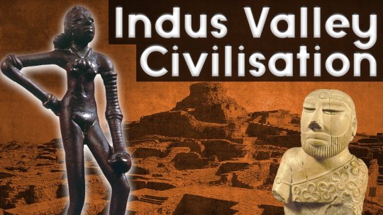
MODERN HISTORY
2ND BLOG _ The Indus Valley Civilization / HISTORICAL EVENT
The Indus Valley Civilization was one of the oldest urban civilizations, dating from 2500 BC to 1500 BC. Although research is still being done on how they handled the issue of water conservation in this interesting part of the world, some advanced water conservation and management practices can be named. In fact, the covered drains that run under the streets of the ruins of Mohenjodaro and Harappa show that their inhabitants were well versed in hygiene. The relevance that exists in relation to the problems of excessive water consumption and the events that occurred within this civilization are interestingly compatible, since at this point in the blog is where my theory is that in ancient times, water consumption was not as excessive as it is today, the reasons for this is not only because there was less population at that time, but because people knew how to distribute and appreciate the resources provided by the earth and they respected it very much.
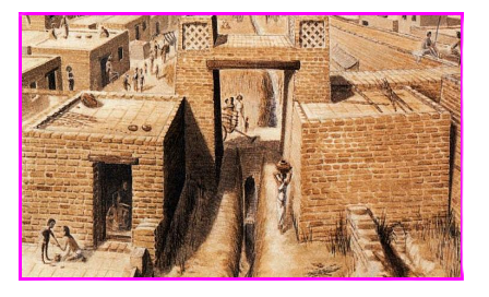
The Indus Valley Civilization, which flourished along the banks of the Indus River and other parts of western and northern India about 5,000 years ago, had one of the most sophisticated urban water supply and sanitation systems in the world. Ruins such as Mohenjo-Daro in Sindh and Dholavira in Gujarat had settlements with some of the most sophisticated sanitation systems in the ancient world. They included drainage canals, rainwater harvesting, and street sewers. Sewage was disposed of through underground drains built with precisely laid bricks, and an elaborate water management system with numerous reservoirs was established. In the drainage systems, the drains from the houses were connected to the wider public drains laid along the main streets. The drains had holes at regular intervals for cleaning and inspection. Water from bathrooms on the roofs and upper floors was carried through closed terracotta pipes or open chutes that emptied into the street drains.
Some of the cities of this civilization contributed in a certain way to the conservation of water, since they had their own irrigation systems that allowed the conservation of water in a better way. These cities are the following:
Dholavira: One of the oldest water´s harvesting systems is located about 130 km from Pune along Naneghat in the Western Ghats. A large number of cisterns were carved into the rocks to provide drinking water to the traders who traveled along this ancient trade route. Each fort in the area had its own water harvesting and storage system in the form of rock-cut cisterns, ponds, tanks and wells, which are still in use today. A large number of forts like Raigad had tanks that supplied water.
Western Rajasthan: In ancient times, houses in parts of western Rajasthan were built so that each had a water harvesting system on the roof. Rainwater from these roofs was channeled into underground tanks. This system can still be seen today in all the forts, palaces and houses of the region.
Jodhpur: The old city of Jodhpur has over 200 stepwells, built from around the 6th century as part of an incredibly sophisticated water architecture," he explains. During the little rain the region receives between June and September, water is diverted from canals built on the hilly outskirts of the city to man-made tanks, or talabs.
In addition, one of the main figures in water conservation in this civilization were the engineers and urban planners, who were in charge of drainage systems and so on. They were known to have extensive knowledge on how to conserve water.
The results obtained by this civilization in terms of water conservation are the different implementations they gave to water conservation related to the system they had to maintain cleanliness at the time of using the water resource. The effects they had on the future plans of water conservation are mainly positive, since it is well known that this civilization was an intelligent and organized one, that knew how to control its resources very well and how to improve day by day, but above all, to do it in peace with the environment.
If we want to go deeper into this topic of the Indus civilization and water conservation, let's make a connection with the present time. Actually, water conservation is so important especially in environmental topics that are given in schools or in those talks that are given in any convention, but the thing here is that how could it be possible? Well, the answer is because of the ancient civilization that paved the way for us and made it easier for us to continue to practice water conservation today.
To finish this blog, let's review everything about this historical event, basically the Indus Valley civilization makes it easier for actual people to organize well water and not make such a mistake when we have to preserve it in the right way. If we start to become aware of this whole problem and start to organize our resources in the best possible way like this civilization did, we can probably improve all over the world with this issue of conniving water for a better change in general.

13 notes
·
View notes
Text
Exploring Gujarat: Where Diversity Meets Beauty
Gujarat, a vibrant state on the western coast of India, is a tapestry of colors, cultures, and landscapes. From the arid beauty of its deserts to the majestic stature of its monuments, Gujarat offers a journey through time, nature, and spirituality. This article takes you through some of Gujarat’s most captivating destinations, each telling a story of its own.
Nadabet: A Peek into Border Life
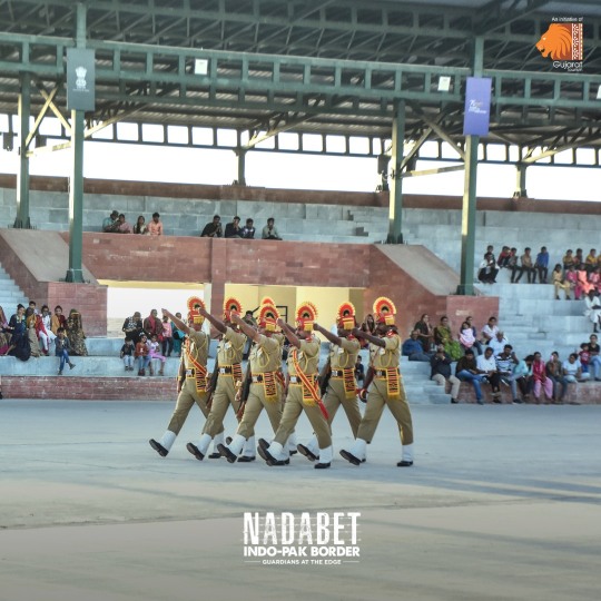
Nestled on the India-Pakistan border, Nadabet is more than just a geographical landmark; it's a testament to the spirit of nationalism. The recently developed 'Seema Darshan' project allows visitors to experience the life of BSF soldiers guarding our borders. It’s a unique blend of patriotism with tourism, offering an insightful peek into the rigorous lives of India's border security forces. The area also showcases a captivating desert ecosystem, making it a must-visit for those interested in the confluence of nature and national pride.
Rann Utsav: A Cultural Mosaic
The Rann Utsav is an annual festival that transforms the stark white salt marshes of the Kutch into a canvas of vibrant colors and lively festivities. This cultural extravaganza, spanning three months during the winter, celebrates the rich heritage and traditions of Gujarat. Visitors can indulge in folk dances, music, handicrafts, and sumptuous local cuisine, all while staying in traditional Bhungas (mud houses) or luxurious tents. Rann Utsav-The Tent City provides luxurious tents and amenities, ensuring that guests enjoy the festival’s vibrancy in comfort and style.
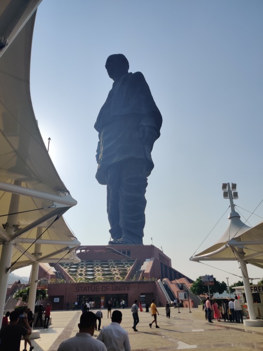
Statue of Unity: An Architectural Marvel
The Statue of Unity, commemorating Sardar Vallabhbhai Patel, is not only a marvel of engineering but a beacon of India's unity. Surrounding the statue, visitors can explore the Valley of Flowers, a vibrant spread of native flora, and the Sardar Sarovar Dam, showcasing India's engineering prowess. The viewing gallery at 153 meters provides a breathtaking panorama of the surrounding landscape, making it a must-visit landmark in Gujarat. Statue of Unity Tent City-1 offers a luxurious stay, where visitors can relax after exploring the statue and its surroundings, ensuring a comfortable and enriching experience.
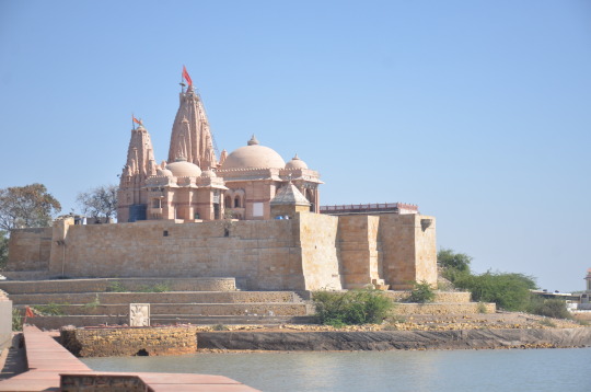
Dholavira: A Glimpse into Ancient Civilization
Dholavira, a significant archaeological site of the Indus Valley Civilization, offers a fascinating glimpse into ancient urban planning and culture. Evoke Dholavira provides a comfortable base to explore these ancient ruins, blending modern amenities with the rustic charm of the surrounding landscape. It's an invitation to step back in time while enjoying contemporary comforts.
Sands of Mandvi: Beaches and Royal Legacies
Mandvi, known for its pristine beaches and the historic Vijay Vilas Palace, offers a blend of relaxation and royal heritage. The soft sands and clear waters of Mandvi Beach provide a tranquil retreat, while the architectural elegance of Vijay Vilas Palace, showcasing traditional Kutchi craftsmanship, transports visitors to the era of kings and queens. The shipbuilding yard, continuing the centuries-old tradition of wooden shipbuilding, adds to the charm of this coastal town.
Shivrajpur: Crystal Waters and Serene Beaches
Shivrajpur Beach, with its crystal-clear waters and white sands, is a hidden gem along Gujarat's coastline. Recognized with a Blue Flag certification, the beach ensures high environmental and quality standards, making it a perfect spot for a family outing. The beach is also a hub for water sports enthusiasts, offering activities like snorkeling and scuba diving to explore the vibrant marine life.
Conclusion
Gujarat is a land of diversity, where every corner tells a different story, every landscape paints a different picture, and every tradition sings a different tune. From the patriotic vibes of Nadabet to the ancient secrets of Dholavira, the cultural festivity of Rann Utsav to the architectural grandeur of the Statue of Unity, the serene beaches of Mandvi and Shivrajpur to the royal legacies, Gujarat beckons travelers with its myriad hues of beauty and culture. It’s a journey where the diversity of India comes alive, inviting you to explore, experience, and cherish.
#Nadabet Seema Darshan#Nadabet Seema Darshan Project#Nadabet Seema Darshan Time#Tourist Places In Gujarat#Places To Visit In Gujarat#Indo Pak Border In Gujarat#Nadabet Online Booking#Gujarat Tourist Places#gujarat tourism
0 notes
Photo
The Mystery of the World’s Oldest Billboard
The 5,000-year-old port city of Dholavira can be found on an island in the salt flats of the Great Rann of Kutch on India’s western edge. It has been described as “one of the best preserved urban settlements from the period in Southeast Asia” by UNESCO. Researchers have found step-wells and reservoirs that formed a sophisticated water management system, the remains of ancient streets and boulevards lined by houses of varying sizes, the ruins of a jewelry workshop, and one of the most remarkable discoveries in Indian archeology: what is believed to be the world’s oldest billboard The billboard—typically called the Dholavira signboard—was discovered when a team from the Archaeological Survey of India began excavating the southern center of the Indus Valley Civilization in the 1990s. At Dholavira’s northern gate, archaeologists came across two chambers flanking the gate on either side. These chambers looked like storage spaces. And like most storerooms, they were an absolute mess. The team in the western chamber was gently clearing fallen debris and stones that hadn’t been touched for thousands of years when glints of white became visible. After more careful excavation, they found ten large symbols, each about 15 inches tall and made out of multiple pieces of white gypsum, a material that’s used in drywall today. Archaeologists also found evidence of decomposed wood surrounding the symbols. These clues led the researchers to conclude that the symbols were part of a billboard. The bright white gypsum would have made the symbols visible from a distance even at night, as torch light reflected off the mineral, while the surrounding wood would have supported the symbols. R. S. Bisht, who led the team that excavated the site throughout the 1990s and early 2000s, believes that the Dholavira signboard sat atop the largest of the ancient city’s five entrances. Bisht says, “the wooden board was 3.5 meters [11 feet] long and the threshold of the northern gate was also 3.5 meters [11 feet] wide. It seems that it was bolted on the facade of the northern gate and could have been seen from the lower and middle town.” Researchers wondered why the sign was in a chamber next to the northern gate rather than on it. But Bisht believes that an earthquake, a common occurrence in the area, could have been responsible for dislodging the sign, after which the citizens of Dholavira carefully moved it to a storeroom next to the gate. Still, one big mystery remains: What did the billboard say? The symbols are remarkably well preserved, perhaps because the billboard was lying face down for thousands of years, the wood of the board protecting the gypsum symbols from the environment. But they are written in the script of the Indus Valley Civilization, which has not yet been deciphered, so no one knows what information was displayed so prominently in the city. The Dholavira signboard is now in the collection at the National Museum in New Delhi, though it is not on display because of preservation concerns. It remains an object of ongoing research as one of the longest inscriptions in the Indus or Harappan script. Until the script is deciphered, everything that is known about the people and culture of the Indus Valley Civilization comes from archaeological evidence. From its earliest beginnings as the neolithic Mehrgarh culture over 9,000 years ago, the Indus Valley Civilization thrived for thousands of years across the lands of modern-day Afghanistan, Pakistan, and India. The people traded with the civilizations of Mesopotamia and China and built settlements with better-planned drainage systems than some modern cities. Yet, around 4,000 years ago, they abandoned their cities and writing and disappeared. “The Indus Valley people could not get basic needs like fresh water for irrigation and drinking,” says Mahesh Thakkar, professor of geology and head of the Department of Earth and Environmental Science at K.S.K.V. Kachchh University in Bhuj—the closest major city to Dholavira. “Slow climate change over time led them to migrate to the fertile and perennial river basins of the Ganga and Yamuna, leaving their old urban centers abandoned.” The climate events that caused the people of Dholavira to abandon their city were not caused by humans but while we cannot decipher what was written on the sign that the people of Dholavira left forgotten in a storeroom before leaving their city for good, its message about the dangers of climate change is clear.
https://www.atlasobscura.com/articles/oldest-billboard-in-world
0 notes
Text
Indus Valley Civilization (IVC)
The background of India began with the beginning of Indus Valley Civilization (IVC), also called the Harappan Civilization.
It flourished between 2,500 BC in the western region of South Asia, in modern Pakistan as well as Western India.
In the Indus Valley was the home of The most ancient of four urban cultures that comprised Egypt, Mesopotamia, India and China.
In 1920s In the 1920s, in the 1920s, Archaeological Department of India carried excavations within the Indus valley. The ruins of two cities were discovered. Mohenjodaro as well as Harappa were found.
In the year 1924 John Marshall, Director General of the ASI made public that he had discovered of a new civilization within the Indus valley to the rest of the world.
Phases of IVC
Three types IVC are: IVC are:
It is believed that the Early Harappan Phase is related to the Hakra Phase, found in the Ghaggar Hakra River Valley.
The earliest instances from writing in Indus script go back to 3000 BC.
This phase is marked by central authority and an increasing urban lifestyle.
trade networks were in place and there is evidence regarding an increase in the cultivation of various crops. Sesame seeds, peas dates, cotton and many others were cultivated at the time.
Kot Diji symbolizes the period that leads to Mature Harappan Phase.
In 2600 BC in the 2600 BC period, 2600 BC, the Indus Valley Civilization had moved into an maturing stage.
The first Harappan communities were transforming into cities of immense size, like Harappa as well as Mohenjodaro within Pakistan as well as Lothal within India.
during the Early Harappan Phase between 3300 and 2600 BCE,
the mature Harappan Phase from 2600 to 1900 BCE and
during the Late Harappan Phase between 1900 and 1300 BCE.
The signs of the slow decrease in the Indus The signs of a gradual decline in the Indus Valley Civilization is thought to have started in the 1800s BC and, by 1700 BC many cities had been abandoned.
But, it is possible to observe the different aspects of the ancient Indus Valley Civilization throughout the subsequent cultures.
The archaeological evidence indicates the existence in archaeological evidence that suggests the existence of Late Harappan culture till 1000-900 BC.
Town Planning and Structures
Harappan culture was distinguished by its town planning system. Harappan style of living has been distinctive by its method of city planning.
Harappa and Mohenjodaro had their own acropolis or citadel that could have been used by the upper class.
In each city was below the citadels of each city lay a lower town with brick homes which were used by people of the common.
The interesting aspect of the layout of the homes in the city is the fact that they were arranged according to the grid arrangement.
Granaries were a major element of Harappan cities.
The burning of bricks in Harappan cities is remarkable due to the fact that in the current constructions of Egypt the majority of dried bricks were utilized.
Its water drainage scheme in Mohenjodaro was awe-inspiring.
In most cities, each house, small or large included a backyard and bathroom..
In Kalibangan there were many homes with bathrooms.
In places like Dholavira or Lothal (Gujarat) The entire town was secured, and the parts of the town were separated from each other by wall.
Agriculture
Harappan villages Harappan communities, mostly situated near the floodplains provided enough grain for food.
Barley, wheat sesame, peas chickpea, lentil, and mustard were also produced. Millets were also discovered from places in Gujarat. Although rice was uncommon.
Indus people were the Indus tribe were among the first to develop cotton..
Although the widespread use of agriculture is evident from the presence of grains however, it is difficult to trace the actual practices in agriculture.
Seals' representations and Terracotta sculptures suggest it was the case that bulls were used for ploughing. bull was a popular animal, and archaeologists infer that the oxen were also used for plowing.
The majority of Harappan sites are situated in semi-arid areas, where irrigation was likely required for agricultural purposes.
Canals are found in Harappa, which is located at Harappan website in Shortughai in Afghanistan however, they are not found located in Punjab as well as Sindh.
While the Harappans practiced agriculture, animals were also raised on a massive scale.
The evidence of the horse originates from a very superficial level of Mohenjodaro as well as an unproven terracotta statue from Lothal. However, there is no evidence that suggests the Harappan tradition was certainly not entirely horse to be centered.
Economy
The significance of trade in the daily life of Indus people is evident by the presence of seals as well as uniform scripts, and weights and measurements over a large space.
Harappans conducted a significant trading in metal, stone and shells, etc.
The metal currency was never utilized and trade was conducted via barter systems.
They practiced navigation along shores of the Arabian Sea.
They set up the commercial colony the northern region of Afghanistan which , it appears, helped commerce to Central Asia.
They also conducted commerce with the people of the land that was the Tigris and the Euphrates.
Harappans were involved in long distance commerce with lapis-lazuli and this may have helped in the social standing for the elite class.
Crafts
The Harappans were well familiar with the manufacture and usage of Bronze.
Copper was sourced through in the Khetri Copper mines in Rajasthan along with Tin may have been brought by Afghanistan.
Impressions of textiles were also discovered on a variety of objects.
Massive brick structures suggest it was building bricks was a major craft. It also demonstrates to the fact that masons were masons as a distinct class.
The Harappans were adept at boat-making, beads making, and sealing. The manufacture of terracotta was also the most important art.
Goldsmiths created jewellery made of gold, silver along with precious stones.
The wheel of the potter was working at full capacity and the Harappans made their unique pottery that was smooth and shiny.
Institutions
A few writings have been found within the Indus valley and scholars haven't been able to understand the Indus script to date.
In the end that there is difficult to comprehend how the government functions as well as the institutions that were part of Indus Valley Civilization. Indus Valley Civilization.
There are no temples were found in all Harappan sites. Thus the possibility of having priests in charge of Harappa is eliminated.
Harappa may have been controlled by a group that included merchants.
If we are looking for a power centre or images of people in positions of power, archeological records do not provide immediate solutions .
A few archaeologists are of the belief that Harappan society was ruled by no ruling class and that everyone had equal rights.
Another theory suggests that there was no one ruler and that there was several rulers from each of the cities.
Religion
In Harappa many terracotta figures of women There have been some discoveries. In one figure, a plant appears to be growing out of the embryo of the woman.
The male god is depicted on a seal by three heads with horns, depicted in the sitting position of yoga yogis.
Numerous images of the female sex and phallus organs constructed from stone have been discovered.
The inhabitants of Indus region worshipped trees. Indus Region also worshipped animals and trees..
The most famous of them all is the one-horned unicorn which can be distinguished as a rhinoceros. The second most important was the bull with the hump..
Amulets are also found in large quantities.
Harappans therefore saw the earth as an fertility god and revered her in the same way that they worshiped the Egyptians revered Isis, the Nile goddess Isis.
The god is surrounded an elephant or a tiger, rhinoceros, and an animal on his throne below. On his feet, there are two deer.The God depicted is identified with the title Pushupati Mahadeva.
Decline of the Indus Valley Civilization
The IVC was a decline in the 1800 BCE however the exact motives behind its demise are still being debated.
One theory suggests that Indo-European is a tribe i.e. Aryans were encroached upon and defeated and conquered the IVC.
However some scholars consider natural elements is the reason for the decline in the IVC.
It is possible that there were radical shifts in course of the rivers, which might have resulted in flooding of the regions that produced food.
Due to the combination with these causes, there was a gradual, but inevitable decline of IVC.
In the later civilizations, various aspects that are part of IVC are discovered that suggest that civilization did not vanish in a flash because of an invasion.
The natural causes could be geo-climatic and geological.
The theory is that the Indus Valley region was subject to many destructive tectonic events that led to earthquakes. These also altered the course of rivers, or dried them out.
Another reason could be shifts in patterns of rain.
0 notes
Text
Indus Valley Civilization - Points to Remember for UPSC Civil Services Exam
The Indus Valley Civilization (IVC) was a Bronze Age civilization (2600-1900 BCE) extending from what today is North-east Afghanistan to Pakistan and North-west India. It flourished in the basins of the Indus River, one of the major rivers of Asia, and the Ghaggar-Hakra River, that once coursed through North-west India and Eastern Pakistan.
The Early Harappan Period
The characteristics of the early Harappan period are:
Amri -> Stone and mud brick houses; Granaries; fortification
Kot-Diji -> decorative pottery; fortification
Mehrgarh -> prosperous town; use of lapis-lazuli; seals;
Kalibangan -> mud bricks houses; pottery in different shapes; ploughed field surface.
Emergence of the Harappan Civilization
Some of the reasons that may have led to the emergence of the Harappan civilization are:
· The Existence of many agricultural groups and pastoral nomadic communities were living in close contact with each other.
· This must have led to conflict among them.
· The agricultural communities would have fought with each other for the control of more fertile tracts of land which is the possible reason for defensive walls.
· This led to emergence of Mature Harappan period.
Features of Harappan Civilization
The Harappan society was characterized by the presence of
· specialized craftsmen,
· long distance trade,
· the existence of rich and poor people and
· the presence of kings.
The Harappan communities staying in Rajasthan, Punjab or Sindh may have been using the same sets of weights and measures.
The copper-bronze tools used by them were also uniform in design, shape and size, the bricks they used had a proportion 4:2:1.
The towns were characterized by uniformities in the planning of the buildings, citadels etc.
The seals, shell(shankh) bangles, carnelian beads and the disc beads of steatite were also uniformly designed in the entire geographical space covered by the cities of the Harappan Civilization.
Most of the time a Harappan site is identified by the use of a pinkish pottery with bright red slip. This pottery had standard representations of trees, animals, birds and geometric motifs in black.
It is the oldest civilization of India and also known as the first Urbanization.
After independence it was called “Harappan Civilization”. As Harappa was the first largest city excavated.
Important Centers
During the civilization there were around 1000 cities.
Harappa
It was the first site to be excavated.
Substantial section of population was engaged in activities related to administration, trade, craft work or religion.
It was located in the midst of some important trade routes of the world.
Mohenjodaro
It is the largest site of Harappan Civilization. It is also called “Mound of the Dead”.
It is one of the world’s earliest major urban settlements.
Kalibangan
It has the largest concentration of the Harappan Civilization.
Lothal
It is located in the coastal flats if the Gulf of Cambay.
It is called as the dockyard of the Harappan times.
Dholavira
Located in the Rann of Kannch is most recently excavated place.
Ancient History adds at least 4 – 5 questions in the UPSC Prelims. UPSC has been focussing on Art & Culture which is a part of Ancient History’s syllabus. Many aspirants ignore Ancient History. History is a continuous flow of events. In order to better understand Modern History, we need to have clarity about Ancient History also.
The technology today offers a lot more than one can digest therefore apart from offline sources; always make use of online sources that are available over the web. Go through the latest information offered by many online learning websites. Unoreads is one of the top destinations for Online Learning Platforms where the expert team envision empowering young and inquisitive minds to choose the right path for them by learning from our experience created and conducted by the experts of the industry.
0 notes
Text
Kutch Trip Report 2021
2800 km in 9 days that is Kutch trip 2021 for us. Started as only 4 persons while planning, it took off with 8 persons in two cars one Renault Duster and the other Honda Jazz. It was to be Noel, Commander, me and Meera Madam from the Spiti Team. But overhearing our conversation, my younger son said I will also come. Navin from Delhi opted to join, then my son said let’s go in our car. That gave us some leverage. Anandhi my wife said I will also come. Biren and Madhavi joined from Vadodara. Unfortunately, Navin could not join due to Covid. Hence, it was 8 persons in two cars. I insisted on RT-PCR due to Covid so that there should not be any hiccups when we cross the state border either way, which was agreed upon.
Everything started rolling in, a group was formed to share the ideas, places to see, etc. Few meetings took place in virtually. It was loosely decided to have a 9 day trip. Of which first 5 days were planned and booked. Rest of the bookings, it was agreed to go as it comes. The plan which was agreed upon went like this.
Kevadia, Ahmedabad, Patan, Dasada, Dhordo, Bhuj/Nakhatrana, Lakhpat, Narayan Sarovar, Mandvi, Vadodara and Dandi. Biren insisted on staying with him on last day at Vadodara.
A week before D-day, it was finalised with a halt at Kevadia, stay in outskirts of Vadodara, pass Ahmedabad to Patan, and 2 night halts at Dasada, 2 night homestay at Chobari. That was upto 1st morning. At Chobari, Ramji Meriya, the owner of Nature Zone referred us to Jugal Tiwari the owner of Centre for Desert and Ocean at Nakhatrana.
Off went we 3 from Kalyan west on 24.2.2021, picked up Meera Madam from Kalyan east in the early morning and proceeded to meet the other group at Khaman junction on the highway. Noel and Commander started from Powai and reached there.
Day-1
Kevadia
After breakfast at Hotel Ahura, went to Kevadiya via Navsari-Rajpipla and reached Statue of Unity. We reached via Kevadiya railway station road and Noel reached the other way. Parked our cars at Valley of Flowers car parking. You can walk to the nearest gate also. Plenty of buses run for visitors to reach the gate, of course free of cost at frequent interval. As we have booked the tickets online, we showed the booking in our mobile and went inside. There are two types of tickets one for the gallery and the other to go in lift upto a certain level inside the statue to see the view from above. You may require atleast 3-4 hours to see around. Evening sunset near the dam and light show on the statue after sunset are additional attractions. Then we went to Vadodara outskirts and stayed in Hotel Apple Grand. (a nice hotel on the highway)
The 182-metre (600 feet aprox.) statue is dedicated to Sardar Vallabhbhai Patel, the architect of independent India. The colossal monument towers over River Narmada and overlooks the vast surrounds and the river basin and the sprawling Sardar Sarovar dam. The Sardar Sarovar Dam is the third highest concrete dam (163 metres) in India after Bhakra (226 metres) in Himachal Pradesh and Lakhwar (192 metres) in Uttar Pradesh. A Light and Sound show using laser technology projected on the Statue of Unity takes place every evening except Monday. For further details about the Statue of Unity click here
Day-2
Biren and Madhavi joined us in the morning. At breakfast, we decided to skip Sabarmati as going in Ahmedabad would delay our journey. Instead we went to Adalaj Stepwell.
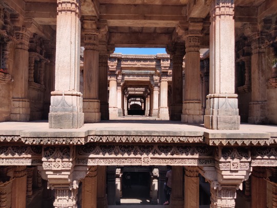
Adalaj Stepwell
The flamboyant 15th-century stepwell, with intricate carvings on the pillars that support the five storeys are mostly intact; the beams work as pit stops for pigeons flying in and out and the structure still leaves jaws dropped for swarms of people. The step-well represents the Indo-Islamic fusion architecture that percolated through the many stepwells of the period. The opening in the ceilings above the landing allows light and air to enter the octagonal well, but direct sunlight never touches the steps except at noon. It is said that the temperature inside the well is six degrees cooler than outside. The stepwell has three entrances. The stairs lead to an underground storey, which has an octagonal opening on top. The walls are covered in ornamental carvings with mythological and village scenes. You can read about it more here
Rani-ki-vav, Patan
Next stop was Patan, the world heritage site of Rani-ki-Vav. This is one of the oldest and finest stepwells in Gujarat and is remarkably preserved. Steps lead down through multiple levels with lines of carved pillars and more than 800 sculptures, mostly on Vishnu-avatar themes, as well as striking geometric patterns. The stepwell is made in the form of an inverted temple. It showcases superior craftsmanship of the era, and the unique Maru-Gurjara architectural style. The stepwell was built in 1063 by Rani Udayamati of the Chaulukya Dynasty to commemorate her husband, Bhimdev I. The stepwell was commissioned in 1063 and was completed after 20 years. Archeologists Henry Cousens and James Burgess visited it in 1890s when it was completely buried under silt and only the shaft and few pillars were visible. The stepwell was rediscovered in 1940s, and the Archeological Survey of India restored it in 1980s. The stepwell has been listed as one of UNESCO's World Heritage Sites since 2014. Read more here
Sun Temple, Modhera
The guide we hired here told us to go to Modhera also. So we went to Modhera before the close of the site for the day. Modhera is an ideal destination for being away from the hustle-bustle of city life for a day. The unruffled peaceful landscape and the majestically welcoming temple complex will ensure to take you away from the mundane routines of daily. As you enter the historical complex, you first come across the magnificent kund known as the Ramakund, built in rectangular shape containing 108 shrines to various gods and demi-gods. There are three main shrines positioned on the three sides of the kund, dedicated to Ganesh and Vishnu and an image of Lord Shiva dancing the ‘tandav’ facing the temple of the sun which covers the fourth side. The twelve representations carved on the pillars represent the sun according to the twelve months. The statue of the sun god no longer exists. More about here

Reached Rann Riders, Dasada, Little Rann of Kutch in the night. During the night you can miss the sign board, while reaching advised to go slow so that you can take a proper turn to reach the resort. We met Cyclist Brajesh Sharma who was going live on YouTube from the Nature Zone. He is on All India Tour on cycle to create awareness about dangers of using plastic in general and single use plastic in particular. He regularly interacts with the schools, colleges on his tour which he started a year back. Follow him here
Day-3
Little Rann of Kutch
Morning after breakfast, went for the dry land safari in the Wild Ass Sanctuary and wet land safari in the evening. Being the world’s only natural habitat for wild ass, the sanctuary of course draws people to watch these magnificent creatures. However, the sanctuary harbours a large variety of bird population. The Rann was a shallow part of the Gulf of Kutch earlier. It is formed through the process of siltation of marine estuary. During monsoon, the Rann becomes a vast shallow sheet of water which dries up by October, November. Flamingos, Pelicans, Spoonbills, Glossy Ibis and Painted Storks etc were seen by us. We saw Brahminy Duck, Sandgrouse, etc. also.
Day-4
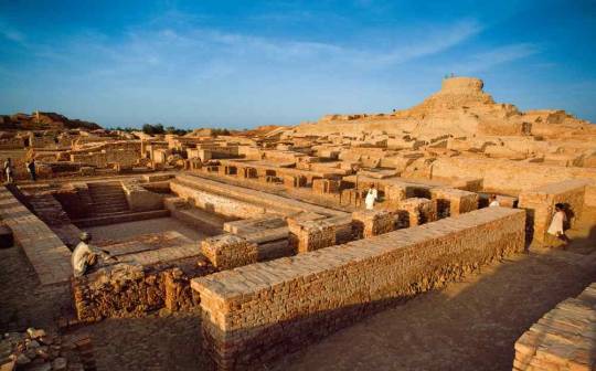
Left for Dholavira for Harappan Excavation another UNESCO World Heritage site. This was the highlight of the trip. As all you know, every such trip has a highlight and a place worth visiting, a lifetime achievement. Dholavira was one such place. You are reminded of the advance techniques used by people more than 4500 years ago. You will not believe until you see such place. Personally, I feel what you are taught in schools about history is nothing when you visit such places and hear from government guides.
Dholavira
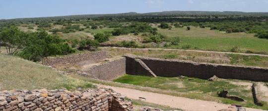
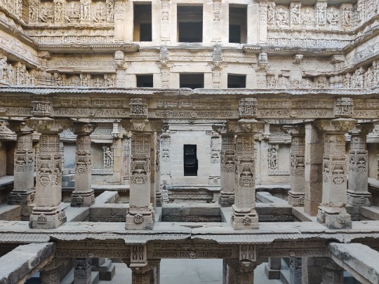
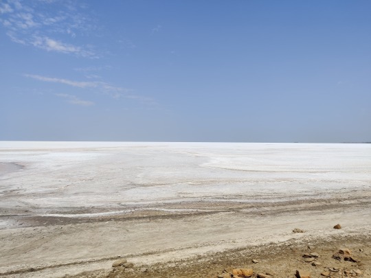
Dholavira is the most remarkable excavations of the Indus Valley Civilization or Harappan culture, dating back to 4500 years ago. What Dholavira offers you, in the intense environment that comes with being surrounded by the Great Rann of Kutch, is a unique insight into the pioneering Harappan mind, with one of the world’s earliest and best planned water conservation systems and what might be the world’s first signboards, written in ancient Indus script.
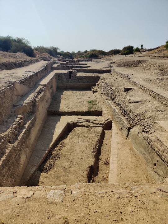
The excavation also tells the story of the 7 stages of the civilization, from development to maturity to decay, the last of which hints at a strange piece of history, with more questions than answers. After the peak of the civilization Dholavira was temporarily abandoned, after which it seems that the settlers returned with a markedly de-urbanized culture. There are hints that they willingly chose to simplify their lives, rather than try to ride the collapse of their once glorified civilization. Here, on the ruins, you will have a chance to contemplate what progress and civilization mean and what, if anything, is truly permanent.
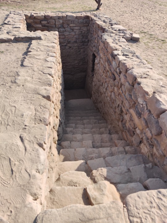
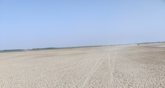
Dholavira, known locally as Kotada (large fort), sprawls over 100 hectares of semi-arid land at the north-west corner of the island of Khadir. It is one of the islands in the Great Rann of Kutch that remain above the flood-plains in months when the rest of the desert is submerged by the monsoon. Dholavira has two seasonal nallahs, or streams: Mansar in the north, and Manhar in the south. The journey to Dholavira itself is beautiful, taking you through the saline desert plains of the Great Rann, where you can spot wildlife such as chinkara, nilgai, flamingos and other bird life.
The site was unearthed by the Archeological Survey of India (ASI) in 1967, but has been systematically excavated only since 1990. It has a museum where all the artefacts are on display. Visit this website for more information.
Chobari
We started for Chobari, Nature Zone, our final stop of the day. The google map shows the wrong route at the last leg. But follow your instincts and go, as the people nearby are helpful. Ashwath drove through a village and people guided properly. When in the map it was showing the homestay is just across, I told him just take a turn instead of going ahead. Just then, I noticed a board showing the way. So, we went first, as the other car followed the google map and was helped by Ramji by sending a person to show the way. It is very difficult in the night and if you are new in these areas.
Meriya Nature Zone is a homestay and bookings can be made through personal contacts. It is yet to be on internet. The homestay is very good with basic amenities. As mobile network is available, no worries about internet connection. Ekal Rann is nearby and the full moon with Rann in background is something to be experienced. For bird lovers, the homestay itself is a heaven as Maharashtra’s state bird Yellow footed Green Pigeon, peacock, red vented bulbul, kingfisher, Domicile’s crane, etc are plenty. Just outside the homestay, there is a water body, where lot of coots, cormorants, ducks, shag, etc can be seen.
Day-5
Ekal Rann
Noel and others went for nearby bird watching where hordes of peacock, common cranes, calves feeding takes place and came back. The other group enjoyed the bird watching and village experience chitchatting under the tree in the homestay. As we have not decided about our further stay at Nakhatrana/Bhuj, Ramji Meriya suggested us Jugal Tiwari at Nakhatrana. We finalised the stay at Nakhatrana, Centre for Desert and Ocean (CEDO) for two nights. In the evening we went to Ekal Rann for sunset and full moon. We saw flamingos and cranes in thousands. The slushy road in between leads to Dholavira but only when it dries. Ramji was telling that due to excessive rains this year, it has not dried up. He also remembered his pioneering effort of bike rally from Ekal to Dholavira and back.
Day-6
Bhuj
After breakfast, we started off to Bhuj, and straight went to Aina Mahal but unfortunately, we reached around 12.30 pm. It is closed between 11.45 am and 3.00 pm. Then, Noel suggested to go to his friend’s hotel (Hotel Annapurna, near Bhid Gate). We thought of getting our RT-PCR done and enquired with Gor and Jugal Tiwari and agreed to do it in Bhuj before proceeding further to Mandvi and then to Nakhatrana. Bhagat lab, Bhuj does the RT-PCR in Bhuj.
Mandvi Beach
We then went to Mandvi beach and spent time. There must be some other point where seagull, spoon bill etc, are plenty. The beach point is very crowded with camel ride, boat ride, joy ride etc. and bustling with lot of people. We were wondering where this corona went?

Reached Moti-Virani village, where CEDO is situated and here came to know about Jugal Tiwari is ex. BNHS person. He was also pleasantly surprised to know about us being BNHS members. The booking at CEDO is through internet only and some times through contacts known to him. In our case Ramji Meriya. No bookings on go and knock.
Day-7
Lakhpat, Narayan Sarovar
Mata-no-Madh, Ashapura Temple
After breakfast, we started for Lakhpat the fort town. On our way we stopped at the Mata-No-Madh Ashapura Temple. This shrine is steeped in antiquity as far as its origin is concerned. Today there is no trace of any ancient records or writings which give any indications of the beginning of worship at this shrine. One fact firmly stands out that this deity was very much there in 9th century AD when the Samma clan of Rajputs from Sindh first entered western, or more correctly, north-western Kutch. They were followed in the later centuries by more families or this clan which eventually established them in the region and one of their line got control of the whole state of Kutch in the beginning of the 16th century. Then we went to Siyot Caves. It is a small Buddhist cave as the name suggests. From Siyot to Lakhpat, the road after passing a village was only bushes and mud road. Though the google map shows it as Siyot-Lakhpat Road, it is a challenge to drive on this road which joins the Gaduli-Lakhpat Road at the end.
Lakhpat
Lakhpat Fort with a walled fort, was an important coastal trade node in the 18th century. At the mouth of the Kori creek, the large fort walls still offer testimony to a short but glorious past. One can climb the fort rampart, the only remaining structure of the fort, and look over at the placid sea. This spot is particularly stunning at sunset. Within the fort walls, also lies a 16th century gurdwara. It is believed that Guru Nanak stopped here twice during his second (1506–1513) and fourth (1519–1521) missionary journey called Udasis. The gurdwara is a soothing spot for travellers. The soft hymns play constantly in the background, as travellers visit the ancient Sikh place of worship to see relics like wooden footwear, palkhi (palanquin), manuscripts and markings of two important heads of Udasi sect. We had prasad at the Gurudwara Langar.
More than 200 years old, the fort is named after Rao Lakha, who ruled in Sindh about the middle of the thirteenth century. It fell to ruins through the century, as trade depleted, and the people in the town migrated to fairer pastures.
Narayan Sarovar
Narayan Sarovar Temple has great spiritual significance. This is one of the 5 holy lakes of Hinduism, along with Mansarovar in Tibet, Pampa in Karnataka, Bhuvaneshwar in Orissa and Pushkar in Rajasthan, and is considered a coveted place for a holy dip. The origin of Narayan Sarovar dates back to the Puranas. It is said that there was a drought in the region, and Lord Vishnu appeared in response to ardent prayers by sages. When he touched the land with his toe, a lake was immediately created, alleviating the locals from their misery. An adjoining temple built by the wife of Maharao Desalji features shrines of Shri Trikamraiji, Laxminarayan, Govardhannathji, Dwarkanath, Adinarayan, Ranchodraiji and Laxmiji. Madhavi was excited to know about Vallabhacharya, who had baithak at this place. She interacted with the pujari of the temple to know more about it.
A short drive from here, the Koteshwar Mahadev Temple is a grand sandstone structure that overlooks a marshy sea. Shrines dedicated to Shiva and Ganesha are the highlights here. Koteshwar Temple, at a place where the immensity of dry land meets the incomprehensible vastness of the sea. It is the last outpost of human construction and the temple at the westernmost limit of India. The story of Koteshwar begins with Ravana, who won a boon from Lord Shiva for an outstanding display of piety. This boon was the gift of a Shiva linga of great spiritual power, but which Ravana, in his arrogant haste, accidentally dropped and it fell to earth at Koteshwar. To punish Ravana for his carelessness, the linga turned into a thousand identical copies (some versions of the story say ten thousand, some a million; suffice to say it was quite a lot.) Unable to distinguish the original, Ravana grabbed one and departed, leaving the original one here, around which Koteshwar Temple was built. Visitors can see the temple, walk along the beach and on a clear night, even see the glow of light from Karachi, Pakistan, on the north-western horizon. One more observation was that the flag is so long that it touches almost the sides. Never seen temple flag so long.
On our way back, we were looking for the tropic of cancer line which we could not find while going. To our delight, we found the board but the markings on the road is not at all visible may be due to asphalting of roads and ignorance of the contractor who laid the road.
We skipped going to Nirona village for award winning rogan artistes, bell makers, Lacquer works due to paucity of time.
Day-8
We started after our breakfast for Vadodara. Wait. Jugal Tiwari wanted to show us his fossil collections which was spellbound. He explained patiently and offered his help those students for their academic purpose. He also showed us the bell works and rogan art which he sells to guests as promotion of cultural appreciation. After exchanging pleasantries, we left for Biren’s house. The drive was a long one. We took a different route in which the road was not at all good as compared to arterial roads. Hence, we reached Vadodara at least 30-40 minutes after they reached. Noel went to his daughter in law’s place. We had a on the go Vadodara darshan in Biren’s vehicle. Meera Madam revisited her student days. We purchased some sweets and savouries for our contacts and colleagues in Mumbai. Else you will be stuck for response for it will be like Returned and had dinner at Biren’s house.
Day-9
Left early around 7 am. Biren dropped Commander and Meera at the designated spot to meet Noel. Transferred the luggages accordingly. Off we went to Dandi.
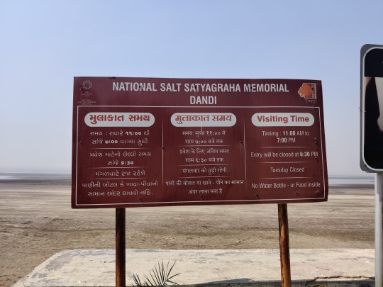
Dandi
The 'National Salt Satyagraha Memorial', Dandi, is conceived as an experiential journey recreating the spirit and the energy of the 1930 Dandi March led by Mahatma Gandhi and 80 of his fellow Satyagrahis, taking the visitors to the Monument step-by-step in order to visualize and understand the history of the historic Salt March and the methodology of Satyagraha, which finally led to India’s Independence. As Noel asked us to visit his factory at Vasai, off we went from Dandi to Vasai. We reached first and was waiting who joined after half an hour. Noel showed us his factory and his award-winning instruments. We said good-bye with lot of memories of the fascinating trip. Dropped Meera Madam at her place and returned to Kalyan west at sunset.
Note:
In view of Corona, we followed the safe procedure like wearing mask always when stepping out, in car, etc.
Did RT-PCR for each person for crossing the state border even though there was no check.
Thanks to Noel and Ashwath our excellent drivers. Commander for a brief change drove a portion of the trip.
--- ---
0 notes
Text
The Lost City of Mohenjo Daro
Mohenjo-daro is an archaeological site in the province of Sindh, Pakistan. Built around 2500 BCE, it was one of the largest settlements of the ancient Indus Valley Civilisation, and one of the world's earliest major cities, contemporaneous with the civilizations of ancient Egypt, Mesopotamia, Minoan Crete, and Norte Chico. Mohenjo-daro was abandoned in the 19th century BCE as the Indus Valley Civilization declined, and the site was not rediscovered until the 1920s. Significant excavation has since been conducted at the site of the city, which was designated a UNESCO World Heritage Site in 1980. The site is currently threatened by erosion and improper restoration.
The city's original name is unknown. Based on his analysis of a Mohenjo-daro seal, Iravatham Mahadevan speculates that the city's ancient name could have been Kukkutarma ("the city [-rma] of the cockerel [kukkuta]"). Cock-fighting may have had ritual and religious significance for the city, with domesticated chickens bred there for sacred purposes, rather than as a food source. Mohenjo-daro may also have been a point of diffusion for the eventual worldwide domestication of chickens. Mohenjo-daro, the modern name for the site, has been variously interpreted as "Mound of the Dead Men" in Sindhi, and as "Mound of Mohan" (where Mohan is Krishna).
Mohenjo-daro is located west of the Indus River in Larkana District, Sindh, Pakistan, in a central position between the Indus River and the Ghaggar-Hakra River. It is situated on a Pleistocene ridge in the middle of the flood plain of the Indus River Valley, around 28 kilometres (17 mi) from the town of Larkana.[9] The ridge was prominent during the time of the Indus Valley Civilization, allowing the city to stand above the surrounding flood, but subsequent flooding has since buried most of the ridge in silt deposits. The Indus still flows east of the site, but the Ghaggar-Hakra riverbed on the western side is now dry.
Mohenjo-daro has a hot desert climate (Köppen climate classification BWh) with extremely hot summers and mild winters. The highest recorded temperature is 53.5 °C (128.3 °F), and the lowest recorded temperature is −5.4 °C (22.3 °F). Rainfall is low, and mainly occurs in the monsoon season (July–September). Mohenjo-daro was built in the 26th century BCE. It was one of the largest cities of the ancient Indus Valley Civilization, also known as the Harappan Civilization, which developed around 3,000 BCE from the prehistoric Indus culture. At its height, the Indus Civilization spanned much of what is now Pakistan and North India, extending westwards to the Iranian border, south to Gujarat in India and northwards to an outpost in Bactria, with major urban centers at Harappa, Mohenjo-daro, Lothal, Kalibangan, Dholavira and Rakhigarhi. Mohenjo-daro was the most advanced city of its time, with remarkably sophisticated civil engineering and urban planning. When the Indus civilization went into sudden decline around 1900 BCE, Mohenjo-daro was abandoned.
An initial agreement to fund restoration was agreed through the United Nations Educational, Scientific, and Cultural Organization (UNESCO) in Paris on 27 May 1980. Contributions were made by a number of other countries to the project: Preservation work for Mohenjo-daro was suspended in December 1996 after funding from the Pakistani government and international organizations stopped. Site conservation work resumed in April 1997, using funds made available by the UNESCO. The 20-year funding plan provided $10 million to protect the site and standing structures from flooding. In 2011, responsibility for the preservation of the site was transferred to the government of Sindh. Currently the site is threatened by groundwater salinity and improper restoration. Many walls have already collapsed, while others are crumbling from the ground up. In 2012, Pakistani archaeologists warned that, without improved conservation measures, the site could disappear by 2030.
1 note
·
View note
Text
Mohenjo-daro
Mohenjo-daro (IPA: [muˑənⁱ dʑoˑ d̪əɽoˑ], Urdu: موئن جودڑو, Sindhi: موئن جو دڙو, lit. Mound of the Dead; English pronunciation: /moʊˌhɛn.dʒoʊ ˈdɑː.roʊ/), is an archeological site in the province of Sindh, Pakistan. Built around 2600 BCE, it was one of the largest settlements of the ancient Indus Valley Civilization, and one of the world's earliest major urban settlements, contemporaneous with the civilizations of ancient Egypt, Mesopotamia, and Crete. Mohenjo-daro was abandoned in the 19th century BCE, and was not rediscovered until 1922. Significant excavation has since been conducted at the site of the city, which was designated a UNESCO World Heritage Site in 1980.[1] However, the site is currently threatened by erosion and improper restoration
Name
Mohenjo-daro, the modern name for the site, simply means Mound of the Dead in Sindhi. The city's original name is unknown, but analysis of a Mohenjo-daro seal suggests a possible ancient Dravidian name, Kukkutarma ("the city [-rma] of the cockerel [kukkuta]").[3] Cock-fighting may have had ritual and religious significance for the city, with domesticated chickens bred there for sacred purposes, rather than as a food source.[4]
Location
Mohenjo-daro is located in the Larkana District of Sindh, Pakistan,[5] on a Pleistocene ridge in the middle of the flood plain of the Indus River Valley, around 28 kilometres (17 mi) from the town of Larkana. The ridge was prominent during the time of the Indus Valley Civilization, allowing the city to stand above the surrounding plain, but the flooding of the river has since buried most of the ridge in deposited silt. The site occupies a central position between the Indus River and the Ghaggar-Hakra River. The Indus still flows to the east of the site, but the riverbed of the Ghaggar-Hakra on the western side is now dry.[6]
Historical context
Mohenjo-daro was built in the 26th century BCE.[7] It was one of the largest cities of the ancient Indus Valley Civilization, also known as the Harappan Civilization,[8] which developed around 3000 BCE from the prehistoric Indus culture. At its height, the Indus Civilization spanned much of what is now Pakistan and North India, extending westwards to the Iranian border, south to Gujarat in India and northwards to an outpost in Bactria, with major urban centers at Harappa, Mohenjo-daro, Lothal, Kalibangan, Dholavira and Rakhigarhi. Mohenjo-daro was the most advanced city of its time, with remarkably sophisticated civil engineering and urban planning.[9] When the Indus civilization went into sudden decline around 1900 BCE, Mohenjo-daro was abandoned.[7][10]
Rediscovery and excavation
The ruins of the city remained undocumented for over 3,700 years, until their discovery in 1922 by Rakhaldas Bandyopadhyay, an officer of the Archaeological Survey of India.[7] He was led to the mound by a Buddhist monk, who reportedly believed it to be a stupa. In the 1930s, major excavations were conducted at the site under the leadership of John Marshall, D. K. Dikshitar and Ernest Mackay.[1] Further excavations were carried out in 1945 by Ahmad Hasan Dani and Mortimer Wheeler.
The last major series of excavations were conducted in 1964 and 1965 by Dr. George F. Dales. After this date, excavations were banned due to weathering damage to the exposed structures, and the only projects allowed at the site since have been salvage excavations, surface surveys, and conservation projects. However, in the 1980s, German and Italian survey groups led by Dr. Michael Jansen and Dr. Maurizio Tosi used less invasive archeological techniques, such as architectural documentation, surface surveys, and localized probing, to gather further information about Mohenjo-daro.[1]
Architecture and urban infrastructure
Mohenjo-daro has a planned layout based on a street grid of rectilinear buildings. Most were built of fired and mortared brick; some incorporated sun-dried mud-brick and wooden superstructures. The sheer size of the city, and its provision of public buildings and facilities, suggests a high level of social organization. At its peak of development, Mohenjo-daro could have housed around 35,000 residents. The city is divided into two parts, the so-called Citadel and the Lower City. The Citadel – a mud-brick mound around 12 metres (39 ft) high – is known to have supported public baths, a large residential structure designed to house 5,000 citizens, and two large assembly halls.
The city had a central marketplace, with a large central well. Individual households or groups of households obtained their water from smaller wells. Waste water was channeled to covered drains that lined the major streets. Some houses, presumably those of wealthier inhabitants, include rooms that appear to have been set aside for bathing, and one building had an underground furnace (known as a hypocaust), possibly for heated bathing. Most houses had inner courtyards, with doors that opened onto side-lanes. Some buildings had two stories.
In 1950, Sir Mortimer Wheeler identified one large building in Mohenjo-daro as a "Great Granary". Certain wall-divisions in its massive wooden superstructure appeared to be grain storage-bays, complete with air-ducts to dry the grain. According to Wheeler, carts would have brought grain from the countryside and unloaded them directly into the bays. However, Jonathan Mark Kenoyer noted the complete lack of evidence for grain at the "granary", which, he argued, might therefore be better termed a "Great Hall" of uncertain function.[10] Close to the "Great Granary" is a large and elaborate public bath, sometimes called the Great Bath. From a colonnaded courtyard, steps lead down to the brick-built pool, which was waterproofed by a lining of bitumen. The pool measures 12 metres (39 ft) long, 7 metres (23 ft) wide and 2.4 metres (7.9 ft) deep. It may have been used for religious purification. Other large buildings include a "Pillared Hall", thought to be an assembly hall of some kind, and the so-called "College Hall", a complex of buildings comprising 78 rooms, thought to have been a priestly residence.
Mohenjo-daro had no circuit of city walls, but was otherwise well fortified, with guard towers to the west of the main settlement, and defensive fortifications to the south. Considering these fortifications and the structure of other major Indus valley cities like Harappa, it is postulated that Mohenjo-daro was an administrative center. Both Harappa and Mohenjo-daro share relatively the same architectural layout, and were generally not heavily fortified like other Indus Valley sites. It is obvious from the identical city layouts of all Indus sites that there was some kind of political or administrative centrality, but the extent and functioning of an administrative center remains unclear.
Mohenjo-daro was successively destroyed and rebuilt at least seven times. Each time, the new cities were built directly on top of the old ones. Flooding by the Indus is thought to have been the cause of destruction..[2]
#World Heritage Site#Sindh#Pakistan#Mohenjo-daro#Mohenjo#Mesopotamia#Indus Valley Civilization#Crete
0 notes
Text
NCERT Class 12 History Chapter 1 Bricks, Beads and Bones The Harappan Civilisation
NCERT Class 12 History Solutions
Chapter 1 Bricks, Beads and Bones The Harappan Civilisation
NCERT TEXTBOOK QUESTIONS :
Q 1. List the items of food available to people in Harappan cities. Identify the groups who would have provided these.
Ans.
Q 2. How do archaeologists trace socio-economic differences in Harappan society? What are the differences that they notice? [Delhi, All India 2009, 2011]
Ans. Following examples can be cited to show the existence of social and economic variations : in the Harappan society:
(i) Study of burials is one example. In the Harappan sites, the deads were usually laid in pits. There were differences in the Way burial pits were made. At some instances, the hollowed-out spaces were lined with bricks. But these may not be taken as an indication of social differences.
(ii) In some graves pottery and ornaments have been found. Jewellery has been found from the graves of men and women as well. These findings can point out social and economic differences. ‘
(iii) The artefacts have been classified into two categories, Utilitarian and Luxurious. Objects of daily uses and objects made of ordinary materials made of clay or stone come under utilitarian category. Ordinary articles consisted of querns, pottery, flesh-rubbers and needles. These have been found distributed throughout settlements.
(iv) Objects of luxuries were rare and made from precious, non-local materials. The technology used was advanced and complicated. Little pots of faience were considered precious. They were also not easy to make. These show the existence of social and economic variations in the Harappan society.
Q 3. Would you agree that the drainage system in Harappan cities indicates town planning? Give reasons for your answer.
Ans. Yes, I agree with that the drainage system in Harappan cities which indicates the town planning. I can cite the following reasons in support of my answer.
The drainage system needed a planning for its execution. It seems that first drainages were laid out and then houses were built along with the drains. Every house was supposed to have at least one wall along a street to allow the domestic waste water to flow out in the street drains. The plans of the lower town show that roads and streets were laid out along an approximate grid pattern, intersecting at right angles.
It appears that human settlement was made by planning from the beginning. The city was restricted to a fixed area on the platforms.
Bricks, sundried or baked, were of standard ratio. The length and breadth of bricks were of four times and twice the height respectively These bricks were used at all the settlements of the Harappan Civilisation.
Q 4. List the materials used to make beads in the Harappan Civilisation. Describe the process by which any one kind of bead was made.
Ans. Making beads was an important craft of the Harappan people. It was mainly prevalent in Chanhudaro.
Materials for making beads included beautiful red coloured stone-like camelian, jasper, crystal, quartz and steatite. Besides these, use of copper, bronze, gold, shell, faience, terracotta or burnt clay was also used.Process of making beads Making of beads differed as per the materials used. Beads had variety*of shapes. They did not make geometrical shapes like one made of harder stones.
Nodules were to be chipped for making rough shapes. They were finally flaked into the final form.
By firing the yellowish raw material, the red colour of camelian was obtained. Grinding, polishing and drilling constituted the last phase. Chanhudaro, Lothal and Dholavira were famous for specialized drilling.
Q 5. Look at figure 1.30 (See NCERT page-26) and describe what you see. How is the body placed? What are the objects placed near it? Are there any artefacts on the body? Do these indicate the sex of the skeleton ?
Ans. Following observations can be obtained after looking at the figure:
Body has been kept in North-south direction in a pit,
Many graves contain pottery and ornaments which include jar.
Yes, jewellery like bangles are there on the body.
Yes, this indicates towards the sex of the skeleton, Le. it is the body of a woman.
It is concluded that there were great social or economic differences among the people living within the area of the Harappan Civilisation. But as a whole it appears that the Harappan did not believe in burying precious things with the dead.
Q 6. Describe some ofthe distinctive features of Mohenjodaro. [Delhi 2013]
Ans. Planned City: Harappa as a planned urban centre. It had two parts. One part of the city was small. It was built on a higher place.
The second part was comparatively large. It was built on a lower place. The first part was designed as citadel and the second part was as lower town. The citadel owed its height to the fact that it was built on mud brick platforms.It had walls on all sides and these walls were separated from the lower town.The Lower Town: It was also a walled town.Most of the buildings were built on platforms.
In fact, these platforms were considered as foundation stones. It required huge quantity of labour force to build these platforms. It is obvious that settlement was first planned and then implemented as per the building plan.Quality of sun-dried bricks or baked bricks also prove the concept of planning.
All the bricks were of standard ratio. The length and width was four times and twice the height of the bricks respectively. These bricks were used in the settlements of the Harappan Civilisation.
Drainage System: The drainage system was well planned. All the roads and streets were laid out on a grid pattern. They intersected one another at the right angles. It seems that streets featuring drains were laid out first and houses were built thereafter along with them. To make the flow of domestic water, every house had at least one wall along the street.
The Citadel: There were many buildings in the citadel. These buildings were used for many special public purposes. The Warehouse and the Great Bath were the two most important constructions.
Q 7. List the raw materials required for craft production in the Harappan Civilisation and discuss how these might have been obtained.
Ans. Following is the list of materials required for craft production in the Harappan Civilisation:
Stone, clay, copper, tin, bronze, gold, faience, shell, camelian, jasper, crystal, steatite, quartz, timber.
Some of the raw materials were locally available whereas some were purchased from the distant places. Soil and wood were locally available raw materials. Stones, fine quality wood, metals were procured from distant places.
Settlements of the Harappans were situated at such places where raw materials were easily available. Nageshwar and Balacot were famous for shell. Some places were famous for Lapis Lazuli like Shortughai in Afghanistan. Rajasthan and Gujarat were famous for copper. Lothal was famous for camelian.
Another way of obtaining raw material was sending expeditions to different places.
Evidences show that expedition was sent to Khetri region of Rajasthan for copper and to South India for Gold. Through these expeditions local communities were contacted. Harappan evidences found at these places indicate contacts between each other. Evidences found at Khetri region were given the name of Ganeshwar Jodhpura Culture by archaeologists. Huge reserves of copper products were found here. It is assumed that inhabitants of these area sent copper to Harappan people.
Q 8. Discuss, how archaeologists reconstruct the past.
Ans. Archaeologists excavate the sites of the ancient past related to culture or civilization. They find out the art and craft such as seal, material, remains of houses, buildings, pots, ornaments, tools, coins, weights, measurements and toys, etc.
Skulls, bones, jaws, teeth of the dead bodies and materials kept with these dead bodies are also helpful for archaeologists. With the help of the botanists, and zoologists, archaeologists study the plants and animal bones found at different places.
Archaeologists try to find out the tools used in the process of cultivation and harvesting. They also try to find out traces of wells, canals, tanks, etc. as they served means of irrigation.
Different layers of sites are observed to find out different things. These things give the picture of socio-economic condition such as religious life and the cultural life of the people.
Tools, unfinished products, waste materials, help in identifying the centres of craft production. Indirect evidences also help the archaeologists in reconstructing the past.
Archaeologists develop frames of references, It can be better understood by this fact that the first Harappan seal that was found could not be understood till archaeologists had a context in which to place it-both in terms of cultural sequence in which it was found and in terms of a comparison with finds in Mesopotamia.
Examination of seals help in constructing the concept of religious belief of the period. Seals depict religious scenes. Some animals such as the one-homed animal, often called the unicorn depicted on the seals appear mythical, composite creatures. In some seals, a figure has been shown sitting crossed legs in a yogic posture. All these represent the religious concept of the period.
Q 9. Discuss the functions that may have been performed by rulers in Harappan society.
Ans. There are different views on the Harappan society. One group of archaeologists suggest that the Harappan society had no rulers and so everybody enjoyed equal status. The other group of archaeologists are of the opinion that there was no single ruler but several ones. The third theory seems the most suitable. It suggests that it is unlikely that entire communities could have collectively made and implemented such complex decisions.
Evidences show that complex decisions were taken and implemented in the Harappan society. Extra ordinary uniformity of Harappan artefacts as evident in pottery, seals, weights and bricks show the complex decisions.
Plans and layouts of the city were prepared under the guidance and supervisions of the rulers. Big buildings, palaces, forts, tanks, wells, canals and granaries were constructed.
Cleanliness was the responsibility of the ruler. Roads, lanes and drains were also constructed.
The rulers also looked after the welfare of the economy. They hsed to inspire the farmers to increase agricultural production. They also motivated the craftsmen to promote different handicrafts. External and internal trade were both promoted by the ruler. The ruler used to issue common acceptable coins or seals, weights and measurements.
Rulers were expected to provide relief during natural calamity. During flood, earthquake, epidemics, the ruler provided grains and other eatables to the affected people. During foreign aggression, the rulers defended the city.
Q 10.On the given map, use a pencil to circle the sites where evidence of agriculture has been recovered. Mark an X against sites where there is evidence of craft production and R against sites where raw materials were found.
Ans.
(i) Sites of agriculture: Harappa, Banawali, Kalibangan, Mohenjodaro, Dholavira (Gujarat).
(ii) Sites of craft production: Chanhudaro, Nageshwar, Balakot.
(iii) Sites of raw material: Nageshwar, Balakot, Khetri.
from Blogger http://www.margdarsan.com/2020/08/ncert-class-12-history-chapter-1-bricks.html
0 notes
Text
Ancient Engineering Marvels: The Water Harvesting of Dholavira
Introduction
Dholavira, a Harappan city in the Rann of Kutch, Gujarat, India, is a testament to ancient innovation and sustainability. Its sophisticated Dholavira water management system is a marvel of ancient engineering, reflecting the ingenuity of the Dholavira civilisation.
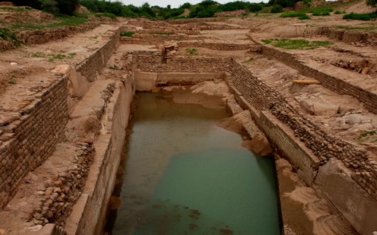
The Genius of Dholavira's Water Management
Water was a precious resource in an environment as arid as Dholavira's. The inhabitants developed an advanced Dholavira water harvesting technique, including reservoirs, dams, and channels, to capture and store rainwater from two seasonal rivers. This system was pivotal for their survival and prosperity.
Components of the Water Management System
The Dholavira water management system consisted of several key components. Large reservoirs were excavated near the city walls, designed to store rainwater. The Dholavira drainage system was equally impressive, with covered drains lining the city streets, ensuring hygiene and preventing waterlogging.
Sustainability and Efficiency
What sets Dholavira apart is not just the scale of its water management endeavours but the sustainability and efficiency of the system. The ancient engineers of Dholavira had a profound understanding of hydrology and civil engineering, allowing them to maximise water retention and usage.
The Role of Water in Dholavira's Urban Planning
Water management in Dholavira was not an afterthought but a cornerstone of its urban planning. The city's layout, including its citadel, middle town, and lower town, was designed with water storage and distribution in mind, showcasing a harmonious blend of functionality and aesthetics.
Technological Advances and Innovations
The Dholavira civilisation employed several technological advances in their water management system. These included stone-cut channels and reservoirs, meticulous town planning to prevent erosion and maximise water collection, and even methods to purify and distribute water.
Conclusion
The water harvesting techniques of Dholavira are a remarkable legacy of the Harappan sites, demonstrating the advanced understanding of engineering and sustainable practices in ancient times. Dholavira's ingenuity in water management is a beacon of innovation, reminding us of the importance of harmonising with our natural environment.
Experience Dholavira
Embark on a luxurious journey back in time to the Harappan city of Dholavira with Evoke Dholavira. Immerse yourself in the ancient city's life, explore its ruins, and marvel at the stunning views surrounding this UNESCO World Heritage site, all while enjoying the unparalleled hospitality and comfort of Evoke Dholavira.
#dholavira water management#dholavira water management system#dholavira water harvesting#dholavira civilization#dholavira drainage system#harrapan sites
0 notes
Text
Mohenjo Daro - UrduMaza
Read More at https://urdumaza.co.uk/mohenjo-daro/
Mohenjo Daro
People living in the contemporary world show great interest in the oldest known civilizations of the world. The civilizations died thousands of years ago but still have their remains which give an idea about their culture and the lifestyle they had. This thing comes naturally to people that they show interest in knowing about history by visiting different museums and other historic sites. The historians are another big source for developing interest in general public with the great true stories that they come up with in different magazines, journals and history books. Mohenjo Daro is one of the oldest known civilizations of the Ancient Indus Valley which was in place around 2600 BC.
Mohenjo-Daro archaeological site is in Sindh, province of Pakistan. It is regarded as the oldest urban settlement of the world which still has it remains in the today’s world. The Mohenjo Daro got abandoned in the 19th century BC era and was rediscovered in 1922. The archeologists from different parts of the world gathered here for the considerable excavation conduction at the site which was later acknowledged by UNESCO in the year 1980 as a World Heritage Site. There are some threats to the site by improper restoration and erosion which needs to be addressed for preserving it for a number of future generations.
Hitler’s Death Squad
Name:
Mohenjo-Daro is actually the contemporary name of the site which is in Sindhi language and it means ‘Mound of Dead’. The original name of the place is still unknown but according to some historians, he possible ancient name was ‘Kukkutarma’ which means’ City of Cockerel’. This name is not authentic and for this reason it never gained any official status. Cock fighting in the Mohenjo Daro used to be a very sacred and religious ritual. The disciplined chickens were bred in the region in the ancient times for very sacred purposes. Mohenjo-Daro is also touted as the main area of diffusion of the domesticated chickens worldwide.
Where Mohenjo Daro is located:
Mohenjo Daro is part of the Larkana District which is on the right side of the River Indus in the province of Sindh, Pakistan. It is about 28 Kilometers away from the town of Larkana. The site of Mohenjo Daro has a unique place between the rivers of Ghaggar-Hakra and the Indus. The Pleistocene ridge of the site is actually in the middle of the floodplain of the River Indus Valley. It was a prominent ridge at the time of Indus Valley Civilization which enabled the place to stand above the surrounding plain. The flooding of the river for quite some time has buried the majority of the ridge in the deposited sludge. The River Indus is still flowing smoothly at the eastern side of Mohenjo-Daro site but the other Ghaggar-Hakra River has dried up for quite some time now.
History:
Mohenjo Daro was built in 26th century BC. It is known as the largest city of the Indus Valley civilization which is also famously known as the Harappa Civilization. The Harappa Civilization was built in 3000 BC having the prehistoric Indus culture. The Indus Valley Civilization of today spans more of what is now Pakistan and the Northern side of India. On the western side, it extends towards the Iranian border and towards the State of Gujarat in India at the southern side. Moreover, on the Northern side, it goes to the area of Bactria.
The major urban centers are at Mohenjo Daro, Harappa, Rakhigarhi, Lothal, Dholavira and Kalibangan. The most notable thing about the ancient city of Mohenjo-Daro is that it was one of the most developed cities of the era. There was some incredible urban planning and outclass civil engineering done by the then people, as reported by the historians. At the time when the Indus Valley Civilization declined in the 19th century BC era, the great Mohenjo Daro was also abandoned. The Mohenjo-Daro Civilization is 4000 years old which is only the second known civilization after the great Chinese Civilization which is 7000 years old.
Rediscovery and the Excavation of Mohenjo Daro:
The remains of the remarkable Mohenjo Daro ancient city were left undocumented for more than 3700 years. It was with the efforts of R.D. Banerjee who took the initiative of rediscovering the site. R.D. Banerjee who was also famously known as Rakhaldas Bandyopadhyay was part of the Archaeological Survey of India as a renowned archaeologist. He actually went to the site for the identification of the stupa of Buddhists from the 150 to 500 CE eras which was supposedly there. He came across a flint scraper which eventually convinced him that it is a very old ancient site. He returned again in the year 1922 for further excavation and this time John Marshall (an archaeologist) was accompanying him as well. It was in 1930 when some serious excavations were performed at the Mohenjo Daro site which was led by John Marshall, Ernest Mackay and D.K. Dikshitar.
Then, things came to a halt until the year 1945 where again the exaction conductions took up in pace. His time, the notable archaeologists were Mortimer Wheeler and Ahmad Hasan Dani. The last most notable excavations at the site were conducted in the year 1964-65 under the leadership of Dr. George F. Dales. It was soon after this time in 1965 when a ban was imposed on further excavations due to the potential threat to the exposed structures through weathering damage. However, there were still some considerable projects carried at the site which includes the surface surveys, conservation projects and the salvage excavations but no hardcore excavations were performed at all. It was then in the year 1980 when Italian and German archaeology survey teams came under the leadership of Dr. Maurizio Tosi and Dr. Michael Jansen. They came with innovative and sophisticated techniques which used very less invasive approaches which includes the likes of localized probing, architectural documentation and the surface surveys. This effort helped the archeologists with lots of information about the Mohenjo Daro civilization which soon became public.
Architecture:
The architecture of the Mohenjo Daro site give glimpses of an urban infrastructure which those people had in their times. It was evident because of their much planned layout which was primarily based on a street grid for giving the then advanced and developed rectilinear buildings. Most of the construction at that time was done using the mortared and the fired bricks. There are some traces found of the wooden structures and also the use of sun-dried mud brick in a variety of construction projects. The covered area of the site is about 300 hectares. The population of Mohenjo Daro with a weak estimation at their peak time was around 40000.
The big geographical area of Mohenjo Daro and the sophisticated facilities and the public buildings of that time give an indication of having a top level social organization of that time. The city of Mohenjo Daro is divided into two major parts which are the Lower city and the Citadel city. The names are fictitious because of lack of evidence. In the Citadel City, there is a mud brick mound that is 12 meter in height. It is also known to have the public washrooms and a vast residential structure which can accommodate 5000 people at a time. Moreover, two spacious assembly halls were also there which were used for varied purposes. The Citadel City also had a common marketplace and a big well. The individuals and also the groups of household used the wells for satisfying their water needs. The waste water was intelligently channeled to cover all the drains going through the major lanes/streets.
Streets of Mohenjo Daro
Some of the residential structures which presumably belonged to the wealthy inhibitors of the time used to have attached bath with their rooms. There were also some traces found of an underground furnace (hypocaust) which most probably was used for heated bathing. Most of the residential buildings at the time had courtyards along with doors which opened towards the side-streets. Moreover, there were several houses which were double-story.
It was during the excavation of 1950, led Sir Mortimer Wheeler who actually identified a vast structure as the ‘Great Granary’. It was a huge wooden structure with wooden wall divisions which served them as a grain storage area. The structures, surprisingly also had the air ducts for the purpose of drying the grain. According to Sir Wheeler, people used carts for bringing grain from remote areas and the offload grain directly in the storage bays. Just next to the Great Granary is a grand public bath which also is known as the Great Bath sometimes.
Great Bath, Mohenjo daro
The Mohenjo Daro site is a great heritage site and it is the responsibility of the lawmakers to take serious steps about its preservation. There were some recent threats to the site due to some cultural programs arranged in the area by the local Sindh government. However, timely intervention by the head of Archaeology Department from Punjab University Pakistan did a great job in its preservation. There is a need of some serious efforts to make sure the preservation of this incredibly unique Mohenjo Daro site.
0 notes
Text
Discovering Dholavira: Unveiling the Secrets of Harappan Civilization
Nestled in the heart of the Kutch district, Dholavira is a testament to the ingenuity and foresight of the Harappan civilization. Known for its historical significance and archaeological marvels, Dholavira offers a unique glimpse into one of the world's oldest urban settlements. This Dholavira tourist guide aims to unveil the secrets of this ancient city, guiding you through its mesmerizing ruins and the remnants of a once-thriving culture.
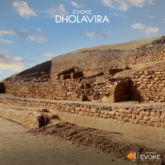
The Journey to Dholavira
Dholavira, located in the arid landscapes of Gujarat, India, is accessible by road from major cities in Gujarat. The journey to this ancient site is as fascinating as the destination itself, with the rugged terrains of the Kutch offering a stark yet beautiful backdrop. Once you arrive, the sense of stepping back in time is palpable, as the ruins whisper tales of a civilization that mastered the art of living in harmony with nature.
Exploring the Marvels of Dholavira
Dholavira tourism is not just about exploring the ruins; it's about connecting with a civilization that was advanced beyond its years. The city is divided into multiple zones, including the citadel, the middle town, and the lower town, each showcasing the Harappan way of life. Notable places to see in Dholavira include the water reservoirs, which highlight the Harappans' expertise in water conservation, and the signboard, which bears one of the earliest examples of written language.
The archaeological site also offers insight into the town planning, architecture, and social hierarchy of the Harappan people. As you wander through the ruins, the strategic planning of the city, with its well-laid streets and expertly constructed drainage systems, becomes evident, showcasing the advanced urban planning skills of its inhabitants.
Embracing Dholavira's Tranquility
Beyond its historical and archaeological significance, Dholavira exudes a serene ambiance that captivates every visitor. The vast expanses of the surrounding desert, the stunning sunsets, and the clear night skies make Dholavira not just a place for historical exploration but also a retreat for those seeking tranquility amidst nature.
Accommodation in Dholavira
For those wondering about places to stay in Dholavira, Evoke Dholavira offers a comfortable and immersive experience. Nestled close to the archaeological site, the resort provides a perfect base for exploring the ancient ruins and soaking in the timeless beauty of the surrounding landscape. With well-appointed rooms and top-notch facilities, it ensures that your stay is both memorable and comfortable.
The best time to visit Dholavira is from October to March when the weather is cooler and more conducive to exploration. Ensure to carry water, sun hats, and sunscreen, as the area can get quite hot during the day. Hiring a local guide can greatly enhance your understanding of the site and its historical context.
Conclusion
Dholavira is not just a tourist destination; it's a journey back in time to one of humanity's earliest urban centers. Through its impressive ruins and museums, it tells the story of a civilization that, though ancient, was incredibly advanced. The tranquility of its desert surroundings, coupled with the rich historical tapestry, makes Dholavira a must-visit for anyone fascinated by history, archaeology, or simply the beauty of ancient cultures. And with accommodations like Evoke Dholavira, your trip to this timeless city will be as comfortable as it is enlightening.
#dholavira tourist guide#dholavira tourism#dholavira tourism places#places to see in dholavira#places to stay in dholavira#dholavira located
0 notes
Text
NCERT Class 12 History Chapter 1 Bricks, Beads and Bones The Harappan Civilisation
NCERT Class 12 History Solutions
Chapter 1 Bricks, Beads and Bones The Harappan Civilisation
NCERT TEXTBOOK QUESTIONS :
Q 1. List the items of food available to people in Harappan cities. Identify the groups who would have provided these.
Ans.
Q 2. How do archaeologists trace socio-economic differences in Harappan society? What are the differences that they notice? [Delhi, All India 2009, 2011]
Ans. Following examples can be cited to show the existence of social and economic variations : in the Harappan society:
(i) Study of burials is one example. In the Harappan sites, the deads were usually laid in pits. There were differences in the Way burial pits were made. At some instances, the hollowed-out spaces were lined with bricks. But these may not be taken as an indication of social differences.
(ii) In some graves pottery and ornaments have been found. Jewellery has been found from the graves of men and women as well. These findings can point out social and economic differences. ‘
(iii) The artefacts have been classified into two categories, Utilitarian and Luxurious. Objects of daily uses and objects made of ordinary materials made of clay or stone come under utilitarian category. Ordinary articles consisted of querns, pottery, flesh-rubbers and needles. These have been found distributed throughout settlements.
(iv) Objects of luxuries were rare and made from precious, non-local materials. The technology used was advanced and complicated. Little pots of faience were considered precious. They were also not easy to make. These show the existence of social and economic variations in the Harappan society.
Q 3. Would you agree that the drainage system in Harappan cities indicates town planning? Give reasons for your answer.
Ans. Yes, I agree with that the drainage system in Harappan cities which indicates the town planning. I can cite the following reasons in support of my answer.
The drainage system needed a planning for its execution. It seems that first drainages were laid out and then houses were built along with the drains. Every house was supposed to have at least one wall along a street to allow the domestic waste water to flow out in the street drains. The plans of the lower town show that roads and streets were laid out along an approximate grid pattern, intersecting at right angles.
It appears that human settlement was made by planning from the beginning. The city was restricted to a fixed area on the platforms.
Bricks, sundried or baked, were of standard ratio. The length and breadth of bricks were of four times and twice the height respectively These bricks were used at all the settlements of the Harappan Civilisation.
Q 4. List the materials used to make beads in the Harappan Civilisation. Describe the process by which any one kind of bead was made.
Ans. Making beads was an important craft of the Harappan people. It was mainly prevalent in Chanhudaro.
Materials for making beads included beautiful red coloured stone-like camelian, jasper, crystal, quartz and steatite. Besides these, use of copper, bronze, gold, shell, faience, terracotta or burnt clay was also used.Process of making beads Making of beads differed as per the materials used. Beads had variety*of shapes. They did not make geometrical shapes like one made of harder stones.
Nodules were to be chipped for making rough shapes. They were finally flaked into the final form.
By firing the yellowish raw material, the red colour of camelian was obtained. Grinding, polishing and drilling constituted the last phase. Chanhudaro, Lothal and Dholavira were famous for specialized drilling.
Q 5. Look at figure 1.30 (See NCERT page-26) and describe what you see. How is the body placed? What are the objects placed near it? Are there any artefacts on the body? Do these indicate the sex of the skeleton ?
Ans. Following observations can be obtained after looking at the figure:
Body has been kept in North-south direction in a pit,
Many graves contain pottery and ornaments which include jar.
Yes, jewellery like bangles are there on the body.
Yes, this indicates towards the sex of the skeleton, Le. it is the body of a woman.
It is concluded that there were great social or economic differences among the people living within the area of the Harappan Civilisation. But as a whole it appears that the Harappan did not believe in burying precious things with the dead.
Q 6. Describe some ofthe distinctive features of Mohenjodaro. [Delhi 2013]
Ans. Planned City: Harappa as a planned urban centre. It had two parts. One part of the city was small. It was built on a higher place.
The second part was comparatively large. It was built on a lower place. The first part was designed as citadel and the second part was as lower town. The citadel owed its height to the fact that it was built on mud brick platforms.It had walls on all sides and these walls were separated from the lower town.The Lower Town: It was also a walled town.Most of the buildings were built on platforms.
In fact, these platforms were considered as foundation stones. It required huge quantity of labour force to build these platforms. It is obvious that settlement was first planned and then implemented as per the building plan.Quality of sun-dried bricks or baked bricks also prove the concept of planning.
All the bricks were of standard ratio. The length and width was four times and twice the height of the bricks respectively. These bricks were used in the settlements of the Harappan Civilisation.
Drainage System: The drainage system was well planned. All the roads and streets were laid out on a grid pattern. They intersected one another at the right angles. It seems that streets featuring drains were laid out first and houses were built thereafter along with them. To make the flow of domestic water, every house had at least one wall along the street.
The Citadel: There were many buildings in the citadel. These buildings were used for many special public purposes. The Warehouse and the Great Bath were the two most important constructions.
Q 7. List the raw materials required for craft production in the Harappan Civilisation and discuss how these might have been obtained.
Ans. Following is the list of materials required for craft production in the Harappan Civilisation:
Stone, clay, copper, tin, bronze, gold, faience, shell, camelian, jasper, crystal, steatite, quartz, timber.
Some of the raw materials were locally available whereas some were purchased from the distant places. Soil and wood were locally available raw materials. Stones, fine quality wood, metals were procured from distant places.
Settlements of the Harappans were situated at such places where raw materials were easily available. Nageshwar and Balacot were famous for shell. Some places were famous for Lapis Lazuli like Shortughai in Afghanistan. Rajasthan and Gujarat were famous for copper. Lothal was famous for camelian.
Another way of obtaining raw material was sending expeditions to different places.
Evidences show that expedition was sent to Khetri region of Rajasthan for copper and to South India for Gold. Through these expeditions local communities were contacted. Harappan evidences found at these places indicate contacts between each other. Evidences found at Khetri region were given the name of Ganeshwar Jodhpura Culture by archaeologists. Huge reserves of copper products were found here. It is assumed that inhabitants of these area sent copper to Harappan people.
Q 8. Discuss, how archaeologists reconstruct the past.
Ans. Archaeologists excavate the sites of the ancient past related to culture or civilization. They find out the art and craft such as seal, material, remains of houses, buildings, pots, ornaments, tools, coins, weights, measurements and toys, etc.
Skulls, bones, jaws, teeth of the dead bodies and materials kept with these dead bodies are also helpful for archaeologists. With the help of the botanists, and zoologists, archaeologists study the plants and animal bones found at different places.
Archaeologists try to find out the tools used in the process of cultivation and harvesting. They also try to find out traces of wells, canals, tanks, etc. as they served means of irrigation.
Different layers of sites are observed to find out different things. These things give the picture of socio-economic condition such as religious life and the cultural life of the people.
Tools, unfinished products, waste materials, help in identifying the centres of craft production. Indirect evidences also help the archaeologists in reconstructing the past.
Archaeologists develop frames of references, It can be better understood by this fact that the first Harappan seal that was found could not be understood till archaeologists had a context in which to place it-both in terms of cultural sequence in which it was found and in terms of a comparison with finds in Mesopotamia.
Examination of seals help in constructing the concept of religious belief of the period. Seals depict religious scenes. Some animals such as the one-homed animal, often called the unicorn depicted on the seals appear mythical, composite creatures. In some seals, a figure has been shown sitting crossed legs in a yogic posture. All these represent the religious concept of the period.
Q 9. Discuss the functions that may have been performed by rulers in Harappan society.
Ans. There are different views on the Harappan society. One group of archaeologists suggest that the Harappan society had no rulers and so everybody enjoyed equal status. The other group of archaeologists are of the opinion that there was no single ruler but several ones. The third theory seems the most suitable. It suggests that it is unlikely that entire communities could have collectively made and implemented such complex decisions.
Evidences show that complex decisions were taken and implemented in the Harappan society. Extra ordinary uniformity of Harappan artefacts as evident in pottery, seals, weights and bricks show the complex decisions.
Plans and layouts of the city were prepared under the guidance and supervisions of the rulers. Big buildings, palaces, forts, tanks, wells, canals and granaries were constructed.
Cleanliness was the responsibility of the ruler. Roads, lanes and drains were also constructed.
The rulers also looked after the welfare of the economy. They hsed to inspire the farmers to increase agricultural production. They also motivated the craftsmen to promote different handicrafts. External and internal trade were both promoted by the ruler. The ruler used to issue common acceptable coins or seals, weights and measurements.
Rulers were expected to provide relief during natural calamity. During flood, earthquake, epidemics, the ruler provided grains and other eatables to the affected people. During foreign aggression, the rulers defended the city.
Q 10.On the given map, use a pencil to circle the sites where evidence of agriculture has been recovered. Mark an X against sites where there is evidence of craft production and R against sites where raw materials were found.
Ans.
(i) Sites of agriculture: Harappa, Banawali, Kalibangan, Mohenjodaro, Dholavira (Gujarat).
(ii) Sites of craft production: Chanhudaro, Nageshwar, Balakot.
(iii) Sites of raw material: Nageshwar, Balakot, Khetri.
via Blogger https://ift.tt/2PSwT1X
0 notes
Last Seen Blogs

munster0us
Horrors Beyond Your Imagination….and Fanart

superstarhempadidasbg-blog
superstar hemp adidas - jesus christ superstar full album

animaasolitaria
πάθει μάθος

zeventkat
Zevent Kat

how-about-i-just
Who needs physics when you can just blow it up?