
Last Seen Blogs

cattybat
DAFU

tuestanio
TuestanioShinigami


willogenic
The Starless Satellite

inloveforevr
Living my best life!
Text
Blog #9
Adaptive Reuse -
There are many areas throughout Cincinnati that could use and benefit from adaptive reuse. Adaptive reuse refers to the process of reusing an existing building for a purpose other than what it was originally designed for. Adaptive reuse can be seen in buildings such as single family houses all the way to multi level commercial buildings. Some areas around Cincinnati that we think could benefit the most from this process is areas where there are a mass amount of buildings in an area that do not provide what is needed for the community around it. For example, if a neighborhood is struggling from a lack of a central business district but all of the buildings are residential, you can start by transforming an area with a higher concentration of vacant residential buildings and flip from providing housing to providing retail space for different businesses to move in and start to create that identity of a business district. This also goes for areas that may have too much commercial and too little housing. They can start to turn some of these non-thriving businesses into single, double, or even triple family residences.
Modular Design -
Pre-fabrication -
Pre-fabrication in the construction of any building is the use of pre-manufactured parts such as wall panels and supports, up to entire rooms and units. Pre-fabrication can either be a small part of the construction process or a key aspect, with fully pre-fab houses becoming more and more popular.
Pre-fabricated houses could be a good choice for Cincinnati as they are both cheaper and quicker to produce, being proposed as a solution in places such as Vancouver who are struggling to keep up with rising housing demand. Building both houses and apartments using pre-fab methods can save up to 30% and take up to 50% less time. However, It would likely be up to the City of Cincinnati to incentivize developers to employ pre-fabrication for it to catch on.
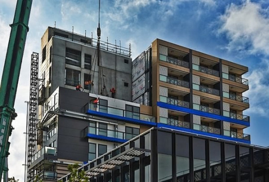
Example of a fully modular, pre-fab apartment complex being constructed.
Green Technology -
0 notes
Text
Blog #8
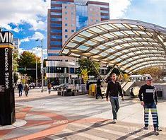
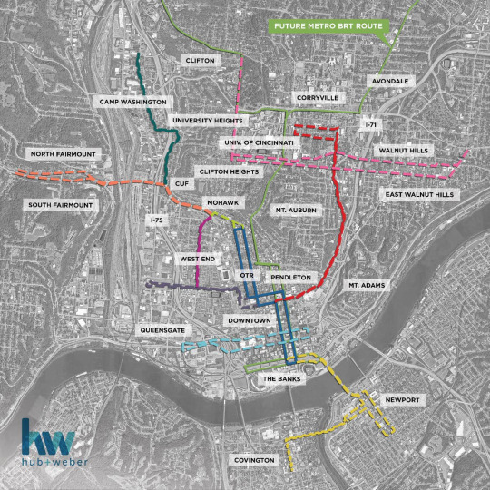
Historical Background of BRT stop neighborhood - Corryville
The neighborhood of Corryville was founded in 1843. Corryville lies on land that was originally owned by two men, Jacob Burnet and William McMillan. Both names now found on a nearby road and park. In 1870, Corryville was officially annexed by the city of Cincinnati. A considerable influx of Germans settled in the neighborhood as they left Over the Rhine. In the 1960s, development in and around the nearby University of Cincinnati resulted in the construction of University Plaza shopping center and the rerouting of Vine Street to Jefferson Avenue. Jefferson Avenue is now the main passageway on the boarder of Corryville, where the West University Avenue Metro stop lies, which is planned to be a future BRT stop.
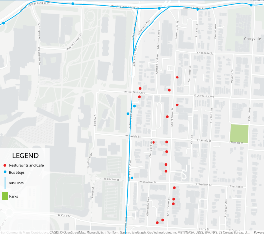


The 86 is a nearby coffee shop directly across the street from the bus stop. It's a great place for people to meet and a good attraction.

0 notes
Text
Blog #7
What is TOD?
Transit-Oriented Development (TOD) is an urban planning and design approach that focuses on creating sustainable, walkable communities centered around well-connected public transportation systems. The primary goal of TOD is to maximize the convenience and accessibility of public transit, encouraging people to use buses, trains, and other forms of public transportation instead of relying on personal vehicles.
A Negative of TOD:
Lack of public transportation options can contribute to social isolation, particularly among those who cannot drive or afford private transportation. This isolation can affect mental well-being and community solidarity. Individuals who are unable to drive, such as the elderly, disabled, or economically disadvantaged, may face challenges in accessing essential services and participating in community activities. This limited mobility can result in feelings of isolation and exclusion.
Insufficient public transportation options compel individuals to heavily depend on private vehicles, consequently exacerbating traffic congestion within urban areas. The reliance on personal cars not only leads to wasted time due to prolonged commutes but also significantly contributes to environmental issues. The increased volume of vehicles on the roads intensifies traffic congestion, leading to gridlocks and inefficiencies in the transportation system. Moreover, the high concentration of cars emits pollutants into the air, contributing to elevated levels of air pollution. This pollution poses serious health risks, as it includes harmful substances such as particulate matter and nitrogen oxides.
Positives of well planned TOD:
Well planned transportation development promotes efficient and accessible public transportation systems, reducing dependence on private vehicles and alleviating traffic congestion. This not only enhances the overall mobility of residents but also mitigates environmental issues by curbing air pollution and lowering carbon emissions. TOD fosters compact, mixed-use developments, creating pedestrian-friendly neighborhoods where residents can easily access amenities, educational institutions, and job opportunities. The concentration of services around transit hubs encourages walking and cycling, promoting a healthier lifestyle.
TOD often leads to increased property values, attracting private investments and spurring economic development. By fostering a sense of community, encouraging social interactions, and supporting local businesses, transit-oriented development contributes to the creation of vibrant, resilient, and sustainable urban spaces. Ultimately, these positive aspects enhance the overall quality of life for residents while promoting environmentally responsible and economically viable urban planning.
An example of TOD is:
One example of Transit-Oriented Development (TOD) in the United States is the Clarendon-Courthouse area in Arlington, Virginia, part of the Washington, D.C. metropolitan region. Arlington has been recognized for its commitment to sustainable urban planning and transit-oriented development.
Clarendon-Courthouse is served by the Washington Metro's Orange and Silver lines, providing direct access to the D.C. metropolitan area. The metro stations, Clarendon and Courthouse, are centrally located within the development, facilitating convenient transit options. The area features a mix of residential, commercial, and retail spaces within close proximity to transit. High-density, mixed-use developments encourage residents to live, work, and shop in the same neighborhood, reducing the need for extensive commuting.
The streets in Clarendon-Courthouse are designed to be pedestrian-friendly with wide sidewalks, street-level retail, and outdoor seating. This promotes walkability and creates a vibrant urban environment. Arlington has invested in bicycle infrastructure, including bike lanes and bike-sharing programs. This supports alternative modes of transportation and contributes to the overall sustainability of the development.
Arlington County has implemented policies to encourage the inclusion of affordable housing units in new developments. This commitment to housing affordability helps maintain socio-economic diversity within the community. Clarendon-Courthouse features public spaces such as Clarendon Central Park, providing areas for community gatherings and events. The presence of public spaces enhances the social fabric of the neighborhood.
The success of Clarendon-Courthouse TOD lies in Arlington County's commitment to sustainable urban development, transit accessibility, and community engagement.
0 notes
Text
Blog #6
What are possible ways of alleviating food insecurity in Cincinnati (including UC campus)?
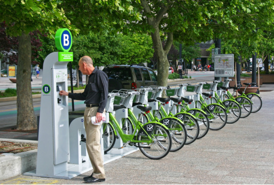
Bike Share
There are many areas in Cincinnati that most people in that area don’t have easy access to grocery stores. This could be because of multiple things. It could be because the person doesn’t own a car, bike, or other modes of transport. By adding a bike share in these areas, it allows people who can’t easily get to the grocery to have a cheap and quick mode of transportation.
Food Bank
most of the food insecurity related with low income, A research by Community Health Status Survey indicated that 31% of food insecurity in Ohio are caused by low income. food bank can significantly help decrease the problems brings by that if it possible for low income groups to get lower price or even free good supply periodically. the subsidy and donation can help to support and keep food bank maintain, by the result the allative of food insecurity also help increase the sense of safety in community.
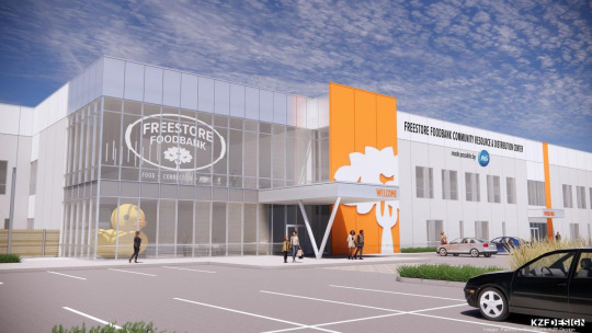
image by By Tom Demeropolis
Urban Garden
One way to keep UC students and Cincinnati residents happy, healthy, and fed is by the use of urban gardens. They are easy to use, cheap, and don't take up a lot of space. They require very little maintenance so anyone could start one if they have the resources to do so. This would provide fresh, cheap, and healthy food to those in need.
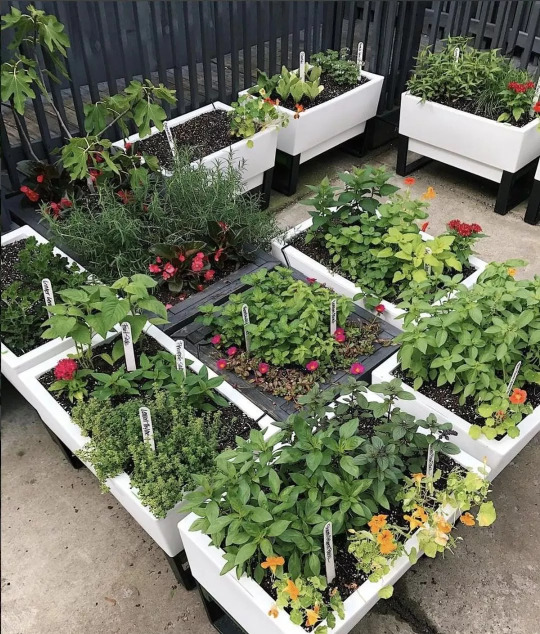
via Extra Storage Space
Extending Store / Cafe Hours
Many stores and cafes around Cincinnati used to remain open either 24hrs or much later into the night, usually midnight. After Covid ravaged the U.S. in 2020, many stores and cafes began closing up earlier in the day. This places people who go to work early / get off late at a disadvantage as most food options open late and close much earlier than they did pre-2020. Extending the hours earlier in the morning / later into the night of food sources would benefit such people.
At U.C., all but one dining hall is closed after 8pm, and the final one closes at 10pm. Dining halls don't begin operations until 7/8am the next morning. The dining halls closing so early creates a food desert on campus at peak dinner times for college students. Most students are working late into the night and have late dinners. Unfortunately, many go home hungry late at night because the food halls close so early. Extending the hours would eliminate this issue and students would take further advantage of their meal plans.
0 notes
Text
Blog #5
What types of regional and local transport does Cincinnati need more in the future?
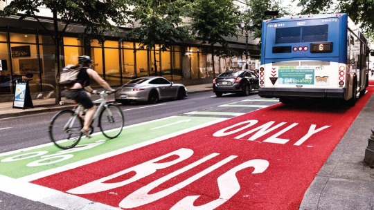
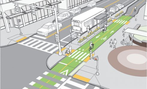
BRT (Bus Rapid Transit)
While Metro Buses are a somewhat acceptable form of transportation for Cincinnati's citizens, BRT would transform the way people commute and travel throughout the city. Bus Rapid Transit would result in cheap, fast, and efficient transportation. This is due to multiple factors, including designated lanes for the buses, so they would never get stuck in traffic or behind other cars. In addition, BRT will have a unique relationship with traffic lights to ensure the passengers get to their destination as quickly as possible, which will be discussed in this post later. These buses will have routes specifically designed to stop where there is the most dense population. This will not only help all the people living there, but also help sustain the costs of running a system such as this.
By Implementing Bus Only lanes the BRT will have the right of way on the road and not get stuck in large swaths of automobile traffic. The existence of bus only lanes also legitimize the efficacy of bus transport and spread awareness of its existence for potential riders. It helps strip away the taboo that riding the bus has picked up over the years as it is seen as part of the infrastructure, like a subway. While there are a few downsides they all have their own solutions such as drivers simply adapting to the changes and combing bus lanes and right turn lanes when needed.
With the addition of the BRT, there will have to be new stations added at all the new stops along the corridors. These stops should include a covered platform with access to the platform for wheelchairs and bikes. The platform should be raised to match the bus height to have a smooth boarding process. It is important to have nice quality stations to draw people to use the bus system.
The characteristic of signal lights in the context of Bus Rapid Transit (BRT) systems typically involves priority treatment at intersections. This means BRT buses are often given precedence through traffic signals, either by extending green lights or reducing red light durations, to ensure quicker and more reliable bus transit times. Once bus reach signal light it will automatically send signal to signal light, it will turn green not longer than 15 seconds and left enough time for pedestrian to pass. This feature is part of a suite of strategies aimed at improving the efficiency and attractiveness of BRT systems, by minimizing delays commonly experienced at intersections.
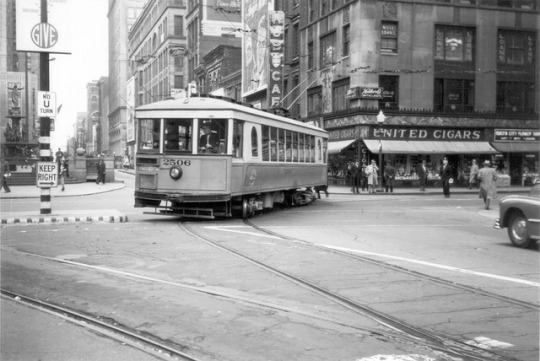
Streetcar
Cincinnati formerly had an extensive streetcar system that proved to be quite important by means of transporting people around Cincinnati and its surrounding neighborhoods. This existed from the late 1800's to the mid 1900's and was a cheap, accessible, and fast way of transportation. This was what many people considered the Segway between horse and carriage and personal cars. They had their own designated lanes to ensure faster speed and cost very little to ride, so all classes alike could share transportation.
Via Wikipedia
However, since the takeover of the automobile, the streetcar system has since been removed. In the recent decade, however, a new system was added connecting OTR, downtown, and the banks in Cincinnati. The new streetcar, called the Cincinnati Bell Connector, has only seen increased ridership since it first began operating in 2016. However, its current route is extremely limited, and the streetcar is mainly utilized recreationally.
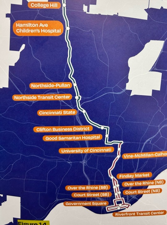
There has been a noticeable push from both city officials and residents of Cincinnati to expand the streetcar. Streetcar expansion would see an absolute increase in ridership as communities farther away from downtown and OTR are now connected to the line, and people will be able to commute via the streetcar to work.
Several lines have been proposed, with two being selected with the most consideration. The most notable being an extension up Reading Road that loops around in Corryville, thus transforming Corryville into a more connected community, and connecting Corryville to downtown Cincinnati. The second proposition would be a separate line riding along the southern portion of UC and extending into Walnut Hills. This loop would connect the University and all the business around it to the neighborhoods in and around Walnut hills and northern Mt. Auburn / southern Corryville, which would serve incredibly beneficial for those who commute to the UC area for work or school from Walnut hills.
Cincy Streetcar from X.com
0 notes
Text
Blog #4
What’s the “best” density for the design of cities today? Find an example of the city block in Cincinnati. Measure its housing density (units per acre) and explain how its elements make the best quality of urban environment.

Two blocks between Marian Spencer and Joe Nuxhall Way - Google Maps
Between Marian Spencer Way and Joe Nuxhall Way lies two blocks with a F.A.R. of 3.4. Beneath there are several restaurants providing different style cuisine. all restaurants are located in first floor of a mixed use building, and above level are all resident houses. there are also several other functional or commercial space like fitness rooms and banks. some much expensive gourmet service for example, Yard house and Moerlein Larger House own batter river and park view. Each apartment design as a small blocks with varies inner public parks or swimming pool. As National Underground Railroad Freedom Center as axle wire, the whole community is highly symmetric, all residents will have their needs met daily.
WALKABILITY
E Freedom Way gets shut down for certain events like sports games, festivals, and other celebrations. The street becomes pedestrian only, with people having access to all the local restaurants and shops. This creates a fun, exciting environment for people to enjoy, with twinkling lights, picnic tables, and turf grass areas. But, even when this is a functioning street for cars, it is still extremely walkable, with wide sidewalks and plenty of crosswalks. This is convenient not only for tourists visiting, but also for the people who live in the apartments.
Via Lewis and Clark Travel
TRANSIT
On top of that, there is also easily accessible public transit situated nearby. Just north of the two blocks lies a tram stop for the Cincinnati Bell Connecter. This tram stop lies right atop of the northern of the two blocks, and the tram services the station every fifteen minutes roughly. The tram may take residents of these blocks up north into Cincinnati's business district, then into OTR, where it makes several stops around markets, stores, restaurants, parks, and other important places such as Music Hall. The tram also returns to the stop. A metro bus stop lies just a block west of the two blocks, where the metro bus frequents and may also take residents throughout the city and in surrounding neighborhoods. These two transportation stops keeps the two blocks well connected to Cincinnati.
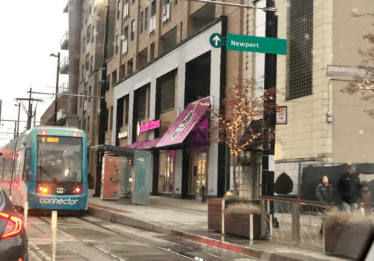
Cincinnati Bell Connector at The Banks stop on E. Second St. - https://adventuremomblog.com/what-you-need-to-know-about-snow-banks-at-the-banks/
PARKS
South of the two blocks lies the Smale Riverfront Park and other adjoining walkways and parks. These parks have a marvelous view of the Ohio River and the Roebling Bridge. On the riverfront park there are several playground structures for children to enjoy underneath the forgiving shade of various trees. Around the park there are also grass fields for events to take place or for people to enjoy playing sports like frisbee, football, catch, etc. On hotter days in the summer, park goers may find relief under the shade of dozens of trees planted throughout the park. Summertime also sees more vendors at the park, so park goers may also purchase local goods or get a quick bite to eat and a refreshment. This park is situated right next to the two blocks we are discussing, so residents have quick and easy access to such a great space.

Smale Riverfront Park - https://www.sasaki.com/projects/cincinnati-john-g-and-phyllis-w-smale-riverfront-park/
Convienence:
The density of this block allows it to sit in one of the most desirable spots of the city. Residents within this block have near immediate access to the sporting venues downtown allowing them to walk to Reds, Cyclones, and Bengals games. They can also walk to all the downtowns restaurants and walk to work if they happen to work in one of the many office buildings downtown.
DISCUSSION QUESTION
Should Cincinnati crack down on the construction of studio / 1 bedroom apartments such as these?
0 notes
Text
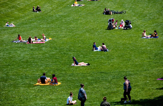
Washington Park
Whyte describes an ideal plaza/public space using 7 main criteria. Washington Park in OTR, Cincinnati perfectly encapsulates what Whyte described and wrote about. We directed each principle of Whyte's and how Washington Park fits the description.
Principle 1
Sitting Spaces
From benches to moveable seats and tables, Washington Park has a plethora of seating available.
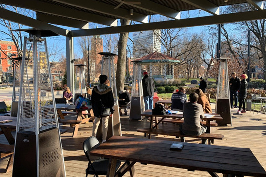
(Cincinnati CityBeat)
As seen here, there is a large gazebo structure in the center of the park with picnic tables and moveable seating. There are heaters there during the winter season so people can still enjoy the park in the cold, as well as a cover incase it rains. The tables create a shared public experience that strangers can come and share together.
This image shows both the benches that line the entire park and the moveable chairs and tables that are both perfect seating areas. This provides an enjoyable seating experience for park guests so they can have conversations and relax.
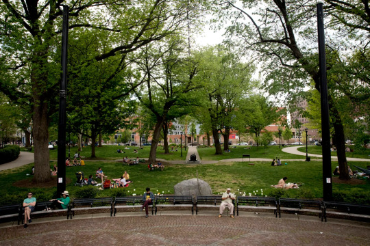
Principle 2
Most important thing about a space is its physical and visual relationship to the street
Whytes second principle is that it is most important for the space to have a strong physical and visual connection to the streets around it. Washington park does an exceptional job at connecting the park to the street. Since Washington park does such a good job of connecting itself to the streets around it, it promotes pedestrians to enter the park since it feels just like the streets they were walking on before. For example, before every FC Cincinnati game, there is a fan supporter parade that goes through Washington park. They can do this because there are no obstructions from the street that wouldn’t allow them to easily enter the park.
Principle 3
Light is vital, even if bounced/reflected from other
buildings; the sun is only importanton cold days
In Whyte’s book “The Social Life of Small Urban Spaces,” he wrote about the importance of lighting in plazas. Washington Park offers multiple diverse sources of light, each attributed to the comfortable environment of the plaza. Within the water features there are lights included under the water fountain. As shown in the image given. This creates a playful and visually attractive feeling for the plaza. These lights do not create glares or harsh shadows confiding to Whyte's principles. The open space of the plaza allows for plenty of sunlight to reach the area. As for nighttime ambiances, many lighting fixtures and lamp posts are provided to light up pathways and popular areas.
Principle 4
Water: fountains, rain garden, pond, water sounds are vital
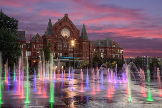
fountains and water element could be most critical and attractive parts of Washington Square Park for tourist, It has a multi-function water recycle system. the spar ground in the surface level is the most tourist friendly part of whole system. it a good place for all age tourist surrounded by bower and chair, it actively interactive with tourist, and the water are all natural collective by collect system and purified by underground purify system. most of water use in green space and rain garden of Washington Square Park are all from this system, even the toilets water use are supported by this system. Father more, they hold a lot vocation events in spar ground during summer, festival and any other necessary times.
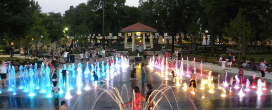
image by 3CDC
Principle 5
Trees create semi-enclosed spaces and help shade and reduce glare
In Washington Square Park, trees are strategically used in certain parts of the park. On one end there is a large clearing which allows more open movement and a place for those to lay out and enjoy the sun.
On the other end there is plenty of seating and an abundance of trees. This provides respite from harsh summer days and rest for those who may have been playing in the sun.
By striking a balance between open and shaded areas Washington Square Park allows for visitors to enjoy themselves more and stay for an extended amount of time.
Principle 6 - Access to Food / Water
Located in the heart of Washington Park is a concession stand called The Porch. This kiosk serves cold and warm beverages along with snacks. The Porch acts as both a shelter away from the elements and a place for parkgoers to refuel without having to vacate the park. During special fairs and events, additional food may be around at pop-up concession stands or small businesses in booths. Not only does this keep people in the park, but it also benefits small businesses.
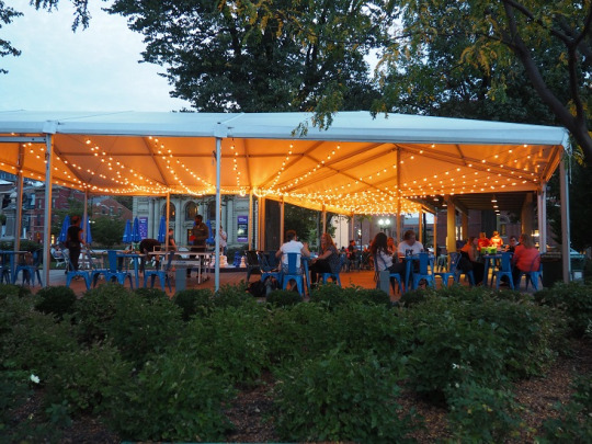
The Porch @ Washington Park - washingtonpark.org
Principle 7 - Triangulation
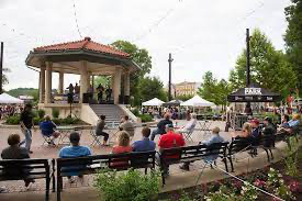
Washington Park has an iconic gazebo in the middle of the park. This gazebo hosts many events, for instance when bands come in or when couples get married. When the park hosts vending fairs, for instance, the vendors are all stationed around the gazebo, and it remains a centerpiece of the event and the icon of many photographs. The gazebo serves as the heart of the park, with arteries of pathways from all over the park leading to a single meeting point at this iconic landmark. As people enter the park, they are directed towards the gazebo, and it remains the center of attention and one of the first noticeable things that catches one's eye as they near closer.
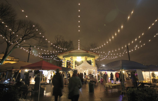
Vendors around the gazebo during the Holiday Market - cincinnatirefined.com
Discussion Question:
Do you agree with us that Washington Park fulfills the 7 criteria from Whyte? Why or why not?
0 notes
Text
Blog #2
Cincinnati is a city full of potential. It is up and coming and slowly becoming a hot spot for many jobs and architecture. However there are many ways Cincinnati can improve its ways and create a city alike Chicago Illinois and Paris France. These cities provide tourism, excellent transit, and walkability.
Cincinnati can definitely take notes.
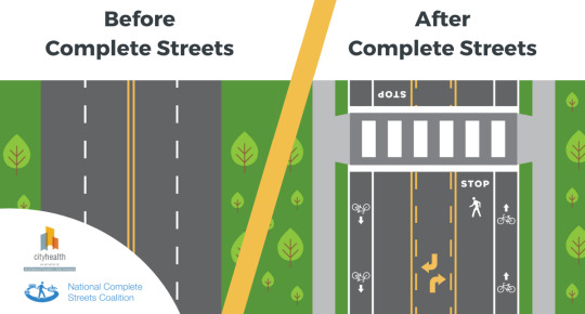
Chicago and Paris are great tourist hubs due to the architecture, parks, and iconic places included within. Chicago contains many tall skyscrapers that give the pedestrians in the streets below a sense that they are in a narrow or enclosed environment. Cincinnati also gives the same feel. By using Haussmann's ideas in his plan of Paris, Cincinnati could possibly try to widen a select few of their streets to replicate what Haussmann did to Chicago. This would not be for every street, and the widening wouldn't just be for cars. Selecting a street to widen such as Liberty Street may include adding dedicated bus lanes so busses do not get stuck in car traffic or adding dedicated bike lanes to improve biker safety. This would help remediate congestion and help to create a more open feel to the city streets.
A pretty critical idea from Chicago redevelopment and rebuild is the walkability of sidewalks. for the city of Cincinnati, some sidewalks obviously lack of sense of that. One reason could be an imperfection of geographic condition. However, some other streets could still make change by better design. a good example would be Clifton Ave. A few years ago, it participated a rebuild with idea of complete street. It now contained both sidewalks, driveway, park place and green space.
Regarding tourism and architecture, a driving force that calls people towards Cincinnati is the rich German heritage in Over-The-Rhine. The history and architecture of the neighborhood is incredibly stunning, and something to be preserved. Along with preserving the rich architectural beauty within Cincinnati, ensuring that new developments are also as charming is critical. Building large tasteless structures captures nobodies attention and gives Cincinnati no unique charm that people flock to witness.
Burnham's vision for Chicago also involved dedicated considerable portions of land for public parks and green space. Cincinnati may not be as large as Chicago, but there are areas that are defiantly lacking in public green space, especially in Cincinnati neighborhoods further north like Bond Hill. Public green space gives people a break from the monotony of being in a city / town and being constantly surrounded by structures and roads. Green spaces may also have tremendous environmental advantages as well, such as cleaning polluted air and filtering contaminated groundwater.
Debate Questions:
Is street widening for busses / bikes beneficial enough to justify widening a street?
Is preserving land for public green space an important characteristic for a city to have or is it a waste of land that could be used for development?
IMG 1 - https://montgomeryplanning.org/planning/transportation/complete-streets/
IMG 2 - https://smartgrowthamerica.org/what-are-complete-streets/
0 notes
Text
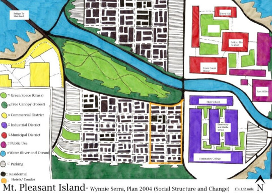
Blog Question 1 - Ideal City
Ebenezer Howard's idea of the garden city most closely emulates our vision of the ideal city. In the garden city concept, there is an emphasis placed on green space such as parks, gardens, and boulevards / parkways with plenty of vegetation cover such as trees present.
Three reasons justifying this ideal city concept:
An abundance of green space
Green space is crucial, especially in an urban environment where green space may be hard to come by. Green space may be grass fields, gardens, parks with trees, playgrounds, sports fields, etc. Such spaces are important to ensure citizens are able to enjoy a space for fresh air, exercise, and a peace of mind out of the busy city. Of course, not too much land will be utilized for green space due to land being such a hot commodity in a city. Such land could also be used to build structures for business and human dwellings, so finding a good balance between the built city and green space is quite important.
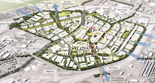
Quick access to resources (15min city)
A garden city places emphasis on resources being readily available to its citizens within a timely manner (15 minute walk). Unfortunately, most cities in the United States struggle with resources such as groceries, parks, and employment being so far away a car must be used. Such sprawled cities also lack public transport, so citizens are forced to rely on the automobile for transportation. When everything one needs is within walking distance, there is no need for dependency on transportation.
Public Transportation
Public transport will aid in efficient movement of people around the city. Instead of thousands of people each using a car if they need to move around, these people can be divided amongst several buses or trains. An addition of bike lanes may also aid in not being car dependent if individuals need to get around, but the distance is too short for public transport and too long to simply walk.
IMG 1 - Bloomburg.com - https://www.bloomberg.com/news/articles/2022-03-21/utah-dreams-up-a-different-kind-of-15-minute-city
IMG 2 - Wynnie Serra (UC DAAP Student)
1 note
·
View note